Report on Pacaya (Guatemala) — May 2017

Bulletin of the Global Volcanism Network, vol. 42, no. 5 (May 2017)
Managing Editor: Edward Venzke.
Edited by A. Elizabeth Crafford.
Pacaya (Guatemala) Steady growth of intra-crater cone during 2016 fills MacKenney Crater
Please cite this report as:
Global Volcanism Program, 2017. Report on Pacaya (Guatemala) (Crafford, A.E., and Venzke, E., eds.). Bulletin of the Global Volcanism Network, 42:5. Smithsonian Institution. https://doi.org/10.5479/si.GVP.BGVN201705-342110
Pacaya
Guatemala
14.382°N, 90.601°W; summit elev. 2569 m
All times are local (unless otherwise noted)
Guatemala's Pacaya volcano has a 450-year record of frequent historical observations of activity, in addition to confirmed radiocarbon dating of eruptions over 1,500 years. Its location approximately 30 km S of the capital of Guatemala City makes it both a popular tourist attraction as a National Park, and a hazard to the several million people that live within 50 km. Activity during the last 50 years has been characterized by extensive lava flows, bomb-laden Strombolian explosions, and ash plumes that have dispersed ash to cities and towns across the region.
Major lava flows and Strombolian activity in January and early March 2014 were previously reported (BGVN 42:04). This report describes activity for the remainder of 2014 through 2016. Information was provided by the Instituto Nacional de Sismologia, Vulcanologia, Meteorologia e Hydrologia (INSIVUMEH), the Coordinadora Nacional para la Reducción de Desastres (CONRED) of Guatemala, and the Washington Volcanic Ash Advisory Center (VAAC), which provides air traffic advisories. Satellite imagery and visitors to the volcano also provided evidence of activity.
Ash plumes were intermittent for the remainder of 2014 after the activity of January and March; they were reported on 10 April, 25 and 28 August, during 11-18 November, and on 22 December. Episodes of ash emissions in mid- and late January 2015 and up to 17 February marked the end of this episode. Renewed activity on 8 June 2015 included intermittent ash plumes and incandescence observed at the summit. Ash plumes were intermittent until 22 September but observations of incandescence grew more frequent and intense during the rest of the year. A small intra-crater cone was growing in mid-December 2015 at the center of MacKenney Crater. Strombolian activity from the cone continued throughout 2016. It was most active during June and July, depositing new ejecta on the N and W flanks of the volcano. Although it had quieted down by the end of the year, persistent degassing, steam plumes, and occasional incandescence were still observed. The intra-crater cone had filled much of MacKenney Crater by December 2016.
Activity during April-December 2014. Extensive lava flows in January and early March 2014 affected large areas on both the N and S flanks of Pacaya (BGVN 42:04). The volcano quieted down significantly after the first week in March. A plume with minor ash was observed rising to 2.6 km altitude and drifting approximately 1 km S and SW on 10 April. During the rest of April through late August 2014 only white and blueish-white plumes rose 50-150 m above the summit, and no thermal anomalies were reported.
INSIVUMEH reported on 25 and 28 August 2014 that small bursts of gray ash rose 200-700 m above the summit and drifted S and SW. Otherwise, only plumes of steam and magmatic gases were observed during August through early November. Small bursts with minor amounts of ash were reported again on 11, 16, and 18 November 2014 that rose a few hundred meters above the summit and drifted S and SW. Incandescence was observed at the summit crater on 9 December. Only steam and gas plumes were observed by INSIVUMEH for the rest of December 2014, but the Washington VAAC reported an emission of gases and possible minor ash to 3.4 km altitude (900 m above the summit) on 22 December drifting S for a few hours before dissipating.
Activity during 2015. Renewed seismic activity with numerous small ash emissions was reported in a special bulletin by INSIVUMEH on 14 January 2015. They noted that about 24 weak explosions with ash had occurred in recent days. In another special notice issued on 28 January, they reported that ash emissions originating from MacKenney Crater had drifted 4 km S and SW. They noted as many as 40 ash explosions within the previous 24 hours. Gas plumes were also observed from an area on the S flank.
Weak ash and steam emissions rising a few hundred meters above the summit were also reported on 1 February 2015. MODVOLC showed three thermal alert pixels on the SE flank on 10 February, but they were near an area of agricultural development and likely not be related to volcanism. Only steam emissions were reported by INSIVUMEH until 13 February when a new series of weak explosions sent dark gray ash plumes 500-700 m above the crater; the plumes were observed until 17 February. After this, INSIVUMEH reported only minor seismicity and steam-and-gas plumes through 5 June. Three MODVOLC pixels on 25 March, located on the E flank, were in agriculture areas similar to the February alerts.
Continuing ash explosions every three or four hours indicated renewed activity on 8 June 2015, as reported by INSIVUMEH. The seismic network detected signals consistent with collapse inside the crater along with ash emissions. Plumes with gas and minor ash were reported on 14, 16, and 18 June rising 50 m above the crater. Increased seismicity on 18 June led to noises that were audible 3 km away. For the rest of June and into the first week of July, ash was frequently dispersed around the crater from gas-and-ash plumes, and incandescence was visible on clear nights. Incandescence from MacKenny crater was reported again on 23 August. CONRED also reported that the low-frequency tremors that started in mid-June were continuing in mid-August.
Blue and white plumes, along with minor ash emissions, were observed drifting W of the summit crater on 1 September 2015, and the low-frequency tremors and incandescence continued on clear nights for the rest of the month. Two ash plumes, on 11 and 22 September, rose to 700 and 900 m above the crater. Although only a single MODVOLC thermal alert pixel appeared near the summit on 2 October, numerous observations of incandescence were made by INSIVUMEH during the month. Cloudy weather limited observations of incandescence during November to only the first and last weeks, but observations were nearly continuous during December.
A visit to the summit of Pacaya on 22 December 2015 by Volcano Discovery provided evidence of the activity responsible for the incandescence observed during the previous months (figure 71). During stronger intervals of activity, lava bombs were ejected 150-200 m above the crater rim, but generally fell back within the crater. A few fresh (days-to-weeks-old) bombs were seen near the eastern crater rim. Around the main vent at the bottom of the approximately 100-m-deep crater, a small cone, about 15 m tall, had formed. Bubbles of lava burst into fragments of spatter from the vent, building up the cone (figure 72). A small secondary vent at the eastern side of the cone also showed occasional spattering, mainly during phases of elevated activity at the main vent. Parts of the crater floor were covered by recent lava flows.
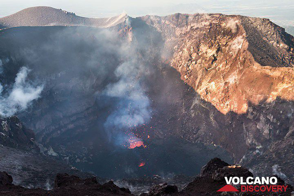 |
Figure 71. A small cinder cone with a vent 2-3 m wide is active on the floor of MacKenney Crater at the summit of Pacaya on 22 December 2015. Courtesy of Volcano Discovery (photo by Tom Pfeiffer). |
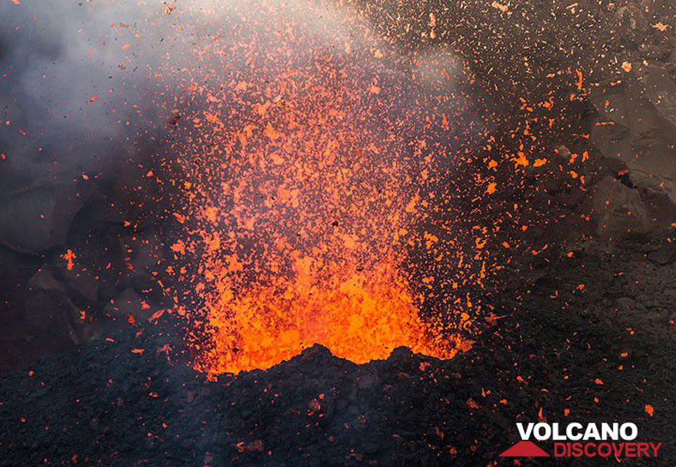 |
Figure 72. Lava bubbles inside the cinder cone at Pacaya burst into thousands of glowing fragments on 22 December 2015, building the cinder cone. Courtesy of Volcano Discovery (photo by Tom Pfeiffer). |
Activity during 2016. INSIVUMEH reported that during January 2016, Pacaya exhibited activity similar to 2015. Incandescence was visible at night during 20-27 January, and during this time a hot spot was captured at the summit in a Landsat image. A small collapse on the NW side of the inner crater generated a column of gray emissions that rose to 3 km altitude (500 m above the summit) on 20 January. A Landsat image on 12 February again showed incandescence and a steam plume rising 100 m above the crater. Incandescence reappeared on 20 February and persisted for the remainder of the month. Emissions from the main crater were primarily magmatic SO2 and steam; they generally rose 50-150 m above the crater and drifted N.
Incandescent activity at MacKenney Crater increased during March and April 2016. Landsat images showed incandescence aligned along a NW-SE trending fissure within the crater. MODVOLC thermal alert pixels appeared on 1, 19, and 26 March and again on 10 April; the 10 April thermal alert was readily visible as a hotspot in satellite imagery (figure 73). INSIVUMEH noted that the intra-crater cone continued to grow during March and April. The MIROVA Log Radiative Power data also registered a number of thermal anomalies during March and April (figure 74).
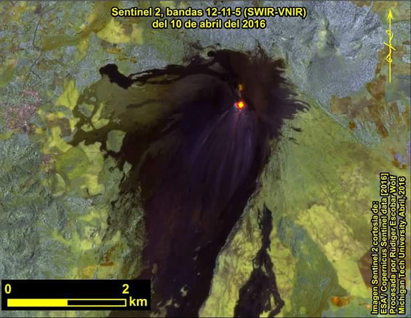 |
Figure 73. Incandescence at the MacKenney Crater at Pacaya taken with the European Space Agency's Sentinel 2 satellite on 10 April 2016. Image courtesy INSIVUMEH and ESA (Reporte Mensual, Volcan Pacaya, April 2016). |
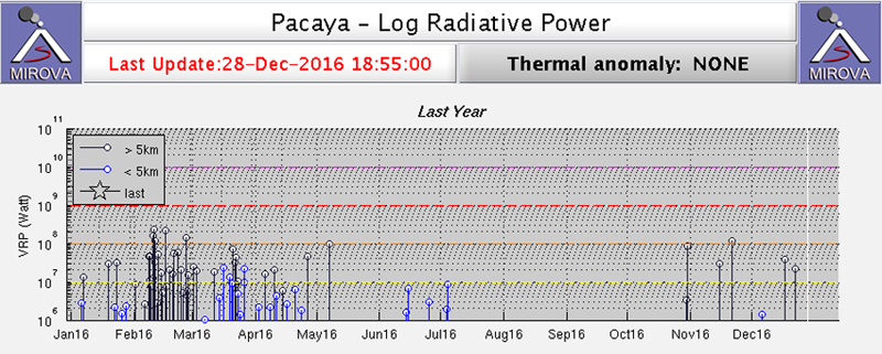 |
Figure 74. MIROVA Log Radiative Power data for Pacaya for the year ending 28 December 2016. Thermal anomalies within 5 km of the summit were reported a number of times during January-April, and again during June and July. Courtesy of MIROVA. |
During May 2016 the intra-crater cone continued to grow, and minor Strombolian activity during the night was observed regularly by INSIVUMEH. Most of the activity occurred on the N flank, with some incandescence on the W flank at the end of the month. Seismicity continued at modest levels with occasional explosions resulting from minor collapses of the crater wall. Strombolian activity increased during June, although the degassing plume did not reach more than 400 m above the crater. The webcam recorded incandescent material accumulating on the NW flank.
Seismic activity during July 2016 remained constant, caused by degassing and Strombolian explosions which were observed during 7-10 July. Material was ejected 75 m above the crater during 23-24 July. Views of Pacaya from the NW and the S during July and August revealed minor fumarolic activity from the summit as well as evidence of the extensive January-March 2014 lava flows (figures 75 and 76). Incandescence continued to be observed at night and in satellite images during July and August, with debris from the Strombolian activity concentrated on the N and NW flanks.
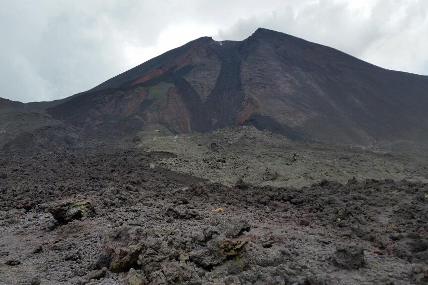 |
Figure 75. View of Pacaya on 18 July 2016 from La Meseta (the Mesa) on the NW flank showing lava flows from early 2014 and steam emissions from the summit. Courtesy of INSIVUMEH (Reporte Mensual, Volcan Pacaya, July 2016). |
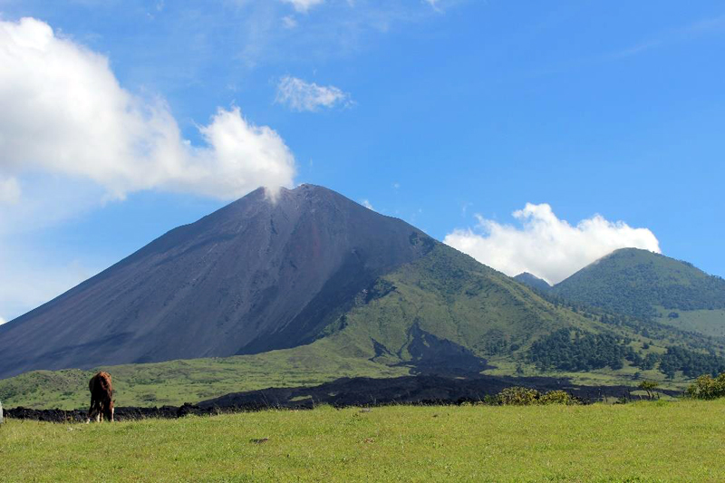 |
Figure 76. View of Pacaya from Los Pocitos, 5 km S of the summit, on 17 August 2016 showing steam plume drifting SW and part of the extensive 2014 lava flow in the foreground. Courtesy of INSIVUMEH (Report Mensual, Volcan Pacaya, August 2016). |
By October 2016, observations of incandescence at the summit were less frequent. INSIVUMEH noted that intermittent incandescence continued for the rest of 2016 with new material accumulating within MacKenney Crater. Visitors to the intra-crater cone in early December 2016 noted strong degassing of steam, magmatic gases, and possible ash, but no Strombolian activity. The intra-caldera cone was significantly larger than when observed a year earlier (figure 77).
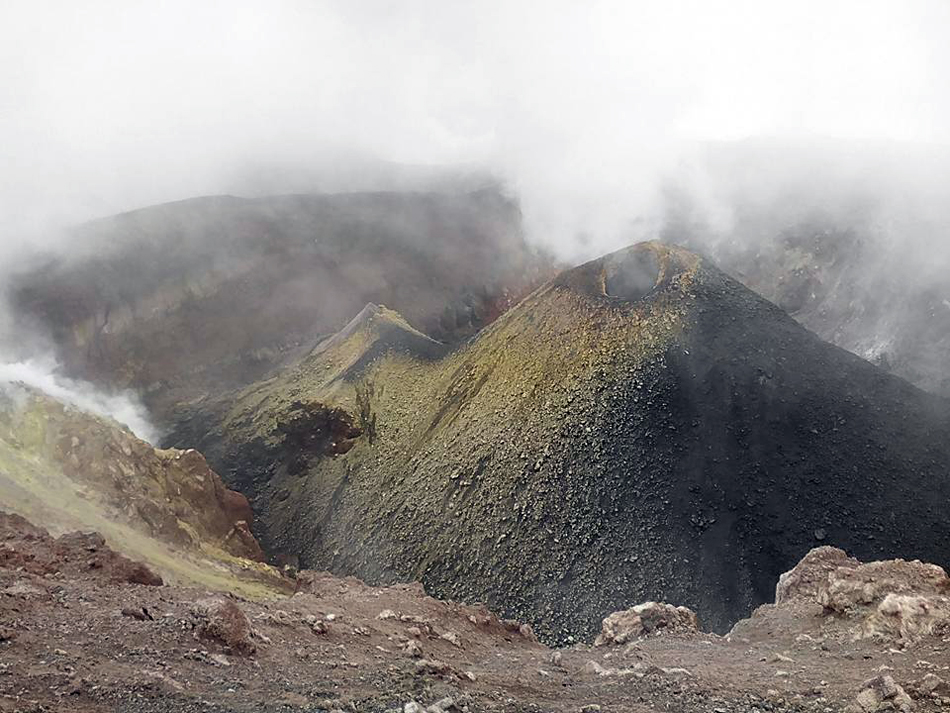 |
Figure 77. Intra-crater cone at Pacaya in early December 2016. Courtesy of Volcano Discovery (Image from Mynor Marroquin via @ClimaEnGuate / Twitter). |
Geological Summary. Eruptions from Pacaya are frequently visible from Guatemala City, the nation's capital. This complex basaltic volcano was constructed just outside the southern topographic rim of the 14 x 16 km Pleistocene Amatitlán caldera. A cluster of dacitic lava domes occupies the southern caldera floor. The post-caldera Pacaya massif includes the older Pacaya Viejo and Cerro Grande stratovolcanoes and the currently active Mackenney stratovolcano. Collapse of Pacaya Viejo between 600 and 1,500 years ago produced a debris-avalanche deposit that extends 25 km onto the Pacific coastal plain and left an arcuate scarp inside which the modern Pacaya volcano (Mackenney cone) grew. The NW-flank Cerro Chino crater was last active in the 19th century. During the past several decades, activity has consisted of frequent Strombolian eruptions with intermittent lava flow extrusion that has partially filled in the caldera moat and covered the flanks of Mackenney cone, punctuated by occasional larger explosive eruptions that partially destroy the summit.
Information Contacts: Instituto Nacional de Sismologia, Vulcanologia, Meteorologia e Hydrologia (INSIVUMEH), Unit of Volcanology, Geologic Department of Investigation and Services, 7a Av. 14-57, Zona 13, Guatemala City, Guatemala (URL: http://www.insivumeh.gob.gt/); Coordinadora Nacional para la Reducción de Desastres (CONRED), Av. Hincapié 21-72, Zona 13, Guatemala City, Guatemala (URL: http://conred.gob.gt/www/index.php); Hawai'i Institute of Geophysics and Planetology (HIGP), MODVOLC Thermal Alerts System, School of Ocean and Earth Science and Technology (SOEST), Univ. of Hawai'i, 2525 Correa Road, Honolulu, HI 96822, USA (URL: http://modis.higp.hawaii.edu/); MIROVA (Middle InfraRed Observation of Volcanic Activity), a collaborative project between the Universities of Turin and Florence (Italy) supported by the Centre for Volcanic Risk of the Italian Civil Protection Department (URL: http://www.mirovaweb.it/); European Space Agency (ESA) (URL: http://www.esa.int/ESA); Tom Pfeiffer, Volcano Discovery (URL: http://www.volcanodiscovery.com/).