Report on Tungurahua (Ecuador) — May 2017
Bulletin of the Global Volcanism Network, vol. 42, no. 5 (May 2017)
Managing Editor: Edward Venzke.
Edited by A. Elizabeth Crafford.
Tungurahua (Ecuador) Nine ash plumes over 10 km altitude 2011-2014; lava flow in April 2014
Please cite this report as:
Global Volcanism Program, 2017. Report on Tungurahua (Ecuador) (Crafford, A.E., and Venzke, E., eds.). Bulletin of the Global Volcanism Network, 42:5. Smithsonian Institution. https://doi.org/10.5479/si.GVP.BGVN201705-352080
Tungurahua
Ecuador
1.467°S, 78.442°W; summit elev. 5023 m
All times are local (unless otherwise noted)
Abundant ash emissions, Strombolian activity, pyroclastic flows, lahars, and a few lava flows have all been documented at Tungurahua, which lies in the center of Ecuador. Historic observations are recorded back to 1557, and radiocarbon dates are as old as 7750 BCE. Prior to renewed activity in 1999, the last major eruption had occurred during 1916-1918. Since 1999, there have been numerous eruptive episodes, but only a few with breaks in activity longer than three months. Our last bulletin report (BGVN 40:03) covered the first part of the eruption that began on 22 November 2010. This report details activity from November 2011 through December of 2014. Tungurahua is monitored by the Observatorio del Volcán Tungurahua (OVT) of the Instituto Geofísico (IG) of Ecuador, and aviation alerts are reported by the Washington Volcanic Ash Advisory Center (VAAC).
Summary of November 2010-December 2014 activity. After a period of quiescence from 29 July through 21 November 2010, a new eruption began with a series of ash explosions and Strombolian activity on 22 November. Explosions continued through 25 December 2010 (BGVN 40:03), and emissions containing ash continued through 2 January 2011. A new eruption with tremor and ash emissions began on 20 April 2011; explosions with substantial ash plumes occurred on 22 April. Strombolian activity was frequent, and ashfall affected numerous communities within 10 km for the next five weeks. This episode ended with explosions and ash plumes on 21 May (BGVN 40:03), followed by ashfall reported to the SW through 26 May 2011. After damaging lahars at the end of May, Tungurahua was quiet until November 2011.
Volcanic activity between November 2011 and December 2014 occurred in eight discrete episodes (table 19). The length of these episodes ranged from 3 weeks to 9 months, and the lengths of the breaks between them lasted from 4 weeks to 3 months. Ash plumes rising several kilometers above the 5-km-high summit and ashfall in communities tens of kilometers from the volcano characterized each episode. Strombolian activity also sent incandescent blocks down the flanks hundreds of meters, pyroclastic flows traveled several kilometers down the ravines, and lahars during the wet seasons flooded drainages and frequently damaged roadways. A lava flow several hundred meters long descended the upper W flank in April 2014.
Table 19. Episodes of activity at Tungurahua, November 2011 through December 2014. These episodes are based on reported activity as described in this report, and may not correspond to current or previous "Eruptive Episodes" identified by IG.
| Episode Start | Episode Stop | Approx. Duration | Following Interval of Repose |
| 27 Nov 2011 | 4 Sep 2012 | 40 weeks | 12 weeks |
| 14 Dec 2012 | 24 Jan 2013 | 7 weeks | 5 weeks |
| 01 Mar 2013 | 24 Mar 2013 | 3 weeks | 4 weeks |
| 24 Apr 2013 | 15 May 2013 | 3 weeks | 8 weeks |
| 13 Jul 2013 | 23 Aug 2013 | 6 weeks | 6 weeks |
| 06 Oct 2013 | 12 Nov 2013 | 5 weeks | 11 weeks |
| 30 Jan 2014 | 11 May 2014 | 14 weeks | 11 weeks |
| 17 Jul 2014 | 15 Dec 2014 | 20 weeks | -- |
Hundreds of ash plumes were emitted over this time period. Nine times, the ash plumes were recorded at altitudes over 10 km (more than 5 km above the summit) (table 20), with the highest on 4 April 2014 rising to 15.2 km altitude (50,000 ft).
Table 20. Ash plumes over 10 km altitude recorded at Tungurahua between November 2011 and December 2014.
| Date (local) | Altitude (km) | Drift direction(s) | Distance (km) |
| 27 Nov 2011 | 10.7 | WNW | 100 |
| 03 Dec 2011 | 11.0 | SW | 110 |
| 22 Dec 2011 | 12.2 | NE | -- |
| 04 Feb 2012 | 12.2 | NE | 250 |
| 11 Apr 2012 | 10.7 | NE, W, SE | 170 |
| 16 Dec 2012 | 12.2 | NW, NE | 140 |
| 14 Jul 2013 | 13.7 | NNE, WNW | 370 |
| 01 Feb 2014 | 13.7 | S, SW | -- |
| 04 Apr 2014 | 15.2 | NW, N, NE | 300 |
Activity during May 2011-September 2012. After loud explosions and ash emissions on 21 May 2011, constant rains at the end of May caused lahars and muddy water to descend the ravines of Tungurahua (BGVN 40:03). Ashfall was reported on 26 May, although cloud cover prevented observations of plumes. No further ash emissions or thermal anomalies were confirmed for six months. The Washington VAAC issued a volcanic ash advisory on 7 October based on a report from IG, and two additional reports on 24 October and 9 November from pilot reports. They noted that no ash was visible in satellite imagery at the time of those reports; on 9 November a revised statement from IG stated that no ash emissions had occurred since June.
A new eruption began on 27 November 2011, when three large explosions generated pyroclastic flows and caused ashfall within 10 km in several communities. Ashfall was reported in El Manzano (8 km SW), Bilbao (8 km W), Pailitas (8 km W), Cotaló (8 km NW), and Cusúa (8 km NW) (figure 62). The first Washington VAAC reports after these explosions noted an ash plume at 10.7 km altitude (5.7 km above the summit crater) drifting WNW and extending about 100 km from the summit.
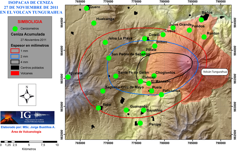 |
Figure 62. Isopach map of ashfall accumulation around Tungurahua on 27 November 2011. Courtesy of IG (Resumen Mensual, Actividad del Volcan Tungurahua, November 2011). |
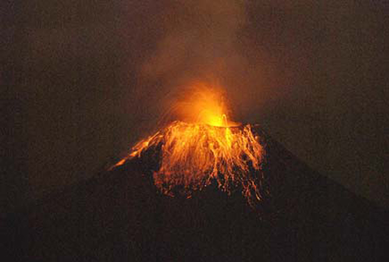
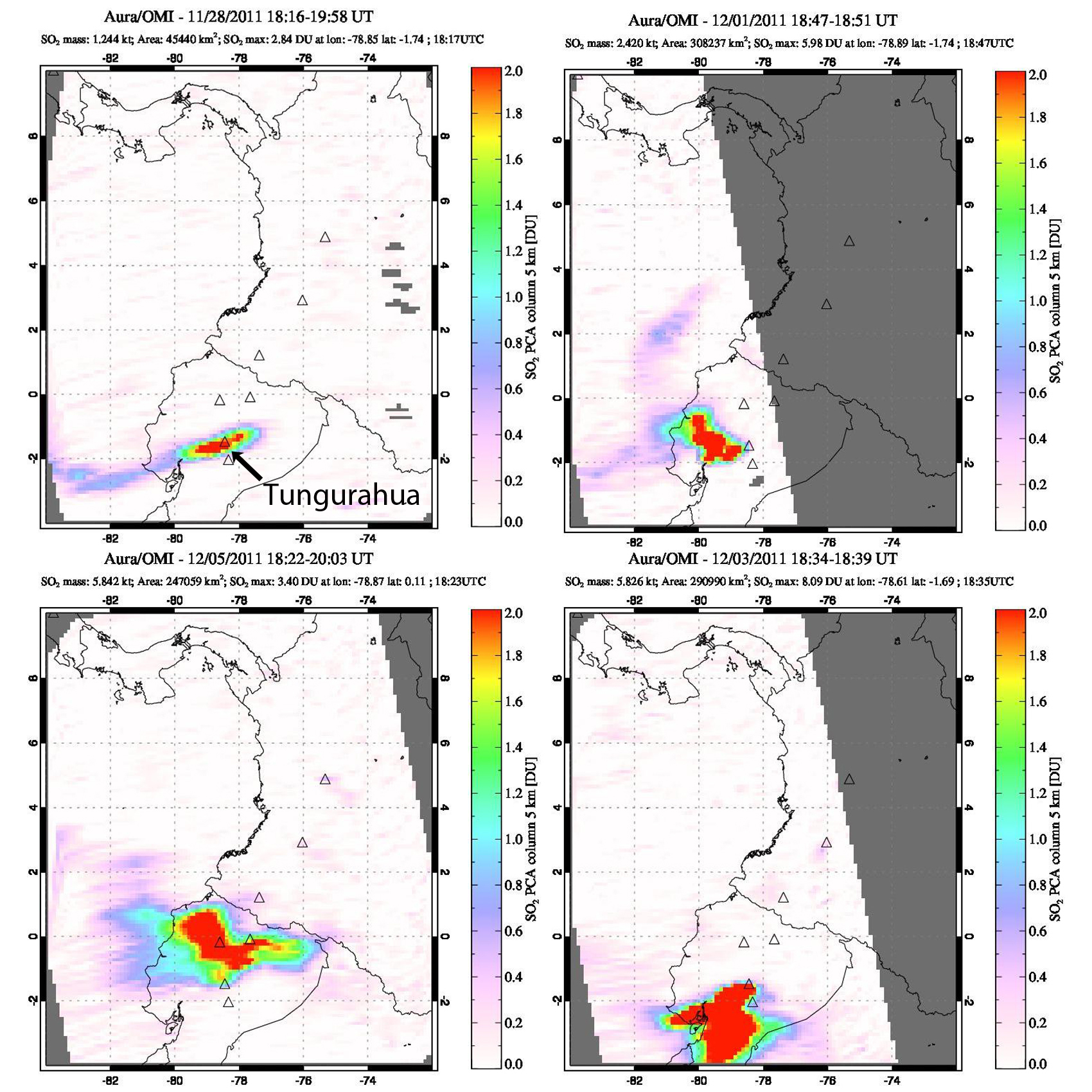
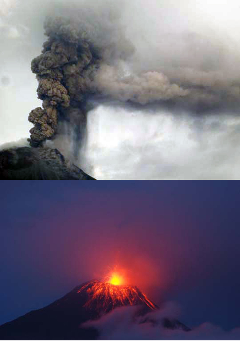
During the next three weeks, nearly constant ash emissions with plumes as high as 11 km altitude (3 December) deposited ashfall in numerous communities. In addition to those communities mentioned above, Choglontús (13 WSW), Chacauco (17 km NW), Cahuají 8 km SW), Baños (9 km N), and Vazcún also received ashfall during this period. Many residents in Cusúa, Juive (8 km NNW), Palitahua (6 km SSW), and El Manzano evacuated voluntarily. Strombolian activity sent large incandescent blocks 500 m above the crater and 1,000 m down the flanks (figure 63), and pyroclastic flows traveled as far as 2 km down the flanks (BGVN 40:03). MODVOLC thermal alerts were issued on 1 and 4 December. Substantial plumes of SO2 were recorded by NASA's Global Sulfur Dioxide Monitoring system between 28 November and 8 December (figure 64).
Another major explosion on 22 December sent ash plumes to 12.2 km (7.2 km above the summit), according to the Washington VAAC. Emissions continued through 28 December. Ashfall from explosions near the end of December accumulated to a depth of 2-4 mm in villages to the SW. After two weeks of quiet, with only steam plumes emitting from the summit, a series of explosions between 12 and 15 January 2012 caused ashfall in communities up to 10 km SW. Ash plumes reported by IG rose to 7 km altitude; weather clouds often prevented satellite observations. Three lahars occurred during this time; one descended the Achupashal drainage on the NW flank carrying blocks up to 1 m in diameter, and the other two descended the Juive and Pondoa drainiages farther N on the NW flank, carrying blocks 10-20 cm in diameter. Another lahar on 21 January traveled down the Pampas drainage.
A large explosion on 4 February 2012, with an ash plume reported by the Washington VAAC at 12.2 km altitude, caused lapilli and ash to fall in communities as far away as Cevallos (23 km NW). Ongoing emissions were reported five hours later; the ash cloud was observed 250 km NE near the Ecuador-Colombia border. A pyroclastic flow also descended the Achupashal drainage, and incandescent blocks traveled 1 km down the flanks. Ash plumes during 17-18 February were reported by IG to rise to 6 km altitude, although weather clouds obscured satellite images. From 23 February to 13 March, numerous ash plumes caused ashfall in most communities NW and SW of the volcano, as far as Choglontus (13 km WSW). The Washington VAAC and IG both reported plumes as high as 8.5 km altitude (3.5 km above the summit crater) drifting W and SW during this time. Strombolian activity ejected material 500 m above the crater and onto the W and NW flanks on 24 February, and another pyroclastic flow was observed in the Achupashal drainage on 4 March. Lahars descended the Chacauco (NW) and Mapayacu (SW) drainages on 11 March.
After a short break, explosions were again detected on 19 March 2012. During brief periods when the crater was visible, observers noted incandescence and a few blocks rolling 200 m down the flank. A single MODVOLC thermal alert pixel was recorded on 20 March. IG and the Washington VAAC reported numerous ash plumes between 20 and 29 March, although weather clouds and precipitation made observations difficult for much of the month. Ashfall was reported in the villages within 10 km in most directions. Heavy rain during 24-25 March generated lahars in the Pampas area to the S and caused flooding in the Puela (8 km SW), Palitahua, and Ulba (10 km NNE) sectors. Additional lahars on 1 April descended the Pingullo and Achupashal (NW) drainages, carrying material 30 cm in diameter and causing a temporary road closure.
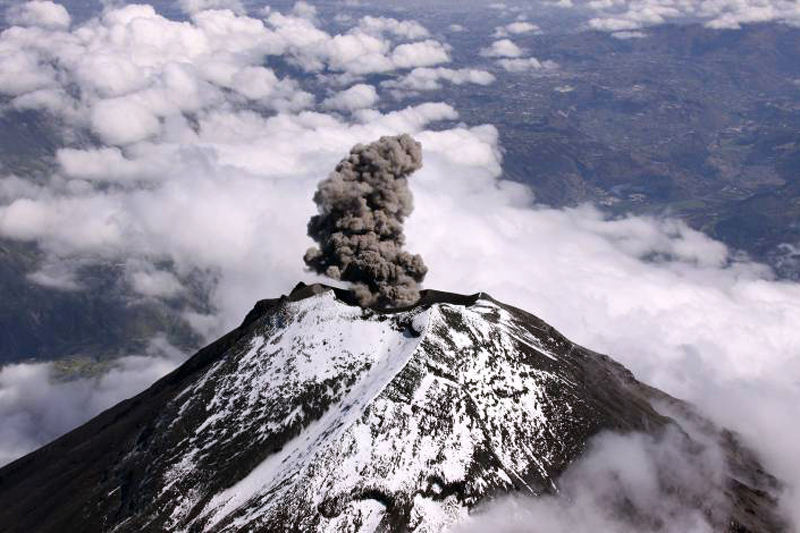
Persistent ash emissions rising to 8 km altitude and higher began again on 9 April 2012, and occurred with few breaks until mid-June when they became more intermittent. Ashfall was commonly reported from villages within 10 km during this period. A large plume on 11 April was reported by the Washington VAAC at over 10 km altitude drifting NE and SE (figure 65); rice-sized tephra fell in Pillate (7 km W) on 22 April. Ashfall covered houses and pastures in Bilbao and Pillate on 6 May. Several plumes in early June (3, 5, 10, 11, 13) resulted in ashfall, with noise and vibrations noted, within 10 km. IG staff witnessed an ash emission on 4 June (during an overflight) that rose about 1 km above the crater and drifted E (figure 66). Numerous lahars descended drainages on the W and SW flanks in late April, and again down the W flank on 16 May. On 7 June a lahar caused a temporary closure of the Baños-Penipe highway. Smaller lahars were reported in the same area on 24 June.
After an explosion on 27 June 2012 generated an ash plume that rose to 3 km above the crater, only small intermittent explosions with ash plumes occurred during July; steam-and-gas plumes rising up to 1 km above the summit were more common (figure 67). Incandescence at the summit and small explosions were noted on 25 July, and a few days later muddy waters carried blocks 50 cm in diameter down several S and W flank drainages. Surface and seismic activity increased noticeably during the last week of July.
Explosions on 5 August 2012 rattled windows in nearby areas and produced sounds resembling gunshots. A plume rose 3 km above the crater and drifted W. Several periods of continuous ash emissions occurred during the rest of the month; ashfall was reported in villages within 10 km many times. Incandescent blocks that were ejected 100 m above the crater fell 500 m down the flanks on 12-13 August. Activity significantly increased with strong explosions on 17 August. The next day, five small pyroclastic flows descended the NW and NE flanks, stopping 2.5 km from the crater. Numerous explosions continued on 19 and 20 August, with steam-and-ash plumes rising 1.5-2 km above the summit and drifting W and SW. Ash fell in communities farther to the NW than in previous months, including in Igualata (20 km W), El Santuario, Hualpamba, Cevallos (23 km NW), Quero (20 km NW), Mocha (25 km WNW), Santa Anita, and Tisaleo (29 km NW). IG scientists determined that an approximate volume of 400-500,000 cubic meters of ash was deposited within 15 km of the volcano between 10 and 20 August. The maximum deposit thicknesses were 3 mm in Yuibug, 2 mm in Pillate, 1.5 mm in Choglontús and Chontapamba, 1 mm in Cahuají, and 0.5 mm in Puela (figure 68).
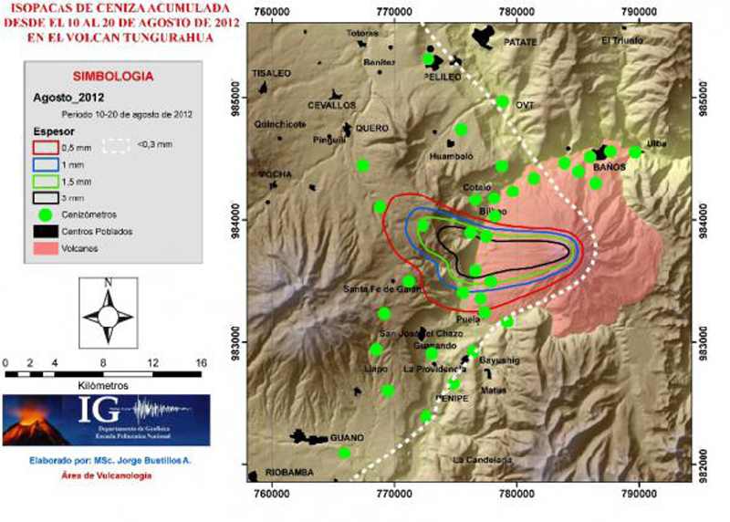 |
Figure 68. Isopach map of ashfall accumulation around Tungurahua during 10-20 August 2012. Courtesy of IG (Boletín Especial del Volcán Tungurahua No. 4, 25 Aug 2012). |
An overflight on 20 August revealed an 80-m-wide inner crater. On 21 August, 16 large explosions caused windows to rattle. Strong "cannon shots" were heard in areas as far away as Ambato (31 km NW) and Riobamba (30 km S), although noises had decreased in intensity and duration compared to the previous few days. Ash plumes rose as high as 9.7 km altitude and drifted W, and a pyroclastic flow traveled 2.5 km down the NW flank that day. MODVOLC thermal alert pixels appeared during 16-23 August. Explosions and ash plumes rising up to 4 km above the crater continued for the rest of August, along with ejected incandescent tephra and ashfall in nearby communities. IG reported that the intensity of seismic tremor and emissions decreased beginning on 21 August.
NASA's Global Sulfur Dioxide Monitoring system captured SO2 plumes during 13-21 August, and again from 31 August to 3 September. An explosion on 3 September produced an ash plume that rose 300 m above the crater; two MODVOLC thermal alerts also appeared that day. A final ash plume was reported by IG on 4 September rising to 6.7 km altitude (1.7 km above the summit), but dense cloud cover prevented satellite observation. No more ash plumes were reported until 14 December 2012.
Activity during December 2012-January 2013. A major rainfall event on 1 December generated a large lahar that descended the Vazcún drainage on the N flank, causing an evacuation of people at the El Salado resort (8 km N) before the 6-m-deep lahar that carried 3-m-diameter blocks reached the area. An increase in seismicity beginning on 12 December preceded a large explosion on 14 December. The explosion created an ash plume, identified in satellite imagery by the Washington VAAC, that rose to 7.9 km altitude. The leading edge of the 10-km-wide, detached plume was 15 km SE of the summit. Pyroclastic flows traveled down the SW flank. A smaller ash plume the next day caused a trace of ashfall in Runtún (6 km NNE).
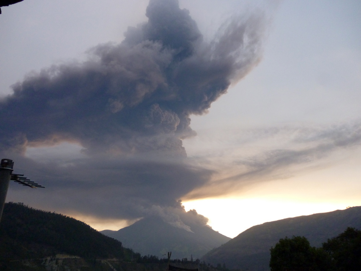
Three large explosions on 16 December 2012 ejected incandescent blocks and expelled an ash plume, containing lightning, that rose to 12.2 km altitude (7.2 km above the summit) (figure 69). The soundwaves from the explosion reportedly broke the windows of the church of Cusúa. The Washington VAAC identified the plume in satellite imagery extending up to 140 km NW, and 110 km NE at a lower altitude of 7.9 km. Ashfall was reported up to 31 km NW from Tungurahua, in Cotaló (8 km NW), Pondoa (8 km N), Runtún, and Pillate (8 km W). More specifically, coarse-grained ash fell in Baños (9 km N), Vascún, and Ulba (NNE), and medium-to-fine-grained ash fell in Palitahua (S), Choglontús (SW), El Manzano (8 km SW), Capil, Guadalupe Observatory (13 km N), Cevallos (23 km NW), Tisaleo (29 km NW), Ambato (31 km NW), Patate (NW), Píllaro, Pelileo (8 km N), Salcedo, and Pujilí, Latacunga, Rio Verde, Agoyán, and Palora.
Explosions and ashfall continued on 17 December; a dense ash plume was observed drifting over 200 km NE at an altitude of 7 km. A seven-pixel MODVOLC thermal alert also appeared. Substantial SO2 plumes were recorded by the OMI satellite instrument between 16 and 29 December. Two pyroclastic flows traveled 3-4 km down the flanks and burned vegetation on 18 December. Explosions shook structures, were often heard by local residents, and generated ashfall in the neighboring communities for several days. The following week, ash plumes decreased in frequency and density, but explosions of incandescent blocks increased. During 21-24 December Strombolian explosions appeared at night; they peaked at over 500 m above the crater, sending blocks more than one kilometer down the W and NW flanks. On the night of 23 December, observers noted intermittent lava fountains rising to 500 m. Another MODVOLC thermal alert pixel was recorded on 24 December. After this, seismicity decreased significantly; the Washington VAAC last reported emissions on 30 December.
Trace amounts of ashfall were reported by IG on 6 and 10 January 2013 in Choglontús (SW) and El Manzano (8 km SW), after small explosions on those days. Explosions, but no ash, were recorded on 21 January; in the evening of 24 January, a column of steam and gas with very low ash content rose less than 1 km and drifted W and SW after reported explosions. The lookout at Palitahua reported black ashfall the following morning. After this, Tungurahua was quiet until the end of February 2013.
Activity during March 2013. IG reported increased seismicity on 28 February 2013. Explosions occurred, and ash emissions rose a few hundred meters above the crater the next day. Ashfall was reported in areas on the SW flank including Choglontús and El Manzano. Multiple VAAC reports were issued daily from 1 to 18 March. Ash plume heights were generally 1-1.5 km above the summit crater (6-6.5 km altitude), but were reported 4 km above the crater on 17 March. Several times during March, IG reported incandescent blocks rolling as far as 500 m down the flanks, and repeated ashfall in communities within 15 km (figure 70). Deformation measurements suggested that a small magma body was rising beneath the NW flank. An SO2 plume first appeared in the OMI satellite data on 2 March, and was visible daily until 12 March. From 10 to 15 March, MODVOLC recorded 15 thermal alert pixels. Pyroclastic flows occurred on 15 and 17 March; lava fountains rose 200-300 m above the crater on 17 March. A notable decline in seismicity began on 21 March, and a low-ash-content plume that rose 1 km above the crater on 24 March was the last ash emission until the end of April.
Activity during April-May 2013. The webcam confirmed the minor emission of volcanic ash on 24 April 2013; the Washington VAAC reported an ash plume at 6.7 km altitude extending 50 km WNW from the summit on the same day. A series of large explosions began on 27 April. During the next week, these explosions sent steam-and-ash plumes up to 4.7 km above the summit (9.7 km altitude) which drifted at least 100 km SW and W. Ash plumes reported daily by the Washington VAAC rose 1-3 km above the summit until 15 May, and ash fell in communities across the region up to 30 km away in many directions. Lahars traveled down drainages on the S, N, and NW flanks on 4 May. A pyroclastic flow traveled 2 km down the NW flank on 5 May, and Strombolian activity was visible on most nights. During 9-10 May, lava fountains rose 700 m above the crater. MODVOLC thermal alert pixels appeared on 1, 10, 12, and 13 May. An SO2 plume was recorded in the OMI satellite data on 29 and 30 April, and again from 5 to 12 May. After a slight amount of ash was reported in Choglontus (SW) on 15 May, there were no more reports of ash plumes for two months.
Activity during July-August 2013. IG reported increased seismicity on 13 July 2012 in advance of two large explosions on the morning of 14 July; the first was heard in areas as far away as Guayaquil (about 180 km SW). The Washington VAAC reported the plume from these explosions at 13.7 km altitude (8.7 km above the summit) around midday. They noted that satellite imagery showed a dense ash plume expanding in all directions from the summit, but moving generally N and W. Significant amounts of tephra fell in areas near the volcano including Bilbao (4-cm-diameter), Chacauco (5-cm-diameter), Cotaló, Cahuají, Choglontus, El Manzano, Puela, and Penipe (15 km SW). Thinner deposits were reported in towns including Pelileo, Ambato, Cevallos, Colta (45 km SW), Guanujo (65 km WSW), and Guaranda (65 km WSW), and in the cantons of Guano (30 km SW), Valencia, Empalme, Buena Fé, and areas in the province of Manabi (180 km NW).
Several significant pyroclastic flows also descended drainages on the NW flanks, including the Achupashal and Juive Grande drainages, during the explosions of 14 July. The pyroclastic flows at Juive Grande reached a distance of 6.3 km and stopped a kilometer above the road (figure 71). The temperature measured in the deposit with a thermal camera the next day was 95°C. In the Achupashal stream, the pyroclastic flows reached 6.5 km and crossed the Chambo River. The temperature measured in this deposit was 65°C. According to USA Today, over 200 people were evacuated from Cusua, Chacauco, and Juive.
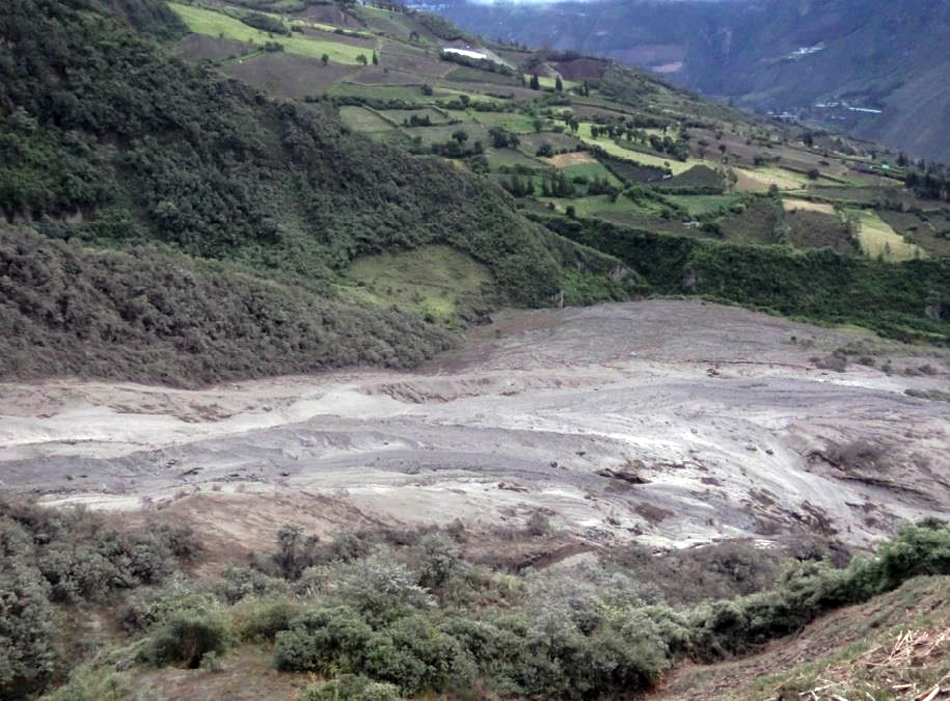 |
Figure 71. Pyroclastic flow deposit from Tungurahua in the Juive Grande ravine, 14 July 2013. Courtesy of IG; photo by P. Mothes, IG-EPN (Informe Especial del Volcán Tungurahua No. 15, 16 July 2013). |
Volcanic ash advisories were issued daily by the Washington VAAC until 1 August 2013. IG reported that on 19 July the geodetic monitoring system indicated an inflationary trend on the N flank and deflation SW of the volcano, a continuing indication of the presence of a magma body about 2 km below the crater. Ash fell in communities up to 30 km away several times during the period, including after large plumes that rose to 9.6 and 9.9 km altitude on 21 and 24 July. Minor amounts of ash were reported in the Guaranda, Salinas, and Guanujo (65 km WSW) areas after explosions on 26 July, one of which also generated a small pyroclastic flow. Strombolian activity occurred throughout the period, with activity including incandescent blocks rolling up to 500 m down the flanks several times. The OMI instrument captured SO2 plumes from 15 July through 2 August. MODVOLC thermal alerts were issued on 27 and 29 July. Seismic and explosive activity decreased during the first week in August. An ash plume on 8 August that rose 2 km above the summit and drifted W caused minor ashfall in Choglontus (SW). Trace ashfall was reported in Choglontús and El Manzano on 23 August.
Activity during October-November 2013. Activity resumed in early October 2013 with increased seismicity, Strombolian activity, ash plumes, and pyroclastic flows. A small explosion on 6 October produced ashfall in nearby areas. A larger high-level ash plume on 11 October was observed by the Washington VAAC rising to 8.5 km altitude; ashfall spread to nearby towns. Pyroclastic flows were reported on 14 October. Daily VAAC reports that began on 11 October continued through 30 October, followed by reports on 3, 7, and 9 November. The near-continuous ash emissions during this time generally rose 2-4 km above the crater, and deposited ash in communities within 30 km. Daily SO2 plumes were captured by OMI between 7 and 22 October, and eight MODVOLC thermal alerts appeared between 19 and 24 October. The last reports of ashfall during this episode were on 12 November when plumes rose 1.5 km from the summit and drifted W, with ashfall reported in El Manzano.
Activity during January-May 2014. The community of Pungal, 40 km SSW of Tungurahua, received ashfall on 30 January from a series of explosions that began after two and a half months of quiet. The Washington VAAC reported the ash plume visible at 8.2 km altitude extending 11 km ESE from the summit. A swarm of VT earthquakes on 1 February was followed by two explosions that generated ash plumes to 2-4 km above the summit, and pyroclastic flows that traveled 500 m down the NE and NW flanks. These explosions were followed a few minutes later by a larger explosion that produced an ash plume reported by IG that rose more than 8 km above the summit (figure 72).
Based on reports from IG, satellite images, pilot observations, web-camera images, and the Guayaquil MWO, the Washington VAAC reported that the ash plume from the 1 February explosions rose to an estimated altitude of 13.7 km, and drifted S at high altitudes and SW at lower altitudes. IG noted that pyroclastic flows traveled 7-8 km, reaching the base of the volcano and crossing over the Achupashal Baños- Penipe highway. Continuous ash-and-gas emissions followed; ash fell in multiple areas and total darkness was reported in Chacauco (NW). Explosions continued every minute and vibrated structures in local towns. Pyroclastic flows descended the SW, W, NW, and NE flanks, but stopped short of towns and infrastructure. Ash emissions were sustained through the rest of the evening, and Strombolian explosions ejected incandescent blocks 800 m above the crater that fell and rolled 500 m down the flanks.
Numerous explosions and ashfall continued in subsequent days; on 3 February 2014 an ash plume rose 4 km above the summit and drifted N, reaching Quito (130 km N) as a mist of suspended very fine material that lingered most of the day. The Washington VAAC issued multiple daily reports of ash plumes from 30 January until 23 February. An eight-pixel thermal alert on 2 February was the beginning of a sequence of MODVOLC thermal alerts that included 10 more during February. SO2 plumes drifting W were captured by the OMI satellite instrument between 7 and 10 February. During 16-18 February, ash plumes again rose to altitudes between 9 and 10 km, dispersing ash to the W and NW. Strombolian activity and loud noises were common during this interval.
Fewer ash plumes were reported during March 2014, at generally lower heights of 1-3 km above the crater; ash fell in communities within 15 km. Only three MODVOLC thermal alerts were recorded: two on 6 March and one on 15 March. On 11 and 21 March rains caused major lahars in the Achupashal drainage which led to traffic disruption on the Baños- Penipe highway. Lahars on 31 March traveled down the Vascún (N) and Mapayacu (SW) drainages, carrying blocks up to 1 m in diameter in the latter drainage.
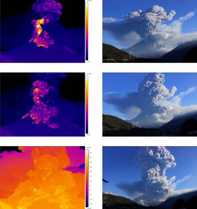
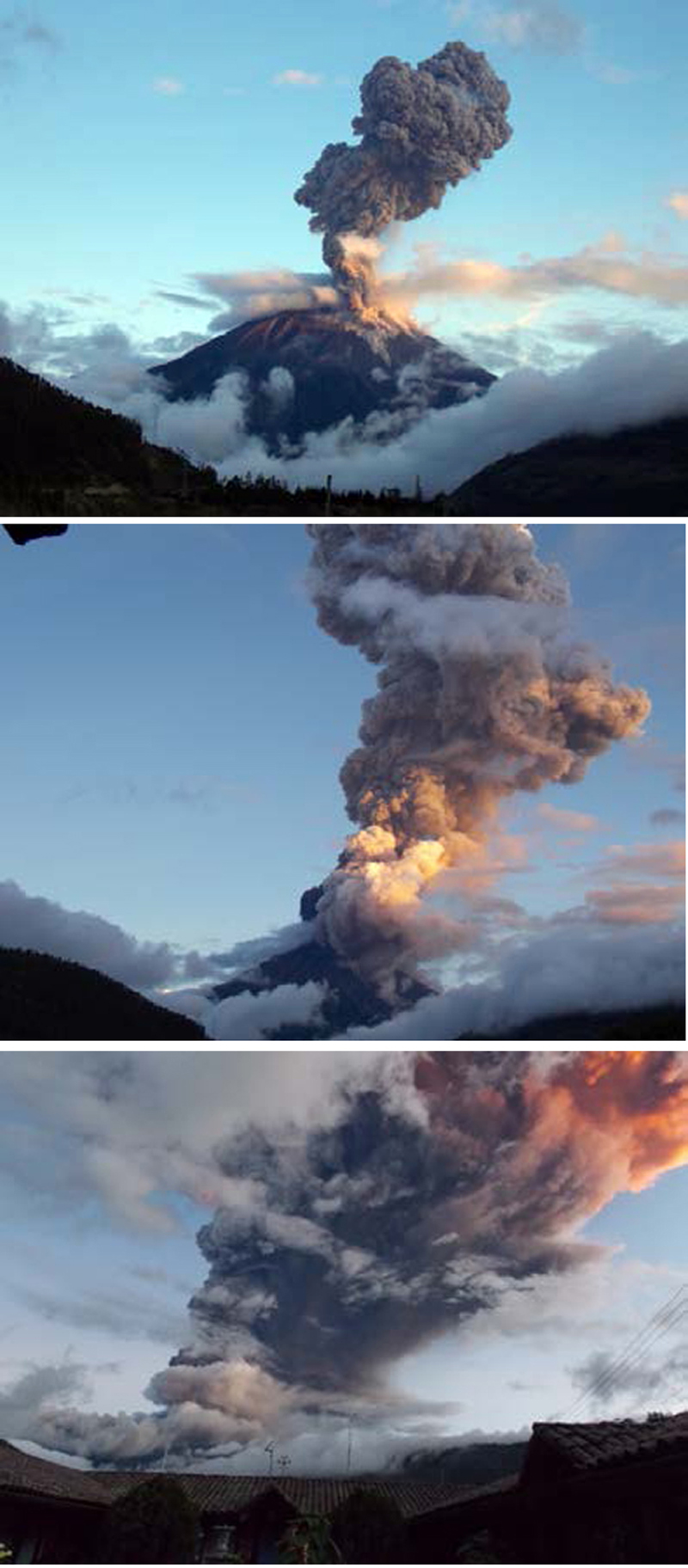
Explosions and substantial ash plumes increased in April 2014, with multiple daily VAAC reports issued between 2 and 25 April. The largest explosion, on 4 April, lasted five minutes, and generated pyroclastic flows that descended the NW and N flanks. It also caused an ash plume that rose over 10 km above the crater, reported at 15.2 km altitude (50,000 ft) by the Washington VAAC, the highest reported in many years (figure 73). Tephra up to 7 cm in diameter fell in Cusúa and Píllaro.
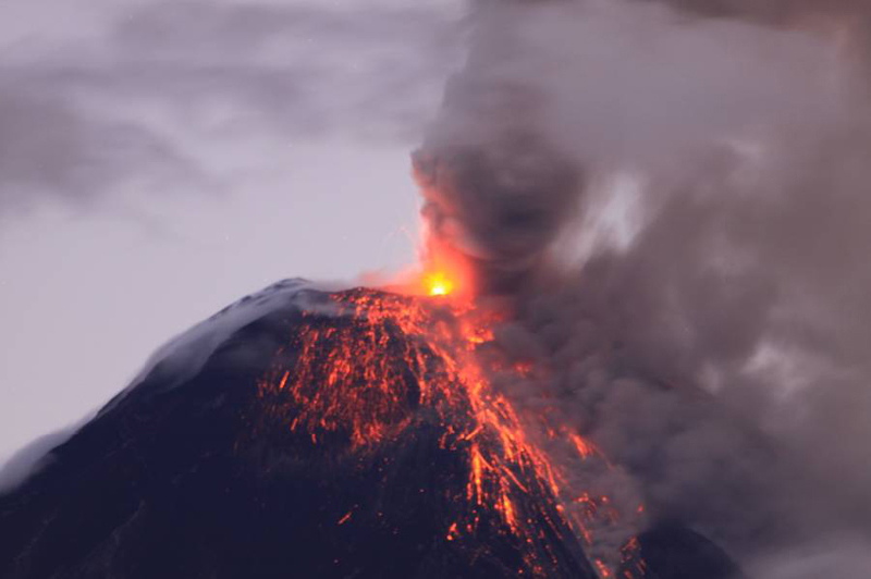
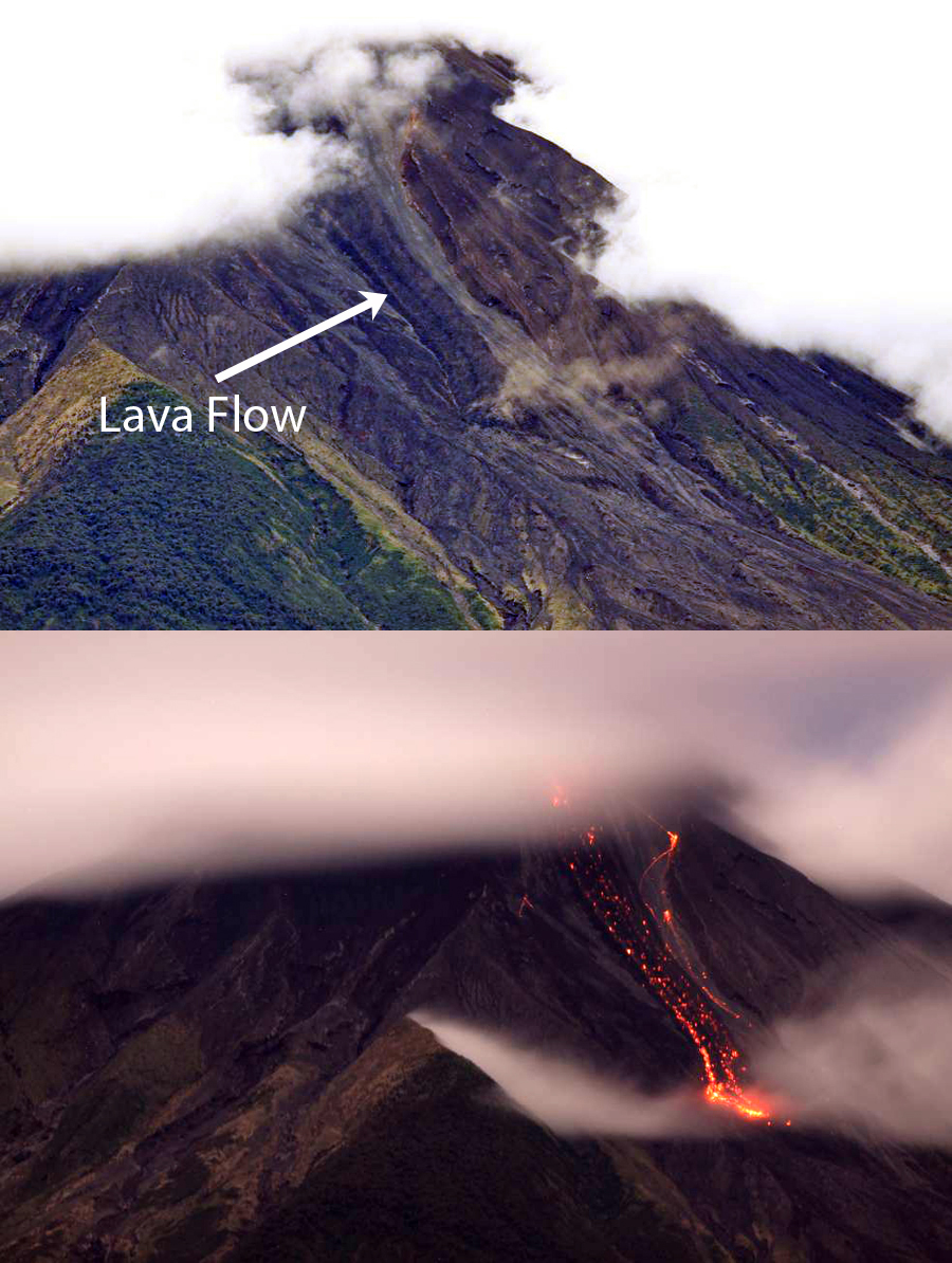
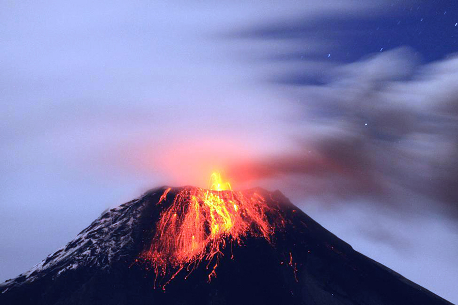
During 5-11 April, SO2 plumes drifting W were detected by the OMI satellite instrument. Large lahars descended the Achupashal (NW) and Confesionario drainages (WSW) on 8 April. On 9 April Strombolian activity caused incandescent blocks to roll 3 km down the flanks (figure 74). The next day a lava flow on the upper W flank, in the Mandur drainage, was estimated to be 2 km long, 100 m wide, and 15 m thick (figure 75). This was likely the cause of the six MODVOLC thermal alerts recorded on 11 April.
A significant explosion on 14 April 2014 produced an infrasound signal that was detected at 150 decibels 5.5 km away. Unconfirmed reports indicated that windows in Chacauco and Cusúa shattered. The shock wave was also detected in other locations, including Ambato and Riobamba (30 km S). Although IG reported an ash plume rising to over 5 km above the crater (10 km altitude), the Washington VAAC only reported the plume to 8.5 km. A lahar in the Achupashal drainage on 15 April affected traffic on the main highway. Repeated ashfall was reported for the rest of the month in communities within 30 km; crater incandescence was often observed at night.
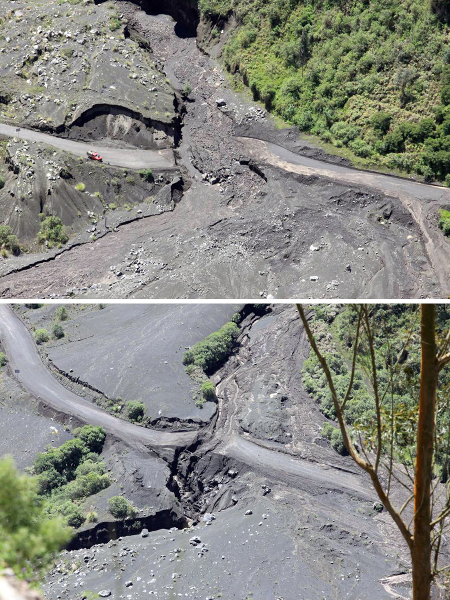
OVT reported a gas-and-ash emission to an estimated 9 km altitude on 8 May 2014. Three explosions on 10 May generated ash emissions that rose an estimated 5 km above the crater, with ashfall reported in the communities to the SW. There were no VAAC reports issued for the 10 May explosions. A small plume on 11 May had minor amounts of ash. After this, there were no further reports of ash until the end of July. Intense rains on 10 and 11 May caused lahars to flow down most drainages, and roads crossing the Chontapamba and Romero gorges were washed out (figure 76).
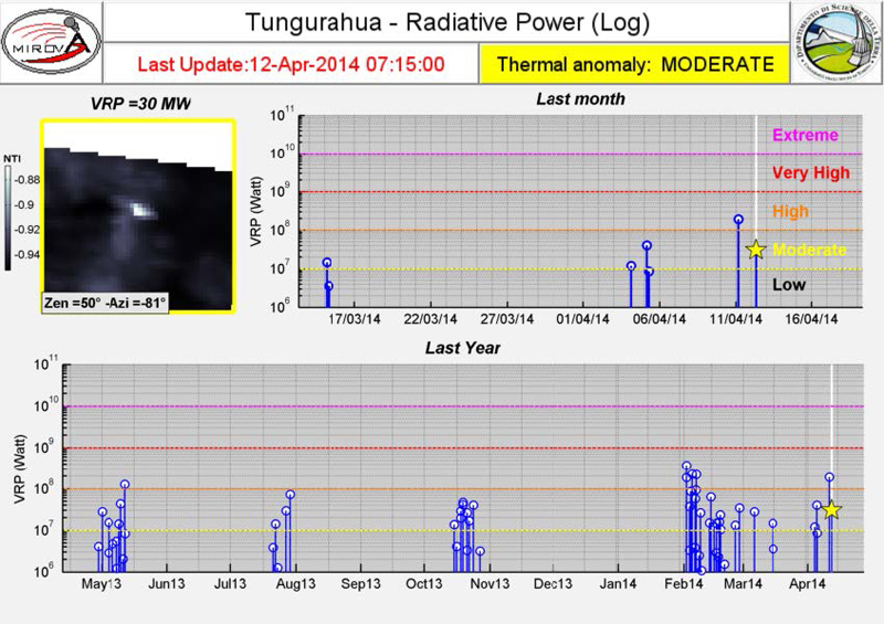
The episodic nature of the activity at Tungurahua is demonstrated well by the plot of MIROVA thermal anomaly data captured between April 2013 and April 2014 (figure 77). While the whole duration of the episode is seldom recorded due to weather and other factors, each set of anomalies based on MODIS satellite data is within the boundaries of each episode listed in table 19.
Activity during June-December 2014. Seasonal rains in June and July 2014 generated numerous lahars, some causing major damage to roads. Otherwise, the volcano was largely quiet with only 100-m-high steam plumes rising from the summit crater on clear days, until seismicity increased once again on 27 July. The seismicity was accompanied by a small ash plume that rose 1 km above the crater and drifted NW. This event was the beginning of a lengthy episode of explosions, ash plumes, Strombolian activity, pyroclastic flows, and lahars that lasted through most of December 2014.
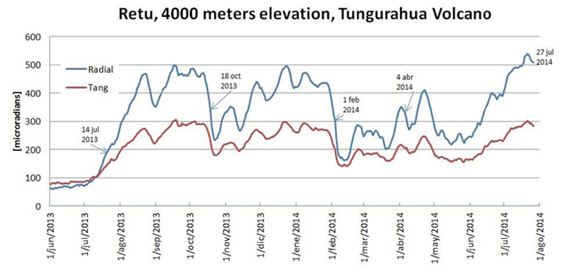
Deformation data revealed additional information about the the activity at Tungurahua (figure 78). The inclinometer of the RETU station is located on the NNE flank at an elevation of 4,000 m. During a 14-month period from 1 June 2013 to 1 August 2014 the radial axis inflation and deflation correlated with four significant explosion events. Periods of gradual inflation were followed by sudden deflation that accompanied an explosion. A new series of explosions began shortly after 24 July 2014 when the last deflation on the graph was detected.
Seismicity increased on 28 July 2014; a small explosion with an ash plume rose 1 km above the crater and drifted NW with ashfall reported in the Chontapamba area. The Washington VAAC issued multiple daily reports of ash plumes between 1 August and 11 September 2014. They were generally reported at 1-4 km above the summit, or to altitudes of 6-9 km. Ashfall was reported a number of times in communities within 30 km. Strombolian activity sent incandescent blocks as high as 1 km above the crater and up to 1.5 km down the flanks (figure 79). Incandescence appeared on most clear nights. Lahars occurred after rainy episodes during 8-9 and 13 August. On 30 and 31 August, near-constant explosions were detected, and pyroclastic flows traveled 1,500 m down the NW flank. The pyroclastic flows surrounded the lava flow from April 2014, in the La Hacienda, Achupashal, and Mandur drainages. Another pyroclastic flow reported on 3 September descended 500 m from the crater. During 10 August and 7 September, 12 MODVOLC thermal alerts were issued. SO2 plumes reappeared on the OMI satellite instrument on 2 August and were captured daily until 6 September.
Activity decreased slightly toward the end of September 2014, although intermittent ash plumes were still reported as high as 2.5 km above the crater; ashfall was recorded in communities up to 25 km away, generally to the W. Rains on 12 and 14 September resulted in lahars within the NW drainages of Achupashal and La Pampa. LP seismic events increased slightly at the end of September along with several low-level ash plumes. The last reports of nighttime incandescence were on 27 September.
Emissions with low to moderate ash content were noted most days in early October. Ashfall was reported from a few communities within 30 km on 1, 3, and 6 October. Trace amounts of ashfall appeared on the SW flank the following week. OVT reported emissions with moderate ash content rising 2-3 km above the summit during 19 and 20 October. Plumes rising to 2 km with low ash content were observed on 25 October. During the end of October and the first few days of November, IG observed only water vapor emissions to 500 m above the crater.
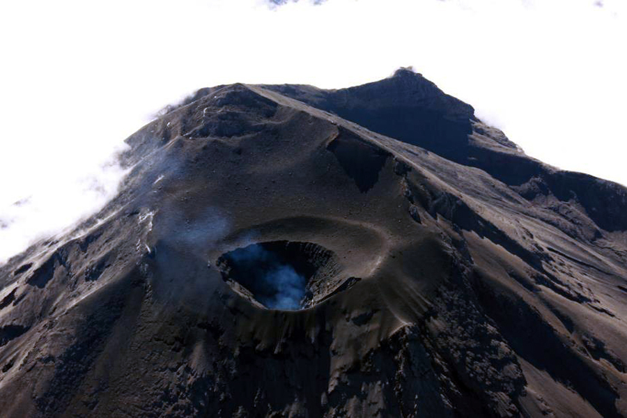
Although quieter, Tungurahua was still active through November and December 2014. Trace amounts of ash in the emissions were observed from El Manzano on 3 November. On 7 and 8 November ash-bearing plumes rose less than 300 m and drifted WSW. For the rest of November, only steam plumes rose to 700 m above the crater. Incandescence was visible at the summit in the early morning hours of 21 November, and again on 4 December. Residents in Choglontus reported a steam-and-ash plume drifting S early on 6 December. A significant lahar on the NW flank washed out the Penipe-Banos road in the Achupashal gorge on 7 December. Low ash content was reported in plumes rising to 500 m above the crater each day from 9-15 December, and magmatic gases and steam emissions were persistent (figure 80). Slight incandescence was seen at night on 11 December. On 14 December, a column consisting of re-suspended ash was seen drifting E. For the remainder of December, weak water vapor plumes rose a few hundred meters above the crater; lahars were reported on 25 December.
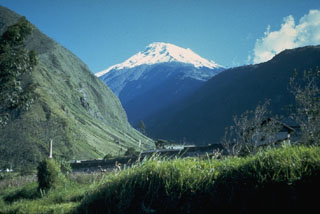
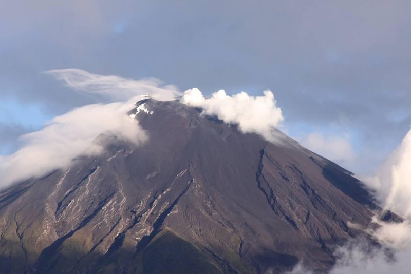
Geological Summary. Tungurahua, a steep-sided andesitic-dacitic stratovolcano that towers more than 3 km above its northern base, is one of Ecuador's most active volcanoes. Three major edifices have been sequentially constructed since the mid-Pleistocene over a basement of metamorphic rocks. Tungurahua II was built within the past 14,000 years following the collapse of the initial edifice. Tungurahua II collapsed about 3,000 years ago and produced a large debris-avalanche deposit to the west. The modern glacier-capped stratovolcano (Tungurahua III) was constructed within the landslide scarp. Historical eruptions have all originated from the summit crater, accompanied by strong explosions and sometimes by pyroclastic flows and lava flows that reached populated areas at the volcano's base. Prior to a long-term eruption beginning in 1999 that caused the temporary evacuation of the city of Baños at the foot of the volcano, the last major eruption had occurred from 1916 to 1918, although minor activity continued until 1925.
Information Contacts: Instituto Geofísico (IG), Escuela Politécnica Nacional, Casilla 17-01-2759, Quito, Ecuador (URL: http://www.igepn.edu.ec/); Washington Volcanic Ash Advisory Center (VAAC), Satellite Analysis Branch (SAB), NOAA/NESDIS OSPO, NOAA Science Center Room 401, 5200 Auth Rd, Camp Springs, MD 20746, USA (URL: http://www.ospo.noaa.gov/Products/atmosphere/vaac/, archive at: http://www.ssd.noaa.gov/VAAC/archive.html); Hawai'i Institute of Geophysics and Planetology (HIGP), MODVOLC Thermal Alerts System, School of Ocean and Earth Science and Technology (SOEST), Univ. of Hawai'i, 2525 Correa Road, Honolulu, HI 96822, USA (URL: http://modis.higp.hawaii.edu/); MIROVA (Middle InfraRed Observation of Volcanic Activity), a collaborative project between the Universities of Turin and Florence (Italy) supported by the Centre for Volcanic Risk of the Italian Civil Protection Department (URL: http://www.mirovaweb.it/); NASA Goddard Space Flight Center (NASA/GSFC), Global Sulfur Dioxide Monitoring Page, Atmospheric Chemistry and Dynamics Laboratory, 8800 Greenbelt Road, Goddard, Maryland, USA (URL: https://so2.gsfc.nasa.gov/); USA Today (URL: http://www.usatoday.com/story/news/world/2013/07/14/ecuador-volcano-spews-ash/2516393/).

