Report on Dukono (Indonesia) — June 2017

Bulletin of the Global Volcanism Network, vol. 42, no. 6 (June 2017)
Managing Editor: Edward Venzke.
Research and preparation by Robert Andrews.
Dukono (Indonesia) Frequent explosive eruptions and ash plumes through March 2017
Please cite this report as:
Global Volcanism Program, 2017. Report on Dukono (Indonesia) (Venzke, E., ed.). Bulletin of the Global Volcanism Network, 42:6. Smithsonian Institution. https://doi.org/10.5479/si.GVP.BGVN201706-268010
Dukono
Indonesia
1.6992°N, 127.8783°E; summit elev. 1273 m
All times are local (unless otherwise noted)
Eruptive activity at Dukono has continued since 1933. As previously reported, ash explosions were frequently observed, and thermal anomalies were intermittent, from September 2011 through July 2014 (BGVN 39:06). Similar activity has continued through March 2017. Monitoring is conducted by the Indonesian Center for Volcanology and Geological Hazard (PVMBG, also known as CVGHM) from an observation post 11 km away. The Alert Level has remained at 2 (on a scale of 1-4), with residents and tourists advised to not approach the crater within a radius of 2 km.
PVMBG reported that in March-April 2015 seismicity remained high and consisted of explosion signals, volcanic earthquakes, and tremor, accompanied by roaring heard at the observation post. A powerful explosion on 23 May 2015 was followed by minor ashfall in areas to the E. During 1-5 July 2015 white-and-gray plumes rose as high as 600 m; minor ashfall was reported in northern areas on 1 July. Ashfall was reported in areas from the Galela District to Tobelo town (NNW) in August 2015 and at the observation post in September. Seismicity fluctuated at high levels, with elevated periods during 15-22 August, 28 August-5 September, and 15-25 October 2015.
As summarized by PVMBG, the period from 1 January to 19 December 2016 exhibited white-and-gray plumes rising as high as 1.2 km above the rim of the Malupang Warirang crater, accompanied by roaring heard at the observation post. The eruption plume height generally fluctuated though, was higher during periods in May and from late November into December; ashfall increased during the periods of higher plume heights, and was noted in villages within 11 km N, NE, and SW. Seismicity remained high.
Nearly daily aviation advisories from the Darwin VAAC (Volcanic Ash Advisory Centre) since July 2014 confirmed the PVMBG reports. As identified in satellite imagery, white and gray ash plumes were seen rising to altitudes of 1.5-4 km from the Malupang Warirang crater, and drifting in various directions for tens to hundreds of kilometers. Data compiled from VAAC reports and summarized by month for April 2016-March 2017 (table 15) reveal plume altitudes between 1.5 and 3.7 km with visible drift distances up to 300 km away.
Table 15. Monthly summary of reported ash plumes from Dukono for April 2016-March 2017. The direction of drift for the ash plume was highly variable. Data from Darwin VAAC and PVMBG.
| Month | Plume Altitude (km) | Plume Drift (km) |
| Apr 2016 | 2.1-3 | 55-250 |
| May 2016 | 2.1-2.7 | 65-185 |
| Jun 2016 | 1.9-2.4 | 55-130 |
| Jul 2016 | 1.8-2.4 | 110-225 |
| Aug 2016 | 1.5-3.3 | 130-280 |
| Sep 2016 | 1.8-3 | 160-250 |
| Oct 2016 | 2.1-2.4 | 215-225 |
| Nov 2016 | 2.1-3.7 | -- |
| Dec 2016 | 1.7-3 | 55-305 |
| Jan 2017 | 1.8-2.7 | 120-300 |
| Feb 2017 | 1.8-2.4 | 120 |
| Mar 2017 | 1.5-2.7 | 150 |
Intermittent thermal anomalies, typically single pixels, were recorded by MODVOLC (table 16) in the months of April and June 2014, January-March 2015, December 2015, and November 2016. MODIS thermal data recorded by the MIROVA system during the year of April 2016-March 2016 (figure 6) showed intermittent low-power anomalies in May and August 2016, and then in every month from October 2016 through March 2017. It should be noted that the MODIS satellite thermal sensors cannot penetrate cloud cover, which is frequent over Dukono much of the year.
Table 16. Thermal anomalies at Dukono based on MODIS data processed by MODVOLC, August 2014-March 2017. Courtesy of Hawai'i Institute of Geophysics and Planetology (HIGP) - MODVOLC Thermal Alerts System.
| Date (UTC) | Time (UTC) | Pixels | Satellite |
| 28 Apr 2014 | 1410 | 1 | Terra |
| 01 Jun 2014 | 1655 | 1 | Aqua |
| 13 Jun 2014 | 1715 | 1 | Aqua |
| 14 Jan 2015 | 1725 | 1 | Aqua |
| 18 Jan 2015 | 1700 | 1 | Aqua |
| 20 Jan 2015 | 1645 | 2 | Aqua |
| 21 Jan 2015 | 1730 | 2 | Aqua |
| 22 Jan 2015 | 1340 | 1 | Terra |
| 23 Jan 2015 | 0200 | 1 | Terra |
| 23 Jan 2015 | 2317 | 4 | Aqua |
| 25 Jan 2015 | 1705 | 1 | Aqua |
| 01 Feb 2015 | 1415 | 1 | Terra |
| 01 Feb 2015 | 1710 | 1 | Aqua |
| 30 Mar 2015 | 1705 | 1 | Aqua |
| 31 Dec 2015 | 1345 | 1 | Terra |
| 04 Nov 2016 | 1700 | 1 | Aqua |
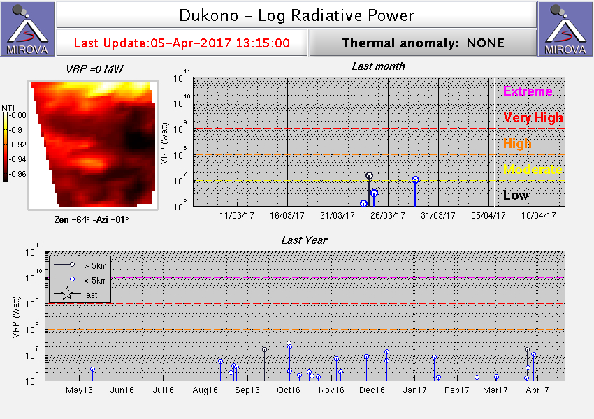 |
Figure 6. Thermal anomalies (Log Radiative Power) detected by MODIS and recorded by the MIROVA system for year ending 5 April 2017. Courtesy of MIROVA. |
Vistors to the crater in March 2016 photographed ash rising form an incandescent vent (figure 7). Patrick Marcel reported that "the vents at the bottom of the crater emitted a sustained, extremely noisy jet of gas, steam and ash, and ejected incandescent bombs to up to 500 m height. Some of them landed outside the crater rim." The "You&MeTraveling2" blog posted a trip journal that described a late-August 2016 visit to Dukono, including photos and a video looking down into the crater that showed activity similar to that seen by Marcel in March 2016.
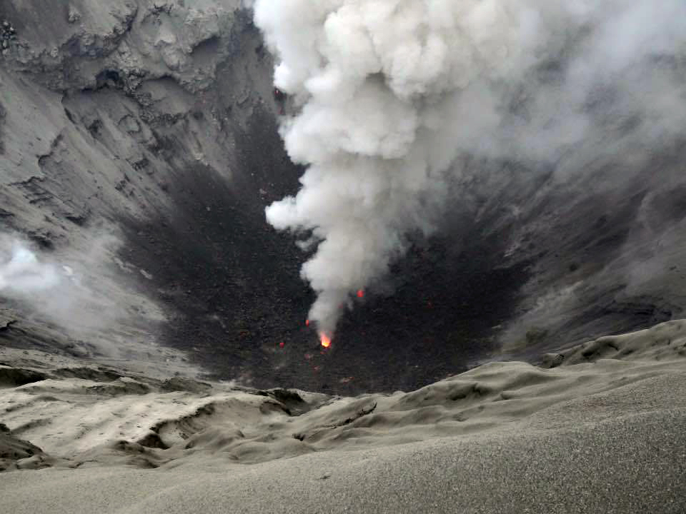 |
Figure 7. View into Dukono's crater on 12 March 2016. Photo by Patrick Marcel (color adjusted from original); courtesy of Volcano Discovery. |
Geological Summary. The Dukono complex in northern Halmahera is on an edifice with a broad, low profile containing multiple peaks and overlapping craters. Almost continuous explosive eruptions, sometimes accompanied by lava flows, have occurred since 1933. During a major eruption in 1550 CE, a lava flow filled in the strait between Halmahera and the Gunung Mamuya cone, 10 km NE. Malupang Wariang, 1 km SW of the summit crater complex, contains a 700 x 570 m crater that has also had reported eruptions.
Information Contacts: Pusat Vulkanologi dan Mitigasi Bencana Geologi (PVMBG, also known as Indonesian Center for Volcanology and Geological Hazard Mitigation, CVGHM), Jalan Diponegoro 57, Bandung 40122, Indonesia (URL: http://www.vsi.esdm.go.id/); Darwin Volcanic Ash Advisory Centre (VAAC), Bureau of Meteorology, Northern Territory Regional Office, PO Box 40050, Casuarina, NT 0811, Australia (URL: http://www.bom.gov.au/info/vaac/); Hawai'i Institute of Geophysics and Planetology (HIGP) - MODVOLC Thermal Alerts System, School of Ocean and Earth Science and Technology (SOEST), Univ. of Hawai'i, 2525 Correa Road, Honolulu, HI 96822, USA (URL: http://modis.higp.hawaii.edu/); MIROVA (Middle InfraRed Observation of Volcanic Activity), a collaborative project between the Universities of Turin and Florence (Italy) supported by the Centre for Volcanic Risk of the Italian Civil Protection Department (URL: http://www.mirovaweb.it/); Volcano Discovery (URL: http://www.volcanodiscovery.com/); You&MeTraveling2 (URL: http://youandmetraveling2.com/).