Report on Chirinkotan (Russia) — June 2017
Bulletin of the Global Volcanism Network, vol. 42, no. 6 (June 2017)
Managing Editor: Edward Venzke.
Edited by A. Elizabeth Crafford.
Chirinkotan (Russia) Intermittent ash plumes and thermal anomalies June 2013-April 2017, site visit by Russian scientists, August 2015
Please cite this report as:
Global Volcanism Program, 2017. Report on Chirinkotan (Russia) (Crafford, A.E., and Venzke, E., eds.). Bulletin of the Global Volcanism Network, 42:6. Smithsonian Institution. https://doi.org/10.5479/si.GVP.BGVN201706-290260
Chirinkotan
Russia
48.98°N, 153.48°E; summit elev. 724 m
All times are local (unless otherwise noted)
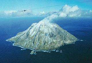
The remote island of Chirinkotan is in the Northern Kuril Islands at the southern end of the Sea of Okhotsk, about 320 km SW of the tip of Kamchatka, Russia. It is an outlier about 40 km NW of the main Kuril Islands Arc. There have been very few historical observations of activity at Chirinkotan, although there is at least one confirmed 19th century observation of lava flows. A short-lived event that resulted in a small, low-level ash plume-and-gas plume was seen in satellite imagery on 20 July 2004 (Neal et al., 2005). Volcanic activity resumed in mid-2013, with intermittent ash plumes, thermal anomalies, and block lava flows reported through April 2017. The volcano is monitored by the Sakhalin Volcanic Eruption Response Team (SVERT) of the Institute of Marine Geology and Geophysics (Far Eastern Branch, Russian Academy of Science), and aviation alerts are issued by the Tokyo Volcanic Ash Advisory Center (VAAC).
A new eruptive phase began with a likely ash emission on 11 June 2013. Intermittent thermal anomalies and gas-and-steam emissions were reported for the next 12 months, sometimes drifting up to 100 km, usually SE. Renewed thermal anomalies and gas emissions were recorded during clear weather beginning on 21 November 2014. Two ash plumes observed in late July 2015 were the likely sources of fresh ashfall and block lava flows sampled during a visit by Russian geoscientists on 9 August 2015. A gas-and-steam plume on 17 November 2015 was the last activity observed, except for low-level thermal anomalies, until a substantial ash plume was captured in satellite data at 8.8 km altitude over a year later on 29 November 2016. Additional ash plumes were observed in satellite data once in late January, and twice each in March and April 2017.
Activity during May 2013-June 2014. After no reports of activity since July 2004, SVERT observed gas-and-steam emissions in satellite imagery beginning in late May 2013. They raised the Alert Level from Green to Yellow (on the four level Green-Yellow-Orange-Red scale) sometime between 27 May and 10 June. The first likely ash emission was reported on 11 June, followed by a thermal anomaly detected on 13 June. Thermal anomalies continued to be detected by SVERT during June and July 2013. The first MODVOLC thermal alert was reported on 22 July; they were reported monthly after that through 11 December 2013, with several days of multiple-pixel alerts. SVERT also noted thermal anomalies and gas-and-steam emissions during August through December, including plumes drifting 30-60 km SE during 17-19 October, 55-100 km SE during 5-6 November, and more than 50 km SE on 25 November.
From the beginning of January 2014 through early June, persistent thermal anomalies were observed in clear imagery nearly every week by SVERT, along with intermittent steam-and-gas emissions. Several times during March, plumes were observed drifting 80-170 km SE. MODVOLC thermal alerts were reported on 8 February, 4 days in March (four pixels on 8 March), and twice on 27 May. SVERT reported that beginning on 24 May, gas emissions containing ash were detected in satellite images. A decrease in thermal anomalies observed by SVERT led them to lower the Alert Level to Green on 5 June 2014.
Activity during November 2014-July 2015. SVERT raised the Alert Level back to Yellow in late November 2014, citing new thermal anomalies beginning on 21 November followed by intermittent steam-and-gas emissions. A plume was observed drifting 40 km SE on 27 November. A new MODVOLC thermal alert appeared on 4 December. SVERT reported thermal anomalies and diffuse gas-and-steam plumes during December 2014 and January-February 2015. Emissions were detected 3 km above Chirinkotan drifting SE on 5 January 2015. MODVOLC reported two thermal alert pixels on 7 January and one on 10 January.
SVERT briefly lowered the Alert Level to Green between 4 and 20 March when no activity was detected. Thermal anomalies were reported again beginning on 19 March; they were noted weekly along with intermittent gas-and-steam emissions through mid-May when the Alert Level was lowered back to Green again on 19 May.
MODVOLC reported a three-pixel thermal alert on 20 July 2015 (local time). The Tokyo VAAC reported an eruption on 21 July (local time) with an ash plume rising to 3.7 km altitude drifting SE. The plume was observed in satellite imagery for about 2 hours before dissipating. SVERT reported a thermal anomaly and steam-and-gas emissions on 22 July, and the Alert Level was raised to Yellow. Another ash plume was reported by the Tokyo VAAC on 26 July rising to an altitude of 4.6 km and drifting NW for several hours before dissipating.
Expedition during August 2015. Scientists from the Institute of Marine Geology and Geophysics (IMGiG) of the Far Eastern Branch of the Russian Academy of Sciences visited Chirinkotan on 9 August 2015. While there, they observed steaming from a recent blocky lava flow near the coast (figure 3), hiked to the summit, and collected data about volcanic and biological activity on the island. A group of researchers climbed to the edge of the summit crater at 600 m elevation, where clouds prevented clear views of the crater (figure 4), however the strong odor of sulfur and noise from fumarolic activity was noted. The scientists sampled the fresh pyroclastic rocks. When the visibility improved, the depth of the crater was observed to be about 150 m; an extrusive dome in the center had a vent on the top emitting gas.
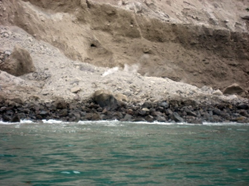 |
Figure 3. Steam rising from recent lava flow at Chirinkotan that reached the coastline, 9 August 2015. Courtesy of IMGiG (Diary of the Kurils 2015 Expedition, 7-9 August 2015, http://imgg.ru/ru/news/111 ). |
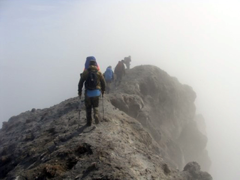 |
Figure 4. Fieldwork at the summit crater rim of Chirinkotan, 9 August 2015. Courtesy of IMGiG. (Diary of the Kurils 2015 Expedition, 7-9 August 2015, http://imgg.ru/ru/news/111 ). |
The upper flank of the volcano was strewn with ash and bombs (from 2-3 cm to several meters in diameter). Scientists observed recently buried and charred living vegetation, and nesting birds freshly killed by volcanic ash and bombs, indicating a very recent event (figure 5). The botanists in the research group noted that all of the vegetation on the upper and middle flanks had been killed 2-3 years ago in a major event, likely during the start of the 2013 eruptive cycle. Ash deposits ranged in thickness from a few centimeters near the coast to 8-15 cm near the summit. During a survey of a pyroclastic flow on the SW coast, scientists noted that it was still hot on the surface (40-60°?) and consisted of block lava, bombs, and volcanic ash (figure 6).
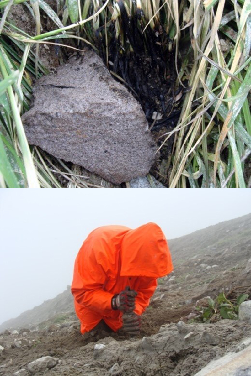 |
Figure 5. Evidence of recent explosive activity at Chirinkotan. Top: recently burned vegetation from a volcanic bomb on the flank. Bottom: living vegetation buried in recent volcanic ash, 9 August 2015. Courtesy of IMGiG (Diary of the Kurils 2015 Expedition, 7-9 August 2015, http://imgg.ru/ru/news/111 ). |
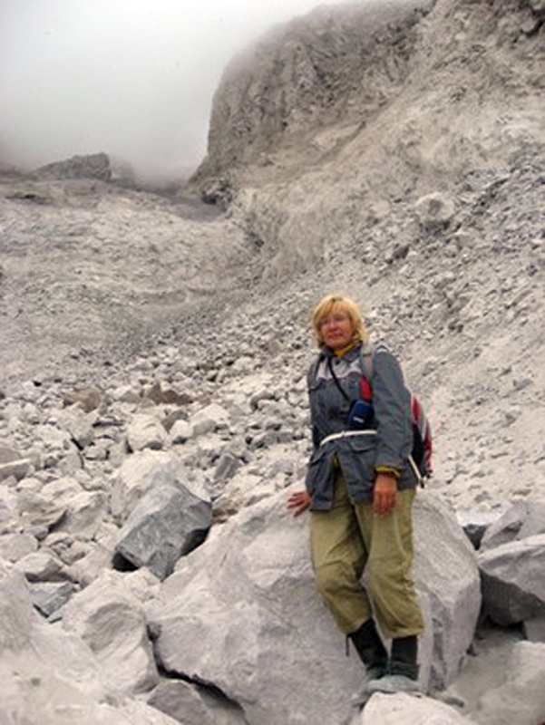 |
Figure 6. Still-hot debris from a block lava flow on Chirinkotan, 9 August 2015. Courtesy of IMGiG (Diary of the Kurils 2015 Expedition, 7-9 August 2015, http://imgg.ru/ru/news/111 ). |
Activity during November 2015-April 2017. As a result of the direct observations of the recent eruption on the island, SVERT raised the Alert Level to Orange on 11 August 2015. There were no further reports available from SVERT until 17 November when gas-and-steam emissions were detected, and the Aviation Color Code was reported as Yellow. SVERT reported on 7 December 2015 that the ACC had been lowered to Green. Although SVERT did not report renewed activity from Chirinkotan until it issued a VONA on 29 November 2016 and raised the Alert Level to Yellow, the MIROVA thermal anomaly detection system indicated intermittent low-level anomalies between late May and early October 2016 (figure 7), indicating a heat source on the island.
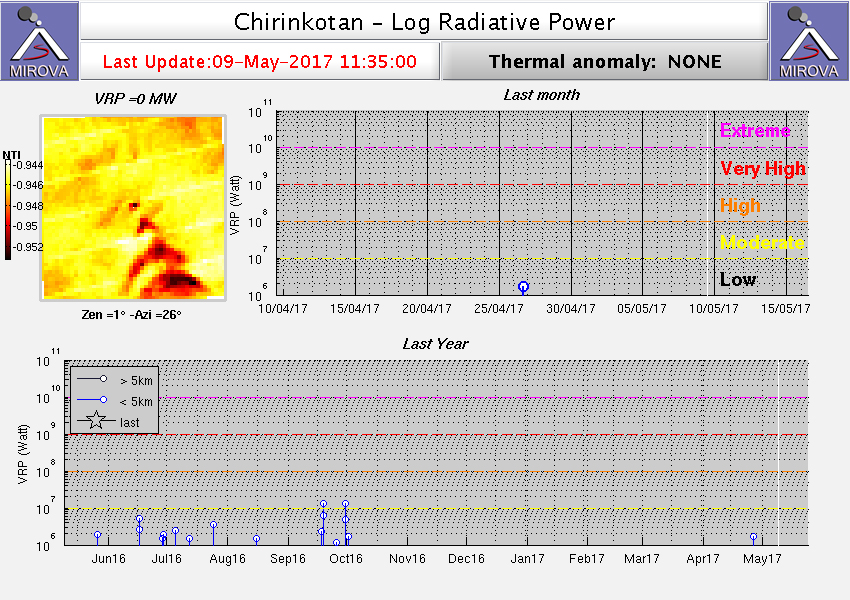 |
Figure 7. MIROVA data of Log Radiative Power at Chirinkotan for the year ending on 31 January 2017 showing a weak but persistent thermal anomaly between late May and early October 2016. Courtesy of MIROVA. |
The Tokyo VAAC issued a report of a volcanic ash plume from an eruption on 29 November (local time) 2016. The plume rose to 8.8 km altitude and drifted N. It was observed in satellite imagery for about 9 hours before dissipating. SVERT briefly raised the ACC to Yellow between 29 November and 2 December. They noted that the ash plume was observed drifting 39 km N. A new report of ash emissions came from the Tokyo VAAC on 26 January 2017, with an ash plume at 3.7 km drifting SE observed in the Himawari-8 satellite imagery. SVERT raised the alert level to Yellow on 27 January (UTM) 2017 and also noted ash emissions on 29 January drifting SE to a maximum distance of 105 km. They lowered the Alert Level to Green on 1 February 2017.
A new ash plume was observed by the Tokyo VAAC on 1 March (local time) 2017 at an altitude of 5.5 km. When SVERT raised the Aviation Color Code to Yellow on 2 March, they noted that the plume had drifted 165 km E. They lowered the ACC back to Green on 6 March. The Tokyo VAAC reported a new ash plume at 6.1 km extending SE early on 21 March 2017. SVERT reported the emission at 15 km E of the volcano when they raised the ACC to Yellow a short while later. They noted on 24 March, when they lowered the ACC to Green, that the maximum extent of the ash cloud had been about 50 km SE.
On 31 March 2017, the Tokyo VAAC issued an advisory for an ash plume at 6.7 km altitude drifting E, and SVERT raised the Alert Level to Yellow the next day. They reported the ash plume drifting 165 km NE before dissipating. Another plume on 7 April was observed by the Tokyo VAAC at 3.7 km altitude drifting SE. SVERT reported the plume at 5 km altitude drifting NE. SVERT lowered the ACC to Green on 24 April 2017.
Reference: Neal C A, McGimsey R G, Dixon J, Melnikov D, 2005. 2004 volcanic activity in Alaska and Kamchatka: summary of events and response of the Alaska Volcano Observatory. U S Geol Surv, Open-File Rpt, 2005-1308: 1-67.
Geological Summary. The small, mostly unvegetated 3-km-wide island of Chirinkotan occupies the far end of an E-W volcanic chain that extends nearly 50 km W of the central part of the main Kuril Islands arc. It is the emergent summit of a volcano that rises 3000 m from the floor of the Kuril Basin. A small 1-km-wide caldera about 300-400 m deep is open to the SW. Lava flows from a cone within the breached crater reached the shore of the island. Historical eruptions have been recorded since the 18th century. Lava flows were observed by the English fur trader Captain Snow in the 1880s.
Information Contacts: Sakhalin Volcanic Eruption Response Team (SVERT), Institute of Marine Geology and Geophysics, Far Eastern Branch, Russian Academy of Science, Nauki st., 1B, Yuzhno-Sakhalinsk, Russia, 693022 (URL: http://www.imgg.ru/en/, http://www.imgg.ru/ru/svert/reports); Tokyo Volcanic Ash Advisory Center (VAAC), 1-3-4 Otemachi, Chiyoda-ku, Tokyo, Japan (URL: http://ds.data.jma.go.jp/svd/vaac/data/); Institute of Marine Geology and Geophysics, Far Eastern Branch of the Russian Academy of Sciences, (FEB RAS IMGiG), 693 022 Russia, Yuzhno-Sakhalinsk, ul. Science 1B (URL: http://imgg.ru/ru); Hawai'i Institute of Geophysics and Planetology (HIGP), MODVOLC Thermal Alerts System, School of Ocean and Earth Science and Technology (SOEST), Univ. of Hawai'i, 2525 Correa Road, Honolulu, HI 96822, USA (URL: http://modis.higp.hawaii.edu/); MIROVA (Middle InfraRed Observation of Volcanic Activity), a collaborative project between the Universities of Turin and Florence (Italy) supported by the Centre for Volcanic Risk of the Italian Civil Protection Department (URL: http://www.mirovaweb.it/).