Report on Turrialba (Costa Rica) — June 2017

Bulletin of the Global Volcanism Network, vol. 42, no. 6 (June 2017)
Managing Editor: Edward Venzke.
Edited by A. Elizabeth Crafford.
Turrialba (Costa Rica) Persistent explosions and ash emissions during 2015 and 2016
Please cite this report as:
Global Volcanism Program, 2017. Report on Turrialba (Costa Rica) (Crafford, A.E., and Venzke, E., eds.). Bulletin of the Global Volcanism Network, 42:6. Smithsonian Institution. https://doi.org/10.5479/si.GVP.BGVN201706-345070
Turrialba
Costa Rica
10.025°N, 83.767°W; summit elev. 3340 m
All times are local (unless otherwise noted)
Strong fumarolic activity characterized activity at Costa Rica's Turrialba for several decades before a phreatic eruption in January 2010 resulted in ashfall tens of kilometers from the volcano. Since the January-March 2010 eruption, there have been one or two brief eruptive episodes with ash emissions each year, generally lasting days to weeks. An episode from 29 October through 8 December 2014 began with an ash explosion, followed by continuous emissions on 30 and 31 October. Several additional explosions with ash emissions occurred during November, followed by a strong Strombolian explosion on 8 December that included ashfall up to 1 cm thick in places, and ballistics deposited 300 m from the vent (BGVN 40:04). This report covers the increasing ash-emission activity during 2015 and 2016. Information comes primarily from the Observatorio Vulcanologico y Sysmologico de Costa Rica-Universidad Nacional (OVSICORI-UNA). Aviation alerts are issued by the Washington Volcanic Ash Advisory Center (VAAC).
Turrialba began a new eruptive episode with an ash plume on 8 March 2015. Frequent, intermittent ash-bearing events continued through mid-May, and tapered off during June, with a final event reported on 22 June 2015. The larger plumes rose 2-2.5 km above the vent rim and drifted in many different directions, leading to ashfall throughout the region as far as 40 km from the volcano. A 'bubble of magmatic gas' dispersed accumulated ash from the vent on 15 August 2015. An eruption on 16 October 2015 was the largest in a year, and the start of a new series of emissions that persisted through the end of October, dispersing ash for tens of kilometers in most directions. A brief period of ash emissions between 2 and 8 February 2016 deposited ash within a few kilometers of the summit crater. Ash emissions and frequent small explosions between 28 April and 7 May preceded a longer series of emissions that began with a significant explosion on 16 May, included significant ashfall in regions within 30 km, and lasted until late July 2016. Strombolian activity and pyroclastic flows were also reported during late May; ashfall was reported up to 100 km SW. A new series of explosions and ash emissions began on 13 September that continued nearly uninterrupted through the end of the year, although ashfall reports were greatest in October 2016.
Activity during 2015. Little activity was reported during January and February 2015. Seismicity slowly increased from short-duration, low-amplitude, higher-frequency events in January to more lower-frequency events in February. Very-long-period earthquakes (VLP's) began to register in February and became more pronounced during March, when some were associated with explosions and ash emissions. The first, short, effusive emissions with low ash content occurred on 8 March. The largest events with prolonged ash emissions occurred on 12 (figure 43) and 15 March.
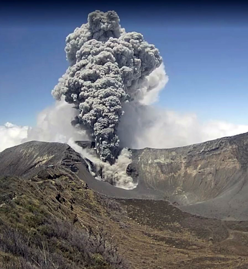 |
Figure 43. Eruption at Turrialba on 12 March 2015. Webcam image courtesy of OVSICORI (Boletín de Vulcanología Estado de los Volcanes de Costa Rica, January, February, March 2015). |
Based on webcam views, weather models, and OVSICORI-UNA updates, the Washington VAAC reported that on 8 March diffuse ash emissions rose from the Cráter Oeste (West Crater) and seismicity increased. OVSICORI-UNA reported more ash emissions on 11 and 12 March. Almost continuous ash emissions were observed in the afternoon of 12 March punctuated by two noticeable explosions. Ash plumes rose as high as 2 km above the crater and drifted NW. Ashfall also occurred in the Valle Central and in the capital of San José (30 km WSW), and caused the closure of the Juan Santamaria International Airport (48 km W), which reopened during the evening on 13 March. The local Tobias Bolanos airport (40 km WSW) closed intermittently. On 13 March three short-duration explosions were reported. According to the Washington VAAC, ash plumes that day drifted 45 km NE at an altitude of 9.1 km, and drifted over 35 km W at an altitude of 6.1 km.
On 18 March, OVSICORI-UNA reported that gas, vapor, and ash plumes rose from Cráter Oeste and seismicity remained high. Observers in Finca La Central (2 km SW) noted gas-and-steam emissions. On 19 March two gas-and-water-vapor emissions were observed; one from Cráter Central contained a small amount of ash. At 1400 the webcam recorded strong emissions of gas, vapor, and tephra from Cráter Oeste. On 23 March a gas, vapor, and ash plume rose from Cráter Oeste, causing ashfall in areas E and SE of the crater including in the Cráter Central and El Mirador. In addition, a dense and vigorous gas-and-vapor plume caused Parque Nacional Volcán Turrialba authorities to recommend masks for protection against gas inhalation.
There were 11 gas-and-ash eruptions and 10 additional smaller ash emissions during April 2015. OVSICORI-UNA reported that a small ash eruption occurred on 3 April, causing ashfall in nearby areas including Silvia and La Central. On 5 April, an eruption generated a plume that rose 500 m and caused ashfall in Curridabat (31 km WSW), Granadilla (29 km WSW), San Pedro, Desamparados (35 km WSW), Aserrí (40 km SW), San Sebastián (37 km WSW), and Escazú (42 km WSW). The eruption of 7 April was the largest of the month (figure 44), and although it occurred at night, the visible ash plume rose to about 2.5 km above the summit. Ash and sulfur odors were reported in many areas of the city of San José (30-40 km WSW). The largest quantities of ash fell in the La Picada and La Silvia communities a few kilometers NNE of the volcano, and affected several hundred cows and other animals at dairy farms. Small ash emissions occurred on 8, 16, and 18 April, and every day during 20-24 April. The ash on 20 April dispersed N and affected Guápiles (20 km N). On 23 and 24 April, ash dispersed NW and affected the inhabitants of the Valle Central, and was reported at Tobias Bolanos and San Juan Santamaria international airports.
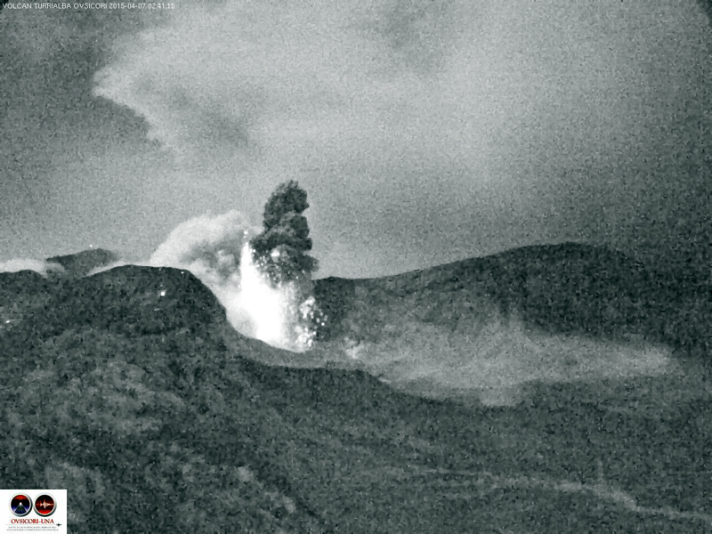 |
Figure 44. Nightime eruption of ash and hot volcanic blocks from Turrialba on 7 April 2015 that began at 0205 and lasted until 0241. Webcam image courtesy of OVSICORI-UNA, (Boletín de Vulcanología, Estado de los Volcanes de Costa Rica, April 2015) |
During May 2015, OVSICORI-UNA recorded 39 eruptions with ash emissions. In general, the plumes did not rise more than 500 m above the crater, and a few were accompanied by small pyroclastic flows. The largest events were on 1 and 4 May when emissions lasted for 4 and 23 minutes, respectively. The 4 May event produced an ash plume that rose 2.5 km and drifted SW. The eruption ejected ballistics 1 km from the crater. Most of the ashfall occurred around the crater. Reports of minor ashfall and sulfur odors came from communities 30-40 km WSW around the city of San José (Moravia, Coronado, Mata de Plátano, La Uruca, Guadalupe, Tibás, Calle Blancos, San Pedro Montes de Oca, Sabanilla Montes de Oca, Pavas, Zapote, Escazú, Paso Ancho, Curridabat, Santa Ana), and a few localities in the eastern region of Heredia (40 km W). Additional ash emissions were reported on 6, 11, 14, and 18 May. Although the multiple emissions on 18 May lasted as long or longer than earlier events (23 and 25 minutes), they were lower energy, and the plumes rose only 400-500 m above the summit crater.
OVSICORI-UNA reported that ash emissions occurred on 1, 4, 7, and 22 June 2015. The eruption on 1 June was the largest, and the small ash eruption on the afternoon of 22 June deposited ash mainly in the vicinity of the volcano to the SW (figure 45). They also reported a significant decrease in the seismic activity, such that by late June, the RSAM values had returned to levels similar to October 2014, prior to the start of the most recent eruptive events. Significant rains after April 2015 led to a shallow lake forming in the Cráter Oeste. Images taken in July of the Cráter Central showed deposits of eruptive material more than 2 m thick compared with May 2014.
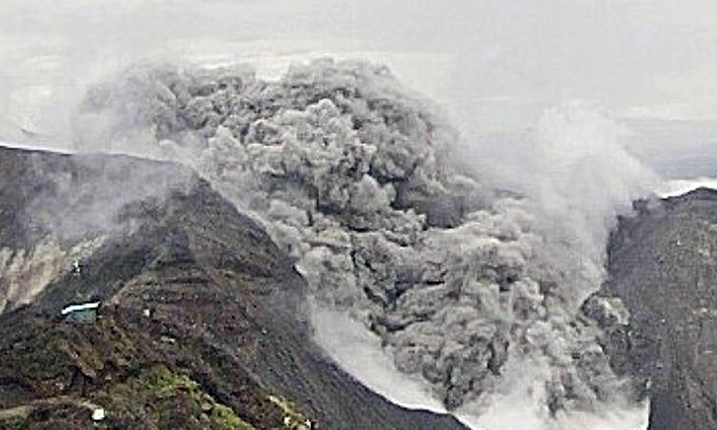 |
Figure 45. Eruption at Turrialba on 22 June 2015. Webcam image courtesy of OVSICORI-UNA (Boletín de Vulcanología, Estado de los Volcanes de Costa Rica, June 2015). |
Seismicity continued to decrease during August 2015. However, an event on 15 August comprised nine hours of tremor associated with the ascent and escape of a bubble of magmatic gas, according to OVSICORI-UNA. The resulting ash ejection was believed to be material that had accumulated at the bottom of the crater. Seismicity remained low during September, with no reported ash emissions.
An increase in seismicity began on 1 October 2015, and until a large eruption on 16 October (figure 46). This was followed on 23 October by a lengthy sequence of ash emissions that continued until 31 October. The 16 October eruption was the largest in terms of energy since the 30 October 2014 eruption. Most of the ash fell on the summit, but a plume headed NW and minor ashfall was reported in parts of the Valle Central such as la Unión, Concepción de Tres Ríos, Montes de Oca (30 km WSW), San Rafael de Coronado (26 km WSW), and Moravia (27 km W). A strong odor of sulfur was reported in Tierra Blanca (18 km SW), Pacayas (12 km SSW), Moravia, and Guadalupe (32 km WSW).
 |
Figure 46. A Google Earth image of Turrialba annotated with images from the 16 and 26 October 2015 eruptions. a) 20-cm- diameter impact from volcanic ejecta. b) Solar panel destroyed by impacts. c) Ash deposit. d) Pyroclastic flow deposit. e) Hot material deposited by the pyroclastic flow. f) Thermal image of an eruption on 26 Of October (Photos: G.Avard). Courtesy of OVSICORI-UNA (Boletín de Vulcanología, Estado de los Volcanes de Costa Rica, October 2015). |
Seismicity increased between 16 and 23 October, when new ash emissions began and were accompanied by pyroclastic flows. Between 23 and 31 October, OVSICORI-UNA reported 57 small emissions and 120 explosions of varying size and characteristics. The Washington VAAC was unable to see most of the emissions in satellite imagery due to weather clouds, however the plumes on 31 October were reported at 4.3 km altitude moving W. Both seismic and eruptive activity declined considerably during November 2015. OVSICORI-UNA reported one small eruption on 27 November and a small explosion on 30 November; they did not mention ash related to either event.
Activity during 2016. OVSICORI-UNA reported a brief emission of gases and volcanic ash to 500 m above the crater on 2 February 2016. Residents of La Silva (2 km NW) reported a sulfur odor and ashfall on 5 February, and additional emissions above Cráter Oeste on 6 February. The Washington VAAC noted gray emissions on 8 February. The next report, on 3 April, described an explosion lasting less than one minute that generated a small gas-and-ash plume. Seismicity increased on 28 April, followed by ash emissions and frequent small explosions on 30 April and 1 May from Cráter Oeste. Gas-and-tephra emissions increased on 1 May with minor amounts of ash deposited in La Central (4 km SW) and La Pastora (6 km SSE). A larger ash plume on 2 May rose 2 km above the summit, and was followed by frequent explosions producing 1-km-high ash plumes the next day. Frequent explosions were again recorded during 3-5 May with ash plumes rising up to 1 km above Cráter Oeste. Small lahars were reported on 7 May, and small, frequent ash emissions accompanied spasmodic tremor on 8 May.
A significant explosion on 16 May 2016, that caused abundant ashfall on farms 2.5 km WNW, was the start of a new episode that lasted for more than two months. Frequent ash emissions continued the next day, although seismic tremor amplitude decreased substantially from the initial explosion. Numerous gas-and-ash emissions were reported during 17-19 May. Ashfall was reported in areas of Valle Central (30-40 km W), including Coronado, Guadalupe, and Heredia (38 km W). On 20 May a Strombolian phase began, producing an ash-and-gas plume that rose 3 km and drifted W. The eruptive column collapsed, generating pyroclastic flows that reached the nearby ranches of La Silva and La Picada, and the Cráter Central. According to a news article, some airlines canceled or delayed flights into the Juan Santamaría International Airport (48 km W).
Gas-and-ash emissions continued during 21-22 May; plumes rose as high as 600 m above the summit. Villagers reported ashfall in areas of San José (40 km WSW), Cartago (25 km SW), Alajuela (49 km W), Heredia (38 km W), Puriscal (65 km WSW), and Jaco (100 km SW). Ash plumes rose as high as 1 km and drifted W and SW on 23 May, causing ashfall in areas downwind including Tapezco (Zarcero-Alfaro Ruíz, 70 km WNW), Guácima de Alajuela (55 km WSW), Barva (39 km W), Finca Lara (17 km W), Finca Laguna (23 km WNW), Grecia, and Naranjo. A strong explosion on 24 May generated new ash plumes that rose 3.5 km and drifted SW. This event ejected large rocks around the crater and led to ashfall in multiple areas including Santa Rosa de Oreamuno, Santa Cecilia de Heredia, and San Francisco de Heredia, tens of kilometers to the W. Large amounts of ash (deposits 2-7 mm thick) fell in Carthage, Heredia (38 km W), San José (40 km W), and Alajuela (49 km W) from more explosions on 25 May that also ejected incandescent material.
A small explosion on 1 June 2016 began a new sequence of ash emissions, with plumes rising 1-2 km, that lasted until 4 June. Ashfall was reported in a number of communities including San Rafael de Moravia (31 km WSW), Sabana (38 km WSW), Buenos Aires (17 km N), and Pococí (45 km N) during 2-3 June. Ash emissions and explosions on 10 June caused ashfall and/or a sulfur odor in multiple areas of Valle Central including San Luis, Santo Domingo, Moravia, San Francisco, and Coronado. OVSICORI-UNA reported increased seismic activity on 16 June; the webcam showed areas of incandescence. Morning satellite imagery showed a diffuse ash plume extending 45 km WNW of the summit that dissipated by mid-afternoon. Tremor increased on 23 June, followed by a lengthy sequence of tremor episodes and ash emissions that lasted through 26 June; ashfall was reported in several neighborhoods in San José and Heredia. Increased tremor on 28 June was likely accompanied by ash emissions, but darkness and clouds obscured views from the webcam.
Strong tremor on 7 July 2016 was followed by an ash plume that rose 1 km above the crater and likely drifted WNW and WSW. Ashfall was recorded in many neighborhoods downwind, in San José, Heredia, and Turrubares. Emissions of large amounts of ash were visible in the webcam the next day, and ashfall was reported in many of the same areas as the day before. The Washington VAAC issued daily reports from 7 to 15 July of diffuse ash emissions observed in the webcam, generally rising less than 500 m above the summit. A new series of explosions during 22-25 July were recorded seismically, but visual observations were difficult due to fog. Hot rock fragments, gas, and ash were noted as high as 500 m above the crater on 24 July. Ash plumes rose to 3 km above the crater and drifted NW, W, and SW the next day. OVSICORI-UNA reported possible volcanic ash again on 29 July and 1 August, but weather clouds prevented views in satellite imagery.
Another new series of explosions and ash emissions began on 13 September 2016. They were reported daily from 15 September to the end of the month. Most plumes rose less than 1 km above the crater, but explosions on 19 September generated ash plumes that rose as high as 4 km and resulted in ashfall in many communities in the Valle Central, including those in San José (35 km WSW), Heredia (38 km W), Alajuela, and Cartago (25 km SW). According to news articles, flights in and out of the Juan Santamaría International Airport were canceled; the airport remained closed at least through the morning of 20 September. The Pavas San José Tobías Bolaños Airport in San José was also temporarily closed. Plumes that rose as high as 2 km were reported on 22, 26, and 27 September.
During a 22-24 September field visit OVSICORI-UNA scientists observed a significant lahar in the Rio Toro Amarillo which flows NW from Turrialba, that mobilized logs and large rocks in a 1.5-m-deep flow (figure 47). They had observed 3 cm of fresh ash in the drainage prior to the start of the rainfall on 22 September.
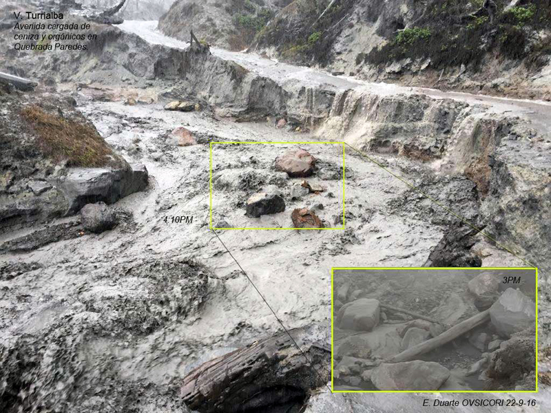 |
Figure 47. The abrupt change in flow conditions was observed by OVSICORI-UNA scientists on 22 September 2016 when heavy rains generated a lahar in the Rio Toro Amarillo at Turrialba. The inset photo shows the same area about an hour before the flooding. Photo by E. Duarte, courtesy of OVSICORI-UNA (Algunos Efectos Proximales y Distales por Acumulación de la Ceniza: Volcán Turrialba, Reporte de campo: 22-24 de setiembre de 2016). |
From 26 September through 24 November 2016 multiple reports were issued by the Washington VAAC virtually every day, usually reporting minor emissions of gas and ash. OVSICORI reported intermittent steam, gas, and ash emissions rising 500-1,000 m during all of October 2016. Ashfall was reported in Guadeloupe on 11 October. On 16 October OVSICORI-UNA noted that the almost constant ash emission in the previous few days affected the operation and communication of various scientific instruments installed at the top of the volcano and surrounding areas; communication with two seismic stations located near the summit was lost. Webcams showed continuing ash emissions rising as high as 1 km during 16-18 October. During 18-25 October, passive ash emissions continued, causing ashfall in Siquirres (30 ENE), Guacimo (23 km NNE), Guapiles (21 km N), Moravia (27 km W), San José (36 km WSW), Tibás (35 km WSW), Guadalupe (32 km WSW), Curridabat (32 km WSW), Tres Ríos (27 km SW), San Pedro (32 km WSW), and various areas of the Valle Central. Ashfall was reported in Nubes de Coronado (25 km W) on 28 October.
There were fewer reports of ashfall during November, although many areas of the Valle Central reported ashfall during 9-13 November. A small quantity of ash fell in Cartago and Paraiso de Cartago (25 km SE) on 20 November. The Washington VAAC again issued near-daily reports of ash and gas plumes between 6 December and the end of 2016. The weak and sporadic emissions generally rose only a few hundred meters, drifting in multiple directions, and there were few reports of ashfall in the surrounding communities.
Geological Summary. Turrialba, the easternmost of Costa Rica's Holocene volcanoes, is a large vegetated basaltic-to-dacitic stratovolcano located across a broad saddle NE of Irazú volcano overlooking the city of Cartago. The massive edifice covers an area of 500 km2. Three well-defined craters occur at the upper SW end of a broad 800 x 2200 m summit depression that is breached to the NE. Most activity originated from the summit vent complex, but two pyroclastic cones are located on the SW flank. Five major explosive eruptions have occurred during the past 3500 years. A series of explosive eruptions during the 19th century were sometimes accompanied by pyroclastic flows. Fumarolic activity continues at the central and SW summit craters.
Information Contacts: Observatorio Vulcanologico Sismologica de Costa Rica-Universidad Nacional (OVSICORI-UNA), Apartado 86-3000, Heredia, Costa Rica (URL: http://www.ovsicori.una.ac.cr/); Washington Volcanic Ash Advisory Center (VAAC), Satellite Analysis Branch (SAB), NOAA/NESDIS OSPO, NOAA Science Center Room 401, 5200 Auth Rd, Camp Springs, MD 20746, USA (URL: http://www.ospo.noaa.gov/Products/atmosphere/vaac/).