Report on Lascar (Chile) — July 2017

Bulletin of the Global Volcanism Network, vol. 42, no. 7 (July 2017)
Managing Editor: Edward Venzke.
Edited by A. Elizabeth Crafford.
Lascar (Chile) Thermal anomaly persists until April 2017
Please cite this report as:
Global Volcanism Program, 2017. Report on Lascar (Chile) (Crafford, A.E., and Venzke, E., eds.). Bulletin of the Global Volcanism Network, 42:7. Smithsonian Institution. https://doi.org/10.5479/si.GVP.BGVN201707-355100
Lascar
Chile
23.37°S, 67.73°W; summit elev. 5592 m
All times are local (unless otherwise noted)
The six overlapping summit craters of northern Chile's Lascar volcano have produced numerous lava flows down the NW flanks. Frequent small-to-moderate explosive eruptions since the mid-19th century, and infrequent larger eruptions, have produced ashfall hundreds of kilometers away. The largest historical eruption took place in 1993, producing pyroclastic flows to 8.5 km NW of the summit and ashfall in Buenos Aires. An explosion on 30 October 2015 produced an ash plume that rose 2.5 km above the 5.6 km high summit and drifted NE; this event also initiated a distinct thermal anomaly signal recorded by MIROVA that continued through June 2016 (BGVN 41:07). Continuous incandescence from the crater was seen for the next two months. The thermal anomaly did not begin to diminish until February 2017; details of activity through June 2017 are reported here with information primarily from Chile's Servicio Nacional de Geología y Minería, (SERNAGEOMIN), and the Italian MIROVA project.
After the 30 October 2015 explosion, a persistent thermal anomaly appeared in the MIROVA data that maintained a near-constant level of activity through June 2016 (figure 49, BGVN 41:07). The MIROVA VRP (Volcanic Radiative Power) values remained steady with multiple weekly anomalies through January 2017 when they began to taper off in both frequency and intensity (figure 46). They were intermittent during February, persistent but at a lower level during March and into the first few days of April. A few anomalies appeared later in April, and one during mid-May 2017; there is no evidence to determine exactly when eruptive activity ended or the cause of the anomalies.
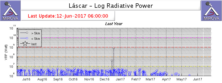 |
Figure 46. Thermal anomaly data from MIROVA (Log Radiative Power) at Lascar for the year ending on 12 June 2017. The thermal anomalies persisted at a steady rate and intensity from November 2015 (see figure 49, BGVN 41:07) through January 2017 when they began to decrease in both frequency and intensity, until they ceased in May 2017. Courtesy of MIROVA. |
Throughout July 2016-June 2017, the local webcam showed persistent degassing of mostly steam plumes from the main crater, with plume heights ranging from 500-1,500 m above the summit (table 6). Although there were three pilot reports of ash emissions from Lascar on 22 and 25 September and 29 December 2016, in each case the Buenos Aires VAAC noted that there was no indication of volcanic ash in satellite images under clear skies; the webcam did show continuous emissions of steam and gas dissipating rapidly near the summit. Seismicity during this period varied from a low of three events during October 2016 to a high of 122 events during June 2017. Although there was an increase in the number of seismic events during April 2017, the total energy released remained low. Continuous incandescence at the crater was observed during October-December 2016.
Table 6. Seismic events, degassing information, and incandescence observed at Lascar from July 2016-June 2017. Information provided by SERNAGEOMIN monthly reports. Maximum height is meters above the 5,592 m elevation summit.
| Month | No of Seismic Events | Degassing | Maximum Height (m) | Date of Maximum Height | Incandescence Observed |
| Jul 2016 | 11 | Steam | 700 | 4 Jul | -- |
| Aug 2016 | 12 | Steam | 850 | 25 Aug | -- |
| Sep 2016 | 24 | Steam | 1,100 | 21 Sep | -- |
| Oct 2016 | 3 | Steam | 1,000 | 28 Oct | Continuous |
| Nov 2016 | 7 | Steam | 1,500 | 4 Nov | Continuous |
| Dec 2016 | 6 | Steam | 1,400 | 20 Dec | Continuous |
| Jan 2017 | 13 | Constant | 800 | 6 Jan | -- |
| Feb 2017 | 36 | Constant | 650 | 19 Feb | -- |
| Mar 2017 | 19 | Constant | 600 | 5 Mar | -- |
| Apr 2017 | 112 | Constant | 600 | 29 Apr | -- |
| May 2017 | 97 | Constant | 560 | 8 May | -- |
| Jun 2017 | 122 | Constant | 500 | 1 Jun | -- |
Geological Summary. Láscar is the most active volcano of the northern Chilean Andes. The andesitic-to-dacitic stratovolcano contains six overlapping summit craters. Prominent lava flows descend its NW flanks. An older, higher stratovolcano 5 km E, Volcán Aguas Calientes, displays a well-developed summit crater and a probable Holocene lava flow near its summit (de Silva and Francis, 1991). Láscar consists of two major edifices; activity began at the eastern volcano and then shifted to the western cone. The largest eruption took place about 26,500 years ago, and following the eruption of the Tumbres scoria flow about 9000 years ago, activity shifted back to the eastern edifice, where three overlapping craters were formed. Frequent small-to-moderate explosive eruptions have been recorded since the mid-19th century, along with periodic larger eruptions that produced ashfall hundreds of kilometers away. The largest historical eruption took place in 1993, producing pyroclastic flows to 8.5 km NW of the summit and ashfall in Buenos Aires.
Information Contacts: Servicio Nacional de Geología y Minería, (SERNAGEOMIN), Observatorio Volcanológico de Los Andes del Sur (OVDAS), Avda Sta María No. 0104, Santiago, Chile ( URL: http://www.sernageomin.cl/); MIROVA (Middle InfraRed Observation of Volcanic Activity), a collaborative project between the Universities of Turin and Florence (Italy) supported by the Centre for Volcanic Risk of the Italian Civil Protection Department (URL: http://www.mirovaweb.it/); Buenos Aires Volcanic Ash Advisory Center (VAAC), Servicio Meteorológico Nacional-Fuerza Aérea Argentina, 25 de mayo 658, Buenos Aires, Argentina (URL: http://www.smn.gov.ar/vaac/buenosaires/inicio.php?lang=es).