Report on Bagana (Papua New Guinea) — August 2017

Bulletin of the Global Volcanism Network, vol. 42, no. 8 (August 2017)
Managing Editor: Edward Venzke.
Research and preparation by Robert Andrews.
Bagana (Papua New Guinea) Frequent ash plumes and thermal anomalies from July 2016 through mid-June 2017
Please cite this report as:
Global Volcanism Program, 2017. Report on Bagana (Papua New Guinea) (Venzke, E., ed.). Bulletin of the Global Volcanism Network, 42:8. Smithsonian Institution. https://doi.org/10.5479/si.GVP.BGVN201708-255020
Bagana
Papua New Guinea
6.137°S, 155.196°E; summit elev. 1855 m
All times are local (unless otherwise noted)
Eruptive activity has been ongoing at Bagana since February 2000, and frequently active for over 150 years. Due to the remote location of this volcano, the most reliable observations of activity come from the identification of ash plumes in satellite imagery by the Darwin Volcanic Ash Advisory Centre (VAAC) and thermal anomalies from satellite infrared sensors.
Since July 2016 (BGVN 41:07), the Darwin VAAC issued aviation warnings of ash plumes almost every week through mid-June 2017. The plumes typically rose to between 1.8 and 3.4 km; the most commonly reported altitude of the plume was about 2.1 km. The plumes drifted in multiple directions depending on the local wind patterns. Drift directions were not always reported, but a few reached 110-120 km, and one was observed as far as 160 km away on 7 September 2016.
MODIS data processed by the MIROVA algorithm (figure 20) reinforce the Darwin VAAC reports of a nearly continuous eruption since July 2016 through mid-June 2017. Frequent MODVOLC thermal alerts, also based on MODIS satellite-based data, corroborate the MIROVA analysis.
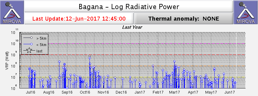 |
Figure 20. Thermal anomalies at Bagana shown on a MIROVA plot (Log Radiative Power) for the year ending 12 June 2017. Courtesy of MIROVA. |
Geological Summary. Bagana volcano, in a remote portion of central Bougainville Island, is frequently active. This massive symmetrical cone was largely constructed by an accumulation of viscous andesitic lava flows. The entire edifice could have been constructed in about 300 years at its present rate of lava production. Eruptive activity is characterized by non-explosive effusion of viscous lava that maintains a small lava dome in the summit crater, although occasional explosive activity produces pyroclastic flows. Lava flows with tongue-shaped lobes up to 50 m thick and prominent levees descend the flanks on all sides.
Information Contacts: Darwin Volcanic Ash Advisory Centre (VAAC), Bureau of Meteorology, Northern Territory Regional Office, PO Box 40050, Casuarina, NT 0811, Australia (URL: http://www.bom.gov.au/info/vaac/); MIROVA (Middle InfraRed Observation of Volcanic Activity), a collaborative project between the Universities of Turin and Florence (Italy) supported by the Centre for Volcanic Risk of the Italian Civil Protection Department (URL: http://www.mirovaweb.it/); Hawai'i Institute of Geophysics and Planetology (HIGP), MODVOLC Thermal Alerts System, School of Ocean and Earth Science and Technology (SOEST), Univ. of Hawai'i, 2525 Correa Road, Honolulu, HI 96822, USA (URL: http://modis.higp.hawaii.edu/).