Report on Tungurahua (Ecuador) — August 2017

Bulletin of the Global Volcanism Network, vol. 42, no. 8 (August 2017)
Managing Editor: Edward Venzke.
Edited by A. Elizabeth Crafford.
Tungurahua (Ecuador) Eruptive episode during April-May 2015, persistent ash emissions and many lahars
Please cite this report as:
Global Volcanism Program, 2017. Report on Tungurahua (Ecuador) (Crafford, A.E., and Venzke, E., eds.). Bulletin of the Global Volcanism Network, 42:8. Smithsonian Institution. https://doi.org/10.5479/si.GVP.BGVN201708-352080
Tungurahua
Ecuador
1.467°S, 78.442°W; summit elev. 5023 m
All times are local (unless otherwise noted)
Abundant ash emissions, Strombolian activity, pyroclastic flows, lahars, and a few lava flows have all been documented at Tungurahua, which lies in the center of Ecuador. Historical observations are recorded back to 1557, and radiocarbon dates are as old as 7750 BCE. Prior to renewed activity in 1999, the last major eruption had occurred during 1916-1918. Since 1999, there have been numerous eruptive episodes, but only a few with breaks in activity longer than three months. Eight distinct episodes of activity occurred from November 2011 through December 2014 that included 10-km-high ash plumes, Strombolian activity, pyroclastic flows, lahars and a lava flow (BGVN 42:05).
Another eruptive episode during April and May 2015 is described below based on information provided by the Observatorio del Volcán Tungurahua (OVT) of the Instituto Geofísico (IG-EPN) of Ecuador, and aviation alerts from the Washington Volcanic Ash Advisory Center (VAAC). Seismic activity increased after a few months of quiet in late February 2015. A new eruptive episode began on 6 April with tremors and ash emissions, which persisted for the next two weeks. Activity tapered off at the end of April. Intermittent ash emissions and ashfall were observed during May. Rainfall led to numerous lahars every month from January through June, many in drainages on the W flank; some were large enough to disrupt travel on local roads.
Activity during January-March 2015. Tungurahua remained quiet during January 2015, although weather conditions prevented visual monitoring for much of the month. Intermittent gas emissions reached 300 m above the crater a few times. Several hundred millimeters of rain during the second week led to numerous lahars on 9 January that descended the Ulba, Vazcún, Juive, Hacienda, Achupashal, Pingullo, Chontapamba, Romero and Rea quebradas (ravines). Most of the lahars consisted of only muddy water, but three carried debris up to 30 cm in diameter in flows several feet wide, moving material at several cubic meters per second (Palmahurco (Juive), Achupashal, and Rea quebradas). During the last week of January, incandescence was noted at the crater on clear nights.
A lahar on 1 February 2015 in the Yuibug sector, reported by an observer in Bilbao, briefly closed the Penipe-Baños road. Clearer weather at the summit in early February revealed weak gas emissions rising to 500 m above the summit crater. IG reported a gradual increase in seismicity beginning on 16 February 2015. They noted an increase in the number of long-period (LP) earthquakes associated with fluid movement near the summit. They also recorded constant inflation since the beginning of January, with an increase in the rate of inflation of the N flank during February. A small explosion was reported on 18 February, but no other surface changes were observed. The Washington VAAC issued a report of a small burst of possible ash and gas seen by the volcano observatory (OVT) mid-day on 24 February at 5.2 km altitude drifting slowly W.
Observatorio del Volcan Tungurahua (OVT) personnel noted steam and gas emissions during 3-5 March 2015 rising 200-500 m above the crater, but no ash was reported. Rainfall led to a lahar on 23 March that carried 30-cm-diameter blocks down the Quebrada de Juive. Seismic activity fluctuated throughout March. After several months of inflation, a sudden change to deflational deformation began on 26 March, as recorded at the RETU station near the summit crater.
Activity during April-June 2015. Moderate amplitude tremors began during the early morning of 6 April 2015; nearby residents reported noises from the volcano starting around 0730 local time, and minor ashfall was reported in Chacauco, Manzano, and Punzupal Alto. Residents of Palitahua reported a gray ash plume drifting W up to 2 km above the crater (figure 81). The seismic events recorded during the following days were all located at depths of 1-6 km, directly under the crater. Ashfall was reported from 6 to 9 April SW and W of the volcano, primarily in the Choglontus sector. On 8 April, ashfall was reported in Manzano, Choglontus, Bilbao, Chacauco, Pillate, and Quero, with accumulation rates of 135-200 grams per square meter per day (g/m2/day). Ashfall increased in Choglontus, reaching 1000 g/m2 during 8 and 9 April. Inflation was again observed at the RETU station beginning on 5 April.
 |
Figure 81. Ash-bearing emissions from Tungurahua drift NW on 6 April 2015. Photo by J. Garcia, courtesy of OVT/IG-EPN (Informe No. 789, Síntesis Semanal del Estado del Volcán Tungurahua, del 31 de marzo al 07 de abril del 2015). |
The webcam revealed continuous emissions of ash beginning on 6 April 2015. A plume was reported at 6.1 km altitude moving W until the following day. On 8 April OVT reported dense ash emissions to 5.9 km altitude, drifting NW. Weather clouds prevented observation in satellite imagery during these days. Local aircraft indicated ash present at 6.7 km altitude on 9 April in spite of extensive weather clouds. A swarm of "drumbeat" LP earthquakes on 10-11 April was followed by moderate ash emissions on 12 April. On 11 April, IG reported an ash cloud moving W and NW from the summit at 5.5 km altitude. An emission on 14 April with moderate amounts of ash rose 500 m above the summit and drifted WSW (figure 82).
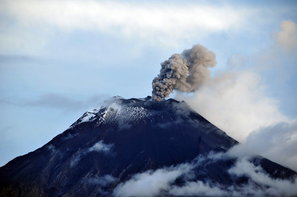 |
Figure 82. An ash emission rises to 500 m above the summit at Tungurahua on 14 April 2015, and drifts WSW. Photo by B. Bernard, Courtesy of OVT/IG-EPN (Informe No. 791, Síntesis Semanal del Estado del Volcán Tungurahua, del 13 al 21 de abril del 2015). |
An explosion on 15 April generated an ash plume that reached 3 km above the summit crater (figure 83). Later in the day ash emissions rose to 2 km above the crater and drifted W. The Washington VAAC reported a continuous ash plume visible in satellite imagery on 15 April moving W from the summit at 6.1 km altitude (1 km above the summit). Although the plume appeared to be almost 100 km long, ashfall reports were limited to areas within 15 km of the summit. Collected ash was mainly composed of dense lithic fragments, euhedral crystals, and oxidized particles, and was not considered juvenile material (from fresh magma). Additional ashfall was reported up through 17 April in Palictahua, El Guanto, El Mirador, El Santuario, Mapayacu, Puela, Chontapamba, and Sabañag.
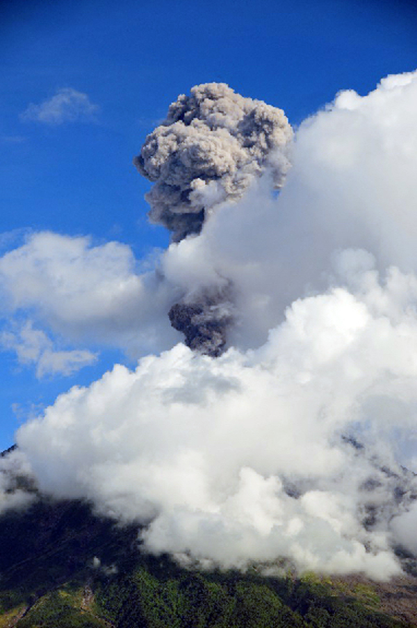 |
Figure 83. An ash plume from an explosion at Tungurahua rises 2 km above the summit crater on 15 April 2015. Photo by B. Bernard, Courtesy of OVT/IG-EPN (Informe No. 791, Síntesis Semanal del Estado del Volcán Tungurahua, del 13 al 21 de abril del 2015). |
Ash emissions continued at a lower level of frequency and energy after 17 April 2015 (figure 84), and seismic activity notably decreased. There were minor emissions coincident with seismic tremors that produced gray to black fine-grained ashfall mainly to the W of the volcano in Bilbao and Chontapamba through 27 April. Deformation changed from inflation to deflation beginning on 21 April, but after five days, switched back to inflation on 26 April. Plumes with moderate ash content were observed rising to 1 or 2 km above the summit on clear days. An emission on 28 April contained modest amounts of ash and drifted NW.
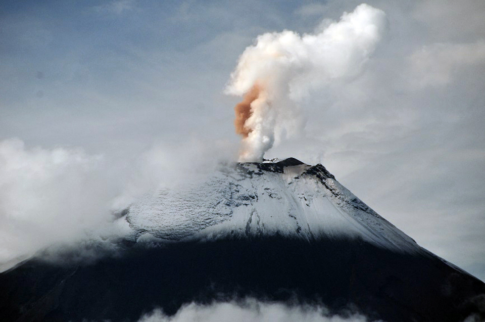 |
Figure 84. A double column of steam and red-brown ash rises 500 m above the crater at Tungurahua and drifts W on 17 April 2015. Photo by B. Bernard, Courtesy of OVT/IG-EPN (Informe No. 791, Síntesis Semanal del Estado del Volcán Tungurahua, del 13 al 21 de abril del 2015). |
Intense rains occurred on 25 and 26 April 2015 that were large enough to generate significant lahars. On 25 April, lahars were reported in the Chontapamba and Romero ravines moving blocks up to 1 m in diameter. Muddy water was observed in the Achupashal ravine. On 26 April, lahars were reported in the Juive, Mapayacu, Romero, and Chontapamba drainages. Lahars caused a high-frequency seismic signal from the Pondoa ravine during the late morning. The flow rates doubled in Vazcún and Puela ravines, which filled with muddy water. A large lahar was also reported in the Quebrada del Pingullo, and debris was reported in the Clementina, Juive Chico, and La Pampa creeks (figure 85).
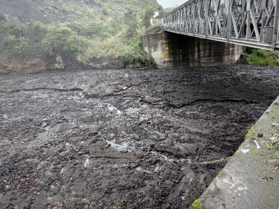 |
Figure 85. Mud and debris filled La Pampa quebrada (ravine) at Tungurahua after heavy rains on 26 April 2015. Photo by S. Aguaiza, courtesy of OVT/IG-EPN (Informe No. 792, Síntesis Semanal del Estado del Volcán Tungurahua, del 21 al 28 de abril del 2015). |
During the first week of May 2015, constant steam emissions rose 1 km above the summit crater. The vapor was characterized by very low amounts of ash. On 4 May, ashfall was reported in the Bilbao sector, but not corroborated from other areas. Steam with low to moderate ash content continued through 12 May, with plumes rising 1 km above the summit, mostly drifting W and SW. As a result, ash falls were reported in Manzano, Choglontús, Yuibug and Bilbao. On 10 and 11 May, intense and prolonged rains led to significant lahars in Q. Romero, Ingapirca, Chontapamba, Achupashal, and Ulba, and smaller lahars in several other ravines. Small mudflows and lahars also occurred in the ravines on the W flank on 12, 14, and 15 May. Cloudy weather mostly prevented views of the summit, but continuous steam emissions were observed when it cleared. Fine-grained gray ashfall was reported in Choglontus on 15 and 20 May.
Minor emissions of steam with no ash to 500 m above the crater, drifting mostly W, persisted throughout June. Intermittent rains resulted in minor lahars and mudflows that caused little damage. Lahars descended ravines on the W flank on 16 and 17 June. The summit was cloudy and rainy for much of the month, and seismic activity remained low.
Geological Summary. Tungurahua, a steep-sided andesitic-dacitic stratovolcano that towers more than 3 km above its northern base, is one of Ecuador's most active volcanoes. Three major edifices have been sequentially constructed since the mid-Pleistocene over a basement of metamorphic rocks. Tungurahua II was built within the past 14,000 years following the collapse of the initial edifice. Tungurahua II collapsed about 3,000 years ago and produced a large debris-avalanche deposit to the west. The modern glacier-capped stratovolcano (Tungurahua III) was constructed within the landslide scarp. Historical eruptions have all originated from the summit crater, accompanied by strong explosions and sometimes by pyroclastic flows and lava flows that reached populated areas at the volcano's base. Prior to a long-term eruption beginning in 1999 that caused the temporary evacuation of the city of Baños at the foot of the volcano, the last major eruption had occurred from 1916 to 1918, although minor activity continued until 1925.
Information Contacts: Instituto Geofísico (IG), Escuela Politécnica Nacional, Casilla 17-01-2759, Quito, Ecuador (URL: http://www.igepn.edu.ec/); Washington Volcanic Ash Advisory Center (VAAC), Satellite Analysis Branch (SAB), NOAA/NESDIS OSPO, NOAA Science Center Room 401, 5200 Auth Rd, Camp Springs, MD 20746, USA (URL: http://www.ospo.noaa.gov/Products/atmosphere/vaac/, archive at: http://www.ssd.noaa.gov/VAAC/archive.html).