Report on Barren Island (India) — September 2017

Bulletin of the Global Volcanism Network, vol. 42, no. 9 (September 2017)
Managing Editor: Edward Venzke.
Research and preparation by Jackie Gluck.
Barren Island (India) Decreased and intermittent thermal anomalies after mid-March 2017
Please cite this report as:
Global Volcanism Program, 2017. Report on Barren Island (India) (Venzke, E., ed.). Bulletin of the Global Volcanism Network, 42:9. Smithsonian Institution. https://doi.org/10.5479/si.GVP.BGVN201709-260010
Barren Island
India
12.278°N, 93.858°E; summit elev. 354 m
All times are local (unless otherwise noted)
Following sporadic activity during the second half of 2016, a new period of strong thermal anomalies suggestive of lava flows began in mid-January 2017 (BVGN: 42:03). Scientists on a nearby research vessel observed ash emissions and lava fountains that fed lava flows during 23-26 January. Subsequent possible activity, as shown by MODIS thermal anomalies detected by MIROVA (figure 26), continued at similar levels until mid-March, after the anomalies became more intermittent and decreased in power through at least 2 September. Thermal alerts in MODVOLC were recorded during 15 January-8 March 2017.
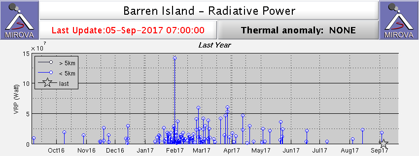 |
Figure 26. Thermal anomaly MIROVA log radiative power data from Barren Island during early September 2016-1 September 2017. Regular, low-moderate activity is evident beginning in late January through April 2017, but it thereafter wanes. Courtesy of MIROVA. |
Geological Survey of India cruise in May 2015. Some observations and photos of activity on 14 and 31 May 2015 have been provided by Sachin Tripathi, a geologist at the Geological Survey of India, who was close to the volcano during the SR-013 cruise of the RV Samudra Ratnakar. On 14 May the plumes were described as light gray "mushroom shaped" clouds. Tripathi further noted that the activity occurred in discrete pulses; he observed two such events during an 8-minute period that sent ash plumes 300-400 m high (figure 27). Eruptive pulses on 31 May lasted about 20-25 seconds, with an interval of 4-5 minutes. The plumes on that day were light gray to gray, and rose to around 50-100 m. The NE portion of the island was covered with ash (figure 28).
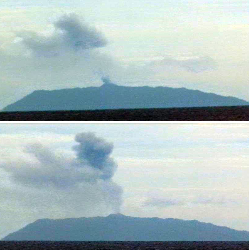 |
Figure 27. Two images from a video that illustrate the pulsating eruption at Barren Island on 14 May 2015. The top image shows the remains of an older plume above the island and a new plume just rising from the summit. The bottom image shows the ash plume rising to about 300-400 m above the island. Courtesy of Sachin Tripathi, Geological Survey of India. |
 |
Figure 28. Photograph of an ash plume rising from the active vent at Barren Island on 31 May 2015. Ashfall can be seen covering the NE portion of the island. Courtesy of Sachin Tripathi, Geological Survey of India. |
Geological Summary. Barren Island, a possession of India in the Andaman Sea about 135 km NE of Port Blair in the Andaman Islands, is the only historically active volcano along the N-S volcanic arc extending between Sumatra and Burma (Myanmar). It is the emergent summit of a volcano that rises from a depth of about 2250 m. The small, uninhabited 3-km-wide island contains a roughly 2-km-wide caldera with walls 250-350 m high. The caldera, which is open to the sea on the west, was created during a major explosive eruption in the late Pleistocene that produced pyroclastic-flow and -surge deposits. Historical eruptions have changed the morphology of the pyroclastic cone in the center of the caldera, and lava flows that fill much of the caldera floor have reached the sea along the western coast.
Information Contacts: Sachin Tripathi, Geological Survey of India; MIROVA (Middle InfraRed Observation of Volcanic Activity), a collaborative project between the Universities of Turin and Florence (Italy) supported by the Centre for Volcanic Risk of the Italian Civil Protection Department (URL: http://www.mirovaweb.it/); Hawai'i Institute of Geophysics and Planetology (HIGP) - MODVOLC Thermal Alerts System, School of Ocean and Earth Science and Technology (SOEST), Univ. of Hawai'i, 2525 Correa Road, Honolulu, HI 96822, USA (URL: http://modis.higp.hawaii.edu/).