Report on Sangeang Api (Indonesia) — September 2017

Bulletin of the Global Volcanism Network, vol. 42, no. 9 (September 2017)
Managing Editor: Edward Venzke.
Research and preparation by Paul Berger.
Sangeang Api (Indonesia) Weak Strombolian activity and occasional weak ash plumes, 15 July-12 August 2017
Please cite this report as:
Global Volcanism Program, 2017. Report on Sangeang Api (Indonesia) (Venzke, E., ed.). Bulletin of the Global Volcanism Network, 42:9. Smithsonian Institution. https://doi.org/10.5479/si.GVP.BGVN201709-264050
Sangeang Api
Indonesia
8.2°S, 119.07°E; summit elev. 1912 m
All times are local (unless otherwise noted)
Strong explosions at Sangeang Api on 30-31 May 2014 generated ash plumes that rose as high as 15 km altitude, followed by less intense activity that produced ash plumes during the first half of June 2014 and 1 July-1 November 2015 (BGVN 41:10). No further activity was reported by the Pusat Vulkanologi dan Mitigasi Bencana Geologi (PVMBG) and Darwin Volcanic Ash Advisory Centre (VAAC) until June 2017.
The MIROVA (Middle InfraRed Observation of Volcanic Activity) system detected thermal anomalies in MODIS satellite data near the summit during the second week of January 2017, when four were recorded (figure 16). The number increased significantly beginning with the latter half of February. Another increase in the number and power of the anomalies took place at the beginning of June 2017 and continued into mid-August.
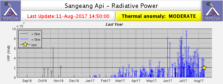 |
Figure 16. Thermal anomalies identified by the MIROVA system (radiative power) at Sangeang Api for the year ending 11 August 2017. Note that the anomaly lines in late 2016 are not on the island. Courtesy of MIROVA. |
Thermal anomalies identified using the MODVOLC algorithm were first recorded on 25 February 2017. Over the same time period as the MIROVA data, through 11 August, there were 105 thermal alerts. Cumulatively, the locations of the alert pixels define an area extending from the summit crater to about 2.5 km down the E flank (figure 17).
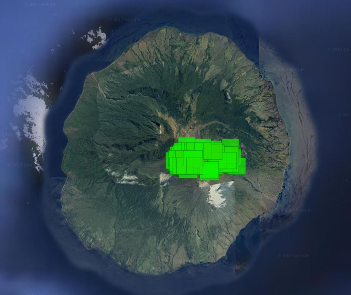 |
Figure 17. Thermal anomalies (alert pixels) identified by the MODVOLC system at Sangeang Api for 25 February-11 August 2017. The eastern-most pixels are at the summit area. Courtesy of HIGP - MODVOLC Thermal Alerts System. |
According to PVMBG, a small Strombolian eruption at 1154 on 15 July 2017 generated an ash plume that rose 100-200 m above the crater rim and drifted SW. Seismicity had increased starting in April. Based on analyses of satellite imagery, PVMBG observations, and wind data, the Darwin VAAC reported that on 16 July an ash plume rose to an altitude of 2.1 km, or 200 m above the crater rim, and drifted NW. The Darwin VAAC also reported ash plumes to altitudes of 2.4-4.3 km on 19-20 July, 29-30 July, 7-8 August, and 12 August 2017; in most cases they drifted NW.
Geological Summary. Sangeang Api volcano, one of the most active in the Lesser Sunda Islands, forms a small 13-km-wide island off the NE coast of Sumbawa Island. Two large trachybasaltic-to-tranchyandesitic volcanic cones, Doro Api and Doro Mantoi, were constructed in the center and on the eastern rim, respectively, of an older, largely obscured caldera. Flank vents occur on the south side of Doro Mantoi and near the northern coast. Intermittent eruptions have been recorded since 1512, most of them during in the 20th century.
Information Contacts: Pusat Vulkanologi dan Mitigasi Bencana Geologi (PVMBG, also known as Indonesian Center for Volcanology and Geological Hazard Mitigation, CVGHM), Jalan Diponegoro 57, Bandung 40122, Indonesia (URL: http://www.vsi.esdm.go.id/); Darwin Volcanic Ash Advisory Centre (VAAC), Bureau of Meteorology, Northern Territory Regional Office, PO Box 40050, Casuarina, NT 0811, Australia (URL: http://www.bom.gov.au/info/vaac/); Hawai'i Institute of Geophysics and Planetology (HIGP) - MODVOLC Thermal Alerts System, School of Ocean and Earth Science and Technology (SOEST), Univ. of Hawai'i, 2525 Correa Road, Honolulu, HI 96822, USA (URL: http://modis.higp.hawaii.edu/); MIROVA (Middle InfraRed Observation of Volcanic Activity), a collaborative project between the Universities of Turin and Florence (Italy) supported by the Centre for Volcanic Risk of the Italian Civil Protection Department (URL: http://www.mirovaweb.it/).