Report on Fogo (Cabo Verde) — September 2017
Bulletin of the Global Volcanism Network, vol. 42, no. 9 (September 2017)
Managing Editor: Edward Venzke.
Edited by A. Elizabeth Crafford.
Fogo (Cabo Verde) November 2014-February 2015 eruption destroys two villages, lava displaces over 1000 people
Please cite this report as:
Global Volcanism Program, 2017. Report on Fogo (Cabo Verde) (Crafford, A.E., and Venzke, E., eds.). Bulletin of the Global Volcanism Network, 42:9. Smithsonian Institution. https://doi.org/10.5479/si.GVP.BGVN201709-384010
Fogo
Cabo Verde
14.95°N, 24.35°W; summit elev. 2829 m
All times are local (unless otherwise noted)
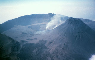
The 25-km-wide island of Fogo in the Cape Verde Islands, 750 km W of Dakar, Senegal, is a single massive stratovolcano with a 9-km-wide summit caldera (Cha Caldera) that is breached to the east. A steep-sided central cone, Pico, rises more than a kilometer above the caldera floor, and is capped by a 500-m-wide, 150-m-deep summit crater; it was apparently almost continuously active from the time of Portuguese settlement in 1500 CE until around 1760. Several lava flows that erupted during the eighteenth and nineteenth centuries reached the eastern coast below the breached caldera rim (BGVN 20:03, figure 1). Lava flows in 1951 and 1995 were contained within the W half of the Cha Caldera, as were the flows from the November 2014-February 2015 eruption (figure 16) described below. Information for this report comes from the Toulouse Volcanic Ash Advisory Center (VAAC), the Observatório Vulcanológico de Cabo Verde (OVCV), and satellite and news data from several sources.
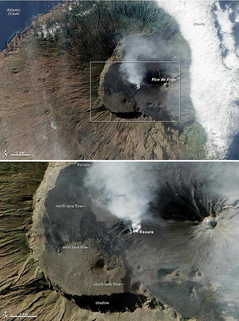 |
Figure 16. The Advanced Land Imager (ALI) on the Earth-Observing 1 (EO-1) satellite captured this image on 24 December 2014 of the eruption at Fogo that began on 23 November 2014. The top image offers a broad view of the island's most distinctive feature: Cha Caldera. The nine-kilometer wide caldera has a western wall that towers a kilometer above the crater floor. The eastern half of the crater wall is gone, erased by an ancient collapse. The lower image shows a more detailed view of the caldera. The volcanic plume streams from a fissure at the SW base of Pico de Fogo, the island's highest point. Both of the villages destroyed by the eruption, Portela and Bangaeira, were located within the caldera. In late November, lava poured into Portela; by 8 December it had entered Bangaeira. The volcanic plume obscures the remains of the two villages, but the white roofs of a few structures are visible on the upper left side of the image. In addition to the north flow that affected the villages, the 2014 eruption also produced flows that moved S and W. Courtesy of NASA Earth Observatory. |
The April-May 1995 eruption produced lava flows from a vent at the SW base of the Pico cone (BGVN 20:05, figure 3) that flowed SW and NW from the vent. They cut off the main access road to the larger villages of Portela and Bangaeira along the NW side of the caldera, but the approximately 1,300 residents from the various communities within the caldera were all safely evacuated, and the villages were spared. Effusive activity produced Strombolian fountains, pyroclastic material, ash plumes, and both pahoehoe and aa lava flows. The lava flows destroyed the small settlement of Boca de Fonte (population 56) near the caldera wall about 2 km W of the eruption center, and reached to within 300 m of Portela village. By the time it was over at the end of May 1995, new lava flows covered about 6.3 km2 of land, and ranged from one to over twenty meters thick.
The most recent eruption at Fogo began with lava flows emerging from a similar fissure vent at the base of Pico on 23 November 2014 (figure 17), and continued through 8 February 2015 according to OVCV; the flows covered about 4 km2 of land. The villages of Portela and Bangaeira, located 4-5 km NW of Pico with a combined population of about 1,000 residents, were not spared during the 2014-15 eruption as they had been in 1995; both villages were largely destroyed (figure 18), although their inhabitants were safely rescued. The eruption began from a fissure near the 1995 vent, but it soon emerged from multiple vents along the fissure with Strombolian activity (figure 19), explosions, lava fountains, and ash emissions.
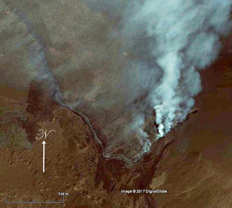 |
Figure 17. Lava and gas emerge from a fissure at Fogo on 24 November 2014, one day after the eruption began in this satellite image used by Google Earth. The fissure is located at the SW base of Pico, the cone within the Cha Caldera. Image copyright by DigitalGlobe, courtesy of Google Earth. |
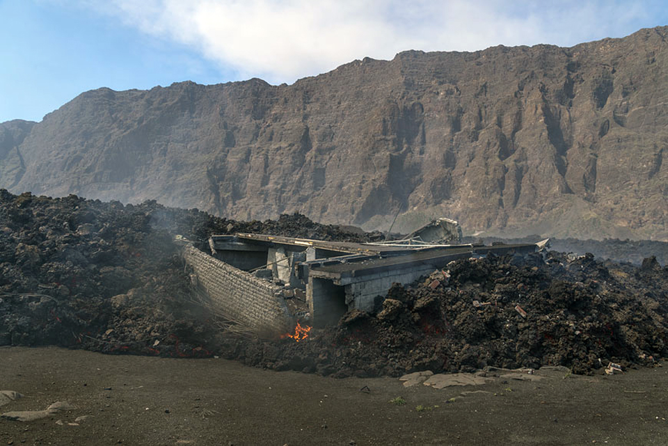 |
Figure 18. The villages of Portela and Bangaeira were destroyed by the lava flows at Fogo during late November 2014-February 2015. This image of a home in Portela trapped in a lava flow was taken between 30 November and 3 December 2014. Photo copyright by Martin Rietze, used with permission. |
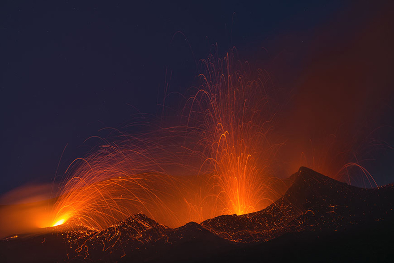 |
Figure 19. Strombolian activity at dawn on 30 November 2014 from multiple fissure vents at Fogo. Copyright by Martin Rietze, used with permission. |
The lava flows consisted of three primary lobes that traveled NNW, S, and W (BGVN 39:11, figure 8). During the earliest days of the eruption in late November, lava flowed to the NNW destroying much of Portela (figure 20 and 21) and to the S from the main fissure. The flow to the S ceased after 30 November.
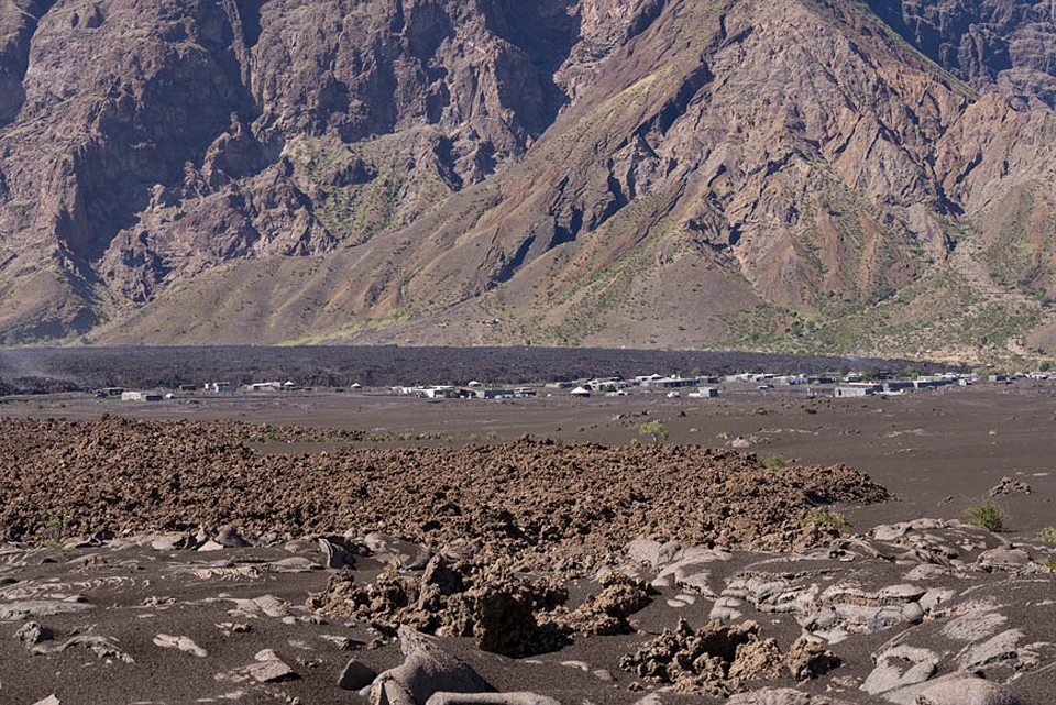 |
Figure 20. Lava advances NNW on the community of Portela at Fogo sometime during 30 November-3 December 2014. Photo copyright by Martin Rietze, used with permission. |
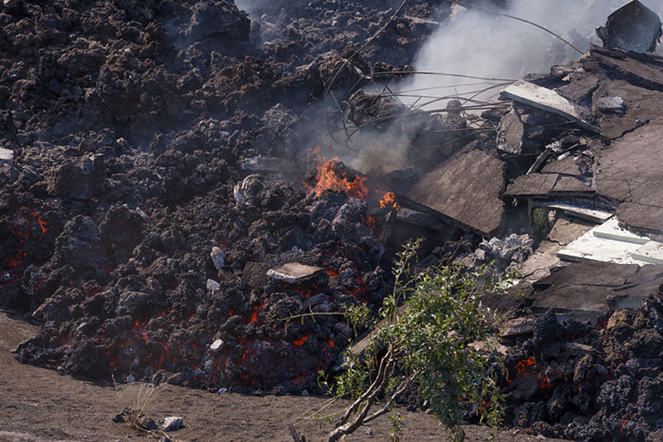 |
Figure 21. A lava flow consumes a house in the village of Portela at Fogo on 30 November 2014. Copyright by Martin Rietze, used with permission. |
The main flows continued NNW into the first week of December; they destroyed the remaining structures in Portela and caused extensive damage in Bangaeira and at the Parque Natural de Fogo headquarters (figures 22 and 23). A third lobe flowed to the W of the fissure during the second half of December, reaching the base of the 1-km-high caldera rim where it damaged farms and infrastructure in the small village of Ilhéu de Losna (see figure 16). The lava had ceased advancing by early January.
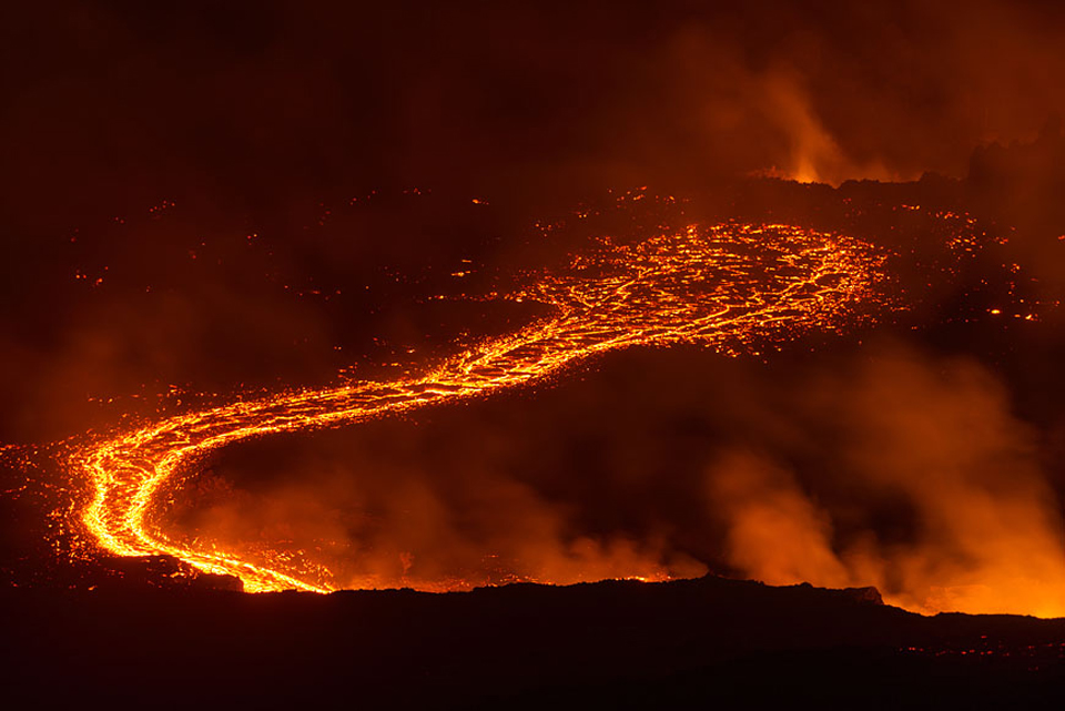 |
Figure 22. Lava flow on 1 December 2014 at Fogo emerges from a fissure vent. Photo copyright by Martin Rietze, used with permission. |
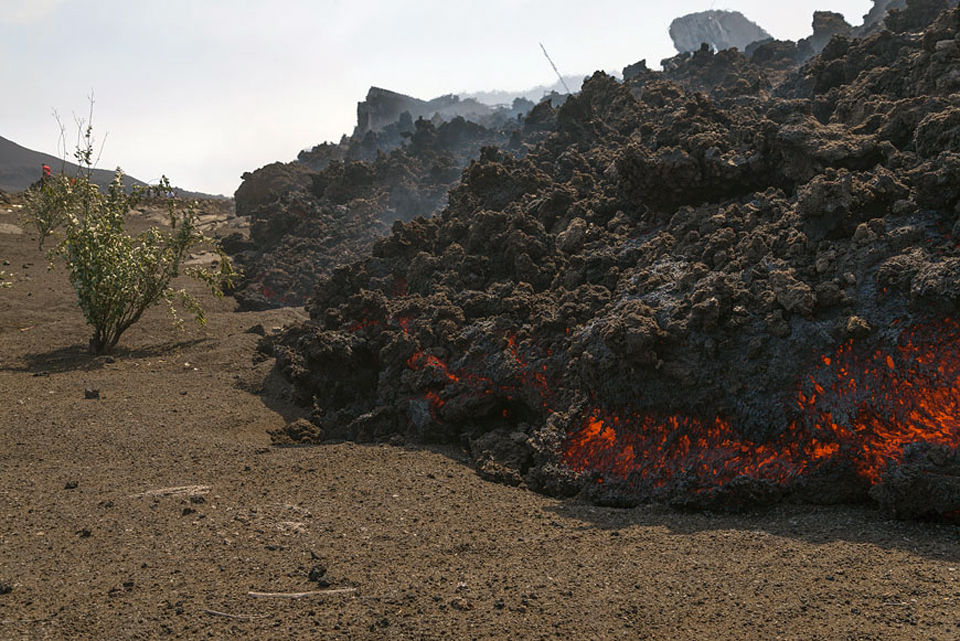 |
Figure 23. Advancing lava flow with blocky (aa) texture at Fogo during 30 November-3 December 2014. Photo copyright by Martin Rietze, used with permission. |
The MODVOLC thermal alert system issued eight thermal alerts from the lava flows (figure 24) on 23 November 2014. Tens of alerts were reported almost daily through 19 December, with a peak of 46 alerts on 30 November. For the rest of December, as many as 10 alerts a day were recorded. By January 2015, they became more intermittent, with no more than three alerts issued in any day, and they occurred on only 11 days of the month. The final two thermal alerts were recorded on 7 February 2015.
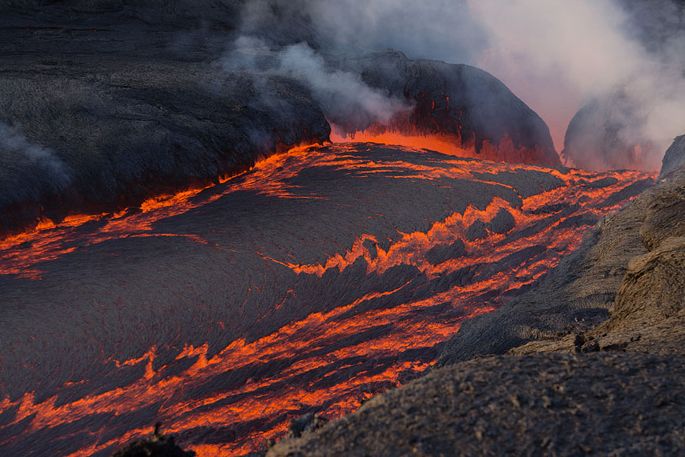 |
Figure 24. A cascade of lava flows from a fissure vent at Fogo during 30 November-3 December 2014. Photo copyright by Martin Rietze, used with permission. |
Ash emissions from the fissure vents were intermittent throughout the eruption (figures 25). The first major plume on 24 November 2014 was reported by the Toulouse VAAC as consisting largely of SO2, with very little ash. It rose to 9.1 km altitude, drifted 220 km NW, and caused minor ashfall on the flanks of the volcano. After the initial plume of mostly SO2, ash emissions from the vent were generally below 3.9 km altitude and limited to the immediate area of the island (figure 26).
 |
Figure 25. Residents flee with their belongings as ash emissions and lava flows emerge from multiple vents on the SW flank of Pico cone at Fogo during the last week of November 2014. Photo by Joao Relvas/Lusa, courtesy of The Observador, published on 30 November 2014. |
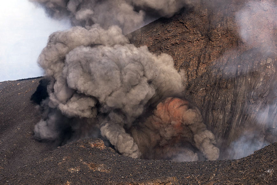 |
Figure 26. Ash explosion and incandescent material erupted from a fissure vent during 30 November-3 December 2014. Photo copyright by Martin Rietze, used with permission. |
Ash was reported rising to 2 km above the summit (4.8 km altitude) on 2 December (figure 27), and ashfall was reported near San Felipe (17 km SW). Ash and SO2 emissions decreased in mid-December; the next plume was reported on 21 December rising 800 m above the summit. Additional plumes during 30 December-2 January rose 400-900 m above the cone and occasionally sent tephra up to 40 m away. Several explosions of gas-and-ash plumes during 8-12 January produced plumes that rose up to 2 km above the summit and drifted E or SE. The largest plume, on 12 January, was very dense and dark-gray, it rose 2 km and drifted E; tephra was also ejected 50 m above the crater and was observed by people in San Felipe and other parts of the island.
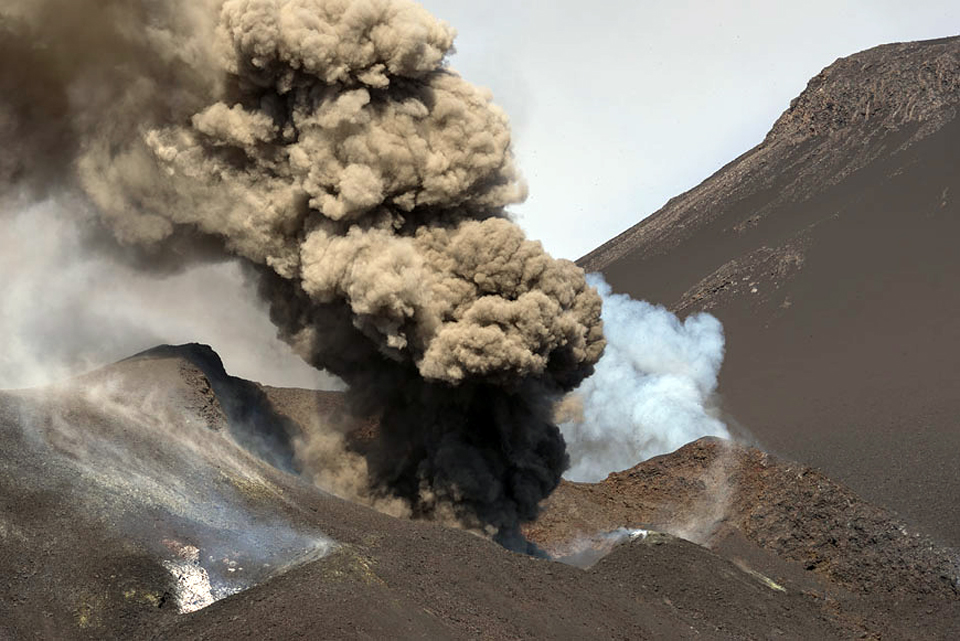 |
Figure 27. Ash emission on 2 December 2014 from the fissure vent at Fogo. The plume was reported at 2 km above the summit of Pico. Photograph copyright by Martin Rietze, used with permission. |
Satellite data on SO2 flux from Fogo corroborated the VAAC reports of the high SO2 content in the emissions, especially during the first two weeks of the eruption when Dobson Unit (DU) values greater than 2 were recorded several times, and the plume areas covered several hundred thousand square kilometers (figure 28).
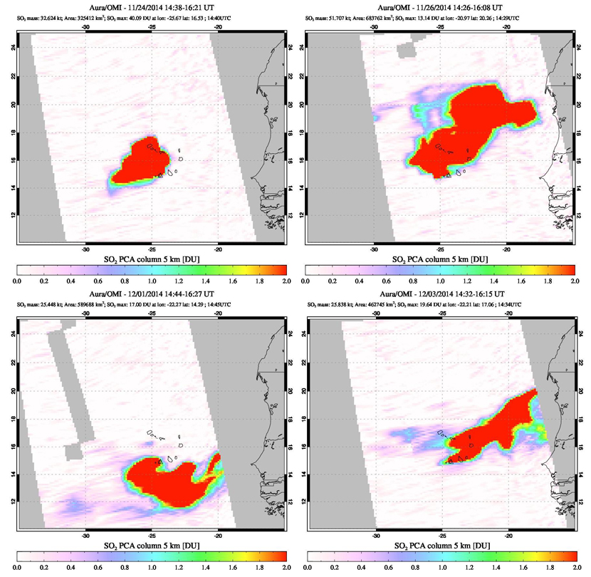 |
Figure 28. Sulfur dioxide plumes measured with the Aura Instrument on the OMI satellite show substantial amounts of SO2 released from Fogo during the eruption of November 2014-February 2015. Top Left: The SO2 plume captured on 24 November covered over 325,000 km2 and registered over 40 Dobson Units (DU), a measure of the molecular density of SO2 in the atmosphere; Top Right: the plume on 26 November covered almost 700,000 km2 and drifted N and E; Lower Left: on 1 December the 590,000 km2 plume drifted in multiple directions from the vent; Lower Right: on 3 December the large plume drifted NE and registered at almost 20 DU. Courtesy of NASA Goddard Space Flight Center. |
Geological Summary. The island of Fogo consists of a single massive stratovolcano that is the most prominent of the Cape Verde Islands. The roughly circular 25-km-wide island is truncated by a large 9-km-wide caldera that is breached to the east and has a headwall 1 km high. The caldera is located asymmetrically NE of the center of the island and was formed as a result of massive lateral collapse of the older Monte Armarelo edifice. A very youthful steep-sided central cone, Pico, rises more than 1 km above the caldera floor to about 100 m above the rim. Pico, which is capped by a 500-m-wide, 150-m-deep summit crater, was apparently in almost continuous activity from the time of Portuguese settlement in 1500 CE until around 1760. Later lava flows, some from vents on the caldera floor, reached the eastern coast below the breached caldera.
Information Contacts: Toulouse Volcanic Ash Advisory Center (VAAC), Météo-France, 42 Avenue Gaspard Coriolis, F-31057 Toulouse cedex, France (URL: http://www.meteo.fr/vaac/); Observatório Vulcanológico de Cabo Verde (OVCV), Departamento de Ciência e Tecnologia, Universidade de Cabo Verde (Uni-CV), Campus de Palmarejo, Praia, Cape Verde (URL: https://www.facebook.com/pages/Observatorio-Vulcanologico-de-Cabo-Verde-OVCV/175875102444250); Hawai'i Institute of Geophysics and Planetology (HIGP), MODVOLC Thermal Alerts System, School of Ocean and Earth Science and Technology (SOEST), Univ. of Hawai'i, 2525 Correa Road, Honolulu, HI 96822, USA (URL: http://modis.higp.hawaii.edu/); NASA Earth Observatory, EOS Project Science Office, NASA Goddard Space Flight Center, Goddard, Maryland, USA (URL: http://earthobservatory.nasa.gov/); NASA Goddard Space Flight Center (NASA/GSFC), Global Sulfur Dioxide Monitoring Page, Atmospheric Chemistry and Dynamics Laboratory, 8800 Greenbelt Road, Goddard, Maryland, USA (URL: https://so2.gsfc.nasa.gov/); Google Earth (URL: https://www.google.com/earth/); The Observador (URL: http://observador.pt/2014/11/30/erupcoes-vulcanicas-da-ilha-fogo-evoluem-para-estado-critico/); Martin Rietze, Photographer (URL: http://www.mrietze.com/web13/Fogo_f14.htm).