Report on Marapi (Indonesia) — October 2017
Bulletin of the Global Volcanism Network, vol. 42, no. 10 (October 2017)
Managing Editor: Edward Venzke.
Research and preparation by Robert Andrews.
Marapi (Indonesia) Four short ash explosions on 4 June 2017
Please cite this report as:
Global Volcanism Program, 2017. Report on Marapi (Indonesia) (Venzke, E., ed.). Bulletin of the Global Volcanism Network, 42:10. Smithsonian Institution. https://doi.org/10.5479/si.GVP.BGVN201710-261140
Marapi
Indonesia
0.38°S, 100.474°E; summit elev. 2885 m
All times are local (unless otherwise noted)
Recent activity at the large Gunung Marapi stratovolcano on Sumatra has consisted of small ash plumes, with eruptions of a single day to periods of a few months. Ashfall around the active crater rim (figure 5) and thin layers of ash deposits seen in the crater wall (figure 6) provide evidence of both the recent and very long history of explosive activity. Since 2011 there have been eruptive episodes during August-October 2011, March-May 2012, 26 September 2012, February 2014, and 14 November 2015. As reported by the Indonesian Center of Volcanology and Geological Hazard Mitigation (PVMBG), another series of explosions took place on 4 June 2017.
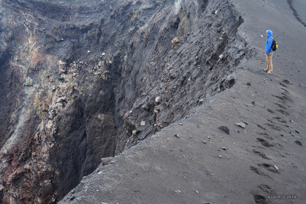 |
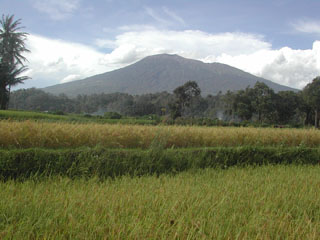
Figure 5. Photo taken at the rim of the active Verbeek Crater at Marapi on 17 April 2014. The most recent eruption prior to this photo was during 3-26 February 2014. Courtesy of Axel Drainville. |
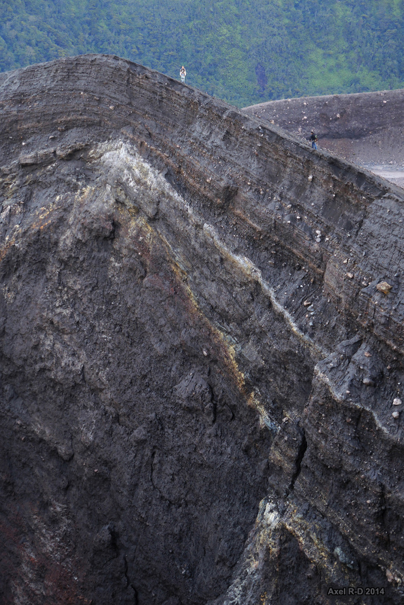 |
Figure 6. Photo showing the rim and interior wall of the Verbeek Crater at Marapi on 17 April 2014. Courtesy of Axel Drainville. |
Four explosions on 4 June lasted less than one minute each, and generated ash plumes above the summit (figure 7) and drifted E. The explosions occurred at 1001 local time (0301 UTC), 1011, 1256, and 1550. Dense ash-and-steam plumes from each explosion rose 300 m, at least 700 m, 200 m, and 250 m above the crater, respectively. The Darwin VAAC reported ash at about 3.6 km altitude extending 37 km ENE, based on satellite imagery. Ejected bombs were deposited around the crater, and minor ashfall was reported in the Pariangan District (8 km SSE), Tanah Datar Regency. Seismicity increased after the explosions. The Alert Level remained at 2 (on a scale of 1-4); residents and visitors were advised not to enter an area within 3 km of the summit.
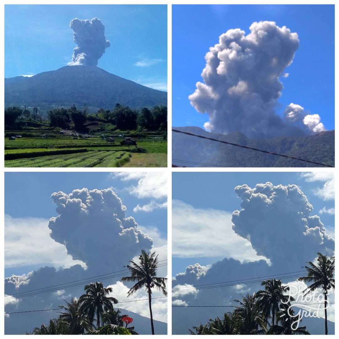 |
Figure 7. Photos of ash plumes rising from Marapi on 4 June 2017. The upper right image appears to show a smaller white plume to the right. Photos by PVMBG, posted to Twitter by Sutopo Purwo Nugroho (BNPB). |
The broad summit area with multiple craters is a popular destination for hiking expeditions. A video posted by YouTube user "SiGiTZ" documented the experience of one group during visits on 30 April 2016 and on 11 May 2017. The video provides excellent views from 2016 of the entire crater complex and of the Verbeek Crater, from which a steam-and-gas plume appears to be rising. A video posted by YouTube user "yogi antula" included a television broadcast from the Anak Borneo Channel of a video from climbers in the crater area during the 4 June explosions, taken from approximately 400-500 m away. In that video, a significant dark ash plume can be seen rising from Bungsu-Verbeek crater complex, along with a smaller white plume from a closer location. The news report was concerned with 16 hikers known to be on the mountain; there were no later reports of anyone being injured.
References: SiGiTZ, 1 August 2017, Expedisi puncak Gunung Marapi Bukittingi Sumbar Mei 2017 (URL: https://www.youtube.com/watch?v=pVxhWAbo2VA).
yogi antula, 5 June 2017, Video amatir pendakian saat Gunung Marapi Erupsi – 4 Juni 2017 (by Anak Borneo Channel) (URL: https://www.youtube.com/watch?v=8GAY6lsTLEE).
Geological Summary. Gunung Marapi, not to be confused with the better-known Merapi volcano on Java, is Sumatra's most active volcano. This massive complex stratovolcano rises 2,000 m above the Bukittinggi Plain in the Padang Highlands. A broad summit contains multiple partially overlapping summit craters constructed within the small 1.4-km-wide Bancah caldera. The summit craters are located along an ENE-WSW line, with volcanism migrating to the west. More than 50 eruptions, typically consisting of small-to-moderate explosive activity, have been recorded since the end of the 18th century; no lava flows outside the summit craters have been reported in historical time.
Information Contacts: Pusat Vulkanologi dan Mitigasi Bencana Geologi (PVMBG, also known as Indonesian Center for Volcanology and Geological Hazard Mitigation, CVGHM), Jalan Diponegoro 57, Bandung 40122, Indonesia (URL: http://www.vsi.esdm.go.id/); Badan Nasional Penanggulangan Bencana (BNPB), National Disaster Management Agency, Graha BNPB - Jl. Scout Kav.38, East Jakarta 13120, Indonesia (URL: http://www.bnpb.go.id/); Sutopo Purwo Nugroho, Badan Nasional Penanggulangan Bencana (BNPB) (URL: https://twitter.com/Sutopo_BNPB); Axel Drainville, Flickr.com, with Creative Commons license Attribution-NonCommercial 2.0 Generic (CC BY-NC 2.0, https://creativecommons.org/licenses/by-nc/2.0/) (URL: https://www.flickr.com/photos/axelrd/).