Report on Tolbachik (Russia) — October 2017
Bulletin of the Global Volcanism Network, vol. 42, no. 10 (October 2017)
Managing Editor: Edward Venzke.
Research and preparation by Paul Berger.
Tolbachik (Russia) Eruption that started in late November 2012 ends by mid-September 2013
Please cite this report as:
Global Volcanism Program, 2017. Report on Tolbachik (Russia) (Venzke, E., ed.). Bulletin of the Global Volcanism Network, 42:10. Smithsonian Institution. https://doi.org/10.5479/si.GVP.BGVN201710-300240
Tolbachik
Russia
55.832°N, 160.326°E; summit elev. 3611 m
All times are local (unless otherwise noted)
The most recent eruption began on 27 November 2012 along two fissures a few kilometers S of the main Tolbachik edifice, within the Tolbachinsky Dol lava plateau (BGVN 37:12). Monitoring is done by the Kamchatkan Volcanic Eruption Response Team (KVERT); they recorded an end date for this eruption as 15 September 2013.
Activity reported through February 2013 included Strombolian fire fountains (figure 14), voluminous lava flows on the surface (figure 15 and 16) and under the ice and snow cover (figure 17), ash explosions, and the building of cinder cones (BGVN 37:12). Satellite imagery in early June 2013 revealed both a lava pond at the active vent and a large lava flow lower down the flank, with multiple flow-front breakouts (figure 18). Cinder cones continued to grow along the S fissure through 16-22 August 2013, and lava flows remained active (figure 19), but then gas-and-ash plumes weakened and seismicity decreased during the last week of the month (BGVN 38:08).
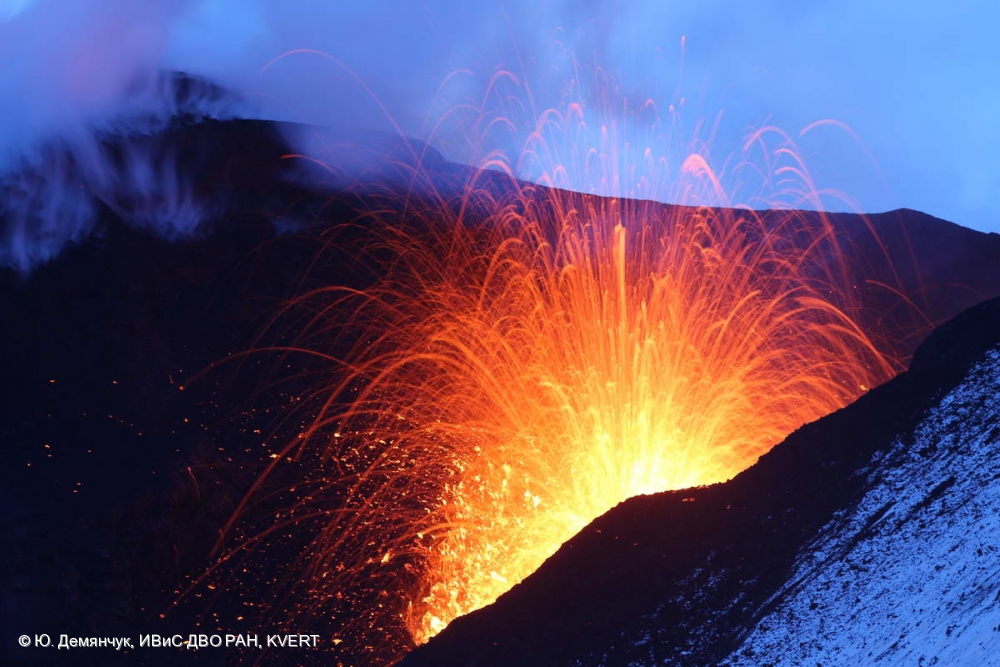 |
Figure 14. Lava fountain in the cinder cone at Tolbachik on 24 January 2013. Photo by Yu. Demyanchuk; courtesy of IVS FEB RAS and KVERT. |
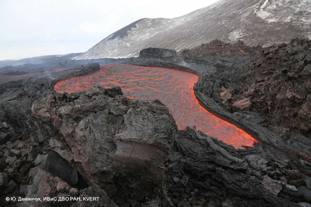 |
Figure 15. Photo of lava flow at Tolbachik on 25 January 2013. Photo by Yu. Demyanchuk; courtesy of IVS FEB RAS and KVERT. |
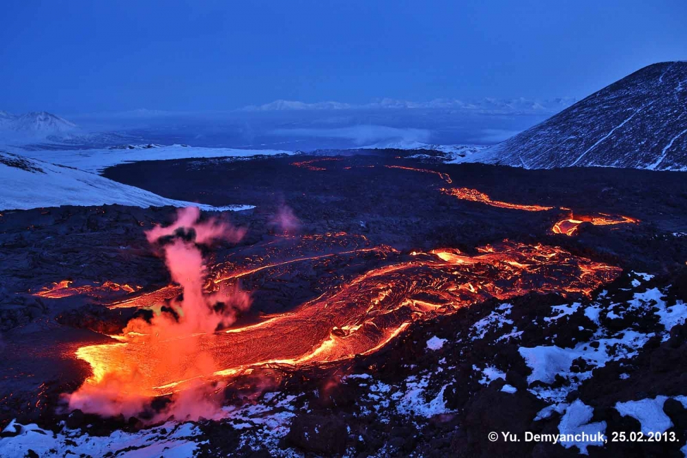 |
Figure 16. Lava flows moving ESE at Tolbachik on 25 February 2013. Photo by Yu. Demyanchuk; courtesy of IVS FEB RAS and KVERT. |
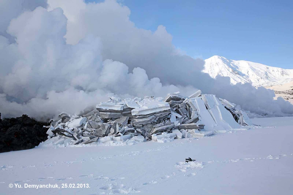 |
Figure 17. Photo of a lava flow intruding under deep snow at Tolbachik on 25 February 2013. Photo by Yu. Demyanchuk; courtesy of IVS FEB RAS and KVERT. |
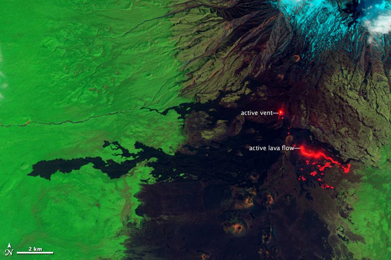 |
Figure 18. False-color image of Tolbachinsky in shortwave infrared and near-infrared light (combined with green light), taken on 6 June 2013 by the Advanced Land Imager on the Earth Observing-1 satellite. Hot surfaces glow in shortwave infrared wavelengths. The active vent and lava flow are bright red, along with scattered lava "breakouts"at the front of the flow. High temperature surfaces in the scene also glow in near infrared light, revealing a lava pond in the active vent and fluid lava in the center of the lava flow. Courtesy of NASA (image by Jesse Allen and Robert Simmon, caption by Robert Simmon). |
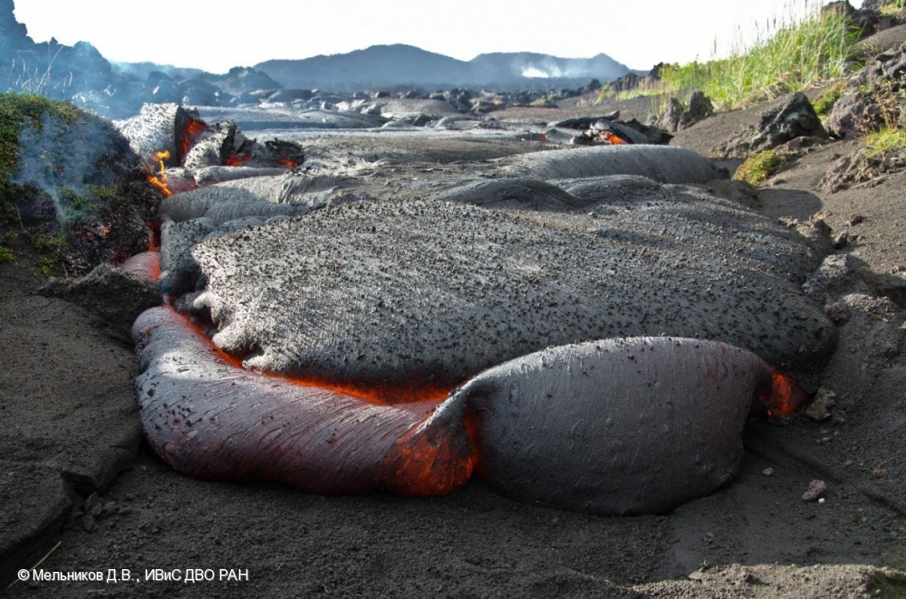 |
Figure 19. Photo of lava flow front adjacent to the Kruglenkaya slag cone at Tolbachik on 16 August 2013. Photo by D.V. Melnikov; courtesy of IVS FEB RAS and KVERT. |
Seismicity continued to decrease during 22-24 August 2013, and KVERT noted on 27 August that no incandescence had been seen in recent days, and there were no current ash plumes. Satellite data did still show a large thermal anomaly in the northern area of Tolbachinsky Dol, which KVERT attributed to the lava flows remaining hot. The MODIS thermal anomaly data recorded in the MODVOLC system identified the latest hotspot on 27 August 2013. According to the Kamchatkan Volcanic Eruption Response Team (KVERT), the Aviation Color Code (ACC) was lowered from Orange to Yellow on 27 August 2013.
When the ACC was lowered to Green on 31 January 2014, KVERT reported that weak seismic activity and episodes of tremor continued, gas-and-steam activity was sometimes observed, and satellite data continued to show a weak thermal anomaly. However, they also stated that "probably its active phase was finishing in September 2013." The KVERT website recorded an end date of 15 September 2013. The new lava flows were still noticeable in visible satellite imagery more than a year after the eruption ended (figure 20).
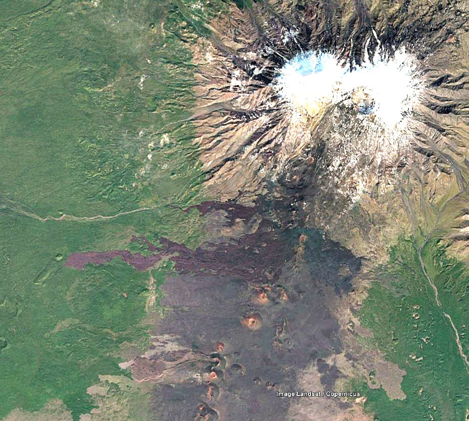 |
Figure 20. Satellite image from Landsat/Copernicus showing the final extent of new lava flows on the SSW flank of Tolbachik on 30 December 2014. The new lava flows extend across the center of the image, with the main edifice at top right. Color and contrast have been adjusted to enhance the contrast between fresh darker lava and faded older deposits. Courtesy of Google Earth. |
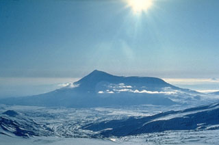
Geological Summary. The massive Tolbachik volcano is located at the southern end of the Kliuchevskaya volcano group. The massif is composed of two overlapping, but morphologically distinct, volcanoes. The flat-topped Plosky Tolbachik shield volcano with its nested Holocene calderas up to 3 km in diameter is located east of the older and higher sharp-topped Ostry Tolbachik stratovolcano. The summit caldera at Plosky Tolbachik was formed in association with major lava effusion about 6,500 years ago and simultaneously with a major southward-directed sector collapse of Ostry Tolbachik. Long rift zones extending NE and SSW of the volcano have erupted voluminous basaltic lava flows during the Holocene, with activity during the past two thousand years being confined to the narrow axial zone of the rifts. The 1975-76 eruption originating from the SSW-flank fissure system and the summit was the largest historical basaltic eruption in Kamchatka.
Information Contacts: Kamchatka Volcanic Eruptions Response Team (KVERT), Far Eastern Branch, Russian Academy of Sciences, 9 Piip Blvd., Petropavlovsk-Kamchatsky, 683006, Russia (URL: http://www.kscnet.ru/ivs/kvert/); Institute of Volcanology and Seismology, Far Eastern Branch, Russian Academy of Sciences (IVS FEB RAS), 9 Piip Blvd., Petropavlovsk-Kamchatsky 683006, Russia (URL: http://www.kscnet.ru/ivs/eng/); Hawai'i Institute of Geophysics and Planetology (HIGP) - MODVOLC Thermal Alerts System, School of Ocean and Earth Science and Technology (SOEST), Univ. of Hawai'i, 2525 Correa Road, Honolulu, HI 96822, USA (URL: http://modis.higp.hawaii.edu/); NASA Earth Observatory, EOS Project Science Office, NASA Goddard Space Flight Center, Goddard, Maryland, USA (URL: http://earthobservatory.nasa.gov/); Google Earth (URL: https://www.google.com/earth/).