Report on Kirishimayama (Japan) — January 2018

Bulletin of the Global Volcanism Network, vol. 43, no. 1 (January 2018)
Managing Editor: Edward Venzke.
Research and preparation by Paul Berger.
Kirishimayama (Japan) Explosive eruption with ash plumes in October 2017
Please cite this report as:
Global Volcanism Program, 2018. Report on Kirishimayama (Japan) (Venzke, E., ed.). Bulletin of the Global Volcanism Network, 43:1. Smithsonian Institution. https://doi.org/10.5479/si.GVP.BGVN201801-282090
Kirishimayama
Japan
31.934°N, 130.862°E; summit elev. 1700 m
All times are local (unless otherwise noted)
After an explosive eruption during January-September 2011, Shinmoe-dake (Shinmoedake), a stratovolcano of the Kirishimayama volcano group, was quiet except for gas-and-steam plumes and slowly decreasing seismicity that returned to baseline levels by May 2012 (BGVN 37:07). The following report summarizes events through December 2017, and relies primarily on reports from the Japan Meteorological Agency (JMA).
On 22 October 2013, JMA reported that no eruptions had been detected at the volcano since the eruption on 7 September 2011. Earthquake activity and sulfur dioxide emissions were both below the detection limit. The Alert Level was lowered from 3 to 2 (on a scale of 1-5).
According to JMA, an eruption began at 0534 on 11 October 2017, prompting the agency to raise the Alert Level to 3 (figure 21). Ash plumes rose 300 m above the crater rim (2 km altitude) and drifted NE. Volcanic tremor amplitude increased and inflation was detected. Ashfall was noted in at least four towns in the Miyazaki (to the E) and Kagoshima (to the SW) prefectures. Based on JMA notices, pilot observations, and satellite data, the Tokyo Volcanic Ash Advisory Center (VAAC) reported that ash plumes rose to an altitude of 1.8-2.1 km on 11 October and 3.4 km on 12 October.
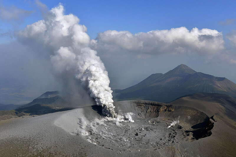 |
Figure 21. An ash plume rises from the Shinmoedake crater at Kirishimayama after its eruption on 11 October 2017. Courtesy of Tomoaki Ito / Kyodo News. |
Gas measurements taken during field surveys on 12 and 13 October showed that the sulfur dioxide flux was 1,400 tonnes/day, an increase from 800 tonnes/day measured on 11 October. Volcanic tremor fluctuated but the amplitude was slightly lower. During 0823-1420 on 14 October, an event produced a tall plume which rose 2.3 km above the crater rim. Another event, at 1505, generated a grayish-white plume that rose 1 km and then blended into the weather clouds. Ashfall was reported in Kirishima (22 km SW) in the Kagoshima prefecture, in Kobayashi (14 km NE) in the Miyazaki prefecture, and reaching as far as Hyuga city (92 km NE). An increase in low-frequency earthquakes was recorded on 16 October.
The eruption lasted almost continuously until the morning of 17 October. The eruption plume usually rose several hundred meters about the crater rim, though on 14 October the plume rose as high as 2.3 km. Sulfur dioxide flux exceeded 10,000 tonnes/day. Cloudy weather conditions prevented webcam views during 19-20 October. Plumes rose 200-600 m on 21, 23, and 24 October. During an overflight on 24 October, scientists observed a white plume rising from the active vent on the E side of the crater, and puddles in multiple low areas of the crater.
Activity during 25 October-20 November 2017 activity continued to be slightly elevated. White plumes rose 100-500 m above the crater rim, though weather clouds sometimes prevented visual observations. Almost daily field surveys by JMA revealed no particular changes in the fumarolic and fissure areas near the cracks on the W flank, or to the thermally anomalous zone below the crack. Sulfur dioxide fluxes were as high as 200 tonnes/day. The Alert Level remained at 3.
Geological Summary. Kirishimayama is a large group of more than 20 Quaternary volcanoes located north of Kagoshima Bay. The late-Pleistocene to Holocene dominantly andesitic group consists of stratovolcanoes, pyroclastic cones, maars, and underlying shield volcanoes located over an area of 20 x 30 km. The larger stratovolcanoes are scattered throughout the field, with the centrally located Karakunidake being the highest. Onamiike and Miike, the two largest maars, are located SW of Karakunidake and at its far eastern end, respectively. Holocene eruptions have been concentrated along an E-W line of vents from Miike to Ohachi, and at Shinmoedake to the NE. Frequent small-to-moderate explosive eruptions have been recorded since the 8th century.
Information Contacts: Japan Meteorological Agency (JMA), Otemachi, 1-3-4, Chiyoda-ku Tokyo 100-8122, Japan (URL: http://www.jma.go.jp/); Tokyo Volcanic Ash Advisory Center (VAAC), 1-3-4 Otemachi, Chiyoda-ku, Tokyo, Japan (URL: http://ds.data.jma.go.jp/svd/vaac/data/); Associated Press (URL: https://www.ap.org/en-us); Kyodo News (URL: https://english.kyodonews.net).