Report on Tinakula (Solomon Islands) — February 2018
Bulletin of the Global Volcanism Network, vol. 43, no. 2 (February 2018)
Managing Editor: Edward Venzke.
Edited by A. Elizabeth Crafford.
Tinakula (Solomon Islands) Short-lived ash emission and large SO2 plume 21-26 October 2017; historical eruption accounts
Please cite this report as:
Global Volcanism Program, 2018. Report on Tinakula (Solomon Islands) (Crafford, A.E., and Venzke, E., eds.). Bulletin of the Global Volcanism Network, 43:2. Smithsonian Institution. https://doi.org/10.5479/si.GVP.BGVN201802-256010
Tinakula
Solomon Islands
10.386°S, 165.804°E; summit elev. 796 m
All times are local (unless otherwise noted)
Remote Tinakula lies 100 km NE of the Solomon Trench at the N end of the Santa Cruz Islands, part of the country of the Solomon Islands, which generally lie 400 km to the W. It has been uninhabited since an eruption with lava flows and ash explosions in 1971 when the small population was evacuated (CSLP 87-71). The nearest inhabitants live on Te Motu (Trevanion) Island (about 30 km S), Nupani (40 km N), and the Reef Islands (60 km E); they occasionally report explosion noises from Tinakula. Ashfall from larger explosions has historically reached these islands. The last reported evidence of activity came from MODVOLC thermal alerts between August 2010 and October 2012, and observations of incandescent lava blocks rolling into the sea in May 2012. A new eruptive episode with a large ash explosion and substantial SO2 plume during 21-26 October 2017 is reported below, along with newly available historical newspaper accounts of earlier eruptions.
Reports of ash plumes are issued by the Wellington Volcanic Ash Advisory Center (VAAC); the National Disaster Management Office (NDMO) of the Solomon Islands Government also issues situation reports when significant activity is reported. Satellite data from infrared, visual, and SO2 monitoring instruments are an important source of information for this remote volcano. News reports from local (and social) media are often the only sources of information for the smaller events. Recently identified 19th- and 20th-century newspaper accounts of eruptive activity witnessed by sailors passing nearby is a valuable new resource for previously unreported events.
Eruption of 21-26 October 2017. Reports of a substantial explosion with an ash plume from Tinakula appeared on social media and in the local press during 22-26 October 2017. Staff from the Lata Met Service Office approached the island by boat on 23 October to make direct observations (figures 17-19). A video clip from the Himawari8 Satellite showing the ash plume explosion was posted by Stephan Armbruster on Twitter on 22 October. The Solomon Islands NDMO issued a situation report on 26 October showing ashfall covering vegetation on the island. According to the NDMO, ashfall was concentrated on the island, although a small amount of ash drifted SE and was reported to briefly contaminate drinking water in several communities in the nearby Reef Islands (60 km ENE) . Ashfall was also reported on Fenualoa Island (50 km ENE) (Radio New Zealand). The eruption was categorized by NMDO as a VEI 3. A team of geologists from NDMO brought seismic monitoring equipment to Tinakula in early November, and measured a high frequency volcanic tremor on 5 November 2017.
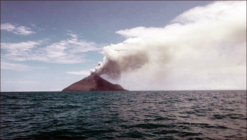 |
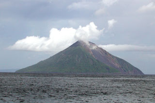
Figure 17. View from the SE of the eruption at Tinakula on 23 October 2017 during a site visit by staff from the Lata Office of the Solomon Islands Meteorological Service. Photo by Okano Gamara. |
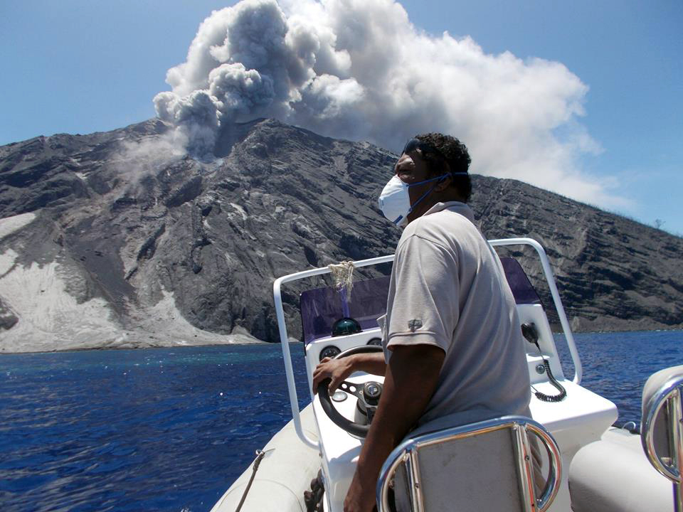 |
Figure 18. Ash and steam emissions rose from Tinakula on 23 October 2017 during a site visit by staff from the Lata Office of the Solomon Islands Meteorological Service. Photo by Okano Gamara. |
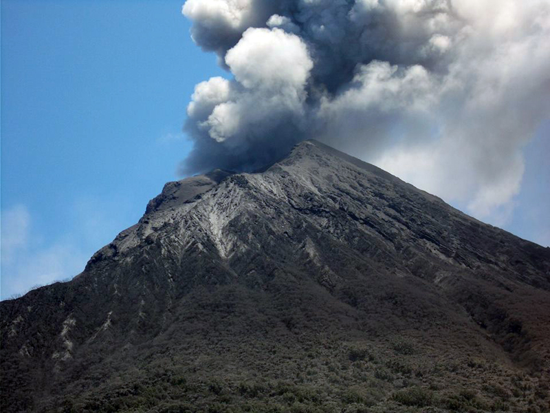 |
Figure 19. Ash emission from Tinakula on 23 October 2017 during a site visit by staff from the Lata Office of the Solomon Islands Meteorological Service. Photo by Okano Gamara. |
The Wellington VAAC first reported an ash plume visible in satellite imagery shortly after midnight (UTC) on 21 October 2017. The plume was estimated to be at 4.6 km altitude and drifting N. About 90 minutes later they reported a second eruption with a much higher plume drifting SE at 10.7 km altitude using IR imagery cloud top temperatures to estimate the altitude. They reported ongoing ash emissions visible in satellite imagery drifting SE at 6.1 km altitude throughout the morning, dropping to 3 km altitude by the end of the day. The following day, 22 October, intermittent ash emissions were reported at 3.7 km altitude moving E. By that afternoon, they had dropped to 2.4 km, and had lowered to 1.8 km by late on 23 October. Ongoing low-level ash emission (2.1 km altitude) continued through 25 October; by early on 26 October, there was no further evidence of ongoing activity.
No MODVOLC thermal alerts were associated with this event, but there was a brief MIROVA signal from the MODIS infrared data during 20-23 October 2017 (figure 20). A major SO2 plume was released from Tinakula on 21 October, and a smaller one was recorded on 28 October as well (figure 21).
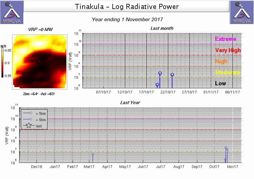 |
Figure 20. Moderate thermal signals were recorded from Tinakula on 20 and 23 October 2017 (top graph) by the MIROVA system that captures MODIS infrared satellite data. Another signal reported during the first week of March 2017 (bottom graph) could also have been an eruptive event, but no other corroborating evidence is available. Courtesy of MIROVA. |
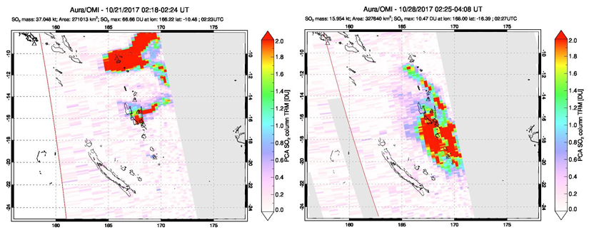 |
Figure 21. Major SO2 plumes from Tinakula and the Vanatu volcanoes of Ambae and Ambrym were released during October 2017. A substantial SO2 plume drifted in several directions from Tinakula on 21 October 2017 (left). Much smaller plumes are also visible from Ambae and Ambrym which are located farther south. On 28 October (right), a smaller SO2 plume was drifting SE from Tinakula while much larger plumes were apparent from Ambae and Ambrym. Data gathered by the OMI instrument on the Aura Satellite. Courtesy of NASA Goddard Space Flight Center. |
Summary of activity during 1971-2012. After the 1971 eruption, intermittent ash emissions, lava bombs, and pyroclastic flows were reported by geologists and sailors passing nearby in 1984, 1985, 1989-1990, 1995, and 1999. Infrared MODIS thermal data was first reported as MODVOLC thermal alerts beginning in 2000 and has provided satellite-based confirmation of thermal activity since then. Months with thermal activity included February 2000-May 2001, February 2006-November 2007, September-November 2008, August 2009, and January 2010-October 2012 (figure 22). No additional thermal alerts were issued through 2017. Since 2004, SO2 data has been gathered by satellite instruments and processed by NASA Goddard Space Flight Center; in February and April 2006 small SO2 plumes were recorded (figure 23).
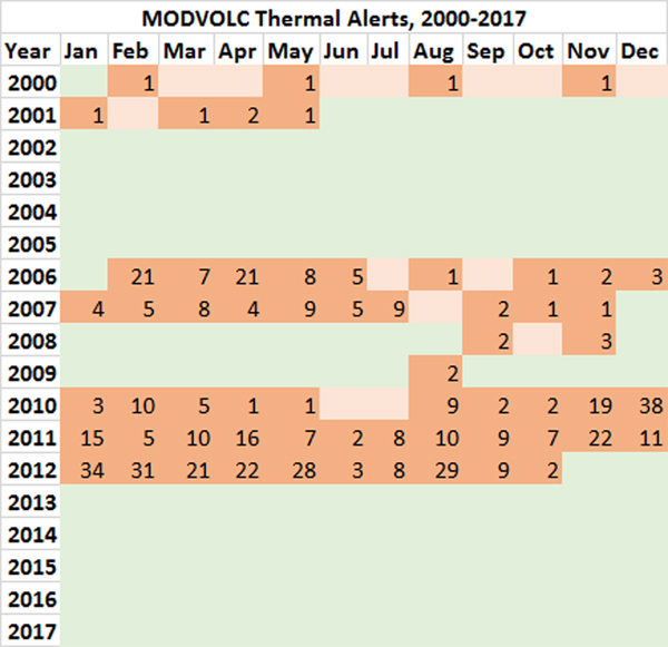 |
Figure 22. Months with MODVOLC thermal alerts from MODIS infrared data for Tinakula, during January 2000-December 2017. The orange boxes indicate months where at least one MODVOLC thermal alert was issued; the number of alerts is indicated inside the square. Months highlighted in green represent contiguous periods of time of three months or greater with no recorded MODVOLC thermal alerts. Pale orange squares indicate months with no MODVOLC thermal alerts issued, but within a three-month buffer of an earlier thermal alert. Data courtesy of MODVOLC. |
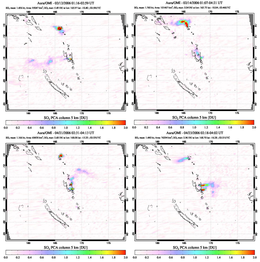 |
Figure 23. SO2 emission data captured by the OMI instrument on the Aura satellite indicated small plumes from Tinakula (top center of images) on 12 and 14 February 2006 (top) and 21 and 23 April 2006 (bottom). Small plumes were also visible from Ambrym on 12 February, and from Ambae and Ambrym on 14 February and 21 and 23 April 2006. Courtesy of NASA Goddard Space Flight Center. |
Eruption reports during 1868-1932. Reports of eruptions at Tinakula between 1868 and 1932 have recently been found in 19th and 20th century newspaper accounts from Australia and New Zealand (table 6). The accounts describe incandescence, water discoloration of the sea, explosions, ash plumes, and lava flows extending from the summit to the ocean.
Table 6. Newly discovered historical newspaper accounts of volcanic activity from ships passing near Tinakula between 1868 and 1932. This is not a full eruptive history for the time period. Online links provided in the References section. Courtesy of Steve Hutcheon.
| Date | Account | Reference |
| 17 Oct 1868 | Passed Volcano Island, one of the South (sic) Cruz group, on the 17th of October. It was then in active operation, vomiting forth immense volumes of fire and smoke. Note; Volcano Island is another name for Tinakula. | The Age, Melbourne, 10 November 1868, page 2b; also in The Argus, Melbourne, 10 November 1868, page 4b |
| 9 Oct 1869 | On the 9th October sighted three low islands, also Volcano Island; the discharge from the latter was plainly visible. | The Empire, Sydney, 27 October 1869, page 2a |
| 29/30 Nov 1871 | During the night, the active volcano, Tinakula, was passed. Large masses of red hot lava were emitted; and the sight is described as being very imposing and grand. | The Sydney Morning Herald, 19 February 1872, page 6a |
| 20 Jun 1887 | When his vessel was off the Santa Cruz group Mount Tinakula became an active volcano. It broke out at 4 o'clock on the morning of June 20 and viewed from the ship's deck presented a most grand spectacle. The water for miles round was of a pea green color and had the appearance of being very shallow. | The Daily Telegraph, Sydney, NSW, 20 July 1887, page 4f |
| ~23 Aug 1910 | Tinakula Island was found to be in an active state of eruption, and presented a fine sight. The ship Tambo departed Tarawa 19 August and arrived in Sydney on 31 August 1910. | The Daily Telegraph, Sydney, NSW, 1 September 1910, page 7a |
| 2/3 May 1932 | The steamer passed within half a mile of the active volcano of Tinakula. It was at night, and the passengers obtained a remarkable view of the red hot lava streams flowing from the summit, which is 2000 ft. high, to the water's edge. Three eruptions occurred while the vessel was within view of the island, each preceded by an explosion which sounded like thunder. | The New Zealand Herald, Auckland, NZ, 27 June 1932, page 6a; The Auckland Star, 10 September 1932 page 1h (Supplement) |
References. The Age (Melbourne, Victoria) 10 November 1868, page 2b (URL: http://nla.gov.au/nla.news-article177002744).
The Empire (Sydney, NSW) 27 October 1869, page 2a, (URL: http://nla.gov.au/nla.news-article60895166).
The Sydney Morning Herald (NSW) 19 Februay 1872, page 6a (URL: http://nla.gov.au/nla.news-article13252748).
The Daily Telegraph (Sydney, NSW) 1887 20 July, page 4f (URL: http://nla.gov.au/nla.news-article239817295).
The Daily Telegraph (Sydney, NSW) 1 September 1910, page 7a (URL: http://nla.gov.au/nla.news-article237993807; http://nla.gov.au/nla.news-article15183461 ).
The New Zealand Herald (Auckland, NZ) 27 June 1932, page 6a (URL: https://paperspast.natlib.govt.nz/newspapers/NZH19320627.2.19 ).
The Auckland Star (NZ) 10 September 1932, page 1h (Supplement) (URL: https://paperspast.natlib.govt.nz/newspapers/AS19320910.2.180.6 ).
Geological Summary. The small 3.5-km-wide island of Tinakula is the exposed summit of a massive stratovolcano at the NW end of the Santa Cruz islands. It has a breached summit crater that extends from the summit to below sea level. Landslides enlarged this scarp in 1965, creating an embayment on the NW coast. The Mendana cone is located on the SE side. The dominantly andesitic volcano has frequently been observed in eruption since the era of Spanish exploration began in 1595. In about 1840, an explosive eruption apparently produced pyroclastic flows that swept all sides of the island, killing its inhabitants. Recorded eruptions have frequently originated from a cone constructed within the large breached crater. These have left the upper flanks and the steep apron of lava flows and volcaniclastic debris within the breach unvegetated.
Information Contacts: National Disaster Management Office (NDMO), Solomon Islands Government, Prince Philip Highway, Ranadi, Solomon Islands (URL: http://www.ndmo.gov.sb); Wellington Volcanic Ash Advisory Centre (VAAC), Meteorological Service of New Zealand Ltd (MetService), PO Box 722, Wellington, New Zealand (URL: http://www.metservice.com/vaac/, http://www.ssd.noaa.gov/VAAC/OTH/NZ/messages.html); Hawai'i Institute of Geophysics and Planetology (HIGP), MODVOLC Thermal Alerts System, School of Ocean and Earth Science and Technology (SOEST), Univ. of Hawai'i, 2525 Correa Road, Honolulu, HI 96822, USA (URL: http://modis.higp.hawaii.edu/); MIROVA (Middle InfraRed Observation of Volcanic Activity), a collaborative project between the Universities of Turin and Florence (Italy) supported by the Centre for Volcanic Risk of the Italian Civil Protection Department (URL: http://www.mirovaweb.it/); NASA Goddard Space Flight Center (NASA/GSFC), Global Sulfur Dioxide Monitoring Page, Atmospheric Chemistry and Dynamics Laboratory, 8800 Greenbelt Road, Goddard, Maryland, USA (URL: http://so2.gsfc.nasa.gov/index.html ); Radio New Zealand (URL: http://www.radionz.co.nz/international/pacific-news/342267/solomons-pm-calls-for-calm-in-communities-close-to-volcano); Solomon Islands Broadcasting Corporation, SIBC Voice of the Nation, Honiara, Solomon Islands (URL: http://www.sibconline.com.sb/no-its-not-snow-in-the-solomons-its-ash-from-the-tinakula-volcano/); Andy Prata, AIRES Atmospheric Industrial Research and Environmental Solutions, Melbourne, Australia (URL: https://www.aires.space/, https://twitter.com/andyprata/status/922177129944625157); Gamara Okzman Bencarson, Facebook.