Report on Ambrym (Vanuatu) — February 2018
Bulletin of the Global Volcanism Network, vol. 43, no. 2 (February 2018)
Managing Editor: Edward Venzke.
Research and preparation by Paul Berger.
Ambrym (Vanuatu) Elevated seismicity in early August 2017-early November 2017, lava lakes remain
Please cite this report as:
Global Volcanism Program, 2018. Report on Ambrym (Vanuatu) (Venzke, E., ed.). Bulletin of the Global Volcanism Network, 43:2. Smithsonian Institution. https://doi.org/10.5479/si.GVP.BGVN201802-257040
Ambrym
Vanuatu
16.25°S, 168.12°E; summit elev. 1334 m
All times are local (unless otherwise noted)
Occasional weak eruptions and low-level ash emissions are typical of activity at Ambrym. The most recent ash emission was on 3 April 2017 (BGVN 42:05). The current report summarizes activity from late April through December 2017.
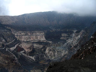
On 30 August 2017, the Vanuatu Meteorology and Geo-Hazards Department (VMGD) reported that "drastic changes" at Ambrym prompted an increase in the Alert Level from 2 to 3 (on a scale of 0-5). Areas deemed hazardous were near and around the active vents (Benbow, Maben-Mbwelesu, Niri-Mbwelesu and Mbwelesu), and in downwind areas prone to ashfall. According to a news report (Radio New Zealand), a representative of VMGD indicated that the Alert Level change was based on increased seismicity detected since the beginning of August, but which became more notable on 25 August.
According to VMGD, aerial observations on 24 and 30 September, and 1 and 6 October, combined with analysis of seismic data, confirmed that minor eruptive activity within the caldera was characterized by hot volcanic gas and steam emissions. Areas deemed hazardous were within a 2-km radius from Benbow Crater and a 3-km radius from Marum Crater.
A news report (The Vanuatu Independent) quoted an official from VMGD as stating that on 8 November 2017 at 0500, the Niri-Mbwelesu eruptive vent emitted a minor ash plume. On 7 December 2017, VGO lowered the Alert Level to 2, noting that activity had stabilized by the end of November and was characterized by gas-and-steam emissions. Seismicity had also declined. The report reminded the public to stay outside of the Permanent Danger Zone, defined as a 1-km radius from Benbow Crater and a 2.7-km radius from Marum Crater.
During the reporting period, thermal anomalies based on MODIS satellite instruments and analyzed using the MODVOLC algorithm, continued to be numerous every month, possibly reflecting lava lakes in Benbow and Marum craters. The MIROVA (Middle InfraRed Observation of Volcanic Activity) system also detected numerous hotspots every month within 5 km of the volcano.
Geological Summary. Ambrym, a large basaltic volcano with a 12-km-wide caldera, is one of the most active volcanoes of the New Hebrides Arc. A thick, almost exclusively pyroclastic sequence, initially dacitic then basaltic, overlies lava flows of a pre-caldera shield volcano. The caldera was formed during a major Plinian eruption with dacitic pyroclastic flows about 1,900 years ago. Post-caldera eruptions, primarily from Marum and Benbow cones, have partially filled the caldera floor and produced lava flows that ponded on the floor or overflowed through gaps in the caldera rim. Post-caldera eruptions have also formed a series of scoria cones and maars along a fissure system oriented ENE-WSW. Eruptions have apparently occurred almost yearly during historical time from cones within the caldera or from flank vents. However, from 1850 to 1950, reporting was mostly limited to extra-caldera eruptions that would have affected local populations.
Information Contacts: Geo-Hazards Division, Vanuatu Meteorology and Geo-Hazards Department, Ministry of Climate Change Adaptation, Meteorology, Geo-Hazards, Energy, Environment and Disaster Management, Private Mail Bag 9054, Lini Highway, Port Vila, Vanuatu (URL: http://www.vmgd.gov.vu/, https://www.facebook.com/VanuatuGeohazardsObservatory/); Radio New Zealand (URL: https://www.radionz.co.nz); The Vanuatu Independent (URL: https://vanuatuindependent.com/); Hawai'i Institute of Geophysics and Planetology (HIGP), MODVOLC Thermal Alerts System, School of Ocean and Earth Science and Technology (SOEST), Univ. of Hawai'i, 2525 Correa Road, Honolulu, HI 96822, USA (URL: http://modis.higp.hawaii.edu/); Middle InfraRed Observation of Volcanic Activity (MIROVA), Mirova (collaborative project between the Universities of Turin and Florence, Italy)(URL: http://www.mirovaweb.it).