Report on Fernandina (Ecuador) — February 2018

Bulletin of the Global Volcanism Network, vol. 43, no. 2 (February 2018)
Managing Editor: Edward Venzke.
Edited by A. Elizabeth Crafford.
Fernandina (Ecuador) Brief fissure eruption sends lava flow down the SW flank in early September 2017
Please cite this report as:
Global Volcanism Program, 2018. Report on Fernandina (Ecuador) (Crafford, A.E., and Venzke, E., eds.). Bulletin of the Global Volcanism Network, 43:2. Smithsonian Institution. https://doi.org/10.5479/si.GVP.BGVN201802-353010
Fernandina
Ecuador
0.37°S, 91.55°W; summit elev. 1476 m
All times are local (unless otherwise noted)
Eruptions at Fernandina Island in the Galapagos often occur from vents located around the caldera rim along boundary faults and fissures, and occasionally from side vents on the flank. The last eruption in 2009 generated fountaining basaltic lava along several fissure vents. Lava flowed down the SW flank and entered the sea for a few weeks during April 2009. A new eruption began on 4 September 2017 after eight years of no surface activity, and lasted for about one week. Information about this new eruption was provided by Ecuador's Institudo Geofisica, Escuela Politécnica Nacional (IG-EPN), the Dirección del Parque Nacional Galápagos (DPNG), the Washington Volcanic Ash Advisory Center (VAAC), and several sources of satellite data.
A brief fissure vent eruption began on 4 September 2017 at Fernandina, located at the SW rim of the caldera. Small amounts of ash were noted in the plume that rose 2.5 km, but most of the emission was steam and SO2. Vegetation fires were ignited on the SW flank, but lava did not reach the ocean. There was no sign of volcanic activity within the summit crater. A significant area with thermal anomalies was seen in infrared satellite data through 7 September.
Eruption of early September 2017. After eight years of little activity, Fernandina (La Cumbre) began a new eruptive phase on 4 September 2017, at approximately 1225 (Galápagos time) (figure 22). Inflation between March 2015 and September 2017 was 17 cm centered on the caldera; 5 cm of that inflation occurred in the last two months before the eruption (figure 23).
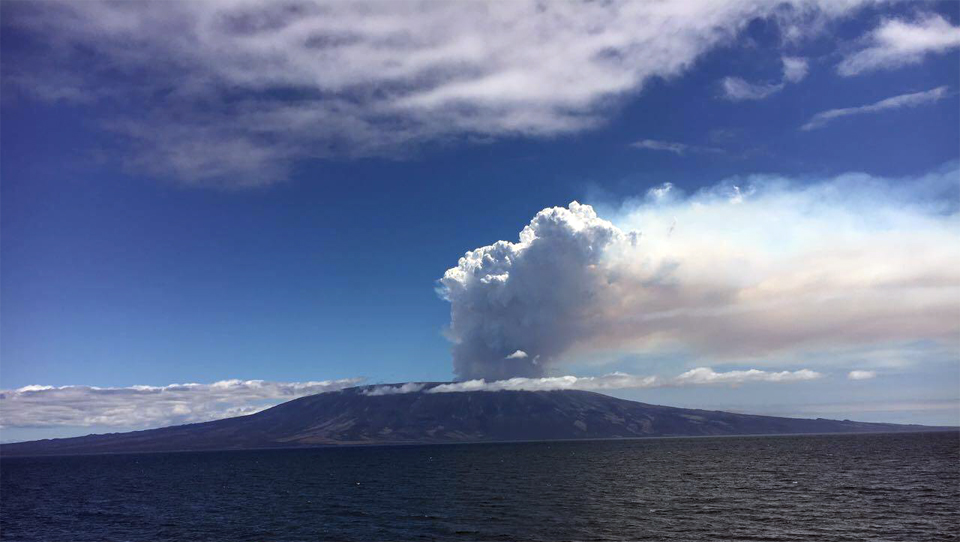 |
Figure 22. Fernandina began a new eruption on 4 September 2017. The initial plume was mostly steam, but contained significant SO2 and possibly minor ash. Photo by DPNG personnel, courtesy of IG-EPN (INFORME ESPECIAL VOLCÁN FERNANDINA N°1 – 2017, Lunes, 04 Septiembre 2017 16:49). |
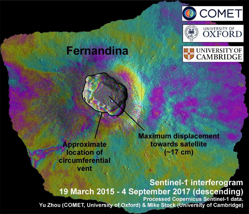 |
Figure 23. Interferogram image of Fernandina between 19 March 2015 and 4 September 2017 shows about 17 cm of inflation in the caldera. Each concentric band of colors within the caldera represents several centimeters of inflation. Created by Yu Zhou and Mike Stock, courtesy of IG-EPN (INFORME ESPECIAL DEL VOLCÁN FERNANDINA N°2 – 2017, Miércoles, 06 Septiembre 2017 17:16). |
Seismic activity began with hybrid-type earthquakes (fractures with fluid movements) followed by Long Period (LP) earthquakes (fluid movements). The seismic network of the Geophysical Institute installed in the Galapagos began to detect activity at the volcano around 0955 on 4 September 2017. The beginning of the eruption was associated with a volcanic tremor that began at 1225. At 1428, an eruptive column was visible in satellite imagery, interpreted at an approximate height of 4,000 m above the crater, drifting WNW (figure 24).
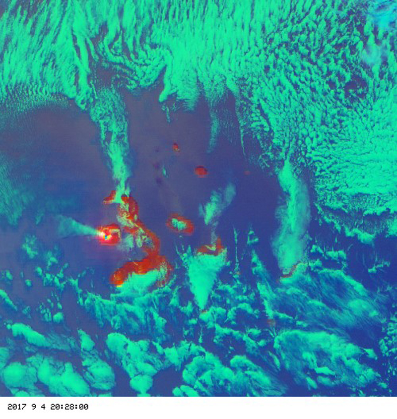 |
Figure 24. This false-color satellite image of Fernandina on 4 September 2017 showed the eruption column drifting NW estimated at 4,000 m altitude. Source: http://goes.higp.hawaii.edu/cgi-bin/imageview?sitename=galapagos. Courtesy of IG-EPN (INFORME ESPECIAL VOLCÁN FERNANDINA N°1 – 2017, Lunes, 04 Septiembre 2017 16:49). |
The Washington VAAC reported that satellite imagery indicated a lava eruption which produced a plume of steam and gas that rose to 2,400 m above sea level and extended about 60 km W of the summit. While initially no ash was reported in the plume, a few hours later a new VAAC report suggested that minor ash was possibly present, although it was most likely primarily SO2. Satellite data reported by the NASA Goddard Space Flight Center showed SO2 emissions on 4-6 and 8 September (figure 25).
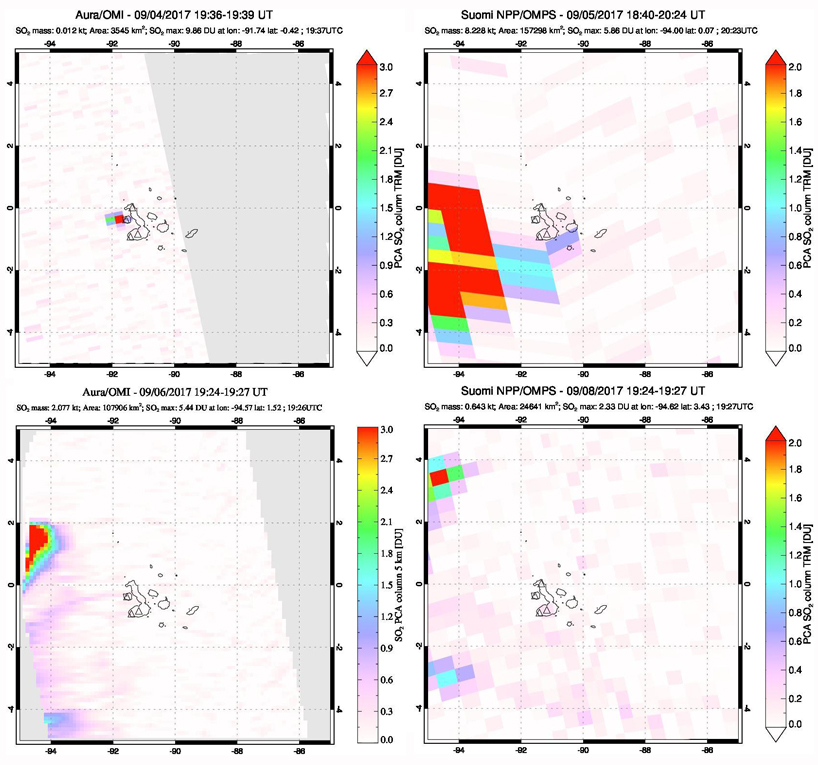 |
Figure 25. SO2 emissions from Fernandina were identified with the OMI instrument on the Aura satellite and the OMPS instrument on Japan's Suomi satellite during 4-8 September 2017. Upper left: A small SO2 emission emerges very close in time to the first reported observation of the eruption on 4 September. Upper right: The low-resolution OMPS image clearly shows a large plume drifting W about 24 hours later. Lower left and right: SO2 is present NW of the Galapagos over the eastern Pacific on 6 and 8 September. Courtesy of NASA Goddard Space Flight Center. |
Thermal alerts indicative of fresh lava flows from the rim of the summit crater were first reported by MODVOLC on 4 September 2017 (UTC), and abundant through 7 September (figure 26). No thermal anomalies were recorded in MODVOLC data on 8 September. An additional group of alert pixels was recorded on 9 September, but it's not clear if they were caused by fresh lava flows or burning fires; a few more intermittent pixels were recorded through 20 September. The MIROVA system also captured a significant spike in heatflow at Fernandina during the same period (figure 27). Some of the anomalies measured by both systems were likely the result of the fires caused by the lava flows as well as the flows themselves.
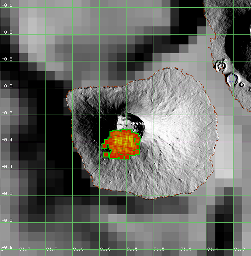 |
Figure 26. Map showing the location of new lava flows at Fernandina during 4-7 September 2017 using MODVOLC thermal alerts. Fires may have caused some of the alert pixels. Courtesy of HIGP MODVOLC Thermal Alerts System. |
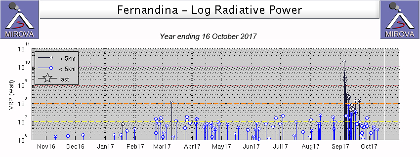 |
Figure 27. MIROVA thermal anomalies show a spike in activity at Fernandina during the period of the September 2017 eruption in this graph of log radiative power for the year ending on 16 October 2017. The initial spike that was located more than 5 km from the summit confirms the lava flows were located on the crater rim and flank and not in the summit crater. Some anomalies may also be due to the fires caused by the lava flows. Courtesy of MIROVA. |
Incandescence was first observed during the night of 4 September (figure 28). Lava flows apparently originated from a circumferential fissure near the fissure of the 2005 eruption on the SSW rim of the caldera. The lava flowed down the S and SW flanks but did not reach the sea. Active lava flows were observed during the night of 5 September (figure 29). The intensity of the eruption decreased significantly after about 48 hours.
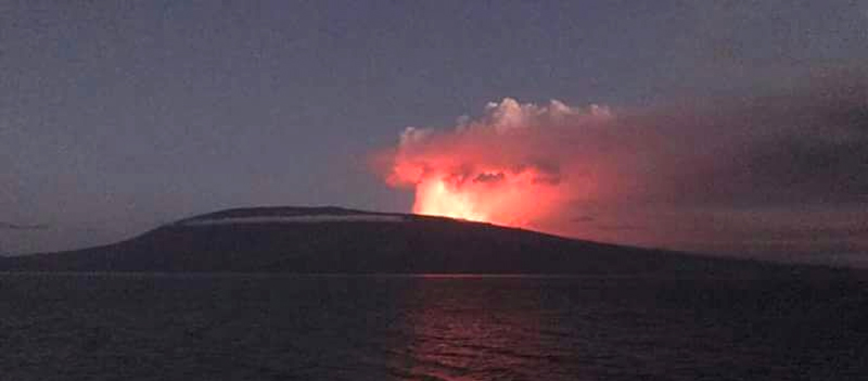 |
Figure 28. Incandescence at Fernandina on 4 September 2017. Photo by Alex Medina, courtesy of IG-EPN (INFORME ESPECIAL DEL VOLCÁN FERNANDINA N°2 – 2017, Miércoles, 06 Septiembre 2017 17:16). |
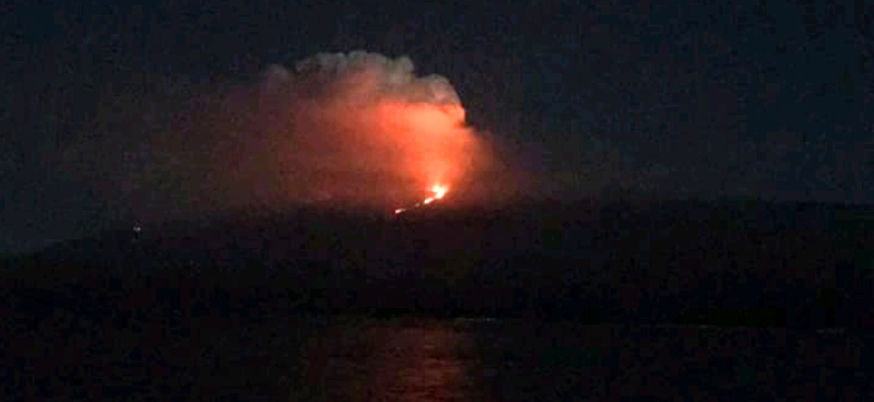 |
Figure 29. A lava flow is visible on the SW flank of Fernandina on 5 September 2017. Photo by Alex Medina, courtesy of IG-EPN (INFORME ESPECIAL DEL VOLCÁN FERNANDINA N°2 – 2017, Miércoles, 06 Septiembre 2017 17:16). |
A technical team from the Directorate of the Galapagos National Park (DPNG) made an aerial inspection using the seaplane Sea Wolf on 7 September 2017. They observed a radial fissure in the same area where the 2005 eruption occurred, and several lava flows. No recent volcanic activity or any landslides were seen inside the caldera. The lava flows had ceased movement, but there were isolated fires burning patches of vegetation surrounded by older lava flows (figures 30 and 31). The lava had traveled from the summit crater at about 1,200 m down to 500 m elevation. While lava was not observed flowing into the sea, coastal monitoring by the park rangers showed water vapor on the SW coast, so it was possible that lava had reached the ocean through subsurface lava tubes.
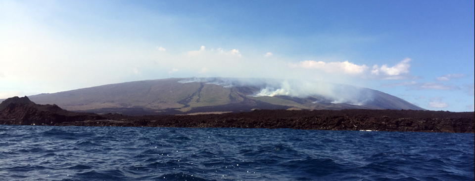 |
Figure 30. Lava flows burn vegetation on Fernandina during the eruption of September 2017. Observers on a 7 September 2017 flyover by DPNG reported that the active flows had ceased, but vegetation was burning at four different sites. Courtesy of Directorate of the Galapagos National Park (DPNG) (11/09/2017– Sobrevuelo al volcán La Cumbre, en Galápagos). |
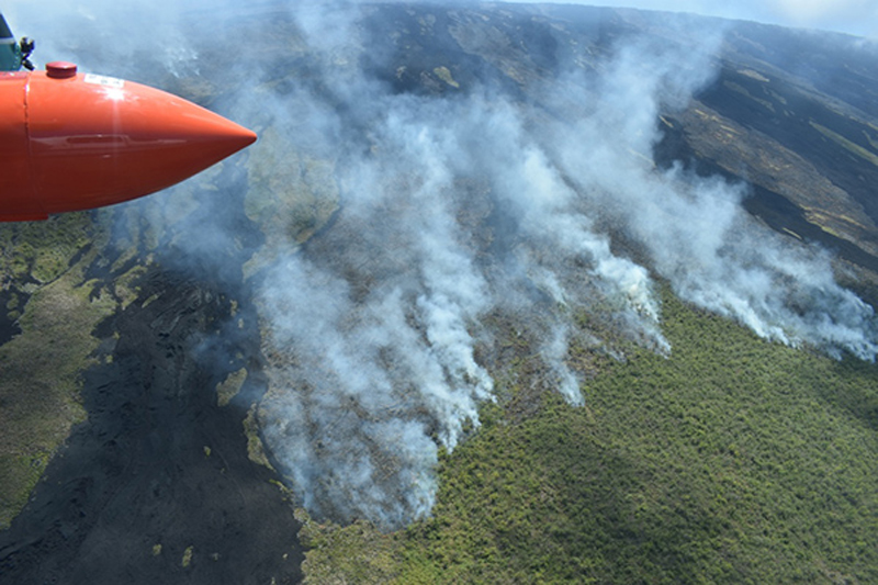 |
Figure 31. Vegetation on Fernandina burns on 7 September 2017 after lava flows erupted beginning on 4 September 2017. There was no evidence of flowing lava during the overflight. Courtesy of the Galapagos Conservancy. |
Geological Summary. Fernandina, the most active of Galápagos volcanoes and the one closest to the Galápagos mantle plume, is a basaltic shield volcano with a deep 5 x 6.5 km summit caldera. The volcano displays the classic "overturned soup bowl" profile of Galápagos shield volcanoes. Its caldera is elongated in a NW-SE direction and formed during several episodes of collapse. Circumferential fissures surround the caldera and were instrumental in growth of the volcano. Reporting has been poor in this uninhabited western end of the archipelago, and even a 1981 eruption was not witnessed at the time. In 1968 the caldera floor dropped 350 m following a major explosive eruption. Subsequent eruptions, mostly from vents located on or near the caldera boundary faults, have produced lava flows inside the caldera as well as those in 1995 that reached the coast from a SW-flank vent. Collapse of a nearly 1 km3 section of the east caldera wall during an eruption in 1988 produced a debris-avalanche deposit that covered much of the caldera floor and absorbed the caldera lake.
Information Contacts: Instituto Geofísico (IG-EPN), Escuela Politécnica Nacional, Casilla 17-01-2759, Quito, Ecuador (URL: http://www.igepn.edu.ec ); Dirección del Parque Nacional Galápagos (DPNG), Isla Santa Cruz, Galápagos, Ecuador (URL: http://www.galapagos.gob.ec/); MIROVA (Middle InfraRed Observation of Volcanic Activity), a collaborative project between the Universities of Turin and Florence (Italy) supported by the Centre for Volcanic Risk of the Italian Civil Protection Department (URL: http://www.mirovaweb.it/); Hawai'i Institute of Geophysics and Planetology (HIGP), MODVOLC Thermal Alerts System, School of Ocean and Earth Science and Technology (SOEST), Univ. of Hawai'i, 2525 Correa Road, Honolulu, HI 96822, USA (URL: http://modis.higp.hawaii.edu/); NASA Goddard Space Flight Center (NASA/GSFC), Global Sulfur Dioxide Monitoring Page, Atmospheric Chemistry and Dynamics Laboratory, 8800 Greenbelt Road, Goddard, Maryland, USA (URL: http://so2.gsfc.nasa.gov/index.html ); Galapagos Conservancy, (URL:https://www.galapagos.org).