Report on San Cristobal (Nicaragua) — March 2018

Bulletin of the Global Volcanism Network, vol. 43, no. 3 (March 2018)
Managing Editor: Edward Venzke.
Edited by A. Elizabeth Crafford.
San Cristobal (Nicaragua) Intermittent ash-bearing explosions during 2017; ash plume drifts 250 km in August
Please cite this report as:
Global Volcanism Program, 2018. Report on San Cristobal (Nicaragua) (Crafford, A.E., and Venzke, E., eds.). Bulletin of the Global Volcanism Network, 43:3. Smithsonian Institution. https://doi.org/10.5479/si.GVP.BGVN201803-344020
San Cristobal
Nicaragua
12.702°N, 87.004°W; summit elev. 1745 m
All times are local (unless otherwise noted)
Nicaragua's San Cristóbal volcanic complex has exhibited sporadic eruptive activity dated back to the early 16th century. More consistent modern record keeping has documented short-lived eruptive episodes every year since 1999. Small explosions with intermittent gas-and-ash emissions are typical. Three single-day explosive events were reported in 2015; a series of explosions on 5 March 2015 generated a 500 m high ash plume, 41 explosions on 6 June 2015 ejected ash 200 m above the summit, and the first of two explosions on 12 June 2015 sent an ash plume 2,000 m above the summit. The next eruption did not occur until 22 April 2016 when 11 explosions were recorded, with the largest sending an ash plume 2,000 m above the summit. Activity from July 2016-December 2017 is covered in this report. Information is provided by the Instituto Nicaragüense de Estudios Territoriales (INETER), and the Washington Volcanic Ash Advisory Center (VAAC).
Following little activity during the remainder of 2016 after the 22 April explosions, small explosions with minor ash were reported in February, March, and April 2017. Significant explosions during 18-19 August sent ash plumes over 200 km W and deposited ash in numerous communities. Seismicity was high during October-December 2017, but ash-bearing explosions were only reported on 7 and 11 November.
After the 22 April 2016 explosions, San Cristóbal remained quiet for the remainder of 2016. In the month's they were measured, 45-72 degassing-type seismic events were recorded. During a field visit on 29 November 2016, new landslides around the crater rim, both inside the crater and down the outer flanks, were observed. These were interpreted by INETER scientists as resulting from a major tectonic earthquake that occurred offshore in mid-November that was felt in nearby Chinandega (16 km SW), and not from volcanic activity.
Seismic activity increased slightly in January 2017 with 100 degassing events recorded. INETER reported 15 small ash-and-gas explosions during 18-19 February and 153 degassing events. There were no reports of ashfall in the nearby communities. Only 27 degassing seismic events were reported in March; three small gas explosions with minor ash occurred on 16, 25, and 28 March 2017.
Eight small explosions with gas and minor ash took place during April 2017 on days 13, 15, 16 and 19, but no damage was reported in nearby communities. Very low values of SO2 (averaging 147 tons/day) were measured at the end of April 2017, far less than values of 854 and 642 measured in September and October 2016. Degassing-type seismic events increased sharply beginning on 20 April, totaling 1,931 events; they remained elevated through 25 April.
Volcano-tectonic (VT) earthquakes increased significantly to 235 recorded events during May, from values in the single digits earlier in the year. Minor fumarolic activity occurred at the S side of the summit crater on 27 May 2017 (figure 33). Two small gas explosions were recorded on 20 and 27 May, but no ash emissions were reported. A significant increase to 2,349 degasification-type earthquakes was reported during June 2017; slightly fewer (1,981) were reported during July.
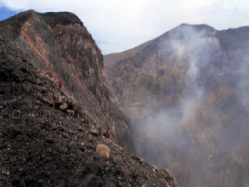 |
Figure 33. Minor fumarolic activity was observed at the S side of the summit crater at San Cristóbal during a field visit by INETER on 27 May 2017. Courtesy of INETER (Boletín mensual, Sismos y Volcanes de Nicaragua, Mayo 2017). |
Significant explosions early on 18 August 2017 were observed from Chinandega with notable gas and ash emissions (figure 34), and ashfall was deposited around the region (figure 35). Communities affected by the ashfall were located to the W and SW of the volcano and included Belén, La Mora, La Bolsa, El Viejo (18 km WSW), La Grecia, Realejo (25 km SW) and Corinto (30 km SW). Ash plumes rose between 300 and 600 m above the crater rim and drifted W and SW. Additional explosions occurred the next day but had ceased by 20 August.
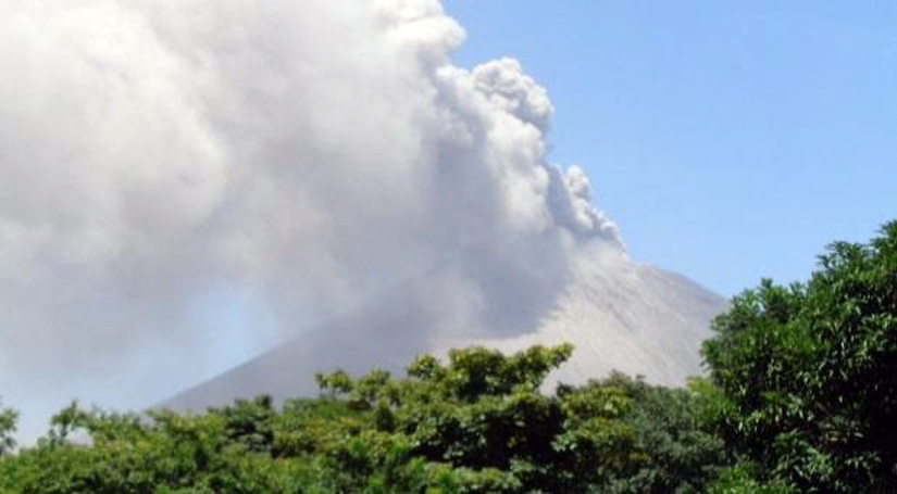 |
Figure 34. Explosion and ash plume at San Cristóbal at 1330 on 18 August 2017. Courtesy of INETER (Boletín mensual, Sismos y Volcanes de Nicaragua, Agosto, 2017). |
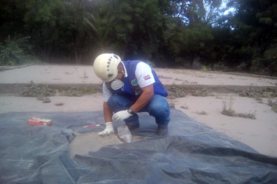 |
Figure 35. Ash was collected by INETER scientists from the 18 August 2017 explosion at San Cristóbal. Courtesy of INETER (Boletín mensual, Sismos y Volcanes de Nicaragua, Agosto, 2017). |
A small plume was noted in satellite imagery by the Washington VAAC on 18 August 2017 moving NW. Later imagery showed gas and ash drifting W at an estimated altitude of 2.1 km. It extended approximately 265 km W of the summit before dissipating. Ground measurements of SO2 made during 18-20 August showed increases to a peak of 3,519 metric tons per day on 19 August before dropping back to more typical background values below 700 t/d. INETER scientists used GOES and AVHRR satellite images to identify the maximum extent of the ash plume from the eruptive event. The ash cloud covered the area W of San Cristóbal, approximately 2,960 Km2, and extended more than 80 km offshore, with a total length of 125 km and a maximum width of 33 km (figure 36). Seismometers recorded 3,880 degassing-type seismic events during August 2017. Seismicity decreased slightly during September 2017 to 2,604 measured events, of which 2,415 were degassing-type, 187 were VT events, and two explosions were recorded on 1 September, but no ashfall was reported.
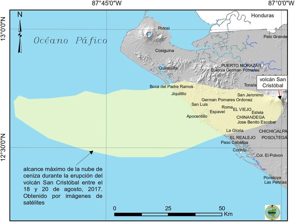 |
Figure 36. The extent of the ash plume from the 18-20 August 2017 eruptive episode at San Cristóbal, identified in satellite imagery by INETER scientists. Courtesy of INETER (Boletín mensual, Sismos y Volcanes de Nicaragua, Agosto, 2017). |
An order-of-magnitude increase in seismicity occurred during October-December 2017, with the monthly totals of the numbers of events ranging from 17,000-21,000 (figure 37). INETER reported a series of 14 explosions during the evening of 7 November. Ashfall was reported to the W in Los Farallones, San Agustín, La Mora, El Naranjo and the city of Chinandega. The Washington VAAC subsequently reported an ash plume that models suggested rose to 6.7 km and drifted W on 11 November.
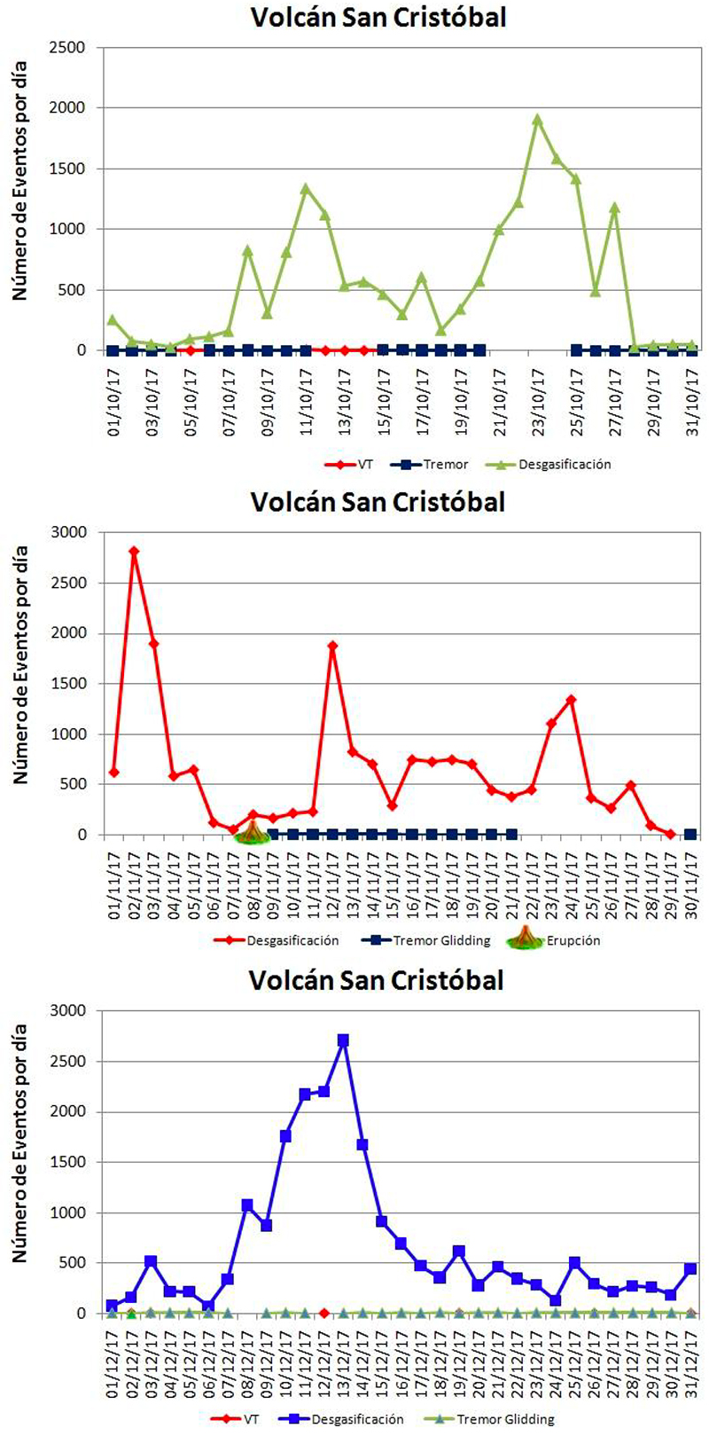 |
Figure 37. Numbers of daily seismic events at San Cristóbal during October-December 2017. Event types include VT (volcano-tectonic), degasification, and tremor. Note scale in each graph as different symbols and colors are used for the same type each month. Total seismic events for October (top) was 17,815, November (middle) was 19,206, and December (bottom) was 20,925. Ash bearing explosions were reported by INETER on 7 November, and the Washington VAAC reported an ash plume on 11 November that possibly rose to 6.7 km altitude and drifted W. Courtesy of INETER (Boletín mensual, Sismos y Volcanes de Nicaragua, Octubre, Noviembre, Diciembre, 2017). |
Geological Summary. The San Cristóbal volcanic complex, consisting of five principal volcanic edifices, forms the NW end of the Marrabios Range. The symmetrical 1745-m-high youngest cone, named San Cristóbal (also known as El Viejo), is Nicaragua's highest volcano and is capped by a 500 x 600 m wide crater. El Chonco, with several flank lava domes, is located 4 km W of San Cristóbal; it and the eroded Moyotepe volcano, 4 km NE of San Cristóbal, are of Pleistocene age. Volcán Casita, containing an elongated summit crater, lies immediately east of San Cristóbal and was the site of a catastrophic landslide and lahar in 1998. The Plio-Pleistocene La Pelona caldera is located at the eastern end of the complex. Historical eruptions from San Cristóbal, consisting of small-to-moderate explosive activity, have been reported since the 16th century. Some other 16th-century eruptions attributed to Casita volcano are uncertain and may pertain to other Marrabios Range volcanoes.
Information Contacts: Instituto Nicaragüense de Estudios Territoriales (INETER), Apartado Postal 2110, Managua, Nicaragua (URL: http://www.ineter.gob.ni/); Washington Volcanic Ash Advisory Center (VAAC), Satellite Analysis Branch (SAB), NOAA/NESDIS OSPO, NOAA Science Center Room 401, 5200 Auth Rd, Camp Springs, MD 20746, USA (URL: www.ospo.noaa.gov/Products/atmosphere/vaac, archive at: http://www.ssd.noaa.gov/VAAC/archive.html).