Report on Kusatsu-Shiranesan (Japan) — April 2018
Bulletin of the Global Volcanism Network, vol. 43, no. 4 (April 2018)
Managing Editor: Edward Venzke.
Edited by A. Elizabeth Crafford.
Kusatsu-Shiranesan (Japan) Phreatic explosion at Motoshiranesan cone on 23 January 2018 results in one fatality and several injuries
Please cite this report as:
Global Volcanism Program, 2018. Report on Kusatsu-Shiranesan (Japan) (Crafford, A.E., and Venzke, E., eds.). Bulletin of the Global Volcanism Network, 43:4. Smithsonian Institution. https://doi.org/10.5479/si.GVP.BGVN201804-283120
Kusatsu-Shiranesan
Japan
36.618°N, 138.528°E; summit elev. 2165 m
All times are local (unless otherwise noted)
The large Kusatsu-Shiranesan volcanic complex comprises three overlapping pyroclastic cones and numerous summit craters; it is located about 150 km NW of Tokyo in the Gunma Prefecture of central Japan. Intermittent short-lived historic activity has been reported from the northernmost Shiranesan cone since the beginning of the 19th century. An explosion at the southernmost Motoshiranesan cone in January 2018 resulted in one fatality and several injuries. Information about the event was gathered from the Japan Meteorological Agency (JMA) and various news sources.
Summary of activity during 1976-2014. Small phreatic explosions in the Mizugama and Yugama craters at the northernmost part of the Kusatsu-Shiranesan volcanic complex occurred in 1976, 1982, and 1983 (figure 14). Larger ash-bearing explosions in November and December 1983 sent tephra 30-40 km to communities downwind to the SE from the Yugama and adjacent Karagama craters on the Shiranesan cone. Intermittent increases in seismic activity near the Yugama crater coincided with water discoloration in the crater lake, and possible ejections of debris from hydrothermal activity in 1989 and 1996. Increased hydrothermal activity was noted on the N flank of Yugama during 2013-2014. Seismic swarms, deformation, thermal, and fumarolic activity increased briefly during early June 2014 in the area around the Yugama crater lake, but no eruption was observed. In late June 2014, JMA reported dying vegetation in a forested area 3 km SW of the Motoshiranesan summit area.
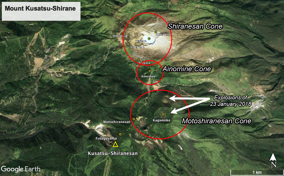 |
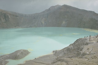
Figure 14. Subfeatures of the Kusatsu-Shiranesan volcanic complex as seen in Google Earth imagery, looking N. The northernmost bleached area includes the historically active Yugama, Mizugama, and Karagama craters, part of the Shiranesan cone. In the center of the complex is the Ainomine cone which has a ski area on the S flank. The southernmost edifice is the Motoshiranesan cone which has multiple craters at its summit, including Kagamiike or "Mirror pond". The explosions of 23 January 2018 occurred at Kagamiike and the adjacent crater to the N, in area referred to by JMA as Honkonoyama. Courtesy of Google Earth. |
Activity during 2014-2017. Seismicity remained elevated from March to mid-August 2014 around the Yugama crater area. Ground deformation data suggested inflation between March 2014 and April 2015 in that area. Field surveys conducted on 4-5 and 10-11 November 2014 indicated fumarolic areas on the N and NE flanks of the Mizugama crater, but no other significant activity. Short-lived increases in seismicity were observed during January-February 2015. A field survey in May 2015 confirmed ongoing thermal activity on the N and NE wall of the Yugama crater, and the N and NE flank of the Mizugama crater. A small-amplitude, 2-minute-long tremor during late June 2015 was the first since January 2013; it was not accompanied by eruptive activity. The fumarolic activity on the N wall of the Yugama Crater was higher during a field survey in October 2015 than in had been the previous May.
Thermal activity was ongoing at Yugama and Mizugama craters during 2015-2017 along with intermittent fumarolic activity in the same general area, but no significant seismicity was reported. By June 2017 the decrease in the concentration of components derived from high-temperature volcanic gas in the lake, and the stable low-level seismicity in the area, led JMA to lower the warning level from 2 to 1 (on a 5 level scale) on 7 June 2017; they noted that the thermal activity continued around the Yugama crater throughout the rest of the year (figures 15-17).
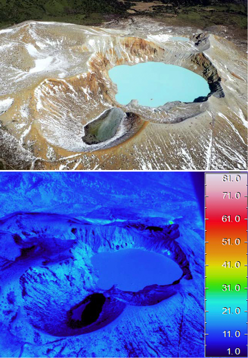 |
Figure 15. A minor thermal anomaly persisted inside the NE crater wall at Yagama Crater at Kusatsu-Shiranesan throughout 2015-2017. Both visual (upper) and thermal (lower) images were taken during an overflight on 1 November 2017. View is to the north. Courtesy of JMA (Volcanic activity monthly report, Kusatsu-Shirane, November 2017). |
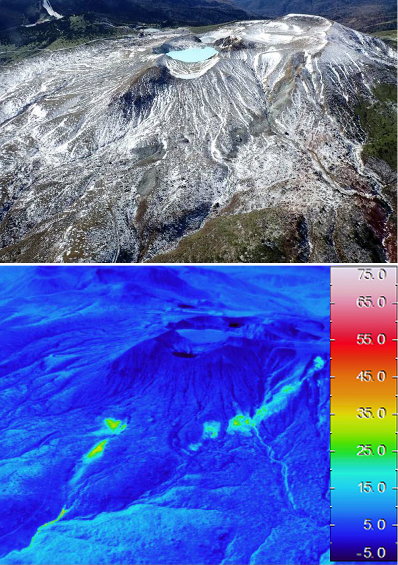 |
Figure 16. Thermal anomalies persisted on the N and NE flank of the Mizugama crater at Kusatsu-Shiranesan during 2015-2017. These visual (upper) and thermal (lower) images were captured on 1 November 2017. Courtesy of JMA (Volcanic activity monthly report, Kusatsu-Shirane, November 2017). |
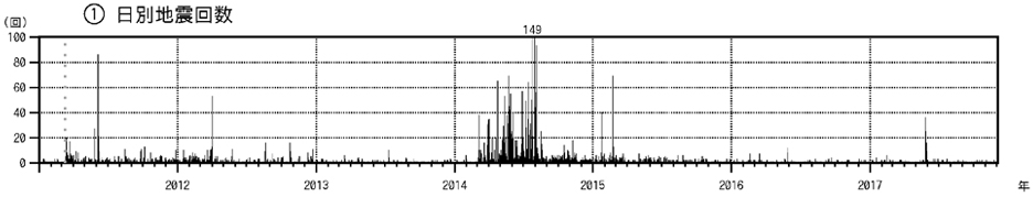 |
Figure 17. Daily earthquake frequency at Kusatsu-Shiranesan during 1 January 2011-30 November 2017. Although earthquake counts temporarily increased during March-August 2014 and in January and February 2015, no eruptive activity was reported. Courtesy of JMA (Volcanic activity monthly report, Kusatsu-Shirane, November 2017). |
Activity during January-March 2018. JMA reported that at 0959 on 23 January 2018 an eruption began at Kusatsu-Shiranesan coincident with the onset of volcanic tremor which prompted JMA to raise the Alert Level to 3 (on a scale of 1-5); there had been no prior indications of an impending eruption. Skiers at the popular Kusatsu Kokusai ski resort, located on the Ainomine cone, took video showing a plume of tephra and ejected bombs rising from vents around the Kagamiiki and adjacent crater at the summit of the Motoshiranesan cone (see Information Contacts for Mainichi for video link). Motoshiranesan is immediately adjacent S of the Ainomine cone and about 2 km SSE of the Yagama Crater on the Shiranesan cone where all previous historical activity had been reported (figures 14 and 18).
 |
Figure 18. Locations and images of the active vents at Kusatsu-Shiranesan during the eruptive event of 23 January 2018. Upper left: View is looking W at the Motoshiranesan summit craters. The crater with the pond in Box 1 is Kagamiike (yellow Japanese characters). Boxes 1 and 2 in the upper left photo are enlarged in the lower photos. Upper right topographic map shows the locations in red of the three vents. The upper red line and dot correspond to the vents shown in the lower right box 2. The lower red bar on the topographic map (near the small pond) corresponds to the vent shown in the lower left image as box 1. Courtesy of JMA (Volcanic activity monthly report, Kusatsu-Shirane, January 2018). |
Photos and video posted in news articles showed tephra shooting tens of meters into the air, drifting E, and blanketing the nearby hillside (figure 19); JMA noted ashfall in Nakanojo-machi, in the Gunma Prefecture, about 8 km E. Tephra hit a gondola, shattering glass and injuring four skiers (figure 20). Material fell through the roof of a lodge, where about 100 people had already been evacuated. Ground Self-Defense Force troops were engaging in ski training at the time of the event; one member died from the impact of large tephra blocks, and seven others were injured.
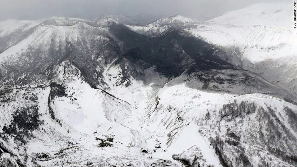 |
Figure 19. Tephra from Mount Kusatsu-Shiranesan covers the N flank of the Motoshiranesan cone and much of the Ainomine cone in this view to the W taken on 23 January 2018. Photo by Suo Takeuma, AP, courtesy of CNN (Japanese man killed by falling rocks after volcano erupts at ski resort, 23 January 2018). |
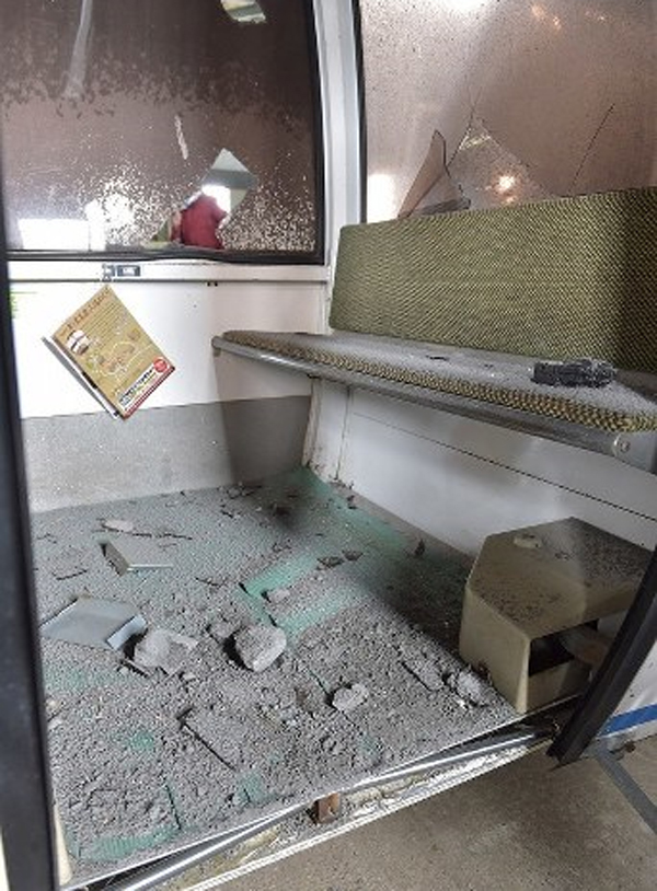 |
Figure 20. Fist-sized tephra blocks and ash ejected from the eruption of Mount Kusatsu-Shiranesan cover the floor of a damaged gondola at the Kusatsu Kokusai Ski Resort on 24 January 2018, courtesy of The Mainichi Japan (Damaged ski resort gondolas show the power of Gunma Pref. volcanic eruption, 25 January 2018). |
The following day, on 24 January 2018, JMA noted that volcanic earthquakes were numerous but decreasing in number, and two 2-3-minute-long periods of volcanic tremor were detected at 1015 and 1049. Minor but elevated seismicity continued through 30 January, punctuated by periods of tremor. The largest fissure where the eruption occurred was oriented E-W, located just inside the N rim of the northernmost crater at the Motoshiranesan summit (figure 21). Kenji Nogami, a professor at the Tokyo Institute of Technology, confirmed that the event appeared to have been "a typical phreatic eruption" (Japan Times).
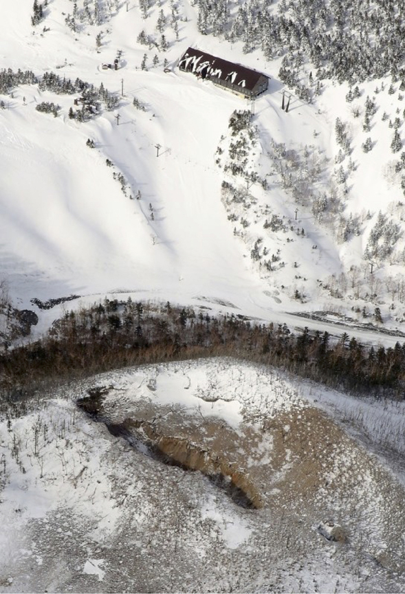 |
Figure 21. The largest fissure vent active in the 23 January 2018 explosion at Kusatsu-Shiranesan was still surrounded by ash and tephra when photographed during an overflight on 28 January 2018. The summit ropeway station of the ski area is at the image top just NW of the explosion vent. Courtesy of The Mainichi (Visitor traffic plunges in Kusatsu hot spring resort after deadly eruptions, 30 January 2018). |
The Tokyo Volcanic Ash Advisory Center issued a single volcanic ash advisory on 23 January indicating a possible eruption, but it was not identifiable from satellite data. Observations made on 14 February 2018 confirmed the presence of the vents in the Kagamiike and adjacent crater, but there was no evidence of thermal activity and little fumarolic activity in the area (figure 22). Seismicity decreased steadily after the explosion on 23 January 2018 through the end of March 2018 and no further activity was reported (figure 23).
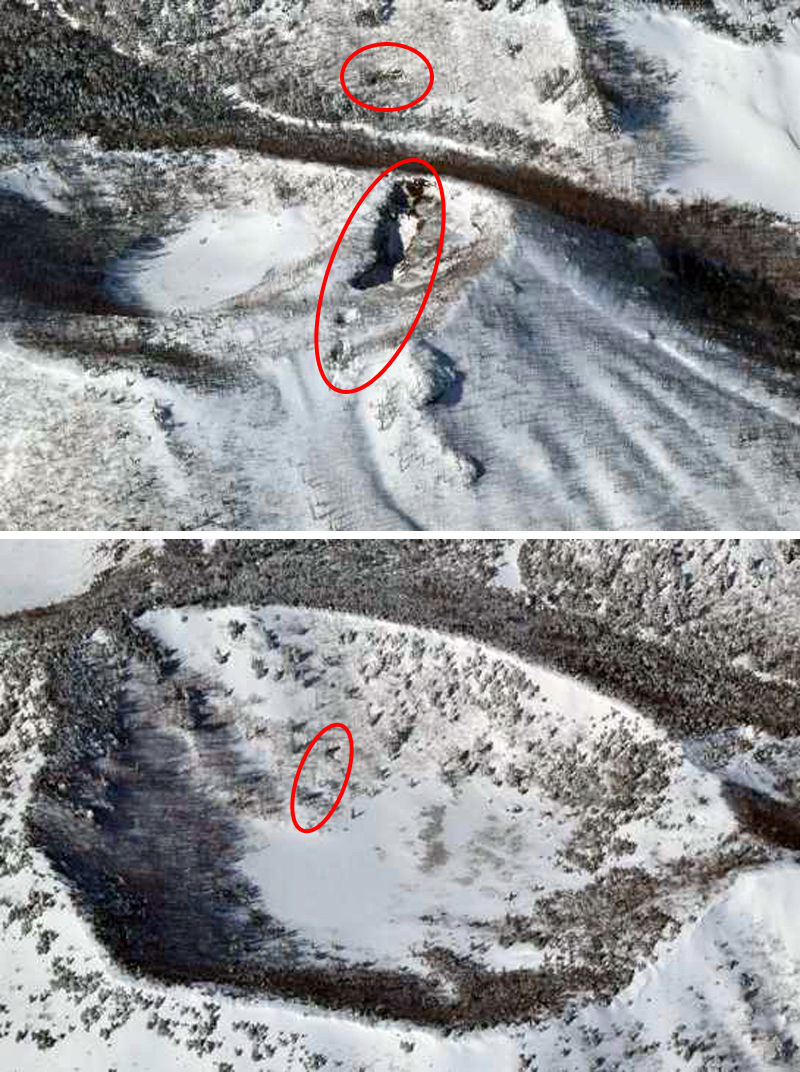 |
Figure 22. Vents from the 23 January 2018 eruption at Kusatsu-Shiranesan were still visible at the craters on 14 February 2014 during a helicopter overflight by JMA. The upper image, looking W, shows the large vent at the N side of the crater immediately N of the Kagamiike crater, as well as a smaller vent located to the W on the E flank of the adjacent slope. The lower image shows two smaller vents on the inner wall of the adjacent Kagamiike crater. Courtesy of JMA (Volcanic activity monthly report, Kusatsu-Shirane, February 2018). |
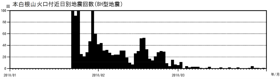 |
Figure 23. Seismicity decreased steadily at Kusatsu-Shiranesan after the explosion on 23 January 2018. Graph shows the number of daily seismic events during 1 January-31 March 2018. Courtesy of JMA (Volcanic activity monthly report, Kusatsu-Shirane, March 2018). |
Geological Summary. The Kusatsu-Shiranesan complex, located immediately north of Asama volcano, consists of a series of overlapping pyroclastic cones and three crater lakes. The andesitic-to-dacitic volcano was formed in three eruptive stages beginning in the early to mid-Pleistocene. The Pleistocene Oshi pyroclastic flow produced extensive welded tuffs and non-welded pumice that covers much of the E, S, and SW flanks. The latest eruptive stage began about 14,000 years ago. Historical eruptions have consisted of phreatic explosions from the acidic crater lakes or their margins. Fumaroles and hot springs that dot the flanks have strongly acidified many rivers draining from the volcano. The crater was the site of active sulfur mining for many years during the 19th and 20th centuries.
Information Contacts: Japan Meteorological Agency (JMA), Otemachi, 1-3-4, Chiyoda-ku Tokyo 100-8122, Japan (URL: http://www.jma.go.jp/jma/indexe.html); The Mainichi (URL: http://mainichi.jp/english/, eruption video URL-https://mainichi.jp/movie/video/?id=121708141#cxrecs_s); The Japan Times (URL: https://www.japantimes.co.jp/); Cable News Network (CNN), Turner Broadcasting System, Inc. (URL: http://www.cnn.com/).