Report on Bagana (Papua New Guinea) — May 2018

Bulletin of the Global Volcanism Network, vol. 43, no. 5 (May 2018)
Managing Editor: Edward Venzke.
Research and preparation by Paul Berger.
Bagana (Papua New Guinea) Intermittent ash plumes and thermal anomalies continue through 15 April 2018
Please cite this report as:
Global Volcanism Program, 2018. Report on Bagana (Papua New Guinea) (Venzke, E., ed.). Bulletin of the Global Volcanism Network, 43:5. Smithsonian Institution. https://doi.org/10.5479/si.GVP.BGVN201805-255020
Bagana
Papua New Guinea
6.137°S, 155.196°E; summit elev. 1855 m
All times are local (unless otherwise noted)
Bagana is a relatively remote volcano on Bougainville Island that is poorly monitored except by satellite. The most recent eruptive phase began on or before early 2000 with intermittent ash plumes and thermal anomalies (BGVN 41:04, 41:07, 42:08). During the period 13 June 2017-15 April 2018, this same pattern of activity continued. Intermittent ash plumes rose to 2.1-2.4 km altitude (table 6). Plume activity was especially elevated during August 2017. Satellite data indicate that both plume activity and thermal alerts had decreased markedly by the beginning of March 2018.
Table 6. Summary of ash plumes from Bagana reported during 14 June 2017-15 April 2018. Courtesy of the Darwin Volcanic Ash Advisory Centre (VAAC).
| Date | Max Plume Altitude (km) | Plume Drift |
| 14 Jun 2017 | 2.1 | 65 km SW, W, NW |
| 22, 25 Jun 2017 | 2.1 | NW |
| 02 Jul 2017 | 2.1 | W |
| 16 Jul 2017 | 2.1 | W |
| 23 Jul 2017 | 2.1 | W |
| 01 Aug 2017 | 2.1 | W |
| 05-08 Aug 2017 | 2.1 | Multiple |
| 09-10, 13 Aug 2017 | 2.4 | W, NW (120 km W on 13 Aug) |
| 24-28 Aug 2017 | 2.1-2.4 | WNW, W, SW |
| 31 Aug 2017 | 2.1 | N, W, SW |
| 11-12 Sep 2017 | 2.1 | NW |
| 27 Oct 2017 | 2.1 | E, NE |
| 03 Nov 2017 | 2.4 | NE |
| 15-17 Nov 2017 | 2.1 | N, SW, SSW, W |
| 25-26 Dec 2017 | 2.4 | NE |
| 07-08 Feb 2018 | 2.4 | NE |
| 26-27 Feb 2018 | 2.1 | WNW |
| 02 Mar 2018 | 2.4 | NE |
| 14-15 Apr 2018 | 2.1-2.4 | 110 km SW |
Thermal anomalies, based on MODIS satellite instruments analyzed using the MODVOLC algorithm, were observed 0-3 days each month during June-November 2017, seven days in December 2017, one day in January 2018, and two days in February 2018. More than two pixels were recorded on 4-5 and 9 December (up to five pixels), 31 January (4 pixels), and 4 February (5 pixels).
The MIROVA (Middle InfraRed Observation of Volcanic Activity) volcano hotspot detection system, also based on analysis of MODIS data, recorded a moderate number of thermal alerts within 5 km of the volcano from June through late November 2017, except for a decrease between mid-September and mid-October (figure 21). Activity rose sharply during the end of November through early December and again during the first half of January before tapering off, a pattern inconsistent with the reported ash plumes. Few hotspots were detected between mid-February through 15 April, a pattern consistent with the MODVOLC data.
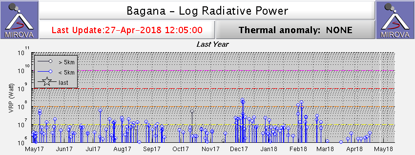 |
Figure 21. Thermal anomalies at Bagana shown on a MIROVA plot (Log Radiative Power) for the year ending 27 April 2018. Courtesy of MIROVA. |
Sulfur dioxide anomalies since June 2016 above 2.5 Dobson Units (Ozone Monitoring Instrument, OMI) or above 1.6 Dobson Units (Ozone Mapping and Profiler Suite, OMPS) occurred in 2016 on 4 and 6 July, 10-11 October, 11 November, and 3 December. Similar emissions were detected in 2017 on 30 January, 3 and 19 March, 15 April, 5 August, and 2 and 7 December. The satellite data showed high levels of SO2 in 2018 on 8 and 24 February, and 29 March.
Geological Summary. Bagana volcano, in a remote portion of central Bougainville Island, is frequently active. This massive symmetrical cone was largely constructed by an accumulation of viscous andesitic lava flows. The entire edifice could have been constructed in about 300 years at its present rate of lava production. Eruptive activity is characterized by non-explosive effusion of viscous lava that maintains a small lava dome in the summit crater, although occasional explosive activity produces pyroclastic flows. Lava flows with tongue-shaped lobes up to 50 m thick and prominent levees descend the flanks on all sides.
Information Contacts: Darwin Volcanic Ash Advisory Centre (VAAC), Bureau of Meteorology, Northern Territory Regional Office, PO Box 40050, Casuarina, NT 0811, Australia (URL: http://www.bom.gov.au/info/vaac/); MIROVA, a collaborative project between the Universities of Turin and Florence (Italy) supported by the Centre for Volcanic Risk of the Italian Civil Protection Department (URL: http://www.mirovaweb.it/); Hawai'i Institute of Geophysics and Planetology (HIGP) - MODVOLC Thermal Alerts System, School of Ocean and Earth Science and Technology (SOEST), Univ. of Hawai'i, 2525 Correa Road, Honolulu, HI 96822, USA (URL: http://modis.higp.hawaii.edu/); NASA Goddard Space Flight Center (NASA/GSFC), Global Sulfur Dioxide Monitoring Page, Atmospheric Chemistry and Dynamics Laboratory, 8800 Greenbelt Road, Goddard, Maryland, USA (URL: https://so2.gsfc.nasa.gov/).