Report on Ibu (Indonesia) — May 2018

Bulletin of the Global Volcanism Network, vol. 43, no. 5 (May 2018)
Managing Editor: Edward Venzke.
Research and preparation by Robert Andrews.
Ibu (Indonesia) Ongoing thermal anomalies from dome growth in the summit crater through April 2018
Please cite this report as:
Global Volcanism Program, 2018. Report on Ibu (Indonesia) (Venzke, E., ed.). Bulletin of the Global Volcanism Network, 43:5. Smithsonian Institution. https://doi.org/10.5479/si.GVP.BGVN201805-268030
Ibu
Indonesia
1.488°N, 127.63°E; summit elev. 1325 m
All times are local (unless otherwise noted)
Ongoing activity at Ibu volcano from April through August 2017 consisted primarily of intermittent ash explosions (BGVN 42:10). Based on data and reports through April 2018, the eruption that began on 5 April 2008 appeared to be continuing. Monitoring of the volcano is the responsibility of the Pusat Vulkanologi dan Mitigasi Bencana Geologi (PVMBG), also known as the Center for Volcanology and Geological Hazard Mitigation (CVGHM). Additional data below come from the Darwin Volcanic Ash Advisory Centre (VAAC) notices, with infrared MODIS data analyzed by the MODVOLC and MIROVA systems.
There were no reports of ash plumes from September 2017 through early March 2018. Although the summit area is often covered in fog, on 7-8 March ash plumes were observed rising 300-600 m above the crater rim and drifting W and S (table 3). Additional eruption plumes with ash were reported on 20 and 30 April. The Alert Level remained at 2 (on a scale of 1-4) and the public was warned to stay at least 2-3.5 km away from the active crater.
Table 3. Monthly summary of reported ash plumes and MODIS thermal anomalies from Ibu for August 2017-April 2018. The direction of drift for the ash plume through each month is highly variable. Data from Darwin VAAC, PVMBG, and MODVOLC.
| Month | Plume Altitude (km) | Plume Drift | Days with MODVOLC Alert Pixels |
| Sep 2017 | -- | -- | 4 |
| Oct 2017 | -- | -- | 5 |
| Nov 2017 | -- | -- | 4 |
| Dec 2017 | -- | -- | 4 |
| Jan 2018 | -- | -- | 4 |
| Feb 2018 | -- | -- | 2 |
| Mar 2018 | 1.6-1.9 | W, S | 2 |
| Apr 2018 | 1.8-1.9 | E, S | 3 |
Thermal anomalies identified by the MIROVA system using MODIS satellite data (figure 12) show that activity has been ongoing and almost continuous during May 2017-April 2018. Anomalies for the same time period detected and mapped using MODVOLC (figure 13, table 3) appear to be centered towards the north part of the crater and possibly extending down the N flank. This may indicate eruptive activity similar to that reported by PVMBG in June-December 2013 (BGVN 38:11) where the lava dome grew above the crater rim and sent incandescent material over a low notch in the rim and down a river valley towards Duono village, about 5 km NW.
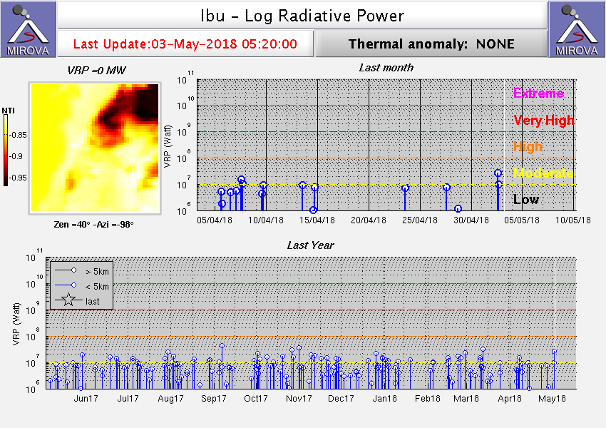 |
Figure 12. Thermal anomalies at Ibu shown on a MIROVA plot (Log Radiative Power) for the year ending 3 May 2018. Courtesy of MIROVA. |
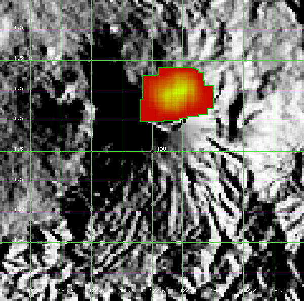 |
Figure 13. A contour map showing MODVOLC thermal alert pixels at Ibu for the year ending 3 May 2018. Pixels are centered at the north crater rim and down the N flank. Courtesy of Hawai'i Institute of Geophysics and Planetology (HIGP) - MODVOLC Thermal Alerts System. |
Geological Summary. The truncated summit of Gunung Ibu stratovolcano along the NW coast of Halmahera Island has large nested summit craters. The inner crater, 1 km wide and 400 m deep, has contained several small crater lakes. The 1.2-km-wide outer crater is breached on the N, creating a steep-walled valley. A large cone grew ENE of the summit, and a smaller one to the WSW has fed a lava flow down the W flank. A group of maars is located below the N and W flanks. The first observed and recorded eruption was a small explosion from the summit crater in 1911. Eruptive activity began again in December 1998, producing a lava dome that eventually covered much of the floor of the inner summit crater along with ongoing explosive ash emissions.
Information Contacts: Pusat Vulkanologi dan Mitigasi Bencana Geologi (PVMBG, also known as Indonesian Center for Volcanology and Geological Hazard Mitigation, CVGHM), Jalan Diponegoro 57, Bandung 40122, Indonesia (URL: http://www.vsi.esdm.go.id/); Darwin Volcanic Ash Advisory Centre (VAAC), Bureau of Meteorology, Northern Territory Regional Office, PO Box 40050, Casuarina, NT 0811, Australia (URL: http://www.bom.gov.au/info/vaac/); Hawai'i Institute of Geophysics and Planetology (HIGP) - MODVOLC Thermal Alerts System, School of Ocean and Earth Science and Technology (SOEST), Univ. of Hawai'i, 2525 Correa Road, Honolulu, HI 96822, USA (URL: http://modis.higp.hawaii.edu/); MIROVA (Middle InfraRed Observation of Volcanic Activity), a collaborative project between the Universities of Turin and Florence (Italy) supported by the Centre for Volcanic Risk of the Italian Civil Protection Department (URL: http://www.mirovaweb.it/).