Ambae
Vanuatu
15.389°S, 167.835°E; summit elev. 1496 m
All times are local (unless otherwise noted)
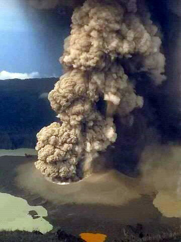
Ambae (Aoba) is a large basaltic shield volcano in the New Hebrides arc that has generated periodic phreatic and pyroclastic explosions originating in the summit crater lakes Manaro Lakua and Voui during the last 25 years; the central edifice with the active summit craters is often referred to as Manaro Voui. A pyroclastic cone appeared in Lake Voui during November 2005-February 2006 (figure 30, BGVN 31:12). The volcano remained mostly quiet until an explosive eruption from a new pyroclastic cone in the lake began in mid-September 2017 and lasted through mid-November (BGVN 43:02). Activity included high-altitude ash emissions (9.1 km), lava flows, and Strombolian activity. After a quieter December, ash emissions resumed during January-April 2018. This report summarizes activity from January to June 2018, with information provided by the Vanuatu Geohazards Observatory of the Vanuatu Meteorology and Geo-Hazards Department (VMGD), the Wellington Volcanic Ash Advisory Center (VAAC), satellite data from several sources, and social media photographs.
Ongoing steam and intermittent ash emissions were observed during January and February 2018; incandescent ejecta continued from the pyroclastic cone at the summit. An increase in the frequency and volume of ash emissions in March led VMGD to raise the Alert Level to 3 (on a 0-5 level scale) by the middle of the month. Ash plume heights ranged from 3-5 km altitude. Heavy rains on 30 March caused a large lahar that significantly damaged a village on the N side of the island. A high-altitude plume on 31 March was measured at 13.7 km altitude. Significant ashfall around the island caused infrastructure damage and health hazards to humans, livestock, and plants. An explosion in early April produced another high-altitude ash plume observed in satellite imagery at 12.2 km altitude and one of the largest SO2 plumes measured in several years. A major ash plume on 11 April rose to 9.1 km altitude and enveloped much of the island in ash-laden meteoric clouds. The pyroclastic cone growing in Lake Voui had bisected the lake by March, and continued to fill it in. By late May, only two remnants of the lake remained, and a nearby smaller lake was dry. A low-level ash emission in late June signaled the beginning of a new, larger eruptive episode that began on 1 July 2018.
Activity during January-February 2018. The Wellington VAAC reported an ash plume at Ambae on 2 January 2018 drifting E at 3.1 km altitude that dissipated after a few hours. A plume on 8 January estimated at the same altitude resulted in reports of ashfall on the N and NE areas of the island; meteoric clouds prevented observations of the plume. Ongoing steam emissions were reported for the rest of January. On 7 February a continuous ash plume was observed in satellite data at 2.7 km altitude moving N. The following day, it was visible spreading E from the summit. A pilot confirmed observation of the plume continuing to spread to the E at 3.1 km altitude late on 8 February. Another low-level emission on 10 February extended NE at 2.1 km for a few hours. An ash plume on 13 February was clearly visible drifting N in satellite imagery; its altitude was estimated at 3.1 km.
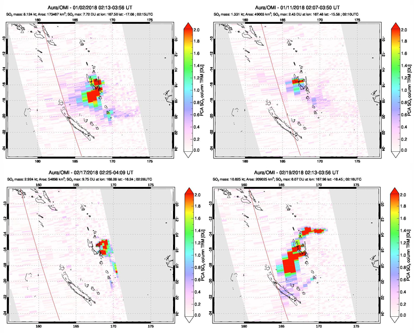
A larger eruption on 16 February generated an ash plume that rose to 4.6 km altitude and initially drifted NE. Continuous ash emission extended as high as 5.5 km through 17 February and drifted SE and then S. By the next day, the constant emissions were still visible in satellite imagery, estimated at 4.6 km altitude; the main plume was drifting E with a remnant moving to the SW, finally dissipating on 19 February (figure 54). Ash emissions were visible in infrared imagery at about 3.9 km altitude on 23 February. Ongoing explosions were observed in the webcam on 23 and 24 February; ash was visible in satellite imagery until the end of the day on 24 February. A brief explosion observed in the webcam around sunrise on 27 February generated a small ash plume that rose to 3.1 km altitude and drifted SE. Moderate sulfur dioxide emissions were recorded a number of times during January and February (figure 55).
Activity during March 2018. The frequency and volume of ash emissions increased significantly during March 2018. Ash plumes were visible in satellite imagery during 3-6 March 2018. The initial plume rose to 3.7 km altitude and drifted NE, rising to 3.9 on 4 March and drifting N. The following day plumes rose to 4.6 km. By 6 March the plume was lower, drifting NW at 2.4 km altitude. A series of continuous low-level ash emissions were visible in satellite and webcam imagery every day from 11-19 March (figure 56). They initially drifted SE and SW and then moved to the W on 15 March at altitudes of generally 2.4-3.1 km, occasionally higher. The plumes drifted N and W during 17-19 March. This increase in ash emissions affecting local villages led VMGD to raise the alert level from 2 to 3 on 18 March 2018. They noted that activity was similar to the previous October but with more sustained ash emissions.
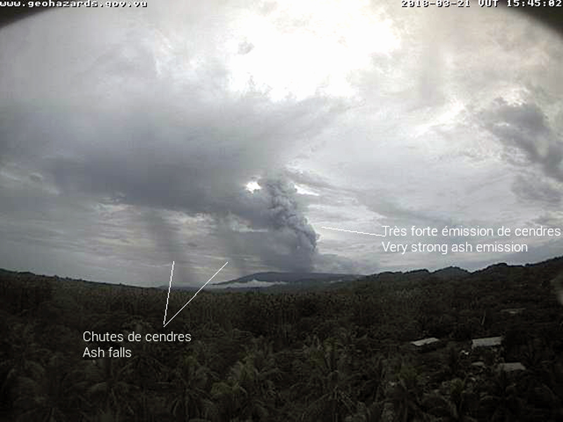
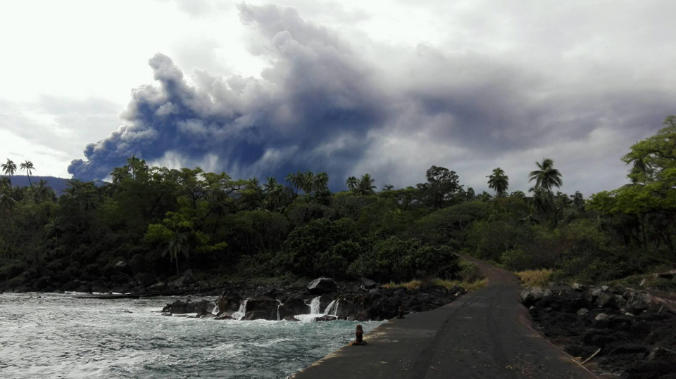
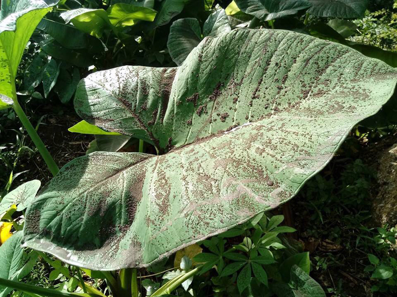
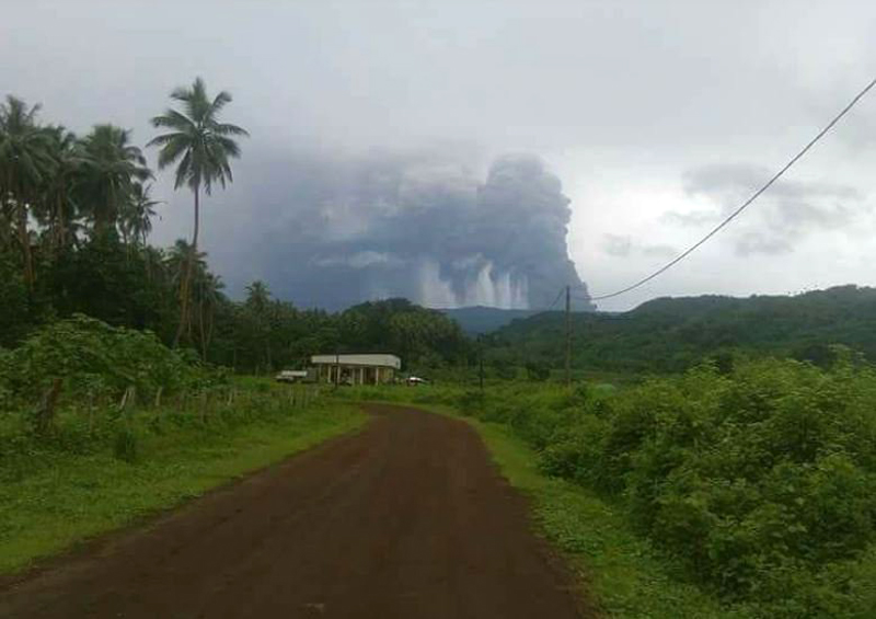
Local observers reported an explosion on 21 March that rose to 3.4 km altitude and drifted SW (figures 57-59). Continuous emissions through the end of the month were discernible in either satellite imagery or the webcam each day. Plume altitudes ranged from 3.1 to 4.9 km altitude, drifting in several directions. Significant ashfall began affecting local villages, destroying crops and livestock, and collapsing structures during the second half of March.
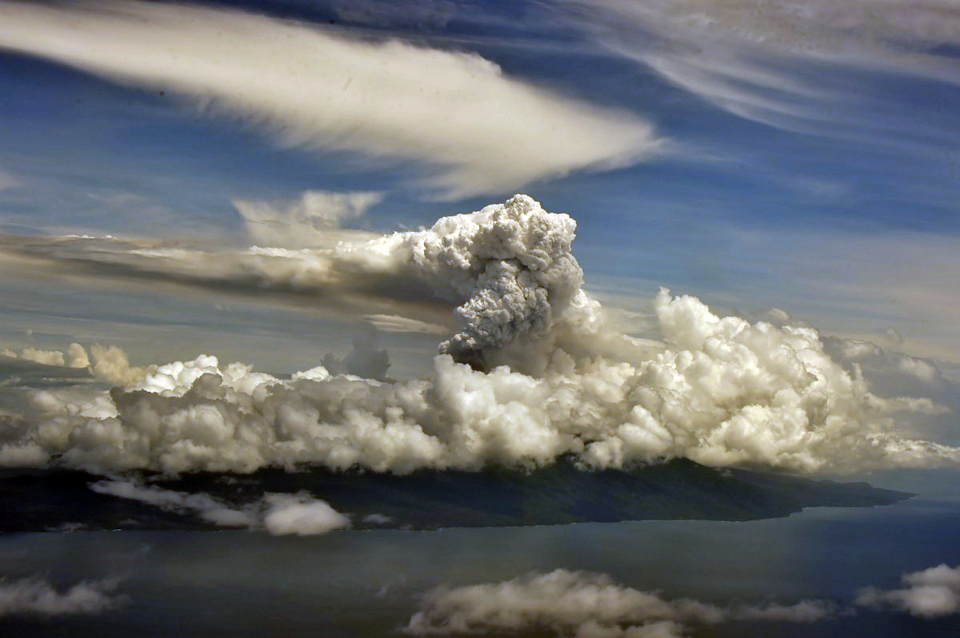
Local news reports on 25 March noted that ejecta from the previous evening was visible over 70 km away to the SW by residents on Espiritu Santo Island, and small amounts of ash fell on Pentecost Island, 60 km SE (figure 60). According to the Vanuatu Independent, Virgin Australia cancelled flights to Vanuatu on 25 March. The New Zealand Defence Force did an aerial survey on 26 March and observed a large ash plume rising several kilometers (figure 61). Radio New Zealand reported on 30 March that large amounts of ashfall and acid rain had damaged crops, water supplies and buildings on Ambae (figures 62). A New Zealand GNS Science volcanologist reported that gardens were covered by ash and limbs on trees were broken. Some of the roofs over buildings and water supplies had collapsed due to the weight of the volcanic ash. Heavy ashfall in the S and NW parts of the island at the end of the month resulted in evacuations of several villages in the affected areas.
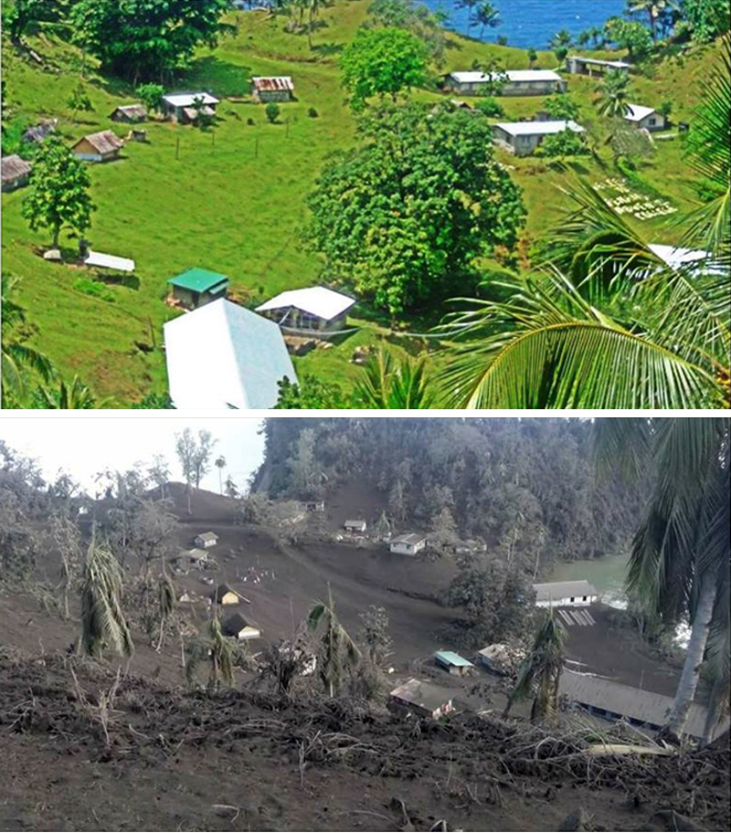
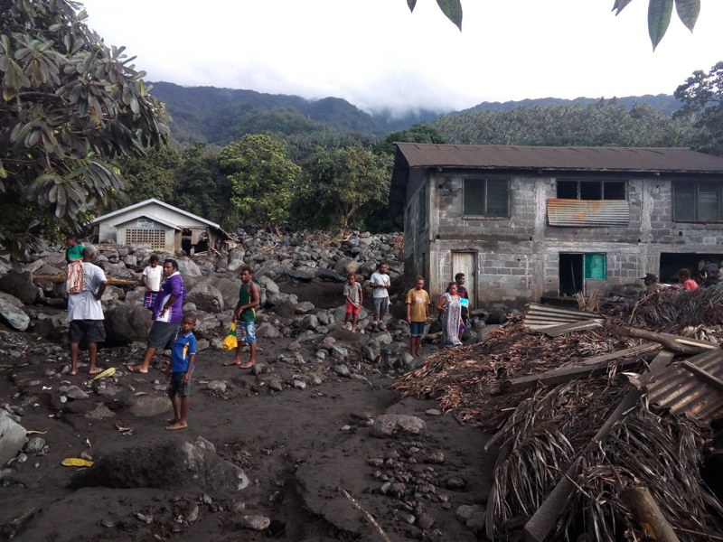
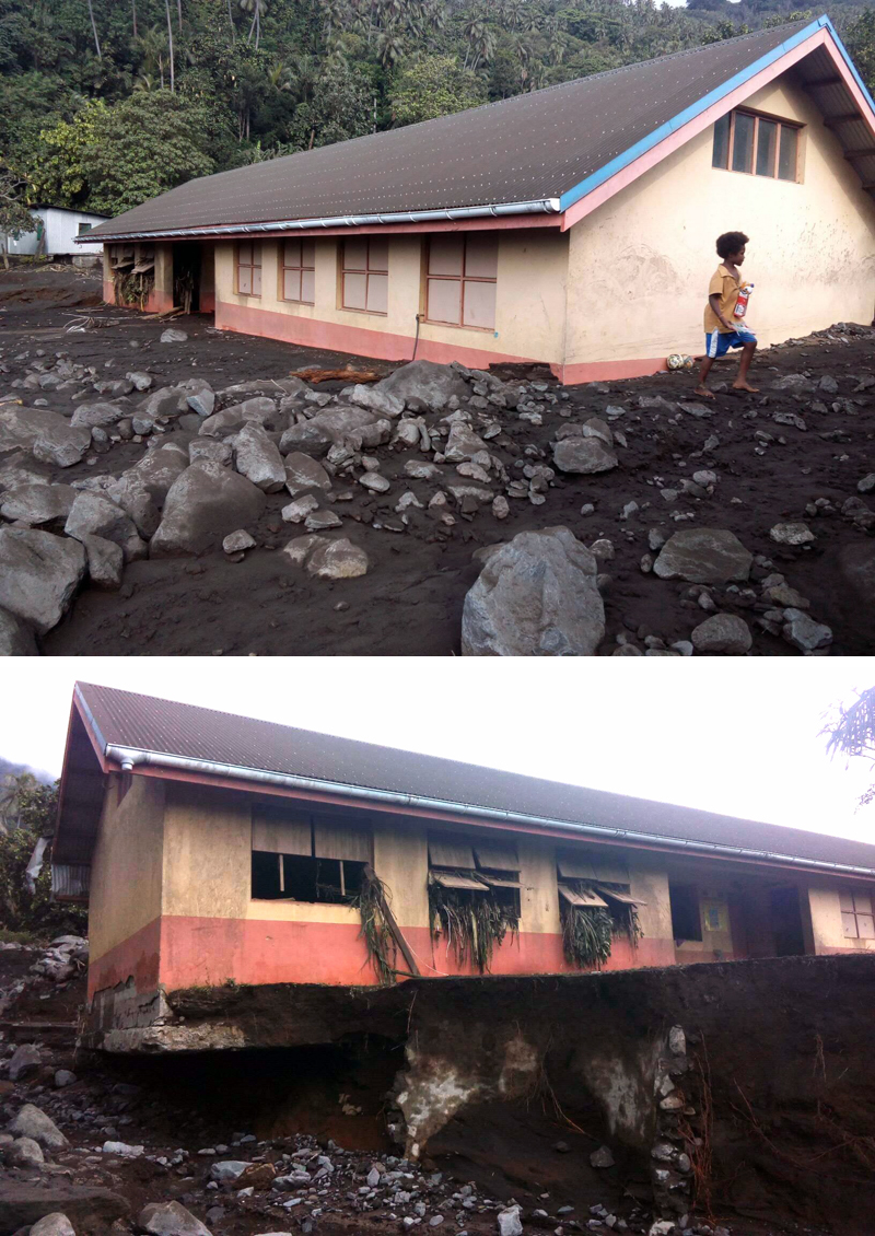
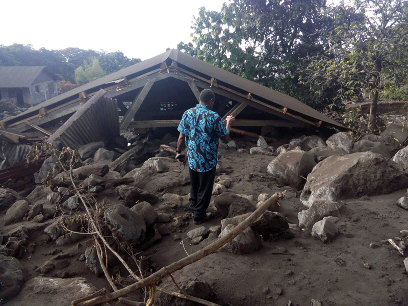
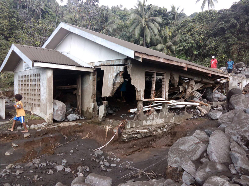
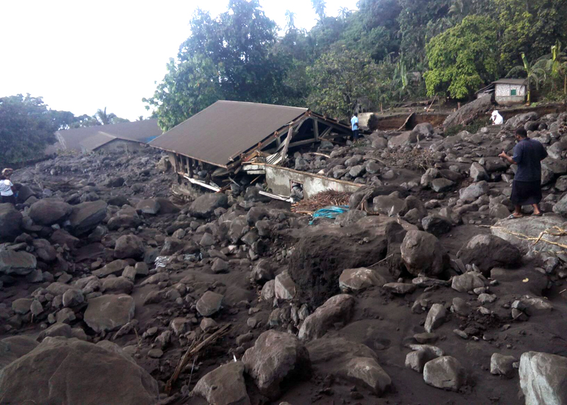
The village of Waluebue on the N side of Ambae was badly damaged by a lahar during the night of 30-31 March. Homes and churches were destroyed from the mud and large boulders in the debris flow. All residents were safely evacuated (figures 63-67).
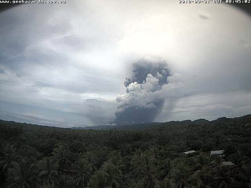
A new series of high-altitude ash emissions were reported by the Washington VAAC beginning on 30 March (figure 68). Early reports from satellite images and webcams indicated an ash plume at 6.1 km altitude. This was followed within the hour of confirmation from satellite imagery of the plume at 13.7 km altitude moving NW. By the following morning, two plumes were visible, one drifting S at 6.1 km and a second drifting NW at 13.7 km altitude. Meteoric clouds prevented observations later that day, but by 1 April, intermittent explosions were producing plumes moving E at an estimated altitude of 3.0 km, and SE estimated at 6.1 km altitude.
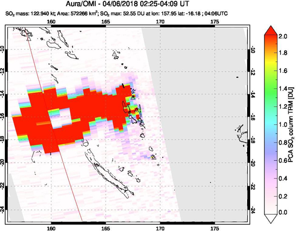
Activity during April-June 2018. New eruptions occurred overnight during 5-6 April 2018 that generated an ash plume and a large distinct SO2 plume. Meteoric clouds and darkness prevented observation of the ash plume, but the SO2 signal was clearly visible on false-color satellite imagery. The plume initially rose to 7.3 km altitude and drifted W; a few hours later, it rose to 12.2 km. With a Dobson Unit measurement of 52.55 units, it was one of the strongest SO2 plumes measured on the planet since 2015, according to Simon Carn of Michigan Technological University (figure 69). An ongoing eruption was visible in the webcam on 6 April, but meteoric clouds again prevented observation in satellite data. A cluster of lightning strikes was detected by the World Wide Lightning Location Network (WWLLN) around the reported time of the eruption, according to Simon Carn. Intermittent low-level ash emissions were confirmed in the webcam on 8 April, estimated to be moving NE and E at 3.0-4.9 km altitude.
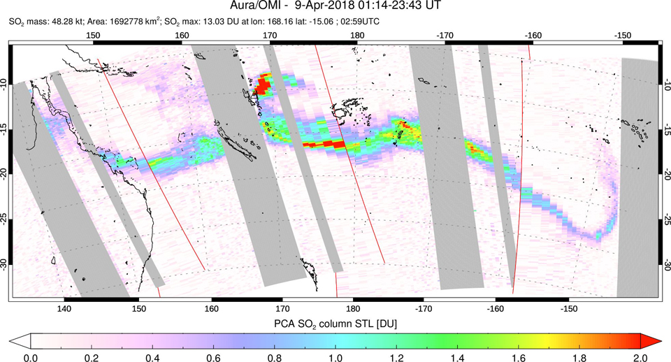
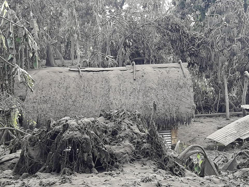
Ash from a continuous low-level eruption during 9-10 April 2018 was clearly visible in the webcam and partly visible in satellite imagery drifting E and NE at 4.3-4.9 km altitude. The SO2 plume from the eruption stretched across most of the South Pacific (figure 70). Ashfall from the plume spread across a large area of the island causing substantial damage in local communities (figures 71 and 72).
The ash plume height increased significantly on 11 April to 9.1 km altitude and drifted SE according to the Wellington VAAC. Planet Lab images showed the plume covering the N half of the island a short time later (figure 73). The following day, the plume altitude gradually lowered from 4.6 to 1.8 km and drifted N, then NW. Local communities reported intermittent low-level ash emissions and localized ashfall late on 12 April; this was the last report of ash emissions for April. Thick meteoric and ash clouds enveloped much of the island as seen in social media video on 12 April.
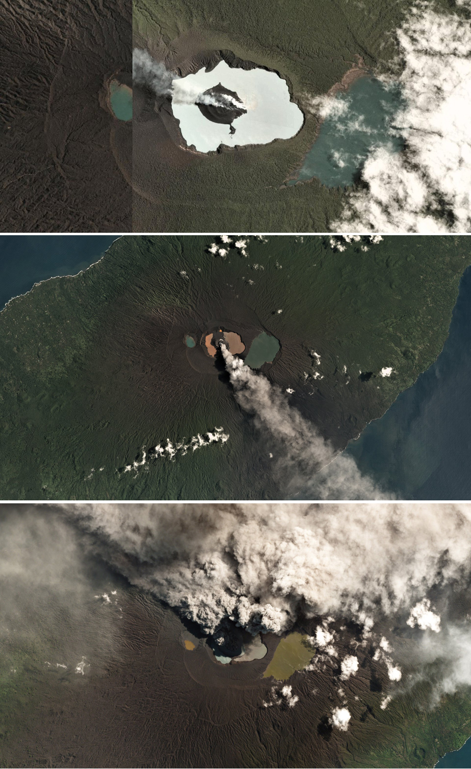
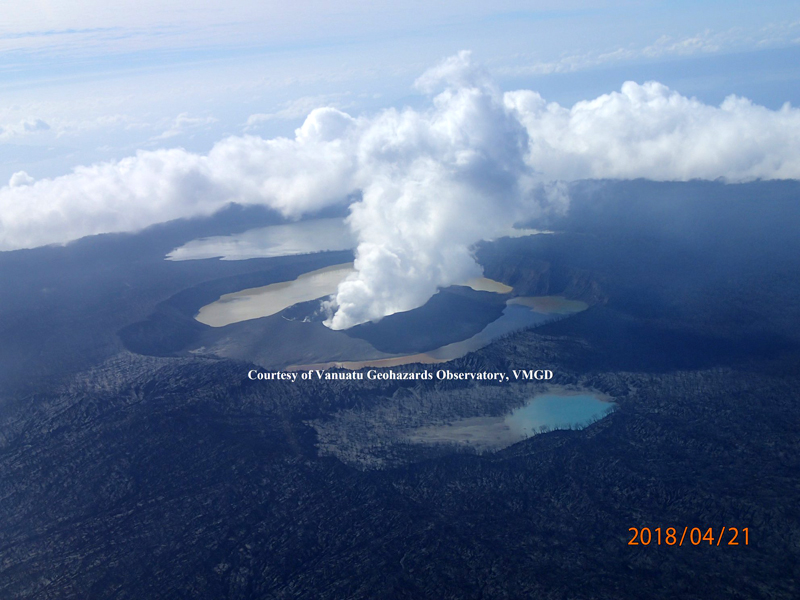
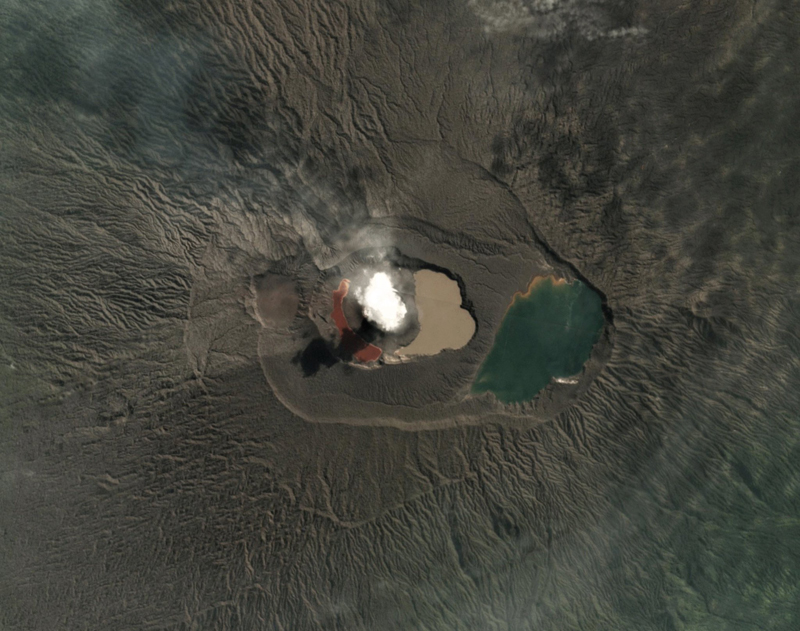
According to the Vanuatu Daily Post on 16 April 2018, the Council of Ministers for Vanuatu declared their intent to seek help from International Relief Organizations to evacuate the island's population after the latest episodes of extensive ashfall destroyed much of the infrastructure. Photographs from an overflight by VGMD on 21 April 2018 showed the increased size of the pyroclastic cone inside Lake Voui dividing the lake into two segments, one nearly consumed by the cone (figure 74). They reported small eruptions on 23 and 27 April; these were the last ash emissions until the end of June 2018.
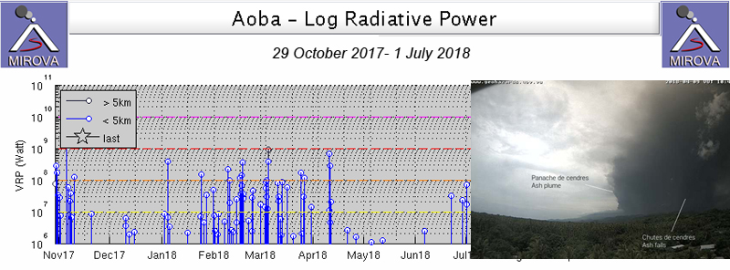
The thermal activity recorded by the MODVOLC and MIROVA systems corresponded with the observations of explosions and ash emissions. There were MODVOLC thermal alerts issued each month from January through 10 April 2018, with strong, multi-alert periods in February and March; these data were similar to the MIROVA signal for the period, which also showed increased activity during the same time (figure 75).
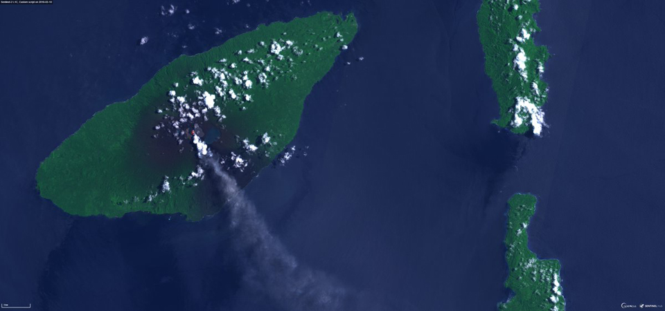
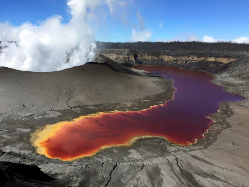
By the end of May 2018, Manaro Ngoru, the small water body on the W side of the summit was dry; Lake Voui, divided into two segments by the pyroclastic cone, had a small amount of orange-brown water in the W half, and muddy brown water in the E half (figures 76 and 77). Steam plumes rose continuously from the cone, but no ash emissions were observed.
VMGB issued a volcano alert on 7 June 2018, announcing that they had lowered the Alert Level from 3 to 2, due to the reduced activity at Ambae during late April and May. Radio New Zealand reported that on 9 June, the Vanuatu government announced plans to move its Penama Province capital due to the ongoing eruption. The Penama Council agreed to relocate its headquarters from Saatamaa in Eastern Ambae to Loltong in North Pentacost. The Penama Province is one of six in Vanuatu and includes the three islands of Ambae, Maewo, and Pentecost.
The Wellington VAAC issued an ash advisory from a low-level ash emission on 21 June 2018. It was clearly visible in satellite imagery, and rose to 3 km altitude, drifting SE. That was the last activity reported until a large new ash plume was recorded in the webcam on 1 July 2018.
Geological Summary. The island of Ambae, also known as Aoba, is a massive 2,500 km3 basaltic shield that is the most voluminous volcano of the New Hebrides archipelago. A pronounced NE-SW-trending rift zone with numerous scoria cones gives the 16 x 38 km island an elongated form. A broad pyroclastic cone containing three crater lakes (Manaro Ngoru, Voui, and Manaro Lakua) is located at the summit within the youngest of at least two nested calderas, the largest of which is 6 km in diameter. That large central edifice is also called Manaro Voui or Lombenben volcano. Post-caldera explosive eruptions formed the summit craters about 360 years ago. A tuff cone was constructed within Lake Voui (or Vui) about 60 years later. The latest known flank eruption, about 300 years ago, destroyed the population of the Nduindui area near the western coast.
Information Contacts: Geo-Hazards Division, Vanuatu Meteorology and Geo-Hazards Department (VMGD), Ministry of Climate Change Adaptation, Meteorology, Geo-Hazards, Energy, Environment and Disaster Management, Private Mail Bag 9054, Lini Highway, Port Vila, Vanuatu (URL: http://www.vmgd.gov.vu/, https://www.facebook.com/VanuatuGeohazardsObservatory/); Wellington Volcanic Ash Advisory Centre (VAAC), Meteorological Service of New Zealand Ltd (MetService), PO Box 722, Wellington, New Zealand (URL: http://www.metservice.com/vaac/, http://www.ssd.noaa.gov/VAAC/OTH/NZ/messages.html); NASA Goddard Space Flight Center (NASA/GSFC), Global Sulfur Dioxide Monitoring Page, Atmospheric Chemistry and Dynamics Laboratory, 8800 Greenbelt Road, Goddard, Maryland, USA (URL: https://so2.gsfc.nasa.gov/); European Space Agency (ESA), Copernicus (URL: http://www.esa.int/Our_Activities/Observing_the_Earth/Copernicus; MIROVA (Middle InfraRed Observation of Volcanic Activity), a collaborative project between the Universities of Turin and Florence (Italy) supported by the Centre for Volcanic Risk of the Italian Civil Protection Department (URL: http://www.mirovaweb.it/); Hawai'i Institute of Geophysics and Planetology (HIGP) - MODVOLC Thermal Alerts System, School of Ocean and Earth Science and Technology (SOEST), Univ. of Hawai'i, 2525 Correa Road, Honolulu, HI 96822, USA (URL: http://modis.higp.hawaii.edu/); New Zealand Defence Force (NZDF), Wellington, New Zealand (URL: http://www.nzdf.mil.nz/, Twitter: @NZDefenceForce); Vanuatu Daily Post (URL: http://dailypost.vu/news/flash-appeal/article_7c929c1e-dda3-5eab-925b-c814e04eeacb.html); Dan McGarry, Vanuatu Daily Post (Twitter: @dailypostdan); Vanuatu Independent News Magazine, Port Vila, Vanuatu (URL: https://vanuatuindependent.com/2018/03/26/flight-cancelled-due-to-volcanic-ash/); Simon Carn, Dept of Geological and Mining Engineering and Sciences, Michigan Technological University, 1400 Townsend Dr., Houghton, MI 49931, USA (URL: http://www.volcarno.com/, http://so2.umbc.edu/omi/); Radio New Zealand, 155 The Terrace, Wellington 6011, New Zealand (URL: https://www.radionz.co.nz/international/pacific-news/359231/vanuatu-provincial-capital-moves-due-to-volcano); Bani Philipson, Observatoire de Physique du Globe de Clermont-Ferrand (OPGC) and Institut de Recherche pour le Developpement (IRD), Laboratoire Magmas et Volcans (LMV), University Campus of Cézeaux, 6 Blaise Pascal Avenue, TSA 60026 - CS 60026, 63178 AUBIERE Cedex, France (URL: http://lmv.univ-bpclermont.fr/bani-philipson/, Twitter: @philipsonbani); David Sarginson (Facebook: URL: https://www.facebook.com/david.sarginson.16); Clifford Tarisimbi (Facebook: https://www.facebook.com/profile.php?id=100009930510696); Wilfred Woodrow (Facebook: https://www.facebook.com/groups/558036627684741/permalink/974980079323725); Planet Labs Inc. (URL: http://www.planet.com/).