Report on Fernandina (Ecuador) — August 2018

Bulletin of the Global Volcanism Network, vol. 43, no. 8 (August 2018)
Managing Editor: Edward Venzke.
Edited by A. Elizabeth Crafford.
Fernandina (Ecuador) Brief eruptive episode 16-22 June 2018, lava flows down N flank into the ocean
Please cite this report as:
Global Volcanism Program, 2018. Report on Fernandina (Ecuador) (Crafford, A.E., and Venzke, E., eds.). Bulletin of the Global Volcanism Network, 43:8. Smithsonian Institution. https://doi.org/10.5479/si.GVP.BGVN201808-353010
Fernandina
Ecuador
0.37°S, 91.55°W; summit elev. 1476 m
All times are local (unless otherwise noted)
Eruptions at Fernandina Island in the Galapagos often occur from vents located around the caldera rim along boundary faults and fissures, and occasionally from side vents on the flank. The last eruption in September 2017 lasted for about one week and originated from a fissure at the SW rim of the caldera. A new eruption in June 2018 lasted for less than a week and originated from a fissure on the N flank of the volcano. Information about the latest eruption was provided by Ecuador's Institudo Geofisica, Escuela Politécnica Nacional (IG-EPN), the Dirección del Parque Nacional Galápagos (PNG), the Washington Volcanic Ash Advisory Center (VAAC), and several sources of satellite data.
A seismic swarm on 16 June 2018 preceded a brief eruptive episode at Fernandina that lasted from 16 to 22 June. Lava erupted from a radial fissure and quickly flowed to the sea down the N flank. Emissions were primarily gas with low ash content and included substantial SO2. After two days of activity, seismicity returned to background levels on 18 June. Park Officials reported only cooling flows and lava no longer entering the sea by 21 June 2018.
Eruption of June 2018. The first evidence of a new eruptive event at Fernandina began as a seismic swarm on 16 June 2018. The largest event (M 4.1) was located 4 km off the NE flank of the island. An active eruption was confirmed a few hours later by guides on a passing boat and by satellite images which indicated a thermal anomaly on the N flank. The eruption consisted of a lava flow on the NNE flank and a gas plume that rose 2-3 km and drifted SW (figure 32). The lava flow quickly reached the ocean, generating steam and gas explosions that were visible from Canal Bolívar, the narrow channel on the NE side of Isla Fernandina that separates it from Isla Isabela (figure 33).
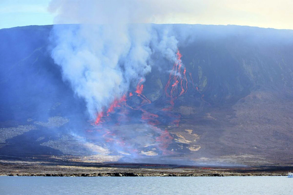 |
Figure 32. Lava from a new eruption at Fernandina flowed quickly down the N flank of the island to the ocean on 16 June 2018, according to Parque Nacional Galapagos officials. Courtesy of Parque Nacional Galapagos. |
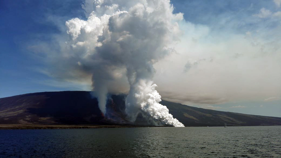 |
Figure 33. Explosions produced large plumes of steam as lava reached the ocean on the N flank of Fernandina on 16 June 2018. Courtesy of Parque Nacional Galapagos. |
Observations by PNG officials and visitors indicated that lava flows came from a radial fissure on the NNE flank, and produced gas plumes with low ash content that rose 2-3 km and drifted more than 250 km WNW (figures 34 and 35). The Washington VAAC detected an ash and gas plume in visible satellite imagery drifting W from the summit at 2.4 km altitude late in the day on 16 June, along with a significant thermal signature in infrared imagery. A second gas-and-ash plume at the same altitude drifted WNW the following day for a few hours before dissipating. After two days of intense eruptive activity, seismic tremor activity had declined significantly to background levels by noon on 18 June.
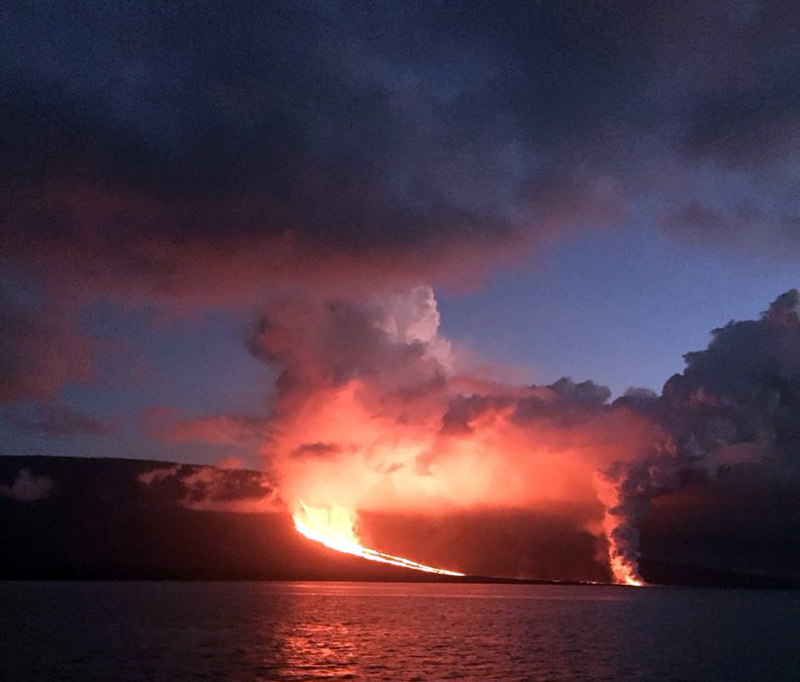 |
Figure 34. Incandescent lava flows from the eruption of Fernandina produced large plumes of water vapor as they reached the sea during the evening of 16 June 2018. Courtesy of Parque Nacional Galapagos. |
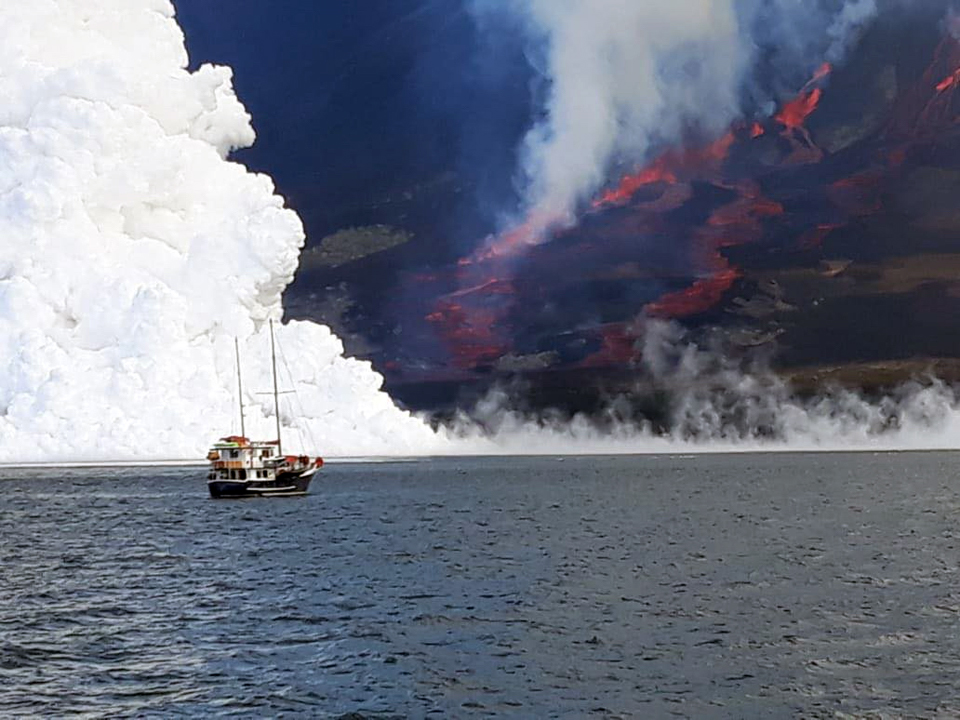 |
Figure 35. Incandescent lava reached the sea during 16-18 June 2018 at Fernandina from a brief eruptive episode. The lava flowed down the N flank. Courtesy of CNH Tours, posted 20 June 2018. |
A strong pulse of SO2 emissions that drifted W was recorded by satellite instruments on 17 and 18 June 2018 (figure 36). The MODVOLC thermal alert system also recorded a surge of over 100 thermal anomalies from infrared satellite imagery that lasted from 17 to 22 June. More than half of the anomalies appeared on 17 June. The alert pixels were all clustered on the N flank. The MIROVA system also record the spike in thermal activity on 17 June and indicated that the heat source was more than 5 km from the summit (figure 37).
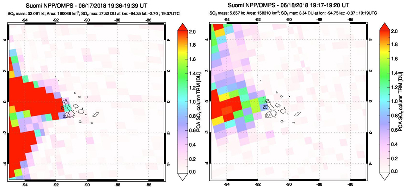 |
Figure 36. A strong pulse of SO2 issued from Fernandina on 17 June 2018 and was recorded by the OMPS instrument on the SUOMI NPP satellite. The plume drifted W and measured at about 27 Dobson Units (DU). Courtesy of NASA Goddard Space Flight Center. |
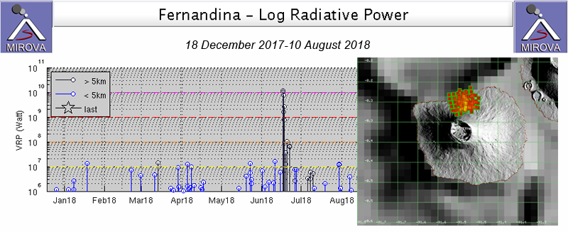 |
Figure 37. The MIROVA system log radiative power measurement for Fernandina showed a spike of thermal activity on 16-17 June 2018 that coincided with the fissure eruption that sent lava flows down the N flank of the volcano into the sea. The black bars indicate a heat source more than 5 km from the summit. The MODVOLC thermal alert system detected over 100 thermal alerts at Fernandina between 17 and 22 June 2018, concurring with observations of lava flows on the N flank of the volcano. Courtesy of MIROVA and MODVOLC. |
By 21 June 2018 PNG officials reported that lava was no longer reaching the ocean, but steam from cooling flows was visible at the coastline and over the area of the new flows (figure 38).
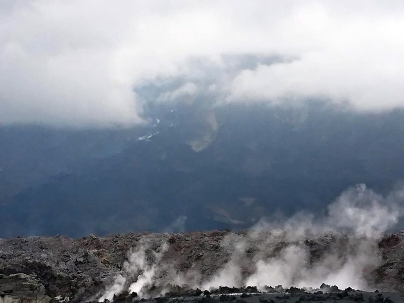 |
Figure 38. By 21 June 2018 active lava flows were no longer reaching the ocean at Fernandina, although steam from cooling lava was still visible near the coast and along the N flank. Courtesy of Parque Nacional Galapagos. |
Geological Summary. Fernandina, the most active of Galápagos volcanoes and the one closest to the Galápagos mantle plume, is a basaltic shield volcano with a deep 5 x 6.5 km summit caldera. The volcano displays the classic "overturned soup bowl" profile of Galápagos shield volcanoes. Its caldera is elongated in a NW-SE direction and formed during several episodes of collapse. Circumferential fissures surround the caldera and were instrumental in growth of the volcano. Reporting has been poor in this uninhabited western end of the archipelago, and even a 1981 eruption was not witnessed at the time. In 1968 the caldera floor dropped 350 m following a major explosive eruption. Subsequent eruptions, mostly from vents located on or near the caldera boundary faults, have produced lava flows inside the caldera as well as those in 1995 that reached the coast from a SW-flank vent. Collapse of a nearly 1 km3 section of the east caldera wall during an eruption in 1988 produced a debris-avalanche deposit that covered much of the caldera floor and absorbed the caldera lake.
Information Contacts: Instituto Geofísico (IG), Escuela Politécnica Nacional, Casilla 17-01-2759, Quito, Ecuador (URL: http://www.igepn.edu.ec/); Dirección del Parque Nacional Galápagos (DPNG), Av. Charles Darwin y S/N, Isla Santa Cruz, Galápagos, Ecuador (URL: http://www.galapagos.gob.ec/, Twitter: @parquegalapagos); Hawai'i Institute of Geophysics and Planetology (HIGP) - MODVOLC Thermal Alerts System, School of Ocean and Earth Science and Technology (SOEST), Univ. of Hawai'i, 2525 Correa Road, Honolulu, HI 96822, USA (URL: http://modis.higp.hawaii.edu/); MIROVA (Middle InfraRed Observation of Volcanic Activity), a collaborative project between the Universities of Turin and Florence (Italy) supported by the Centre for Volcanic Risk of the Italian Civil Protection Department (URL: http://www.mirovaweb.it/); NASA Goddard Space Flight Center (NASA/GSFC), Global Sulfur Dioxide Monitoring Page, Atmospheric Chemistry and Dynamics Laboratory, 8800 Greenbelt Road, Goddard, Maryland, USA (URL: https://so2.gsfc.nasa.gov/); Cultural and Natural Heritage Tours, Galapagos, (CNH Tours), 14 Kilbarry Crescent, Ottawa, Ontario, K1K 0G8, Canada (URL: https://www.cnhtours.com/, Twitter: @CNHtours).