Report on Mayon (Philippines) — October 2018

Bulletin of the Global Volcanism Network, vol. 43, no. 10 (October 2018)
Managing Editor: Edward Venzke.
Edited by Janine B. Krippner.
Mayon (Philippines) Low activity during April-September with some ash plumes and ongoing crater incandescence
Please cite this report as:
Global Volcanism Program, 2018. Report on Mayon (Philippines) (Krippner, J.B., and Venzke, E., eds.). Bulletin of the Global Volcanism Network, 43:10. Smithsonian Institution. https://doi.org/10.5479/si.GVP.BGVN201810-273030
Mayon
Philippines
13.257°N, 123.685°E; summit elev. 2462 m
All times are local (unless otherwise noted)
Mayon is a frequently active volcano in the Philippines that produces ash plumes, lava flows, pyroclastic flows, and lahars. In early 2018, eruptive activity included lava fountaining that reached 700 m above the summit, and lava flows that traveled down the flanks and collapsed to produce pyroclastic flows (figure 39). Lava fountaining and lava flows decreased then ceased towards late March. Lava effusion was last detected on 18 March 2018, and the last pyroclastic flow for this eruptive episode occurred on 27 March 2018 (see BVGN 43:04). The hazard status for was lowered from alert level 4 to 3 (on a scale of 0 to 5) on 6 March 2018 due to decreased seismicity and degassing; the level was lowered again to 2 on 29 March. This report summarizes the activity during April through September 2018 and is based on daily bulletins issued by the Philippine Institute of Volcanology and Seismology (PHIVOLCS) and satellite data.
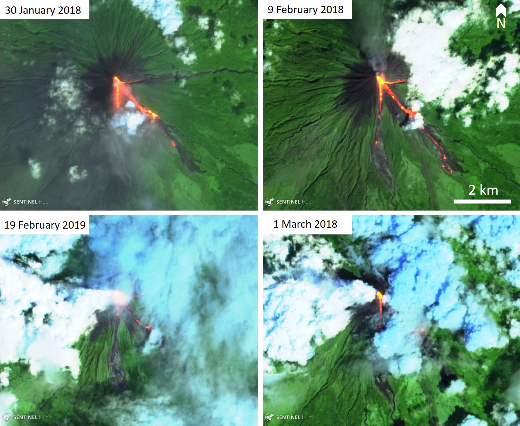 |
Figure 39. Sentinel-2 thermal satellite images showing the lava flow activity at Mayon during January through March 2018. Three lava flow lobes flowed down the Mi-isi, Bonga-Buyuan, and Basud channels, and are shown in bright orange/red in these images. False color images created using bands 12, 11, 4. Courtesy of Sentinel Hub Playground. |
The hazard status remained on Alert level 2 (increasing unrest) throughout the reporting period. Activity was minimal with low seismicity (zero to four per day) and a total of 19 rockfall events throughout the entire period. White to light-brown plumes that reached a maximum of 1 km above the crater were observed almost every day from April through September (figure 40). Two short-lived light brown plumes were noted on 27 and 28 August and both reached 200 m above the crater.
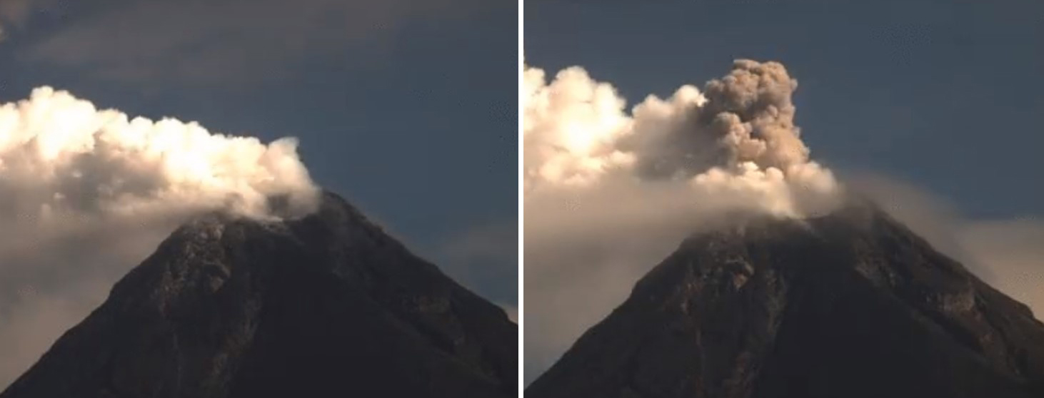 |
Figure 40. An emission of white steam-and-gas at Mayon and a dilute brown plume that reached 200 m above the crater was seen on 24 May 2018. Courtesy of PHIVOLCS. |
On the days that sulfur dioxide was measured, the amount ranged from 436 to 2,800 tons per day (figure 41). Mayon remains inflated relative to 2010 baselines but the edifice has experienced deflation since 20 February, a period of inflation from 2-14 April, and slight inflation of the mid-slopes beginning 5 May, which then became more pronounced beginning 25 June. No other notable inflation or deflation was described throughout the reporting period.
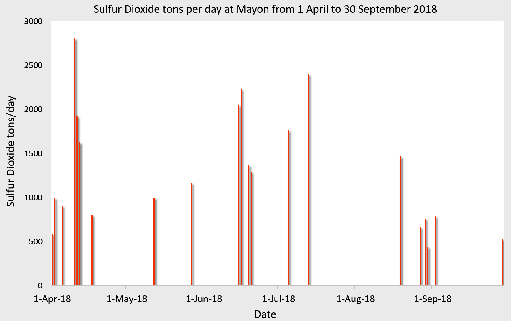 |
Figure 41. Measurements of sulfur dioxide output at Mayon during 1 April-30 September 2018. Data courtesy of PHIVOLCS. |
Incandescence at the summit was observed almost every night (when weather permitted) from April through to the end of September 2018, and this elevated crater temperature is also seen in satellite thermal imagery (figure 42). Thermal satellite data showed a slight increase in output during April through to June, although not as high as the earlier 2018 activity, with a decline in thermal output starting in July (figure 43).
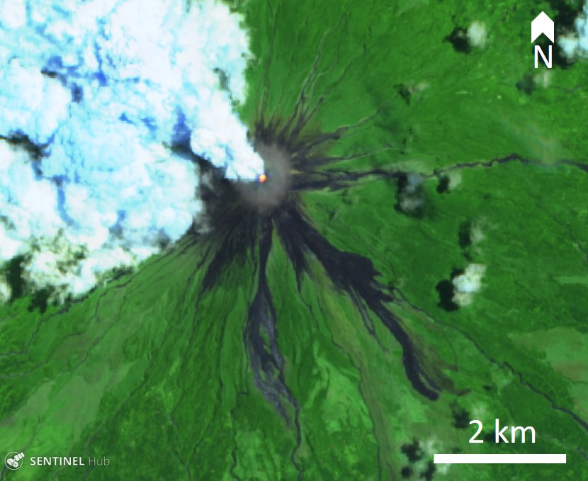 |
Figure 42. Sentinel-2 thermal satellite image showing an elevated thermal signature in the crater of Mayon and a steam-and-gas plume on 15 May 2018. Similar indications of activity in the crater were frequently imaged on cloud-free days from April through September. False color image created using bands 12, 11, 4. Courtesy of Sentinel Hub Playground. |
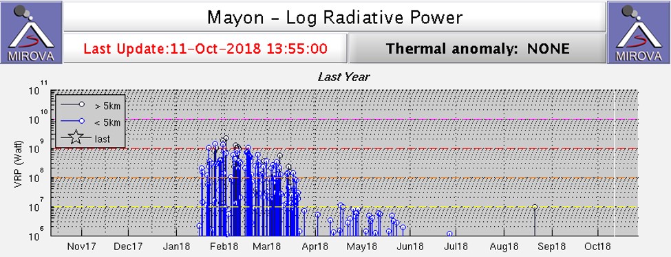 |
Figure 43. Log radiative power MIROVA plot of MODIS thermal data for the year ending 11 October 2018 at Mayon. An elevated period of activity reflecting the lava flows in January through March is notable, followed by a second period of lower intensity activity during May into June, then a prolonged period of reduced activity through to the end of the reporting period; the August anomaly was not at the volcano. Courtesy of MIROVA. |
Geological Summary. Symmetrical Mayon, which rises above the Albay Gulf NW of Legazpi City, is the most active volcano of the Philippines. The steep upper slopes are capped by a small summit crater. Recorded eruptions since 1616 CE range from Strombolian to basaltic Plinian, with cyclical activity beginning with basaltic eruptions, followed by longer periods of andesitic lava flows. Eruptions occur predominately from the central conduit and have also produced lava flows that travel far down the flanks. Pyroclastic density currents and mudflows have commonly swept down many of the approximately 40 ravines that radiate from the summit and have often damaged populated lowland areas. A violent eruption in 1814 killed more than 1,200 people and devastated several towns.
Information Contacts: Philippine Institute of Volcanology and Seismology (PHIVOLCS), Department of Science and Technology, University of the Philippines Campus, Diliman, Quezon City, Philippines (URL: http://www.phivolcs.dost.gov.ph/); MIROVA (Middle InfraRed Observation of Volcanic Activity), a collaborative project between the Universities of Turin and Florence (Italy) supported by the Centre for Volcanic Risk of the Italian Civil Protection Department (URL: http://www.mirovaweb.it/); Sentinel Hub Playground (URL: https://www.sentinel-hub.com/explore/sentinel-playground).