Report on Saunders (United Kingdom) — October 2018
Bulletin of the Global Volcanism Network, vol. 43, no. 10 (October 2018)
Managing Editor: Edward Venzke.
Edited by A. Elizabeth Crafford.
Saunders (United Kingdom) Intermittent thermal pulses and satellite imagery hotspots during September 2016-September 2018
Please cite this report as:
Global Volcanism Program, 2018. Report on Saunders (United Kingdom) (Crafford, A.E., and Venzke, E., eds.). Bulletin of the Global Volcanism Network, 43:10. Smithsonian Institution. https://doi.org/10.5479/si.GVP.BGVN201810-390090
Saunders
United Kingdom
57.8°S, 26.483°W; summit elev. 843 m
All times are local (unless otherwise noted)
Historical observations of eruptive activity on ice-covered Mount Michael stratovolcano on Saunders Island in the South Sandwich Islands were not recorded until the early 19th century at this remote site in the southernmost Atlantic Ocean. With the advent of satellite observation technology, indications of more frequent eruptive activity have become apparent. The last confirmed eruption evidenced by MODVOLC thermal alerts was during August-October 2015 (BGVN 41:02). Limited thermal anomaly data and satellite imagery since then have indicated intermittent activity through September 2018. Information for this report comes from MODVOLC and MIROVA thermal anomaly data and Sentinel-2, Landsat, and NASA Terra satellite imagery.
Evidence for thermal activity at Mount Michael tapered off in MIROVA data from October 2015 through January 2016. MODVOLC thermal alerts reappeared on 28 September 2016 and recurred intermittently through 6 January 2017. Low-level MIROVA thermal signals appeared in June and September-November 2017. During January-September 2018, evidence for some type of thermal or eruptive activity was recorded from either MODVOLC, MIROVA, or satellite imagery each month except for May and June.
Although MODVOLC thermal alerts at Mount Michael ended on 8 October 2015, the MIROVA radiative power data showed intermittent pulses of decreasing energy into early January 2016 (figure 10, BGVN 41:02). At a high-latitude, frequently cloud-covered site such as Saunders Island, this could be indicative of continued eruptive activity. A white plume in low resolution NASA's Terra satellite data was spotted drifting away from Saunders in April 2016, but no thermal activity was reported. The only high-confidence data available from April 2016 through May 2017 is from the MODVOLC thermal alert system, which recorded two thermal alerts on 28 September 2016, one the next day, one on 30 October, and eight alerts on four days in November. Activity continued into January 2017 with one alert on 17 December 2016, and six alerts on 2 and 6 January 2017 (figure 11).
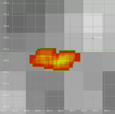 |
Figure 11. Seventeen MODVOLC thermal alerts between 28 September 2016 and 6 January 2017 were the best evidence available for eruptive activity on Saunders Island from April 2016 through May 2017. Courtesy of MODVOLC. |
A low-level log radiative power MIROVA signal appeared in early June 2017; two more signals appeared in September 2017, one in early October and one in late November (figure 12). Additional signals plotted as more than 5 km from the source may or may not reflect activity from the volcano. Steam plumes were visible in NASA Terra satellite images drifting away from the island in August, October, and December 2017, but no thermal signatures were captured.
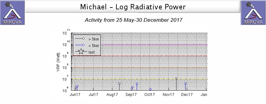 |
Figure 12. The MIROVA log radiative power graph for Mount Michael on Saunders Island from 25 May-30 December 2017 showed intermittent heat sources that indicated possible eruptive activity each month except July and December. Location uncertainty makes the distinction between greater and less than 5 km summit distance unclear. |
More sources of evidence for activity became available in 2018 with the addition of the Sentinel-2 satellite data during the months of February-April and September. Multiple thermal signals appeared from MIROVA in January 2018 (figure 13), and the first Sentinel-2 satellite image showed a distinct hotspot at the summit on 10 February (figure 14).
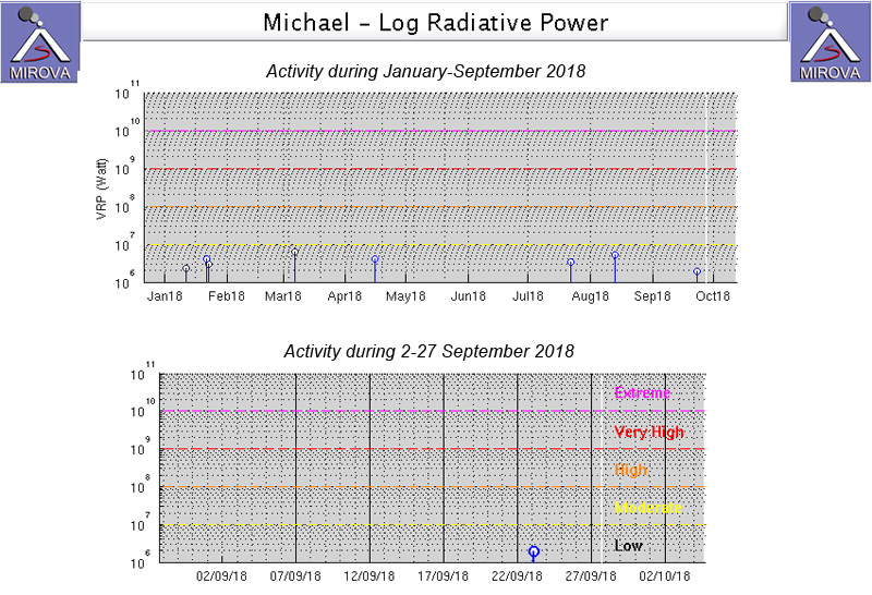 |
Figure 13. MIROVA thermal data for January-September 2018 indicated intermittent thermal anomaly signals in January, March, April, and July-September (top). A Sentinel-2 image with a hotspot was captured on 23 September, the same day as the MIROVA thermal signal (bottom). Courtesy of MIROVA. |
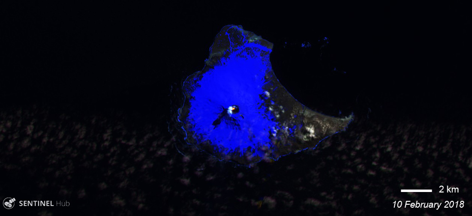 |
Figure 14. A Sentinel-2 image of Saunders Island on 10 February 2018 revealed a distinct hotspot and small steam plume rising from the summit crater of Mount Michael. Sentinel-2 image with Atmospheric Penetration view (bands 12, 11, and 8A), courtesy of Sentinel Hub Playground. |
A MODVOLC thermal alert appeared on 26 March 2019 followed by a significant hotspot signal in Sentinel-2 imagery on 29 March (figure 15). The hotspot was still present along with a substantial steam plume on 3 April 2018. Sentinel-2 imagery on 11 April revealed a large steam plume and cloud cover, but no hotspot.
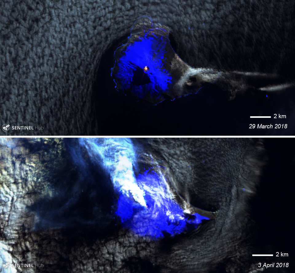 |
Figure 15. Hotspots in Sentinel-2 imagery on 29 March and 3 April 2018 indicated eruptive activity at Mount Michael on Saunders Island. Sentinel-2 image with Atmospheric Penetration view (bands 12, 11, and 8A), courtesy of Sentinel Hub Playground. |
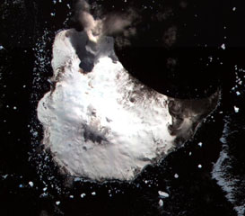
MIROVA thermal signals appeared in mid-July and mid-August 2018 (figure 13) but little satellite imagery was available to confirm any thermal activity. The next clear signal of eruptive activity was evident in a Sentinel-2 image as a hotspot at the summit on 23 September. A small MIROVA signal was recorded the same day (figure 13, bottom). A few days later, on 28 September 2018, a Landsat 8 image showed a clear streak of dark-gray ash trending NW from the summit of Mount Michael (figure 16).
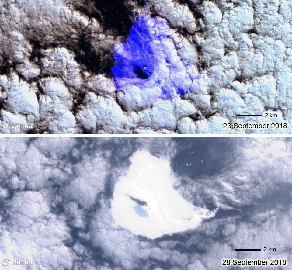 |
Figure 16. Satellite imagery confirmed eruptive activity at Mount Michael on Saunders Island in late September 2018. Top: a hotpot in a Sentinel-2 image on 23 September coincided with a MIROVA thermal signal (see figure 13); Bottom: A Landsat 8 image on 28 September has a distinct dark gray streak trending NW from the summit indicating a fresh ash deposit. The lighter gray area SW of the summit is likely a shadow. Sentinel-2 image with Atmospheric Penetration view, (bands 12, 11, and 8A), Landsat 8 image with pansharpened image processing, both courtesy of Sentinel Hub Playground. |
Geological Summary. Saunders Island consists of a large central volcanic edifice intersected by two seamount chains, as shown by bathymetric mapping (Leat et al., 2013). The young Mount Michael stratovolcano dominates the glacier-covered island, while two submarine plateaus, Harpers Bank and Saunders Bank, extend north. The symmetrical Michael has a 500-m-wide summit crater and a remnant of a somma rim to the SE. Tephra layers visible in ice cliffs surrounding the island are evidence of recent eruptions. Ash clouds were reported from the summit crater in 1819, and an effusive eruption was inferred to have occurred from a N-flank fissure around the end of the 19th century and beginning of the 20th century. A low ice-free lava platform, Blackstone Plain, is located on the north coast, surrounding a group of former sea stacks. A cluster of cones on the SE flank, the Ashen Hills, appear to have been modified since 1820 (LeMasurier and Thomson, 1990). Analysis of satellite imagery available since 1989 (Gray et al., 2019; MODVOLC) suggests frequent eruptive activity (when weather conditions allow), volcanic clouds, steam plumes, and thermal anomalies indicative of a persistent, or at least frequently active, lava lake in the summit crater. Due to this observational bias, there has been a presumption when defining eruptive periods that activity has been ongoing unless there is no evidence for at least 10 months.
Information Contacts: Hawai'i Institute of Geophysics and Planetology (HIGP) - MODVOLC Thermal Alerts System, School of Ocean and Earth Science and Technology (SOEST), Univ. of Hawai'i, 2525 Correa Road, Honolulu, HI 96822, USA (URL: http://modis.higp.hawaii.edu/); MIROVA (Middle InfraRed Observation of Volcanic Activity), a collaborative project between the Universities of Turin and Florence (Italy) supported by the Centre for Volcanic Risk of the Italian Civil Protection Department (URL: http://www.mirovaweb.it/); Sentinel Hub Playground, (URL: https://www.sentinel-hub.com/explore/sentinel-playground); NASA Worldview (URL: https://worldview.earthdata.nasa.gov/).