Report on Ibu (Indonesia) — December 2018

Bulletin of the Global Volcanism Network, vol. 43, no. 12 (December 2018)
Managing Editor: Edward Venzke.
Research and preparation by Paul Berger.
Ibu (Indonesia) Thermal anomalies and ash explosions from the crater continue during May-November 2018
Please cite this report as:
Global Volcanism Program, 2018. Report on Ibu (Indonesia) (Venzke, E., ed.). Bulletin of the Global Volcanism Network, 43:12. Smithsonian Institution. https://doi.org/10.5479/si.GVP.BGVN201812-268030
Ibu
Indonesia
1.488°N, 127.63°E; summit elev. 1325 m
All times are local (unless otherwise noted)
Continuing activity at Ibu has consisted of numerous thermal anomalies and, except apparently for the period from September 2017 through early March 2018, intermittent ash explosions (BGVN 43:05). This activity continued through November 2018. The Alert Level has remained at 2 (on a scale of 1-4), and the public was warned to stay at least 2 km away from the active crater, and 3.5 km away on the N side.
Ash plumes were seen frequently during May-November 2018 (table 4). Plume heights above the crater were generally 400-80 m. However, ash plumes on 28 and 29 July rose 5.5 and 4.8 km, respectively. Seismicity associated with ash plumes were characterized by explosion and avalanche signals.
Table 4. Ash explosions reported at Ibu, May-November 2018. Data courtesy of PVMBG and Darwin VAAC.
| Date | Time | Ash plume (height above crater rim) | Plume Drift |
| 05 May 2018 | 0622 | 600 m | N, NE |
| 06 Jun 2018 | 1206 | 500 m | N |
| 12 Jun 2018 | 1750 | 600 m | N |
| 14-19 Jun 2018 | -- | 200-600 m | N |
| 21 Jun 2018 | 0857 | 600 m | N |
| 22-26 Jun 2018 | -- | 850 m | WNW, W |
| 27 Jun 2018 | -- | 500 m | W |
| 06 Jul 2018 | -- | 800 m | N |
| 10-15 Jul 2018 | -- | 200-800 m | -- |
| 28 Jul 2018 | 1852 | 5.5 km | SE |
| 29 Jul 2018 | 1612 | 4.8 km | N, SE |
| 13 Aug 2018 | 0259 | 600 m | -- |
| 20 Aug 2018 | 1742 | 1.2 km | -- |
| 24 Aug 2018 | 0838 | 800 m | S |
| 28, 30 Sep 2018 | -- | 500 m | N, NE |
| 06 Oct 2018 | -- | 500 m | WSW |
| 19 Oct 2018 | 1223 | 400 m | N |
| 26 Nov 2018 | -- | 500 m | SE |
The number of thermal anomalies during this time, based on MODIS satellite instruments analyzed using the MODVOLC algorithm, ranged from 2 days/month (July) to 9 days/month (September); some events were two pixels. Days with anomalies and ash explosions were not well correlated. The MIROVA (Middle InfraRed Observation of Volcanic Activity) volcano hotspot detection system, also based on analysis of MODIS data, detected numerous hotspots every month of the reporting period, almost all of which were within 5 km of the volcano and of low-to-moderate power. Infrared satellite imagery showed that the volcano had at least two, and sometimes three, active dome or vent locations (figure 14).
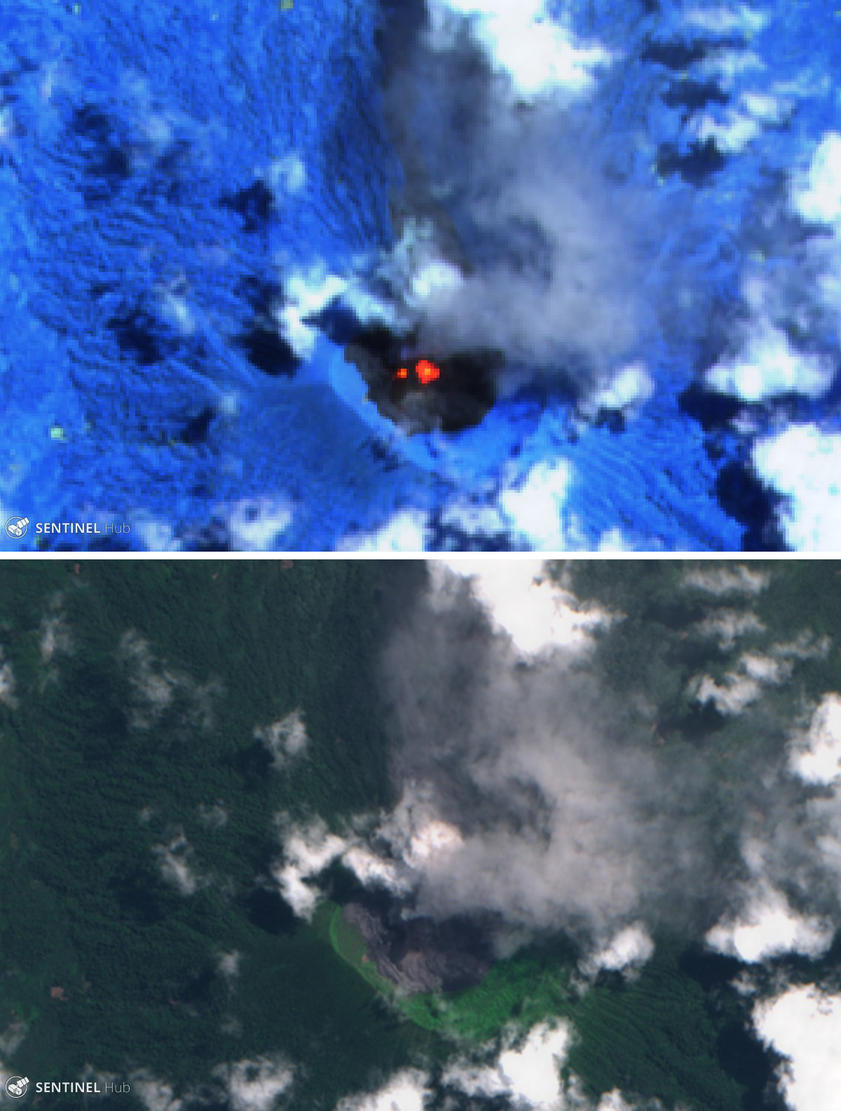 |
Figure 14. Sentinel-2 satellite images of Ibu on 19 August 2018. Top image (infrared, bands 12, 11, 8A) shows a large central hotspot and a smaller thermal area immediately to the west. Bottom image (natural color, bands 8, 4, 3) shows both an ash plume (gray) and steam plume (white), along with fresh and older lava in the crater. Courtesy of Sentinel Hub Playground. |
Geological Summary. The truncated summit of Gunung Ibu stratovolcano along the NW coast of Halmahera Island has large nested summit craters. The inner crater, 1 km wide and 400 m deep, has contained several small crater lakes. The 1.2-km-wide outer crater is breached on the N, creating a steep-walled valley. A large cone grew ENE of the summit, and a smaller one to the WSW has fed a lava flow down the W flank. A group of maars is located below the N and W flanks. The first observed and recorded eruption was a small explosion from the summit crater in 1911. Eruptive activity began again in December 1998, producing a lava dome that eventually covered much of the floor of the inner summit crater along with ongoing explosive ash emissions.
Information Contacts: Pusat Vulkanologi dan Mitigasi Bencana Geologi (PVMBG, also known as Indonesian Center for Volcanology and Geological Hazard Mitigation, CVGHM), Jalan Diponegoro 57, Bandung 40122, Indonesia (URL: http://www.vsi.esdm.go.id/); Darwin Volcanic Ash Advisory Centre (VAAC), Bureau of Meteorology, Northern Territory Regional Office, PO Box 40050, Casuarina, NT 0811, Australia (URL: http://www.bom.gov.au/info/vaac/); Hawai'i Institute of Geophysics and Planetology (HIGP) - MODVOLC Thermal Alerts System, School of Ocean and Earth Science and Technology (SOEST), Univ. of Hawai'i, 2525 Correa Road, Honolulu, HI 96822, USA (URL: http://modis.higp.hawaii.edu/); MIROVA (Middle InfraRed Observation of Volcanic Activity), a collaborative project between the Universities of Turin and Florence (Italy) supported by the Centre for Volcanic Risk of the Italian Civil Protection Department (URL: http://www.mirovaweb.it/); Sentinel Hub Playground (URL: https://www.sentinel-hub.com/explore/sentinel-playground).