Report on Ebeko (Russia) — December 2018
Bulletin of the Global Volcanism Network, vol. 43, no. 12 (December 2018)
Managing Editor: Edward Venzke.
Research and preparation by Paul Berger.
Ebeko (Russia) Frequent ash explosions continue during June-November 2018
Please cite this report as:
Global Volcanism Program, 2018. Report on Ebeko (Russia) (Venzke, E., ed.). Bulletin of the Global Volcanism Network, 43:12. Smithsonian Institution. https://doi.org/10.5479/si.GVP.BGVN201812-290380
Ebeko
Russia
50.686°N, 156.014°E; summit elev. 1103 m
All times are local (unless otherwise noted)
Typical activity during the current eruption at Ebeko that began in October 2016 consists of numerous explosions and associated ash plumes (BGVN 43:06). The Kamchatkan Volcanic Eruption Response Team (KVERT) is responsible for monitoring this remote volcano, and has an observation site at Severo-Kurilsk, 7 km E. The current report reviews events from June through November 2018. During the reporting period, the Aviation Color Code remained at Orange, the second highest level of the four-color scale.
According to KVERT, numerous moderate explosions every month generated ash plumes (figure 18 an d19) that rose between 2.5-6 km in altitude, with most between 3 and 4.5 km (table 7). Occasionally, ashfall was reported in Severo-Kurilsk. KVERT reported that thermal anomalies began about mid-August and continued through November.
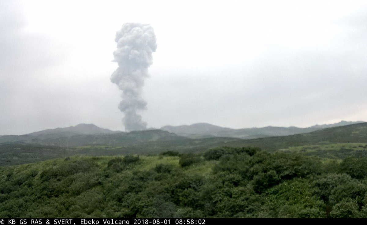 |
Figure 18. Ash explosion at Ebeko on 1 August 2018. Image from video by SVERT (IMGG FEB RAS) and KB GS RAS, courtesy of Institute of Volcanology and Seismology FEB RAS, KVERT. |
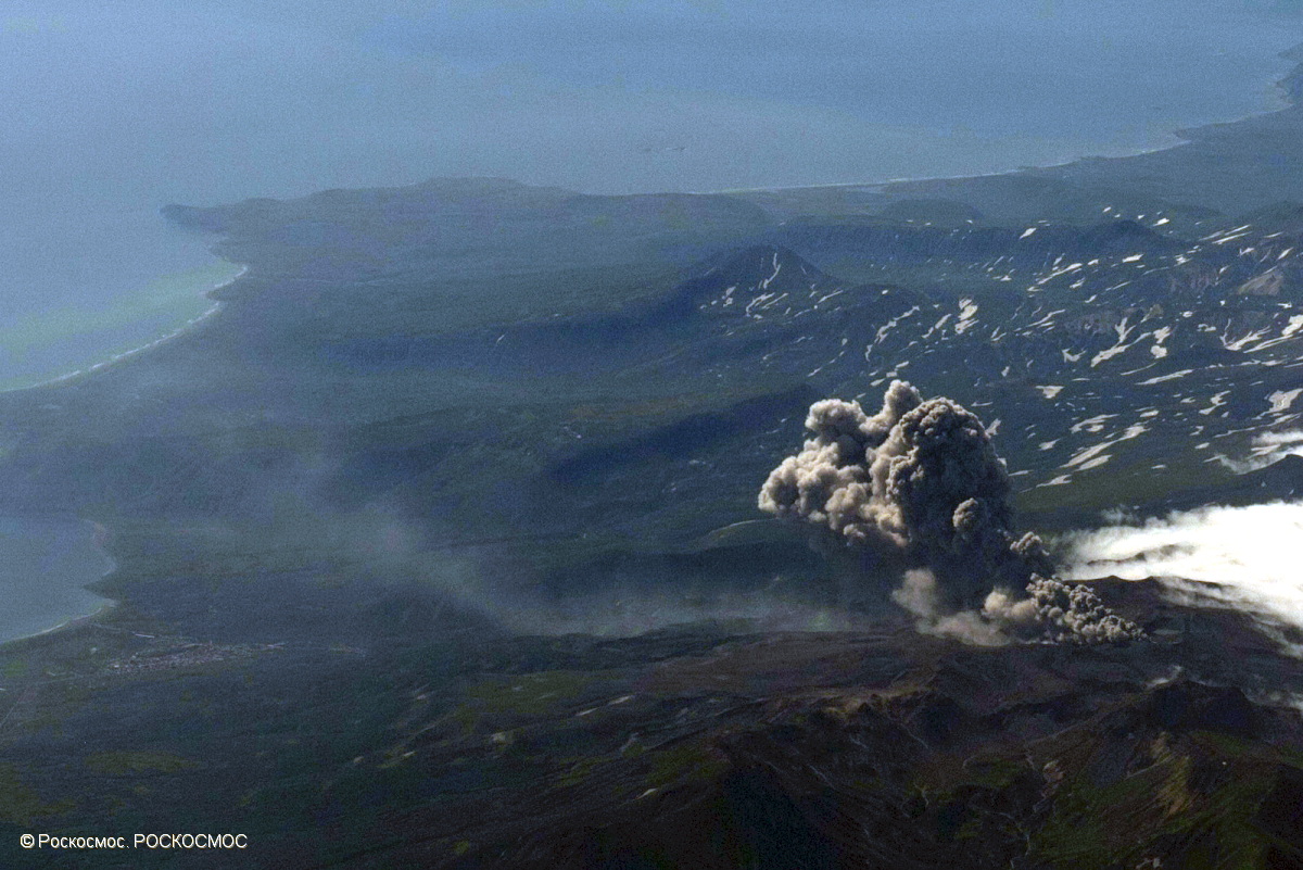 |
Figure 19. Aerial photo showing an explosive eruption of Ebeko at 2322 UTC on 21 August 2018. Photo by Roskosmos (color corrected), courtesy of Institute of Volcanology and Seismology FEB RAS, KVERT. |
Table 7. Summary of activity at Ebeko from June-November 2018. TA is thermal anomaly, S-K is Severo-Kurilsk (7 km E of the volcano). Data courtesy of KVERT.
| Date | Plume Altitude | Plume Distance | Plume Direction | Other observations |
| 05 Jun 2018 | -- | 8 km | E | Diffuse ash plume. |
| 15 Jun 2018 | -- | 14 km | SE | -- |
| 17-18 Jun 2018 | 2.5-3 km | -- | -- | Explosions. |
| 26-27 Jun 2018 | 3 km | -- | -- | Explosions. |
| 30 Jun-01 Jul 2018 | 3.2 km | 57 km | SE | Explosions. |
| 08-12 Jul 2018 | 4 km | 37 km | W | Explosions. |
| 13-20 Jul 2018 | 3.4 km | -- | -- | Explosions. |
| 20-21, 25-26 Jul 2018 | 4 km | 15 km | E | Explosions. |
| 29 Jul-01 Aug 2018 | 6 km | -- | -- | Explosions. |
| 03-10 Aug 2018 | 3.7 km | 65 km | E | Explosions. |
| 11-17 Aug 2018 | 4.5 km | 52 km | SE | Explosions. TA on 12 Aug. |
| 17-24 Aug 2018 | 5.2 km | 235 km | SE | Explosions. TA on 21-23 Aug. |
| 24-31 Aug 2018 | 3.6 km | 135 km | SE, S, SW | Explosions. TA 24-25, 30 Aug. Ashfall on 29-30 Aug. |
| 31 Aug-07 Sep 2018 | 4.5 km | 75 km | N, S | Explosions. TA on 4-5 Sep. |
| 07-13 Sep 2018 | 3.4 km | 113 km | SE, NE | Explosions. TA on 7, 9, 12-13 Sep. Occasional incandescence on 10-13 Sep. |
| 14-21 Sep 2018 | 4.2 km | 80 km | E | Explosions. TA occasionally visible. |
| 21-28 Sep 2018 | 4 km | 68 km | SE | Explosions. TA on 23, 27 Sep. |
| 28 Sep-05 Oct 2018 | 4.5 km | 80 km | SW, SE, E | Explosions. TA on 27-28 Sep. |
| 05-12 Oct 2018 | 4.5 km | 125 km | SE | Explosions. TA on 8 Oct. |
| 12-19 Oct 2018 | 4.5 km | Multiple | Explosions. Ashfall in S-K. | |
| 19-26 Oct 2018 | 4.7 km | 80 km | E | Explosions. TA on 24 Oct. Ashfall in S-K. |
| 26 Oct-02 Nov 2018 | 3.7 km | -- | Multiple | Explosions. TA on 24, 29 Oct. Ashfall in S-K on 29-31 Oct. |
| 02-09 Nov 2018 | 3.7 km | -- | Multiple | Explosions. Ashfall in S-K. |
| 09-15 Nov 2018 | 4.5 km | -- | E | Explosions. Weak TA on 12-13 Nov. |
| 15-23 Nov 2018 | 3.2 km | -- | NE, S | Explosions. |
| 23-30 Nov 2018 | 4 km | -- | E | Explosions. Weak TA on 24 Nov. Ashfall in S-K on 27, 29 Nov. |
Thermal anomalies, based on MODIS satellite instruments analyzed using the MODVOLC algorithm, were observed only twice during the reporting period, on 30 August and 29 September 2018. The MIROVA (Middle InfraRed Observation of Volcanic Activity) volcano hotspot detection system, also based on analysis of MODIS data, detected a few scattered anomalies, almost all of which were concentrated during the latter half of August through September. These data are consistent with KVERT's observations of thermal anomalies beginning in mid-August.
Geological Summary. The flat-topped summit of the central cone of Ebeko volcano, one of the most active in the Kuril Islands, occupies the northern end of Paramushir Island. Three summit craters located along a SSW-NNE line form Ebeko volcano proper, at the northern end of a complex of five volcanic cones. Blocky lava flows extend west from Ebeko and SE from the neighboring Nezametnyi cone. The eastern part of the southern crater contains strong solfataras and a large boiling spring. The central crater is filled by a lake about 20 m deep whose shores are lined with steaming solfataras; the northern crater lies across a narrow, low barrier from the central crater and contains a small, cold crescentic lake. Historical activity, recorded since the late-18th century, has been restricted to small-to-moderate explosive eruptions from the summit craters. Intense fumarolic activity occurs in the summit craters, on the outer flanks of the cone, and in lateral explosion craters.
Information Contacts: Kamchatka Volcanic Eruptions Response Team (KVERT), Far Eastern Branch, Russian Academy of Sciences, 9 Piip Blvd., Petropavlovsk-Kamchatsky, 683006, Russia (URL: http://www.kscnet.ru/ivs/kvert/); Institute of Volcanology and Seismology, Far Eastern Branch, Russian Academy of Sciences (IVS FEB RAS), 9 Piip Blvd., Petropavlovsk-Kamchatsky 683006, Russia (URL: http://www.kscnet.ru/ivs/eng/); Hawai'i Institute of Geophysics and Planetology (HIGP) - MODVOLC Thermal Alerts System, School of Ocean and Earth Science and Technology (SOEST), Univ. of Hawai'i, 2525 Correa Road, Honolulu, HI 96822, USA (URL: http://modis.higp.hawaii.edu/); MIROVA (Middle InfraRed Observation of Volcanic Activity), a collaborative project between the Universities of Turin and Florence (Italy) supported by the Centre for Volcanic Risk of the Italian Civil Protection Department (URL: http://www.mirovaweb.it/).