Report on Ambrym (Vanuatu) — January 2019
Bulletin of the Global Volcanism Network, vol. 44, no. 1 (January 2019)
Managing Editor: Edward Venzke.
Edited by Janine B. Krippner.
Ambrym (Vanuatu) Fissure eruption in mid-December 2018 produces fountaining and lava flows; no activity evident in caldera after 17 December
Please cite this report as:
Global Volcanism Program, 2019. Report on Ambrym (Vanuatu) (Krippner, J.B., and Venzke, E., eds.). Bulletin of the Global Volcanism Network, 44:1. Smithsonian Institution. https://doi.org/10.5479/si.GVP.BGVN201901-257040
Ambrym
Vanuatu
16.25°S, 168.12°E; summit elev. 1334 m
All times are local (unless otherwise noted)
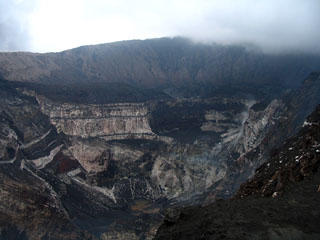
Ambrym is a shield volcano in the Vanuatu archipelago with a 12-km-wide summit caldera containing the persistently active Benbow and Marum craters. These craters are home to multiple active vents that produce episodic lava lakes, explosions, lava flows, ash, and gas emissions. Occasional fissure eruptions occur outside of these main craters. This report covers July to December 2018 and summarizes reports by the Vanuatu Meteorology and Geohazards Department (VMGD), the Wellington Volcanic Ash Advisory Center (VAAC), and multiple sources of satellite data.
As of the beginning of the reporting period, the hazard status at Ambrym had remained at Volcanic Alert Level 2 ("Major unrest") since 7 December 2017. Monthly VMGD activity reports describe the continued activity within the two main craters, consisting of multiple lava lakes, sustained substantial degassing and steam emission, and seismic unrest. Frequent thermal anomalies were detected throughout the reporting period (figure 42). The danger areas were confined to the Permanent Exclusion Zone within a 1 km radius of Benbow crater, and the Permanent Exclusion Zone and Danger Zone A within about a 2.7 km radius of Marum crater (including Maben-Mbwelesu, Niri-Mbwelesu and Mbwelesu, see BGVN 43:07, figure 38).
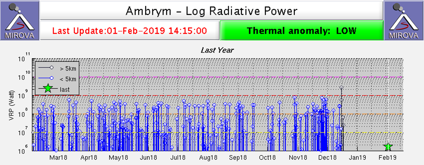 |
Figure 42. Plot of MODIS thermal infrared data analyzed by MIROVA showing the log radiative power of thermal anomalies at Ambrym for the year ending on 1 February 2019. After the December 2018 eruption no further thermal anomalies were noted for the reporting period. Courtesy of MIROVA. |
Observations and seismic data analysis by VMGD confirmed the onset of a small-scale intra-caldera fissure eruption at 0600 local time on 15 December. This new fissure produced lava fountains and lava flows with ash and gas plumes (figure 43). Footage of the eruption by John Tasso shows the fissure eruption to the SE of Marum crater producing lava fountaining. A Sentinel-2 satellite image shows a white eruption plume and two new lava flow lobes (figure 44); the actual fissure vent was hidden by the plume. The northernmost lava flow filled in the 500 x 900 m Lewolembwi crater and a smaller lobe continued to flow towards the E (figure 44). Due to this elevated activity, the Volcanic Alert Level was raised to 3 ("Minor eruption"), with the danger zones increased to a 2 km radius around Benbow crater and a 4 km radius around Marum crater. VMGD warned of additional risk within 3 km of eruptive fissures in the SE caldera area.
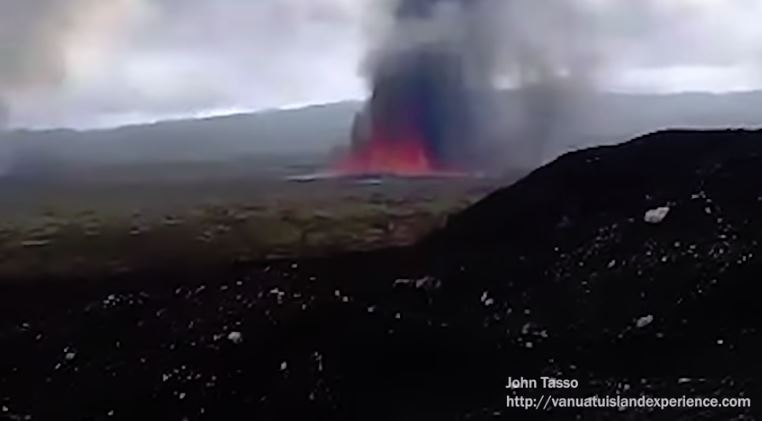 |
Figure 43. Image of the fissure eruption producing lava fountaining at Ambrym volcano, taken from a video recorded by John Tasso on 16 December 2018. |
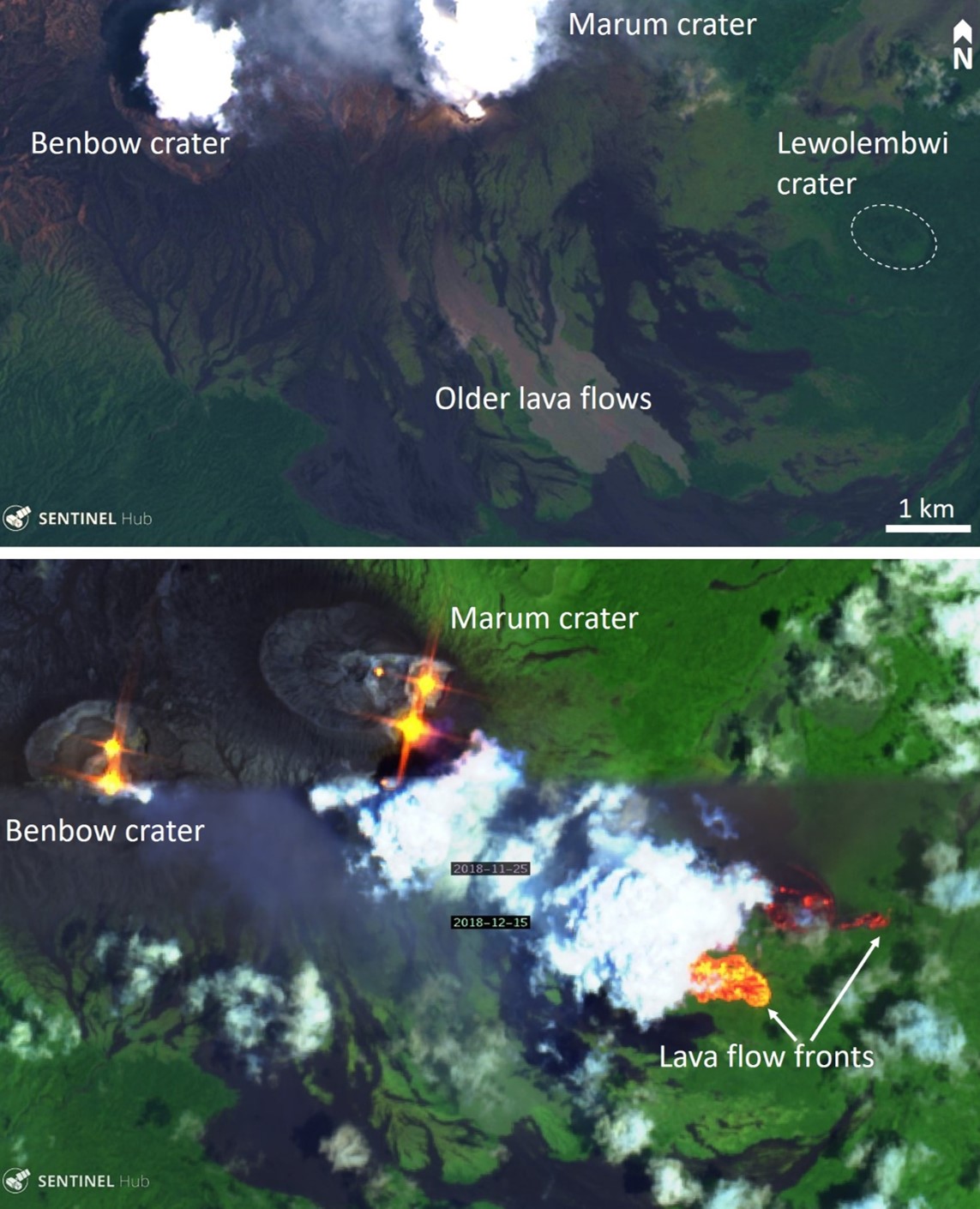 |
Figure 44. Satellite imagery showing the Ambrym caldera area in November-December 2018. Top: True color Landsat-8 satellite image acquired on 13 December 2018 showing the area prior to the fissure eruption. Bottom: False-color infrared Sentinel-2 composite image (bands 12, 11, and 4) showing the multiple active vents and lava lakes within Marum and Benbow craters (top third of the image, acquired on 25 November 2018), and the eruption plume and the bright orange/red lava flow fronts in the bottom of the image (acquired on 15 December 2018); the fissure is obscured by the plume. Courtesy of Sentinel-Hub Playground. |
Through 16-17 December, ash and gas emission continued from Benbow and Marum craters (figures 45 and 46), accompanied by ongoing localized seismicity; earthquakes with a magnitude greater than five were felt on neighboring islands. The Wellington VAAC issued ash advisories on 16 and 17 December noting maximum cloud altitudes of approximately 8 km.
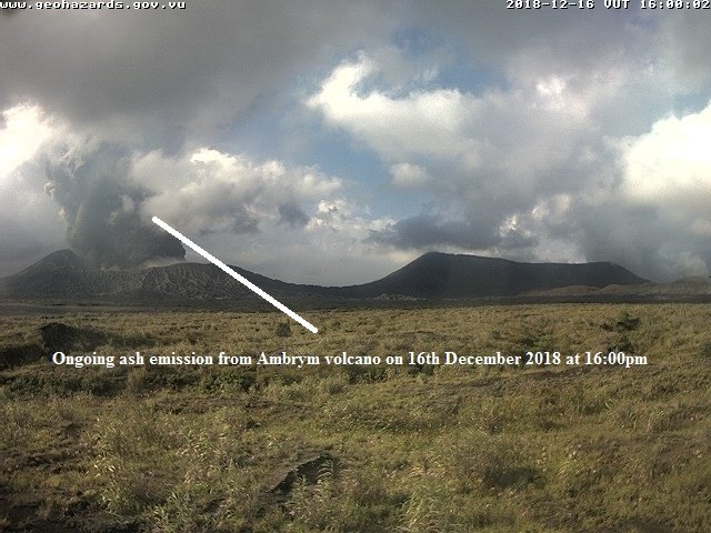 |
Figure 45. Ash emission from Ambrym volcano at 1600 on 16 December 2018. Webcam image courtesy of, and annotated by, VMGD. |
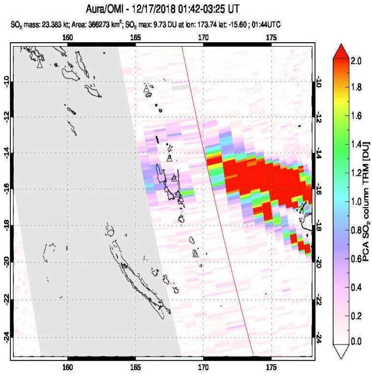 |
Figure 46. Elevated atmospheric SO2 emissions from Ambrym on 17 December 2018 with a total measured mass of 23.383 kt in this scene. The units on the scale bar reflect SO2 in terms of Dobson Units (DU). Courtesy of the NASA Goddard Flight Center Atmospheric Chemistry and Dynamics Laboratory. |
From 14 to 26 December, the National Volcano Monitoring Network detected over 4,500 earthquakes related to the eruptive activity, but locally felt seismicity decreased. Analysis of satellite imagery confirmed surface deformation associated with the increase in activity. Media reports from Radio New Zealand indicated that seismic activity during December resulted in ground rupture and damage to homes on the island and residents were moved to evacuation centers.
During the reporting period, thermal anomalies were frequently detected by the MODIS satellite instruments and subsequently analyzed using the MODVOLC algorithm, reflecting the lava lake activity in Benbow and Marum craters, as well additional thermal anomalies during the December 2018 fissure eruption and subsequent lava flows to the SE of the main crater area (figures 47 and 48).
 |
Figure 47. MODVOLC Thermal Alert System from July through December 2018 showing the two active craters of Ambrym, Benbow and Marum, and the December 2018 fissure eruption. Red areas indicate approximate locations of Thermal Anomaly detections along with the number of detections. Courtesy of HIGP - MODVOLC Thermal Alerts System. |
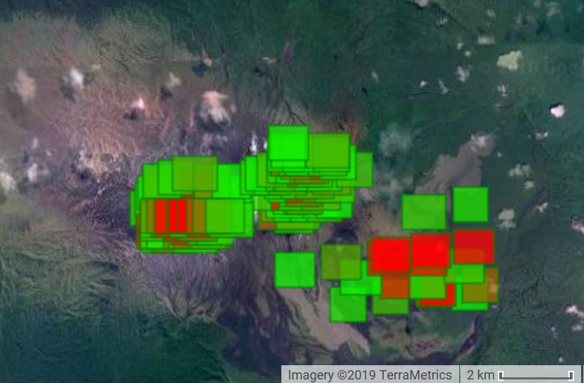 |
Figure 48. MODVOLC thermal alerts detected over Ambrym volcano during July 2018 through December 2018 showing hot spots located at Benbow and Marum craters and the December 2018 fissure eruption. Courtesy of HIGP - MODVOLC Thermal Alerts System. |
As of 7 January 2019, Ambrym remains on Alert Level 3 with continued seismic activity. The MIROVA (Middle InfraRed Observation of Volcanic Activity) system has not detected any recent thermal anomalies, indicating the end of the fissure eruption and a reduction in activity at the main craters.
Geological Summary. Ambrym, a large basaltic volcano with a 12-km-wide caldera, is one of the most active volcanoes of the New Hebrides Arc. A thick, almost exclusively pyroclastic sequence, initially dacitic then basaltic, overlies lava flows of a pre-caldera shield volcano. The caldera was formed during a major Plinian eruption with dacitic pyroclastic flows about 1,900 years ago. Post-caldera eruptions, primarily from Marum and Benbow cones, have partially filled the caldera floor and produced lava flows that ponded on the floor or overflowed through gaps in the caldera rim. Post-caldera eruptions have also formed a series of scoria cones and maars along a fissure system oriented ENE-WSW. Eruptions have apparently occurred almost yearly during historical time from cones within the caldera or from flank vents. However, from 1850 to 1950, reporting was mostly limited to extra-caldera eruptions that would have affected local populations.
Information Contacts: Geo-Hazards Division, Vanuatu Meteorology and Geo-Hazards Department (VMGD), Ministry of Climate Change Adaptation, Meteorology, Geo-Hazards, Energy, Environment and Disaster Management, Private Mail Bag 9054, Lini Highway, Port Vila, Vanuatu (URL: http://www.vmgd.gov.vu/, https://www.facebook.com/VanuatuGeohazardsObservatory/); Hawai'i Institute of Geophysics and Planetology (HIGP) - MODVOLC Thermal Alerts System, School of Ocean and Earth Science and Technology (SOEST), Univ. of Hawai'i, 2525 Correa Road, Honolulu, HI 96822, USA (URL: http://modis.higp.hawaii.edu/); MIROVA (Middle InfraRed Observation of Volcanic Activity), a collaborative project between the Universities of Turin and Florence (Italy) supported by the Centre for Volcanic Risk of the Italian Civil Protection Department (URL: http://www.mirovaweb.it/); NASA Goddard Space Flight Center (NASA/GSFC), Global Sulfur Dioxide Monitoring Page, Atmospheric Chemistry and Dynamics Laboratory, 8800 Greenbelt Road, Goddard, Maryland, USA (URL: https://so2.gsfc.nasa.gov/); Radio New Zealand, 155 The Terrace, Wellington 6011, New Zealand (URL: https://www.radionz.co.nz/); Sentinel Hub Playground (URL: https://www.sentinel-hub.com/explore/sentinel-playground); John Tasso, Vanuatu Island Experience, Port Vatu, West Ambrym, Vanuatu (URL: http://vanuatuislandexperience.com/).