Kilauea
United States
19.421°N, 155.287°W; summit elev. 1222 m
All times are local (unless otherwise noted)
Kīlauea's East Rift Zone (ERZ) has been intermittently active for at least two thousand years. Since the current eruptive period began in 1983 there have been open lava lakes and flows from the summit caldera and the East Rift Zone. A marked increase in seismicity and ground deformation at Pu'u 'O'o Cone on the upper East Rift Zone on 30 April 2018, and the subsequent collapse of its crater floor, marked the beginning of the largest lower East Rift Zone eruptive episode in at least 200 years; the ending of this episode in early September 2018 marked the end of 36 years of continuous activity.
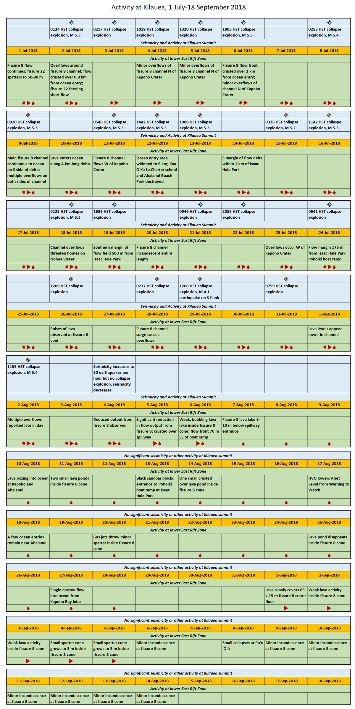
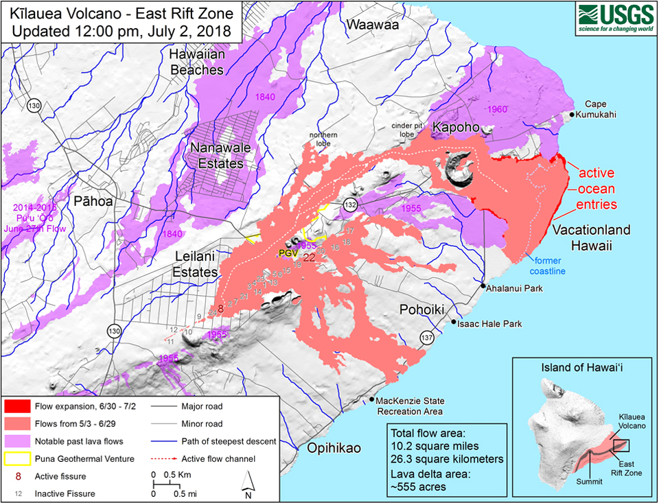
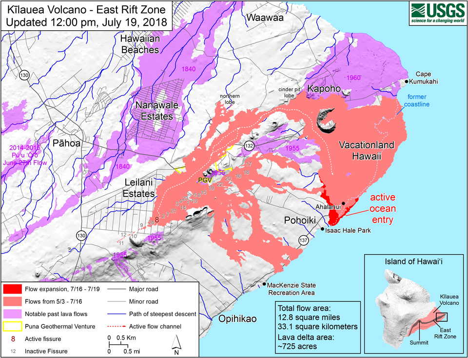
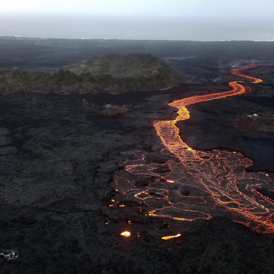
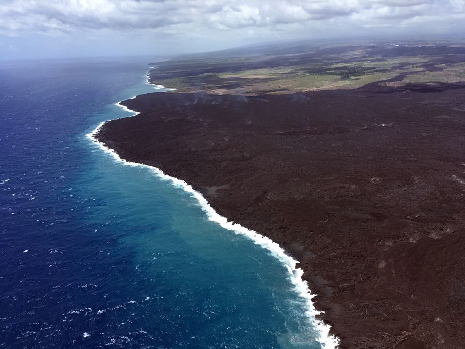
During May 2018, lava moving into the Lower East Rift Zone opened 24 fissures along a 6-km-long NE-trending fracture zone, sending lava flows in multiple directions. As lava emerged from the fissures, the lava lake at Halema'uma'u drained and explosions sent ash plumes to several kilometer's altitude (BGVN 43:10). At the end of May, eruptive activity focused on 60-m-high fountains of lava from fissure 8 that created a rapidly moving flow that progressed 13 km in just five days, entering the ocean at Kapoho Bay and destroying over 500 homes. Throughout June vigorous effusion from fissure 8 created a 50-m-tall cone and a massive lava channel that carried lava to a growing 3-km-wide delta area which spread out into the ocean along the coast (BGVN 43:12). At Halema'uma'u crater, regular collapse explosion events were the response of the crater to the subsidence caused by the magma withdrawal on the lower East Rift Zone. The deepest part of the crater had reached 400 m below the caldera floor by late June. The eruptive events of July-September 2018 (figure 424), the last three months of this episode, are described in this report with information provided primarily from the US Geological Survey's (USGS) Hawaiian Volcano Observatory (HVO) in the form of daily reports, volcanic activity notices, and abundant photo, map, and video data.
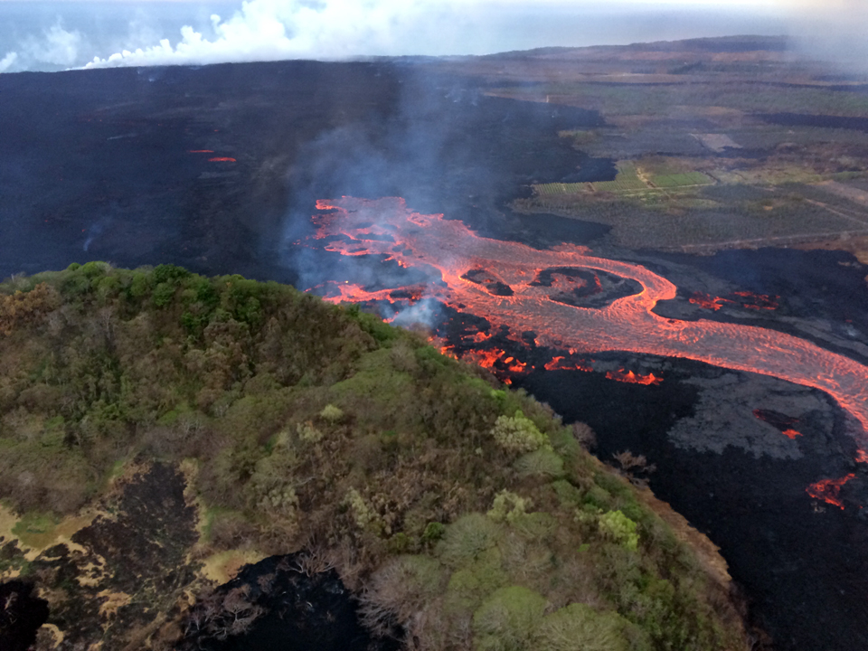
Summary of activity, July-September 2018. The lava flow emerging from the fissure 8 cone on the Lower East Rift Zone continued unabated throughout July 2018. Overflows from the open channel were common, and often occurred a few hours after summit collapse events. There were multiple active ocean entry areas along the north, central, and southern portions of the coastal flow front of the fissure 8 flow at various times throughout the month. As the flow approached the delta area, lava spread out over the flow field and was no longer flowing on the surface but continued on the interior of the delta; numerous ocean entry points spanned the growing delta. In mid-July, an overflow diverted the channel W of Kapoho Crater, causing a new channel to the S of the delta that destroyed a park and a school, and increased the width of the delta to 6 km. The near-daily collapse events at Halema'uma'u crater continued until 2 August, transforming the geomorphology of the summit caldera.
Lower lava levels at the fissure 8 channel flow were first reported in early August; a reduced output from the cone was reported on 4 August and the lava level in the cone fell below the spillway the next day, shutting off the lava supply to the channel. The lava channel drained and crusted over during the next few days, but lava continued to enter the ocean at a decreasing rate for the rest of the month; the last ocean entry point had ceased by 29 August. A minor burst of spatter from gas jets inside the cone was noted on 20 August. The last activity was a small flow that covered the floor of the fissure 8 cone and created a small spatter cone during 1-5 September. Incandescence at the crater subsided during the next week until only steam activity was reported on the Lower East Rift Zone by the second half of September 2018.
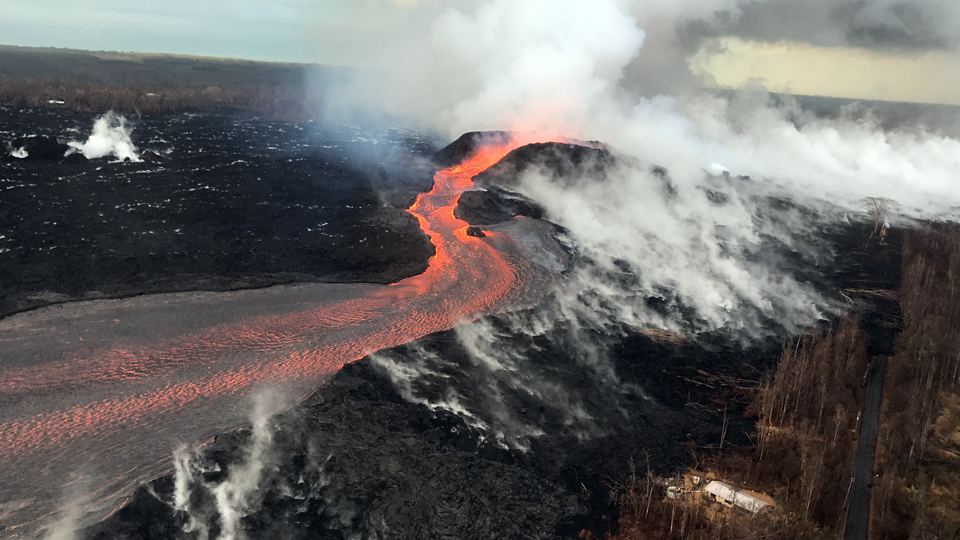
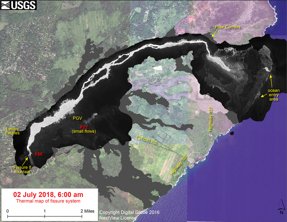
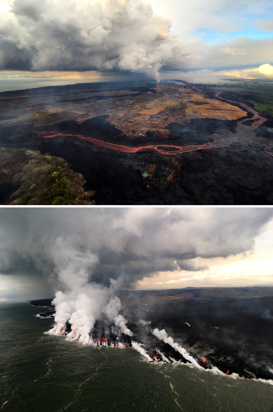
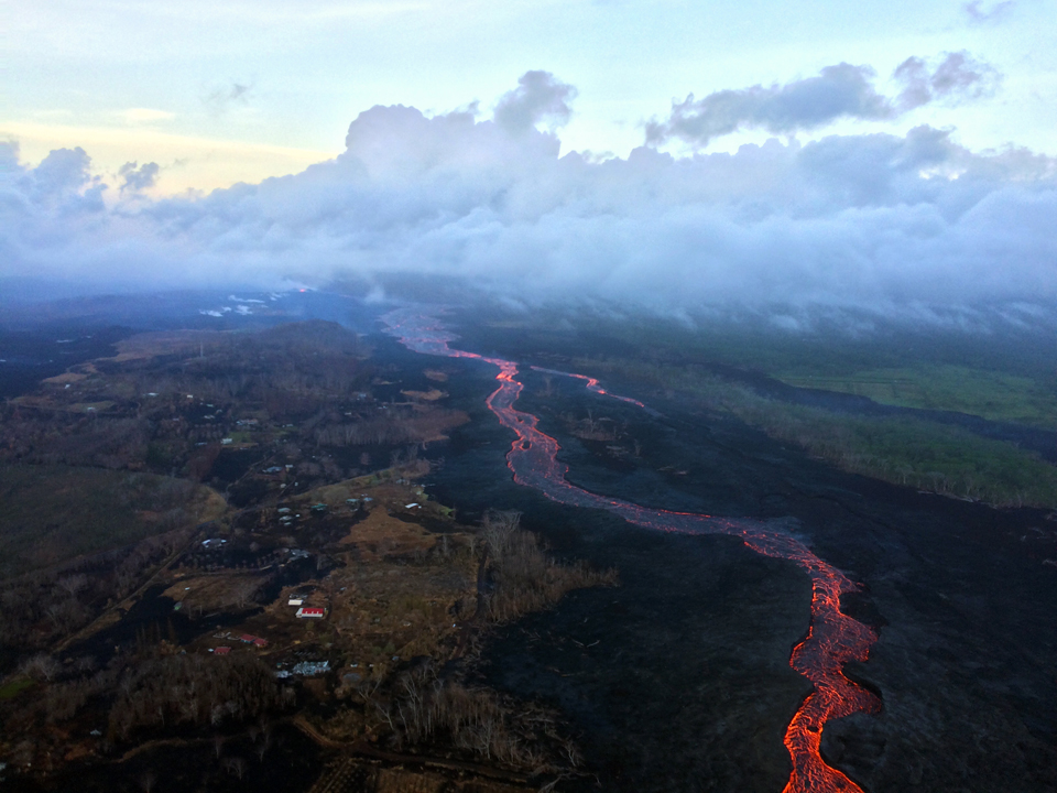
Activity on the Lower East Rift Zone during 1-12 July 2018. The lava flow emerging from the fissure 8 cone on the Lower East Rift Zone continued unabated during July 2018 (figure 425). Overflows from the open channel were common, sending multiple short streams of lava down the built-up flanks of the channel (figure 426). The fissure 8 lava flow was the most significant activity at the Lower East Rift Zone during July 2018, but it was not the only activity observed by HVO scientists. Fissure 22 was also spattering tephra 50-80 m above a small spatter cone and feeding a short lava flow that was moving slowly NE along the edge of earlier flows during 1-11 July (figures 427 and 428). There were multiple active ocean entry areas along the north, central, and southern portions of the coastal flow front of the fissure 8 flow at various times throughout the month.
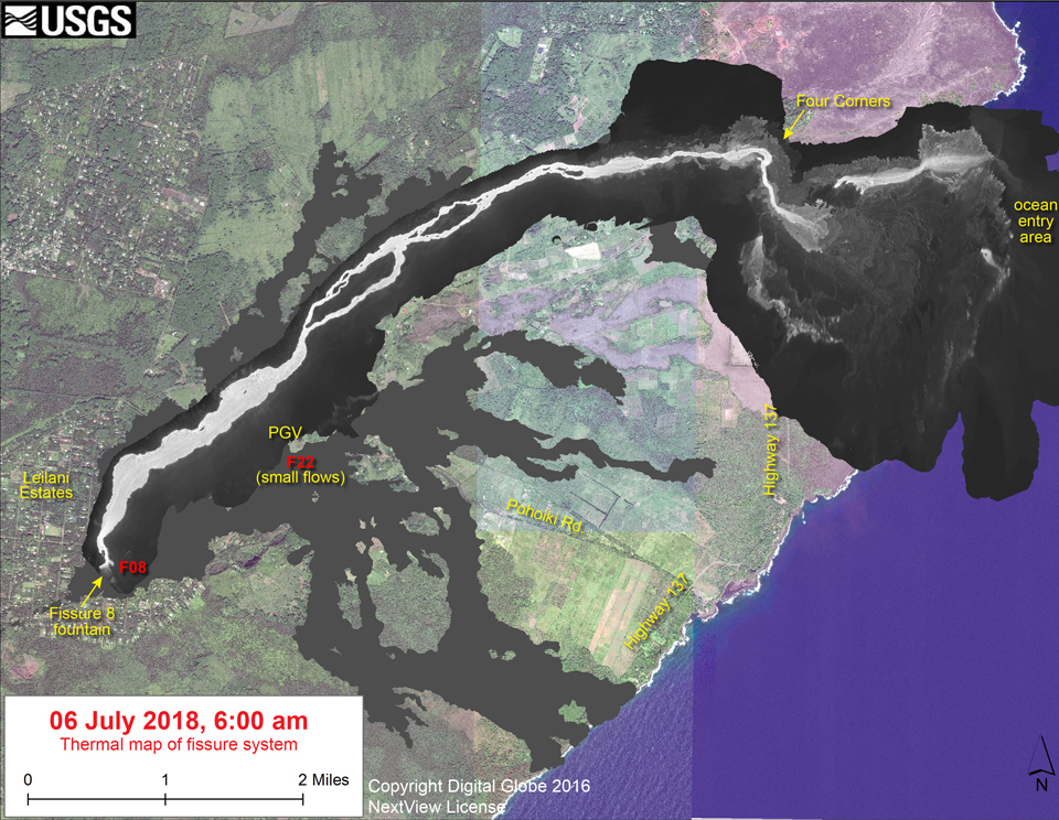
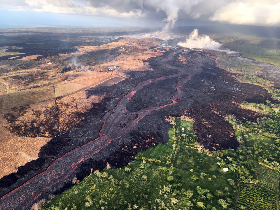
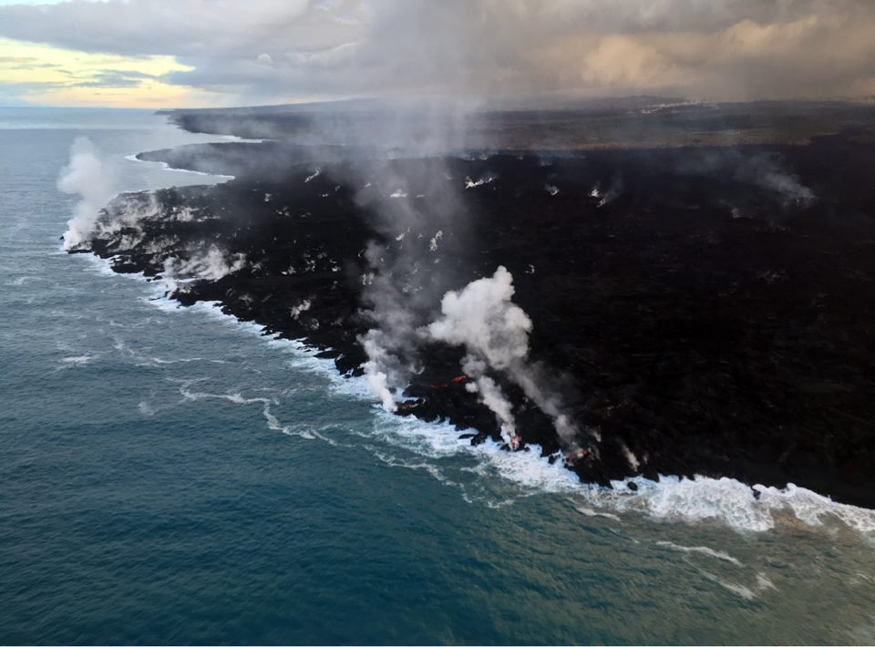
The lava channel had begun crusting over near the coast late in June, and the lava was streaming from the flow's molten interior into the ocean at many points along its broad front during the first half of July. The crusted-over area was 0.8 km from the coast on 2 July and had increased to 2 km from the coast on 6 July (figure 429). Temporary channel blockages of the flow caused minor overflows north of Kapoho Crater during 4-6 July. Multiple breakouts fed flows on the N and the SW edge of the main `a`a flow. HVO captured images during an overflight on 8 July of the area where the open channel ended and turned into the broad flow area of the delta (figure 430).
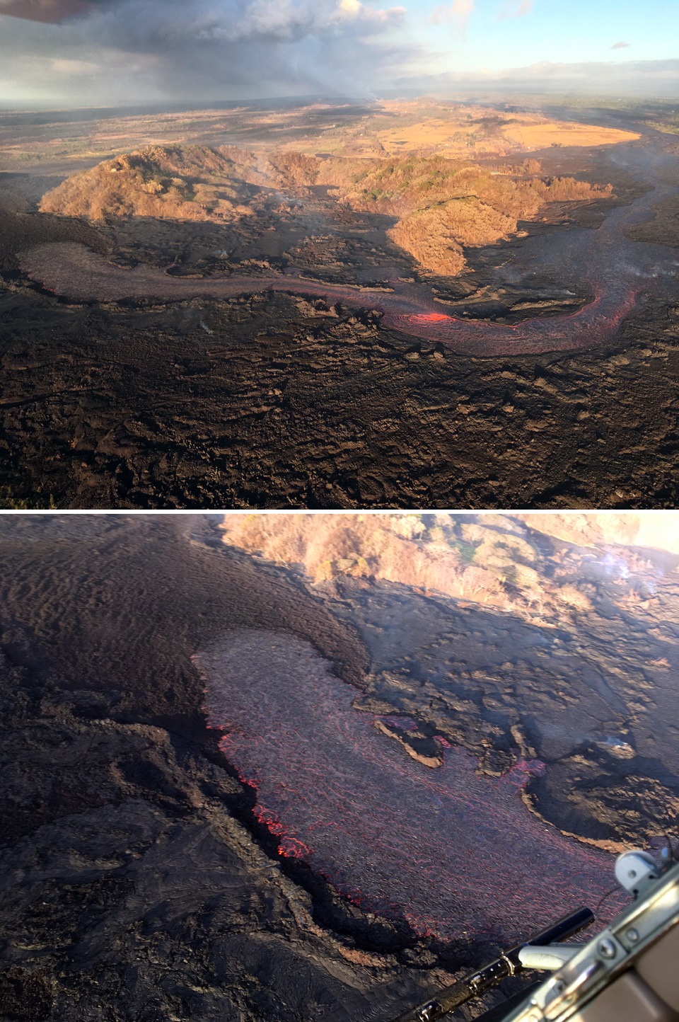
By 9 July the main lava channel had reorganized and was nearly continuous to the ocean on the S side of the flow, expanding the south margin by several hundred meters (figure 431). Lava was also entering the ocean along a 4-km-long line of small entry points across the delta. Early that afternoon observers reported multiple overflows along both sides of the main lava channel in an area just W of Kapoho Crater; small brushfires were reported along the margins. Another flow lobe farther down the channel was moving NE from the main channel. The channel near Four Corners was mostly crusted over, and plumes from the ocean entry were significantly reduced. The dramatic difference in landscapes on the northern and southern sides of the fissure 8 lava channel was readily apparent during a 10 July overflight (figure 432). With dominant trade winds blowing heat and volcanic gases to the SW, the N side of the lava channel remained verdant, while vegetation on the S side was severely impacted and appeared brown and yellow.
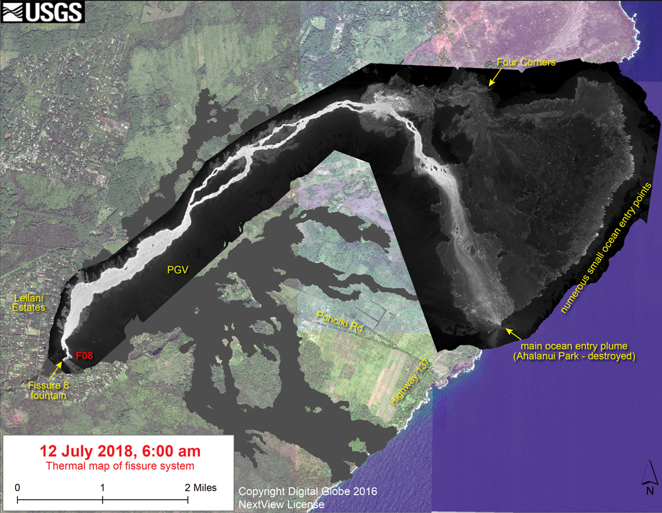
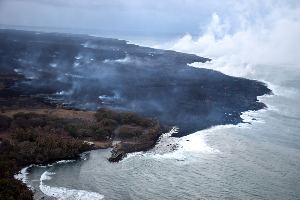
A channel blockage just W of Kapoho Crater overnight on 10-11 July sent most of the channel S along the W edge of previous flows on the W side of the crater. By mid-morning this channelized ?a?a flow had advanced to within 0.5 km of the coast at Ahalanui Beach Park. A few houses were also threatened by overflows along the upper channel on 11 July (figure 433). The broad ocean entry area widened as a result and covered nearly 6 km by 12 July (figure 434).
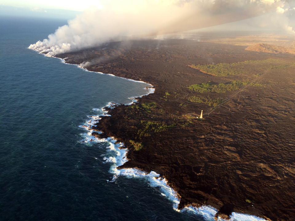
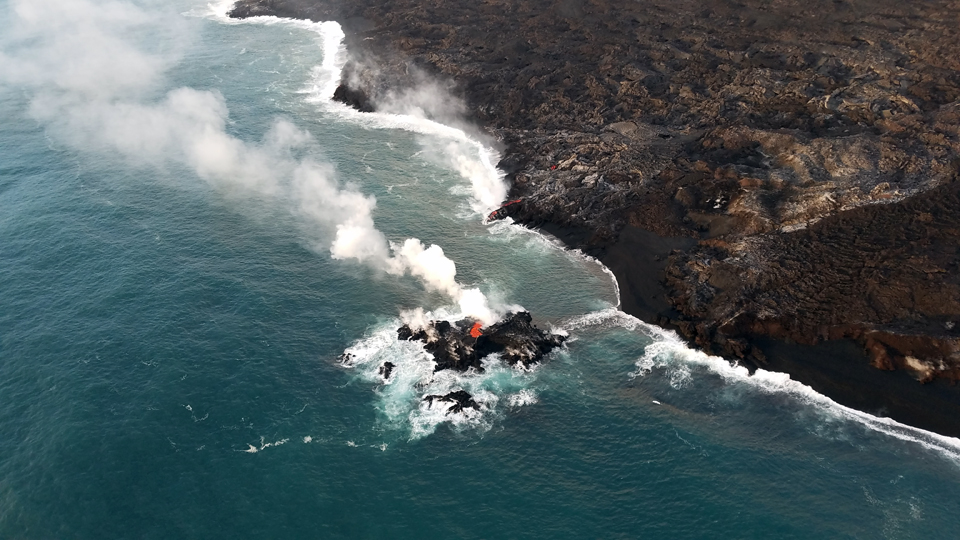
HVO first mentioned a connection between the lava levels in the upper channel of the fissure 8 flow and the collapse-explosion events at the summit on 12 July. They observed a rise in the lava level shortly after each collapse event at the summit for most of the rest of July. Overnight into 12 July, the diverted channelized ?a?a flow W of Kapoho Crater advanced to the ocean destroying the Kua O Ka La Charter School and Ahalanui Count Beach Park and established a robust ocean entry area (figure 435). Despite no visible surface connection to the fissure 8 channel, lava continued to stream out at several points on the 6-km-wide flow front into the ocean. A small island of lava also appeared offshore of the northernmost part of the ocean entry on 12 July (figure 436).
Activity on the LERZ during 13-31 July 2018. As the southern margin of the flow continued to advance slowly south, it reached to within 1 km of the Isaac Hale Park on 14 July and within 750 m on 17 July. An increase in lava supply overnight into 18 July produced several channel overflows threatening homes on Nohea street and also additional overflows downstream on both sides of the channel. The overflows had stalled by mid-morning. South of Kapoho Crater, the surge produced an ?a?a flow that rode over the active southern flow that was still entering the ocean. The southern margin was 500 m from the boat ramp at Isaac Hale Park on 19 July (figure 437).
During the HVO morning overflight on 20 July scientists noted that the channel was incandescent along its entire length from the vent to the ocean entry (figure 438, top). The most vigorous ocean entry was located a few hundred meters NE of the southern flow boundary; a few small pahoehoe flows were also entering the ocean on either side of the channel's main entry point (figure 438, bottom). On 23 July there were overflows just NW of Kapoho Crater following a collapse event at the summit the previous evening. During the day, small breakouts along the edge of the lava flow in the Ahalanui area caused the flow to expand westward. The flow margin was about 175 m from the Pohoiki boat ramp in Isaac Hale Park by the end of 24 July, and the active ocean entry was still a few hundred meters to the E of the lava flow margin. The numerous ocean entry points were concentrated along the southern half of the 6-km-long delta (figure 439).
On 26 July, lava movement in the channel appeared sluggish and levels had dropped in the lower part of the channel compared to previous days. Pulses of lava were recorded every few minutes at the fissure 8 vent (figure 440). HVO suggested that overflows on 28 July may have resulted from a channel surge following a summit collapse event in the morning (figures 441 and 442). Lava was actively entering the ocean along a broad 2 km flow front centered near the former Ahalanui Beach Park, but the edge of the flow remained about 175 m from the Pohoiki boat ramp at Isaac Hale park for the rest of the month. There were a few breakouts to the W that were distant from the coast and not directly threatening Pohoiki. A more minor entry was building a pointed delta near the south edge of the flow. At 2202 on 29 July an earthquake on Kīlauea's south flank was felt as far north as Hilo by a few people. The M 4.1 (NEIC) earthquake was weaker than recent summit earthquakes but it was felt more widely, possibly due to its greater depth of 7 km (compared with 2 km for summit earthquakes).
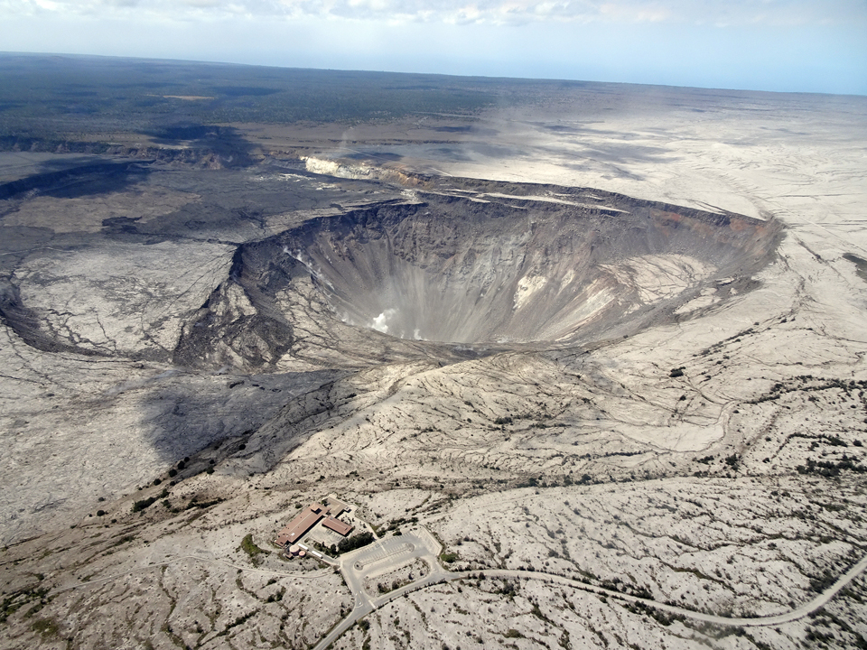
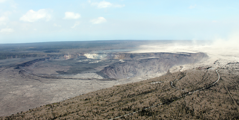
Activity at Halema'uma'u during July and August 2018. Periodic collapse explosion events with energy equivalents to a M 5.2 or 5.3 earthquake continued on a near daily basis throughout July at Halema'uma'u, enlarging the crater floor inside the Kīlauea caldera and creating large down-dropped blocks and fractures across the caldera (figure 443). Ash-poor plumes occasionally rose a few hundred meters above the caldera floor. Summit seismicity would drop dramatically after each explosion and then gradually increase to 25-35 earthquakes (mostly in the M 2-3 range) prior to the next collapse explosion. The periodicity of the explosion events was consistent until 24 July when a gap of 53 hours occurred until the next event on 26 July, the longest break since early June.
Images of the caldera on 13 July and 1 August demonstrated the unprecedented magnitude of change that affected Kīlauea during the month (figures 444 and 445). The last collapse explosion event, at 1155 HST on 2 August, was reported as a M 5.4 seismic event (figure 446). Seismicity increased after the event as it had after previous events, but after reaching about 30 earthquakes per hour on 4 August, seismicity decreased without a collapse-explosion event occurring. The rate of deformation at the summit as measured by tiltmeter and GPS was also much reduced after 4 August.
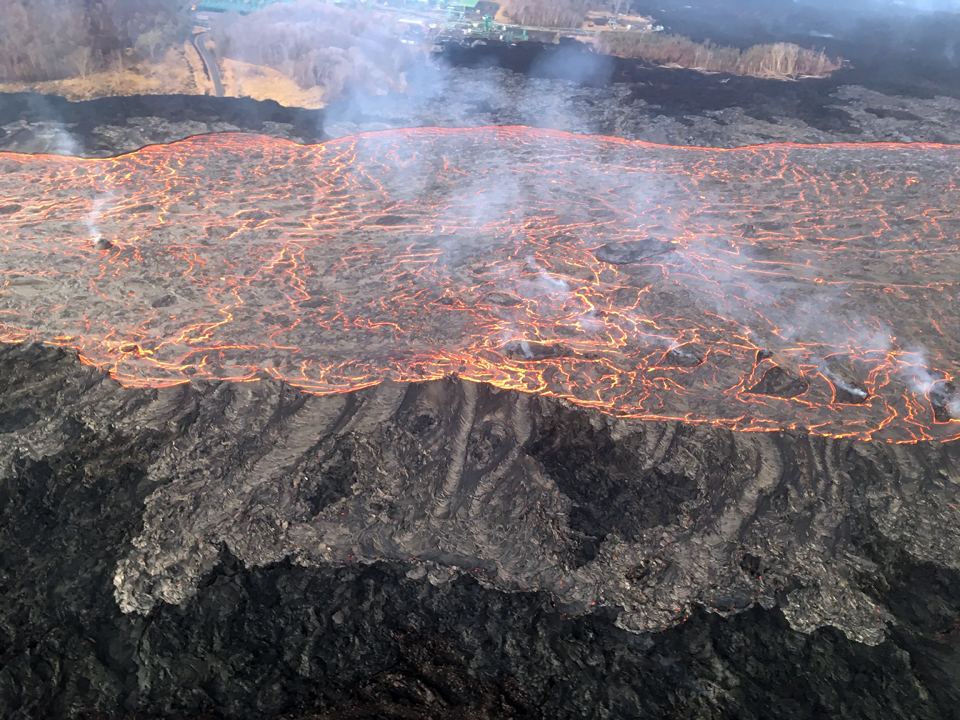
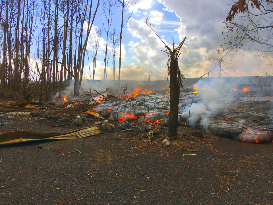
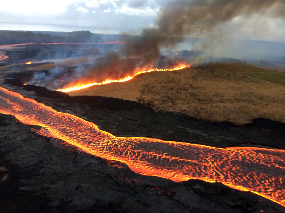
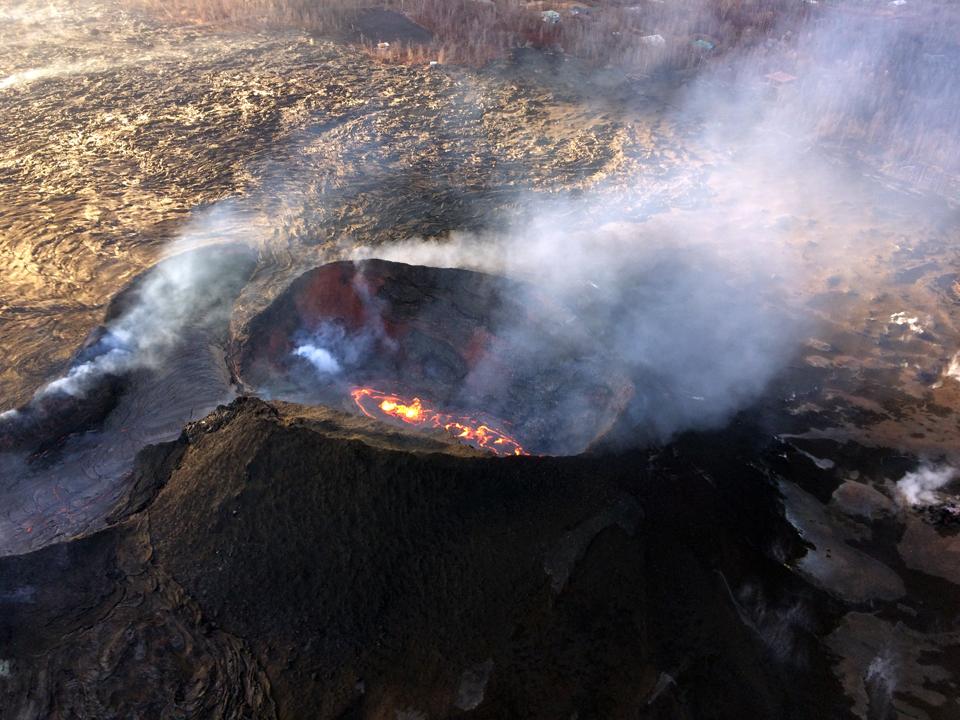
Activity on the Lower East Rift Zone during August 2018. Activity continued essentially unchanged on the fissure 8 flow during 1-4 August, although there were reports of somewhat lower lava levels in the channel. Multiple overflows were reported late on 2 August, one of which started a small fire near Noni Farms Road. Other overflows were concentrated in the wide lava field W and SSW of Kapoho Crater, also igniting small fires in adjacent vegetation (figure 447). The south edge of the flow did not advance any closer to the boat ramp in Isaac Hale Park (figure 448). The channel was incandescent at its surface to approximately 4.5 km from the vent (figure 449); lava was still flowing farther beneath the crust to the vicinity of Kapoho Crater where it was seeping out of both sides of the channel. The lower lava channel adjacent to Kapoho Crater shifted W about 0.25 km early on 4 August and was feeding lava into the SW sector of the lower flow field.
The NE half of the flow's ocean-front was inactive with no evidence of effusion into the ocean by 4 August. Field observations and UAS overflight images indicated a reduced output of lava from fissure 8 during the day on 4 August. During the morning helicopter overflight on 5 August geologists confirmed a significant reduction in lava output from fissure 8 that began the previous day. HVO field geologists observed low levels of fountaining within the fissure 8 spatter cone and largely crusted lava in the spillway and channel system downstream (figure 450). The lava level in the channel near Kapoho Crater had dropped substantially on 5 August. (figure 451).
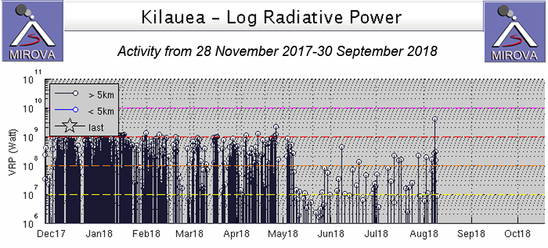
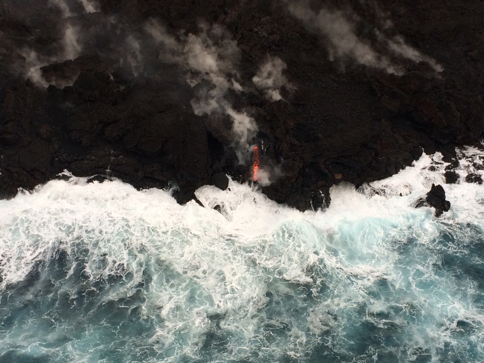
Lava continued to slowly enter the ocean along a broad flow front generally near Pohoiki, but remained about 70 m SE of the boat ramp on 5 August. The next morning's overflight crew saw a weak to moderately active bubbling lava lake within the fissure 8 cone, a weak gas plume, and a completely crusted lava channel. Later in the morning ground crews found the upper channel largely devoid of lava, confirming that the channel was empty to at least the vicinity of Kapoho Crater where a short section of spiny active lava in a channel was present. There were small active breakouts near the coast on the Kapoho Bay and Ahalanui lobes, but the laze plume was greatly diminished. Active lava was close to the Pohoiki boat ramp but had not advanced significantly toward it. A major change in the heat flow recorded by satellite instruments was apparent by the end of the first week in August (figure 452). The MIROVA signal, which had shown a persistent high-intensity thermal signal for several years, recorded an abrupt drop in activity early in May that coincided with the opening of the fissures on the LERZ, and the dropping of the lava lake at Halema'uma'u. The lower levels of heat flow fluctuated from May through early August, and then ended abruptly after the first week of August.
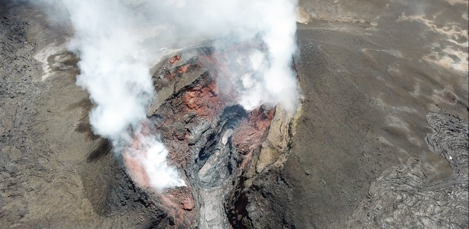
On 7 August the surface of the lava lake was about 5-10 m below the spillway entrance (figure 453) and the upper part of the channel was crusted over (figure 454). There were a diminishing number of small active flow points near the coast on the Kapoho Bay and Ahalanui lobes. By 9 August the overflight crew observed a crusted lava pond deep inside the steaming cone at a level significantly below that seen on 7 August. Up-rift of fissure 8, fissures 9, 10, and 24, and down-rift fissures 13, 23, 3, 21 and 7, continued to steam, but no new activity was observed. Lava was streaming at several points along the Kapoho Bay and Ahalanui coastline, causing wispy laze plumes on 10 August, and only minor areas of incandescence were visible in the lava pond inside the fissure 8 cone (figure 455). The next day the overflight crew noted two small ponds of lava inside the cone; one was crusted over and stagnant, and the other was incandescent and sluggishly convecting. A gas plumed billowed up from fissure 8 and low-level steaming was intermittent from a few of the otherwise inactive fissures.
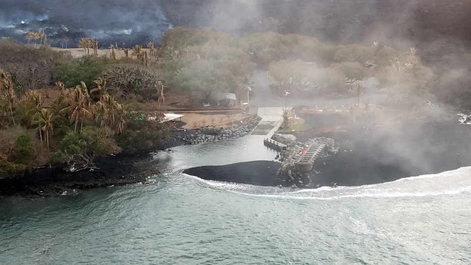
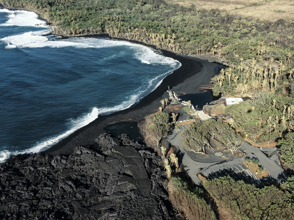
By 12 August the only incandescent lava visible on the flow field was that entering the ocean between Kapoho Bay and the Ahalanui area. Fresh black sand, created as molten lava is chilled and shattered by the surf, was being transported SW by longshore currents and accumulating in the Pohoiki small boat harbor (figure 456). A sandbar blocked the entrance to the harbor the following day. The westernmost ocean entry of lava was about 1 km from the harbor on 13 August.
By 14 August only a small, crusted over pond of lava deep inside the fissure 8 cone and a few scattered ocean entries were active; there had been no new lava actively flowing in the lower East Rift Zone since 6 August. No collapse events had occurred at the summit since 2 August. Earthquake and deformation data showed no net changes suggesting movement of subsurface magma or pressurization. Sulfur dioxide emission rates at both the summit and LERZ were drastically reduced; the combined rate was lower than at any time since late 2007. As a result of the reduced activity, HVO lowered the Alert Level for ground-based hazards from WARNING to WATCH on 17 August. By 18 August, the only incandescence visible was at the coast near Ahalanui, where there were a few ocean entries and minor laze plumes (figure 457).
Gas jets were throwing spatter, fragments of glassy lava, from small incandescent areas deep within the fissure 8 cone on 20 August (figure 458). The last day that the small lava pond deep within the fissure 8 cone was visible during an overflight was on 25 August; a few ocean entries were still active. A single small lava stream from the Kapoho Bay lobe was the only moving lava noted during an HVO overflight on 27 August (figure 459). Two days later, on 29 August, no lava was entering the ocean.
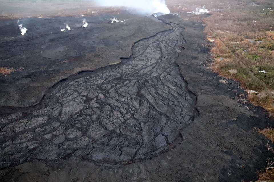
The fissure 8 lava flow entering the ocean had built a lava delta over 354 hectares (875 acres) in size by the end of August 2018 (figure 460). A sand bar, comprised of black sand and lava fragments carried by longshore currents from the lava delta, completely blocked the boat ramp at Isaac Hale Beach Park on 31 August 2018 (figure 461).
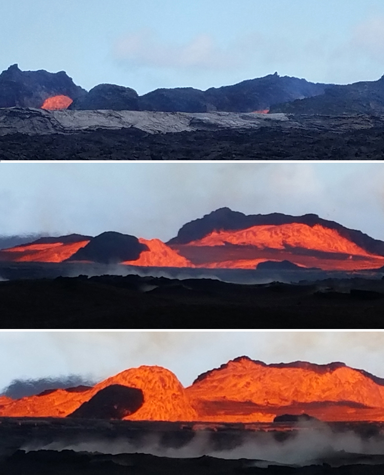
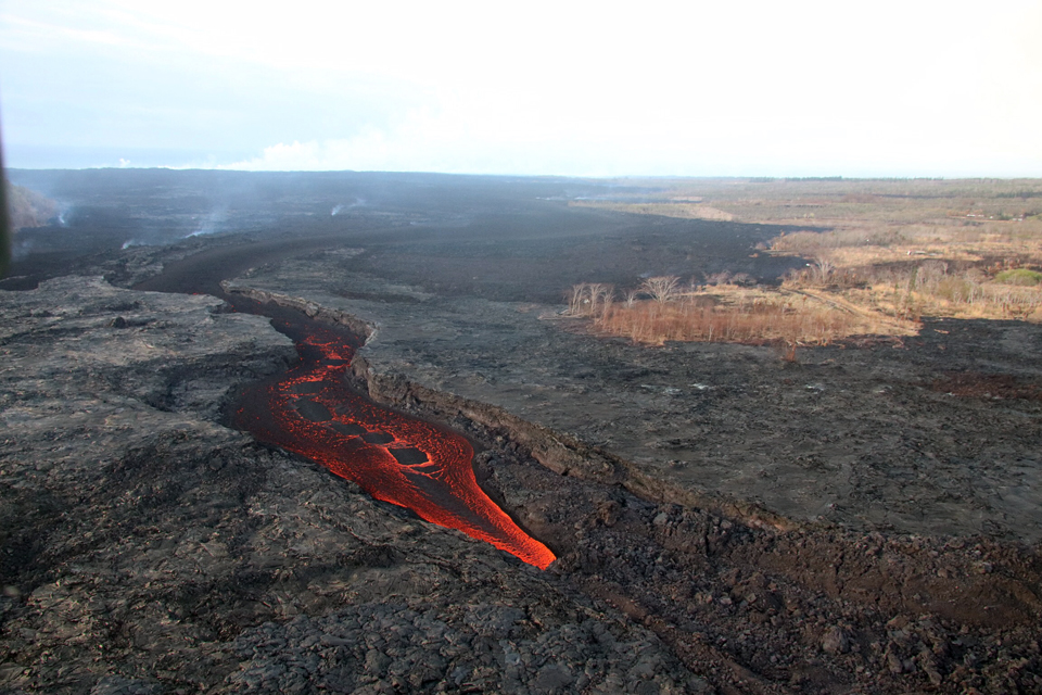
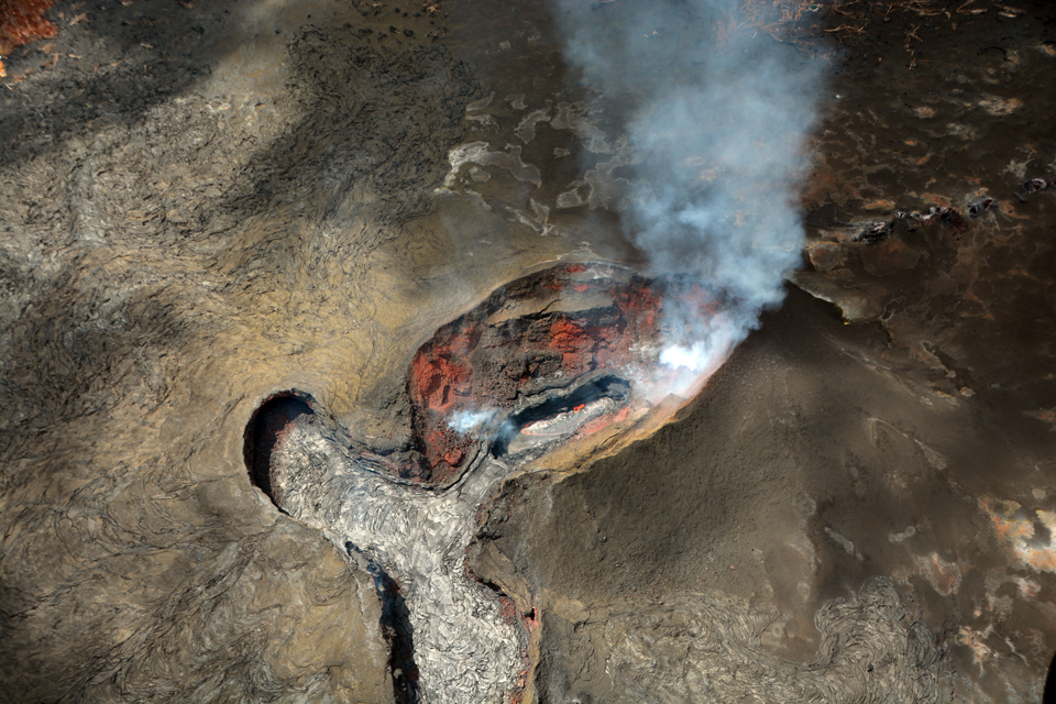
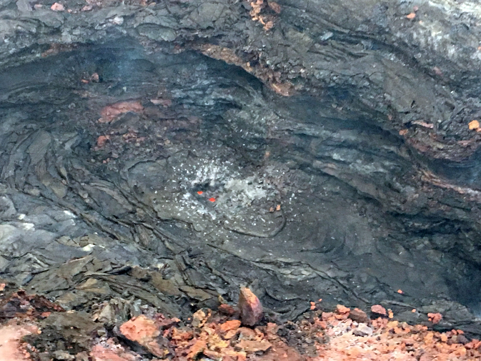
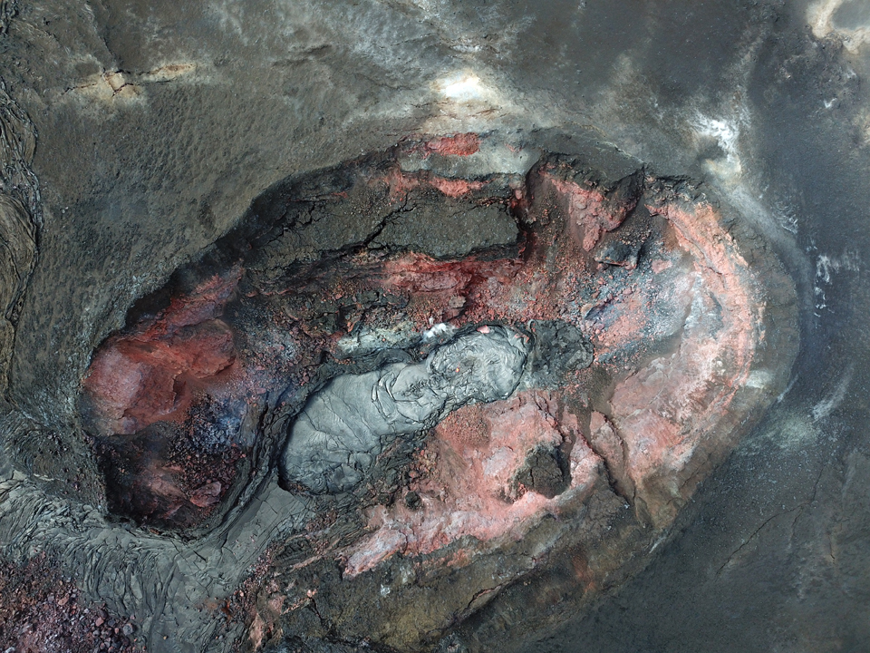
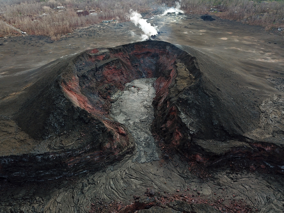
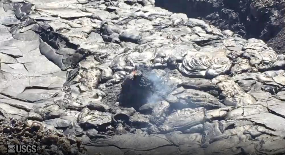
Activity during September 2018. A brief resurgence of minor activity during the first few days of September was the last observed from LERZ fissure 8. Incandescence was noted in the fissure 8 cone on 1 September. There was a persistent spot of spattering, and lava slowly covered the 15 x 65 m crater floor by evening (figure 462). Webcam views showed weak incandescence occasionally reflected on the eastern spillway wall from the crater overnight, suggesting that the lava in the crater remained active. A UAS oblique image the next afternoon showed that the new lava was mostly confined to the crater floor within the cone, although a small amount extended a short distance into the spillway (figure 463). Weak lava activity continued inside the fissure 8 cone for several days; lava filled the small footprint-shaped crater inside the cone as sluggish pahoehoe flows crept across the crater floor but did not flow down the spillway. A small spatter cone ejecting material every few seconds was noted on the floor of the crater on 4 September; observations the next day showed that it had reached an estimated height of around 3-4 m (figure 464). Only a small amount of incandescence was visible overnight on 5-6 September at fissure 8.
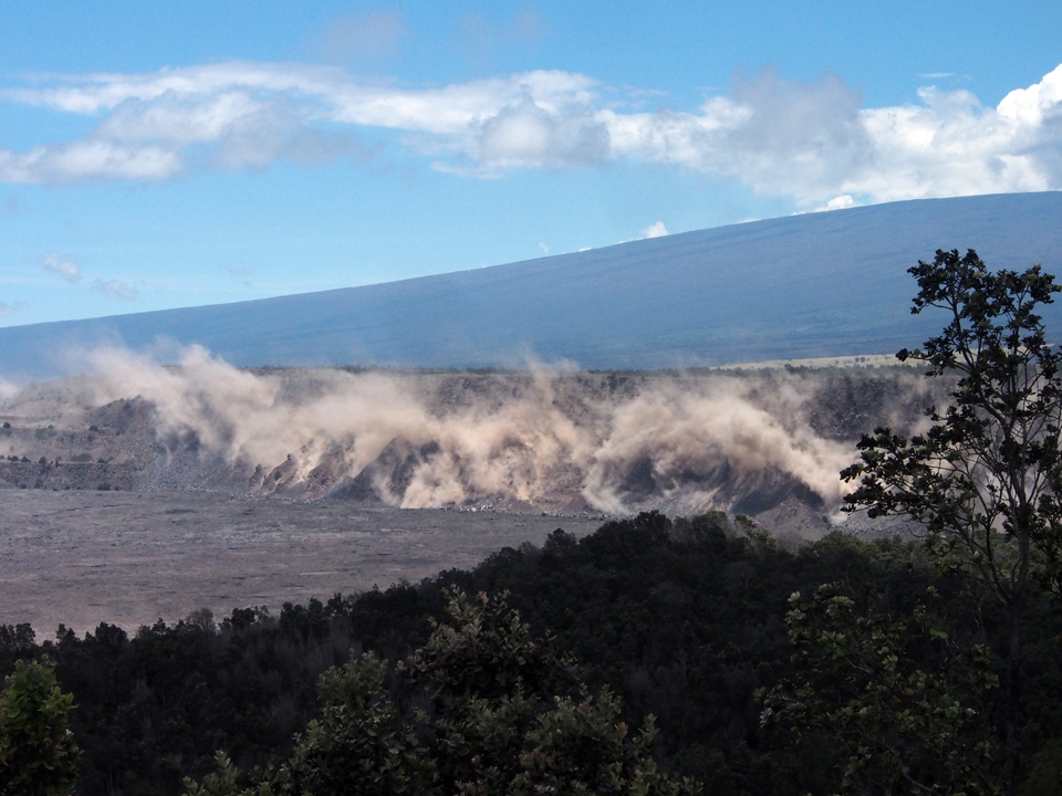
Pu'u O'o crater experienced a series of small collapses on 8 September. These produced episodes of visible brown plumes throughout the day and generated small tilt offsets and seismic energy recorded by nearby geophysical instruments. The collapses had no discernable effect on other parts of the rift and continued for several days at a decreasing frequency. Minor amounts of incandescence and fuming continued to be observed on 9 September at the fissure 8 cone. A small collapse pit formed in the cone on 10 September exposing hot material underneath and producing a short-lived increase in incandescence. Minor fuming was visible the next day from the small spatter cone. Incandescence at the collapse pit decreased over the next few days, but a glowing spot just west of the pit appeared on 11 September and grew slowly for a few days before diminishing. HVO interpreted it to be a layer of incandescence exposed in the slowly subsiding lava surface within the fissure 8 cone. Minimal incandescence was visible overnight on 14-15 September. After this, only minor fuming was visible during the day; incandescence was no longer observed for the remainder of the month.
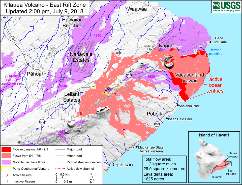
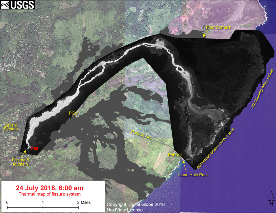
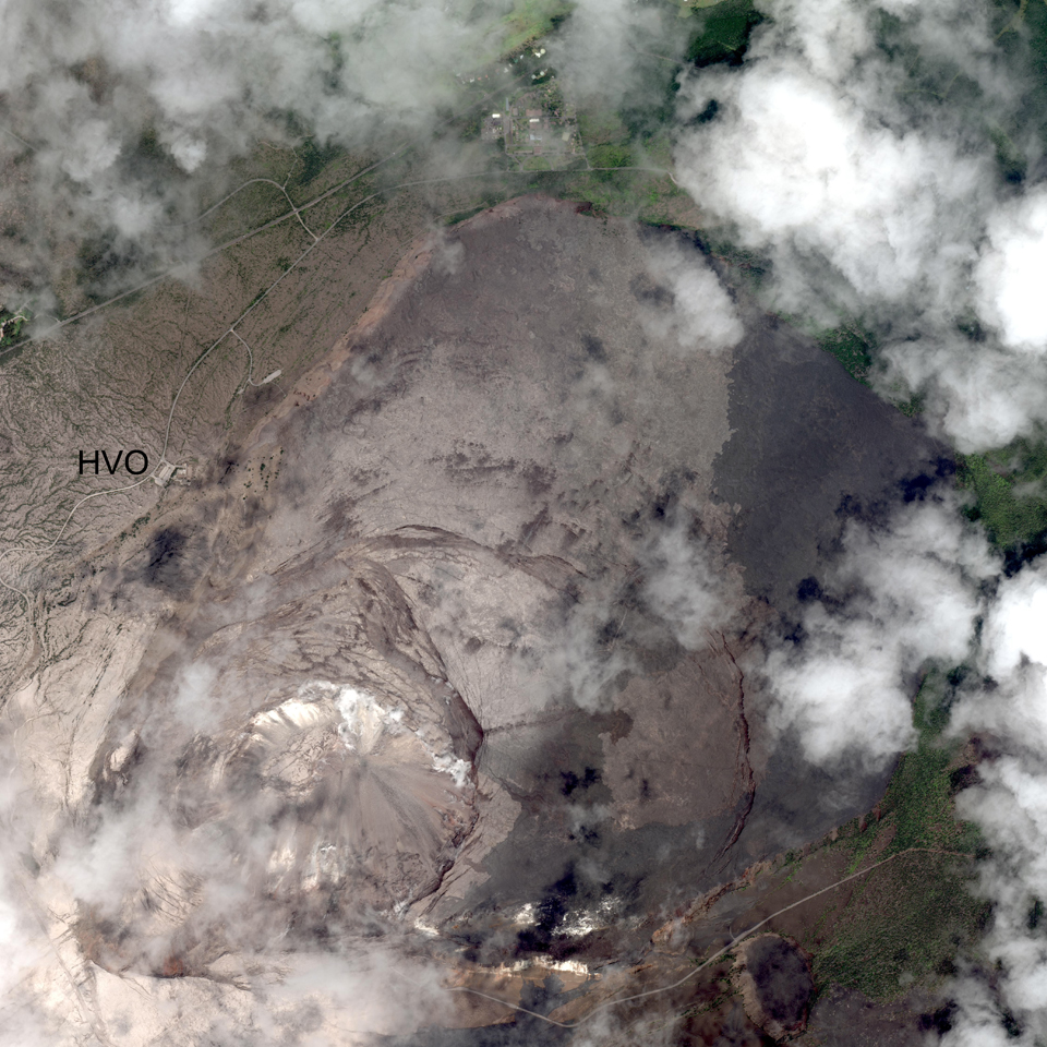
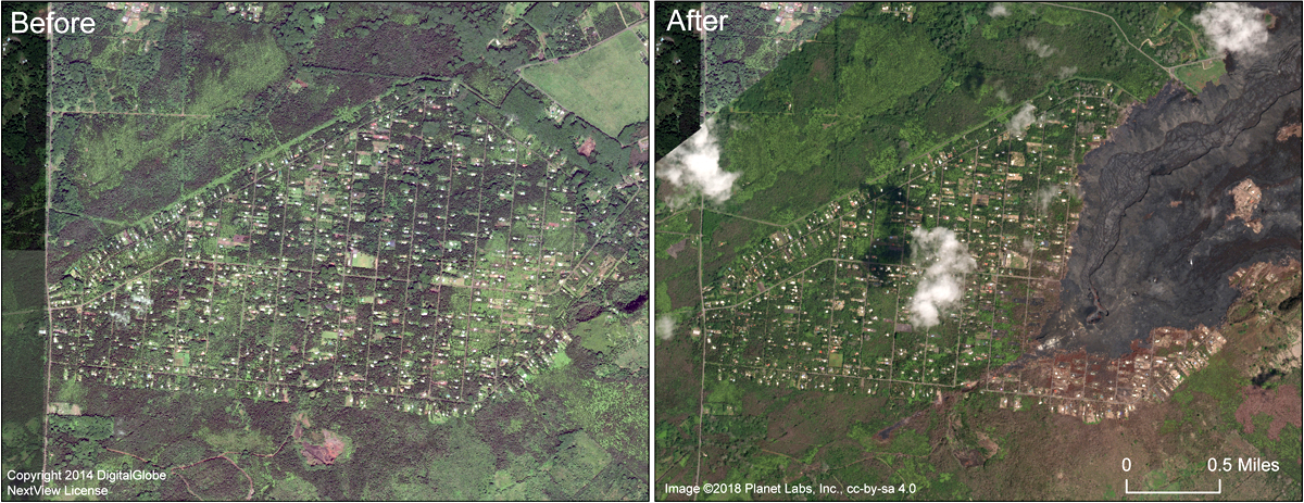
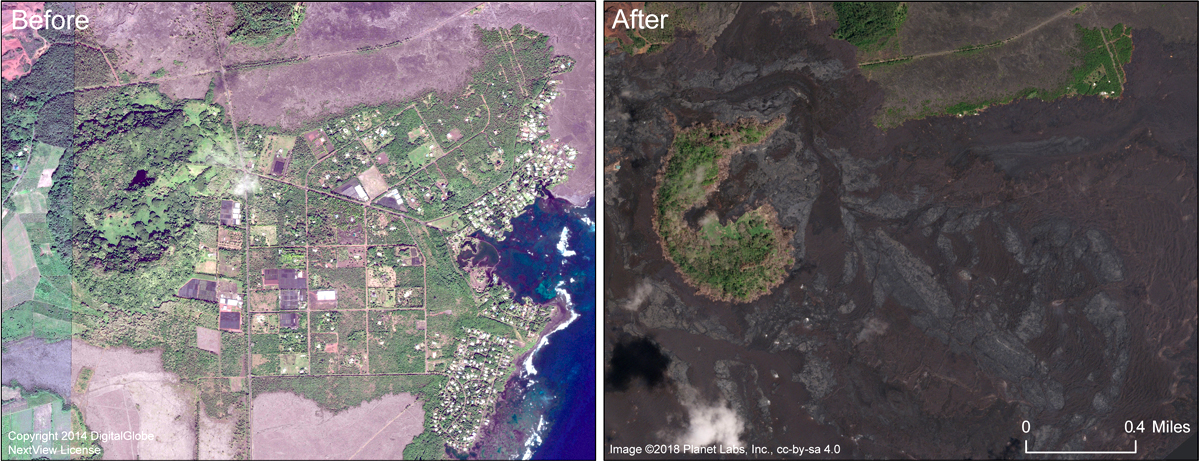
HVO determined that the 2018 Lower East Rift Zone eruptive episode ended on 5 September 2018, bringing with it an end to the lava lake at Halema'uma'u crater and the eruptive activity that had been continuous at either Pu'u O'o or Halema'uma'u since 3 January 1983; a period of more than 36 years. Satellite imagery from early September 2018 demonstrated some of the impact of this last eruptive episode on the region around Kīlauea's lower East Rift Zone since the first fissure opened at the beginning of May 2018 (figures 465 and 466).
Geological Summary. Kilauea overlaps the E flank of the massive Mauna Loa shield volcano in the island of Hawaii. Eruptions are prominent in Polynesian legends; written documentation since 1820 records frequent summit and flank lava flow eruptions interspersed with periods of long-term lava lake activity at Halemaumau crater in the summit caldera until 1924. The 3 x 5 km caldera was formed in several stages about 1,500 years ago and during the 18th century; eruptions have also originated from the lengthy East and Southwest rift zones, which extend to the ocean in both directions. About 90% of the surface of the basaltic shield volcano is formed of lava flows less than about 1,100 years old; 70% of the surface is younger than 600 years. The long-term eruption from the East rift zone between 1983 and 2018 produced lava flows covering more than 100 km2, destroyed hundreds of houses, and added new coastline.
Information Contacts: Hawaiian Volcano Observatory (HVO), U.S. Geological Survey, PO Box 51, Hawai'i National Park, HI 96718, USA (URL: http://hvo.wr.usgs.gov/); MIROVA (Middle InfraRed Observation of Volcanic Activity), a collaborative project between the Universities of Turin and Florence (Italy) supported by the Centre for Volcanic Risk of the Italian Civil Protection Department (URL: http://www.mirovaweb.it/).