Report on Erebus (Antarctica) — January 2019

Bulletin of the Global Volcanism Network, vol. 44, no. 1 (January 2019)
Managing Editor: Edward Venzke.
Research and preparation by Paul Berger.
Erebus (Antarctica) Lava lakes persist through 2017 and 2018
Please cite this report as:
Global Volcanism Program, 2019. Report on Erebus (Antarctica) (Venzke, E., ed.). Bulletin of the Global Volcanism Network, 44:1. Smithsonian Institution. https://doi.org/10.5479/si.GVP.BGVN201901-390020
Erebus
Antarctica
77.53°S, 167.17°E; summit elev. 3794 m
All times are local (unless otherwise noted)
Between the early 1980's through 2016, activity at Erebus was monitored by the Mount Erebus Volcano Observatory (MEVO), using seismometers, infrasonic recordings to measure eruption frequency, and annual scientific site visits. MEVO recorded occasional explosions propelling ash up to 2 km above the summit of this Antarctic volcano and the presence of two, sometimes three, lava lakes (figure 26). However, MEVO closed in 2016 (BGVN 42:06).
Activity at the lava lakes in the summit crater can be detected using MODIS infrared detectors aboard the Aqua and Terra satellites and analyzed using the MODVOLC algorithm. A compilation of thermal alert pixels during 2017-2018 (table 4, a continuation of data in the previous report) shows a wide range of detected activity, with a high of 182 alert pixels in April 2018. Although no MODVOLC anomalies were recorded in January 2017, detectors on the Sentinel-2 satellite imaged two active lava lakes on 25 January.
Table 4. Number of MODVOLC thermal alert pixels recorded per month from 1 January 2017 to 31 December 2018 for Erebus by the University of Hawaii's thermal alert system. Table compiled by GVP from data provided by MODVOLC.
| Year | Jan | Feb | Mar | Apr | May | Jun | Jul | Aug | Sep | Oct | Nov | Dec | SUM |
| 2017 | 0 | 21 | 9 | 0 | 0 | 1 | 11 | 61 | 76 | 52 | 0 | 3 | 234 |
| 2018 | 0 | 21 | 58 | 182 | 55 | 17 | 137 | 172 | 103 | 29 | 0 | 0 | 774 |
| SUM | 0 | 42 | 67 | 182 | 55 | 18 | 148 | 233 | 179 | 81 | 0 | 3 | 1008 |
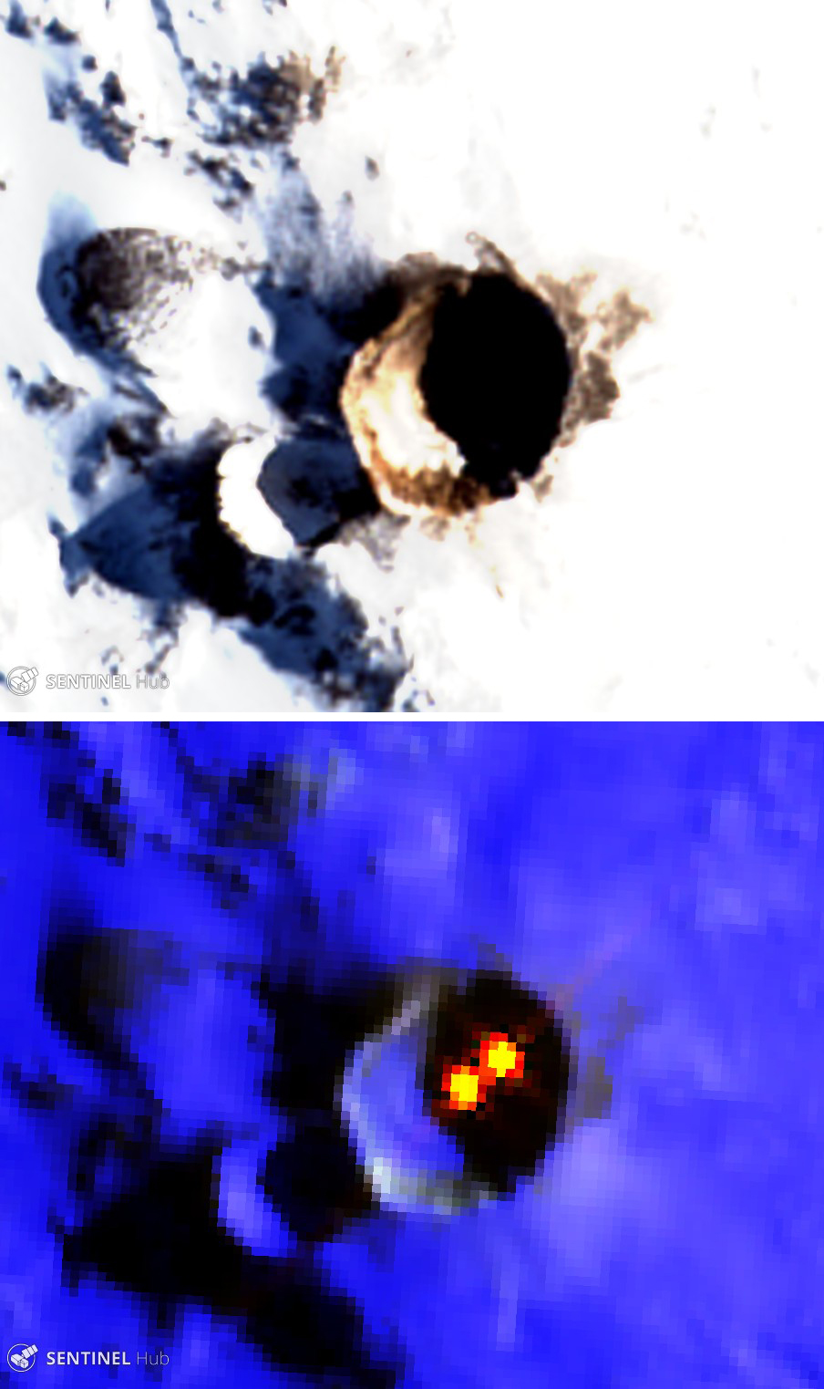 |
Figure 26. Sentinel-2 images of the summit crater area of Erebus on 25 January 2017. Top: Natural color filter (bands 4, 3, 2). Bottom: Atmospheric penetration filter (bands 12, 11, 8A) in which two distinct lava lakes can be observed. The main crater is 500 x 600 m wide. Courtesy of Sentinel Hub Playground. |
Geological Summary. Mount Erebus, the world's southernmost historically active volcano, overlooks the McMurdo research station on Ross Island. It is the largest of three major volcanoes forming the crudely triangular Ross Island. The summit of the dominantly phonolitic volcano has been modified by one or two generations of caldera formation. A summit plateau at about 3,200 m elevation marks the rim of the youngest caldera, which formed during the late-Pleistocene and within which the modern cone was constructed. An elliptical 500 x 600 m wide, 110-m-deep crater truncates the summit and contains an active lava lake within a 250-m-wide, 100-m-deep inner crater; other lava lakes are sometimes present. The glacier-covered volcano was erupting when first sighted by Captain James Ross in 1841. Continuous lava-lake activity with minor explosions, punctuated by occasional larger Strombolian explosions that eject bombs onto the crater rim, has been documented since 1972, but has probably been occurring for much of the volcano's recent history.
Information Contacts: Hawai'i Institute of Geophysics and Planetology (HIGP) - MODVOLC Thermal Alerts System, School of Ocean and Earth Science and Technology (SOEST), Univ. of Hawai'i, 2525 Correa Road, Honolulu, HI 96822, USA (URL: http://modis.higp.hawaii.edu/); Sentinel Hub Playground (URL: https://www.sentinel-hub.com/explore/sentinel-playground).