Report on Popocatepetl (Mexico) — March 2019

Bulletin of the Global Volcanism Network, vol. 44, no. 3 (March 2019)
Managing Editor: Edward Venzke.
Edited by A. Elizabeth Crafford.
Popocatepetl (Mexico) Explosions with ash plumes and incandescent ejecta continue during September 2018-February 2019
Please cite this report as:
Global Volcanism Program, 2019. Report on Popocatepetl (Mexico) (Crafford, A.E., and Venzke, E., eds.). Bulletin of the Global Volcanism Network, 44:3. Smithsonian Institution. https://doi.org/10.5479/si.GVP.BGVN201903-341090
Popocatepetl
Mexico
19.023°N, 98.622°W; summit elev. 5393 m
All times are local (unless otherwise noted)
Frequent historical eruptions have been reported from Mexico's Popocatépetl going back to the 14th century. Activity increased in the mid-1990s after about 50 years of quiescence, and the current eruption, ongoing since January 2005, has included numerous episodes of lava-dome growth and destruction within the 500-m-wide summit caldera. Multiple emissions of steam and gas occur daily, rising generally 1-3 km above the 5.4-km-elevation summit; many contain small amounts of ash. Larger, more explosive events with ash plumes and incandescent ejecta landing on the flanks usually occur several times every week.
Activity through August 2018 was typical of the ongoing eruption with near-constant emissions of water vapor, gas, and minor ash, as well as multiple explosions every week with ash-plumes and incandescent blocks scattered on the flanks (BGVN 43:11). This report covers similar activity from September 2018 through February 2019. Information about Popocatépetl comes from daily reports provided by México's Centro Nacional de Prevención de Desastres (CENAPRED); ash emissions are also reported by the Washington Volcanic Ash Advisory Center (VAAC). Satellite visible and thermal imagery and SO2 data also provide helpful observations of activity.
Near-constant emissions of steam and gas, often with minor ash content, were typical activity throughout September 2018-February 2019. Intermittent larger explosions with plumes of moderate ash content that generated ashfall in nearby communities were reported each month except November. Periods with increased explosive activity that consisted of multiple daily explosions included all of September into early October, early December 2018, and the second half of February 2019 (figure 116). Increased observations of incandescence at the summit generally coincided with increases in explosive activity. Increases in thermal anomalies measured by the MIROVA project during this time also correlated with times of increased explosive activity as reported by CENAPRED (figure 117).
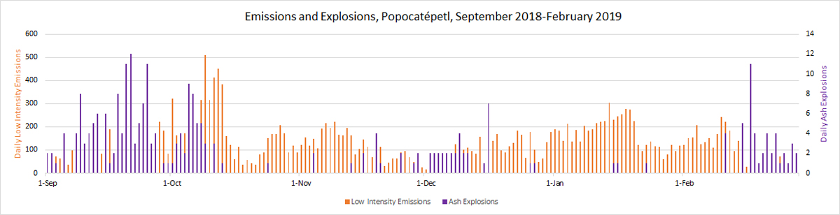 |
Figure 116. The numbers of low intensity emissions of steam and gas, often with minor amounts of ash ranged from a few tens to several hundred per day throughout September 2018-February 2019 (blue, left axis). Increases in the daily numbers of larger ash-bearing explosions occurred during September-early October 2018, early December, and the second half of February 2019 (orange, right axis). Data courtesy of CENAPRED. |
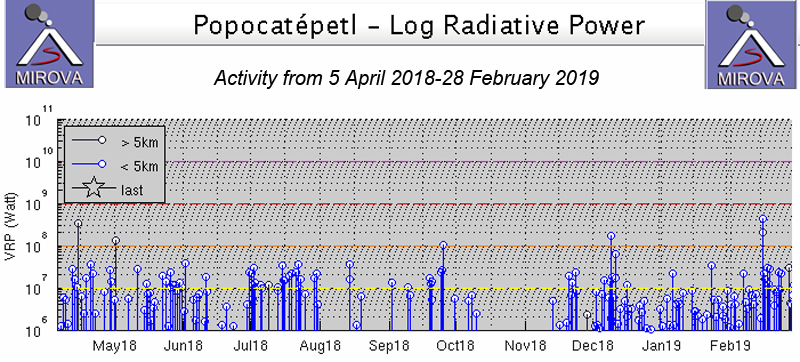 |
Figure 117. Thermal anomalies registered by the MIROVA project from 5 April 2018 through February 2019 had periods of increased frequency and intensity during September-early October, early December 2018, and in the second half of February 2019. Courtesy of MIROVA. |
Activity during September 2018. Multiple explosions with ash plumes were reported nearly every day in September (figure 118). The Washington VAAC reported an ash plume visible in satellite imagery 15 km NW of the summit at 7.6 km altitude on 4 September. Most plumes reported by the VAAC during the month rose to 6.1-7.6 km and drifted up to 40 km in multiple directions. Two small episodes of ash emissions with tremor on 16 September were followed the next day by a series of emissions, explosions, and tremor that lasted for over six hours; incandescent blocks were visible on the flanks in the early morning. An increase in activity late on 18 September produced Strombolian eruptions that lasted for nearly eight hours along with ash emissions and incandescent blocks on the flanks. A plume on 19 September still had detectable ash 150 km NE of the summit; a smaller plume drifting E was responsible for ashfall reported in Tlaxcala.
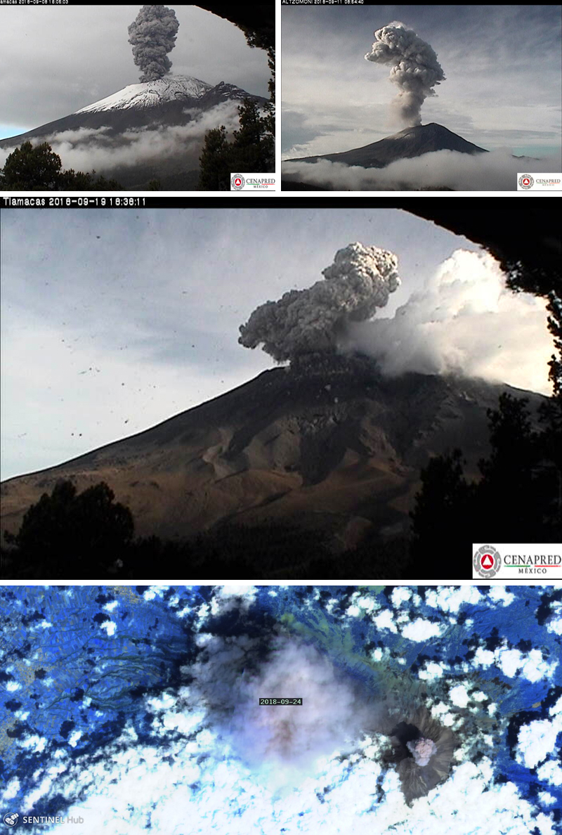 |
Figure 118. Multiple explosions with ash plumes were reported nearly every day in September at Popocatépetl, generating ash plumes that rose from 1.5-3 km above the crater and drifted in multiple directions. The CENAPRED webcams captured images of ash plumes on 8, 11, and 19 September, and the Sentinel-2 satellite (rendering is Atmospheric penetration, based on bands 12, 11 and 8A) imaged ash plumes from two of seven reported explosions on 24 September 2018. Courtesy of CENAPRED (Reporte del monitoreo de CENAPRED al volcán Popocatépetl hoy 9, 11, y 20 de septiembre de 2018) and Sentinel Hub Playground (lower image). |
Discrete puffs of ash were observed by the Washington VAAC on 20 September moving WSW extending around 200 km from the summit. Three explosions on 21 September ejected incandescent blocks onto the NE flank. During an overflight on 21 September, CENAPRED observed dome number 80, partly destroyed by the recent explosions (figure 119). The Washington VAAC reported an ash plume at 8.8 km altitude on 21 September 30 km WSW from the summit. Ashfall was reported by CENACOM (Mexican National Communications Center) on 29 September in Atlautla, Tehuixtitlan, and Cuecuecuautitla in the State of Mexico, and in the Tláhuac Delegation, Iztapalapa, and Xochimilco in Mexico City.
 |
Figure 119. During an overflight on 21 September 2018, CENAPRED observed dome number 80 at Popocatépetl, partly destroyed by the recent explosions. Courtesy of CENAPRED (Sobrevuelo al volcán Popocatépetl hoy 21 de septiembre de 2018). |
Activity during October and November 2018. The Washington VAAC reported an ash plume at 7 km altitude on 2 October, 35 km W of the summit. Numerous smaller plumes were reported by the VAAC during both months at about 6 km altitude drifting in multiple directions. Two larger explosions on 8 October produced ash plumes that rose to 3.5 and 2.4 km, respectively, above the summit, and drifted NE (figure 120). As a result, ashfall was reported at the Puebla airport. On 10 and 12 October, extended periods of LP tremor were accompanied by gas emissions, but otherwise lower levels of activity were noted for much of the month. An ash plume extended over 80 km NE at 7.6 km altitude on 10 November. An explosion on 13 November produced incandescent fragments on the flanks. During 19-21 November episodes of LP seismicity and tremors produced gas and ash emissions; some of the episodes lasted for as long as 13 hours; incandescent fragments were observed on the upper slopes during the more intense periods. On 22 November scientists on an overflight by CENAPRED observed dome 81 with a diameter of 175 m and an estimated depth of 30 m (figure 121).
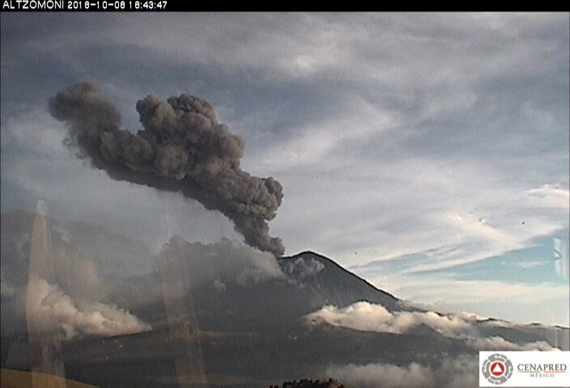 |
Figure 120. A large explosion early on 8 October 2018 at Popocatépetl sent an ash plume to 3.5 km above the summit crater that drifted NE. Courtesy of CENAPRED (Reporte del monitoreo de CENAPRED al volcán Popocatépetl 9 de Octubre de 2018). |
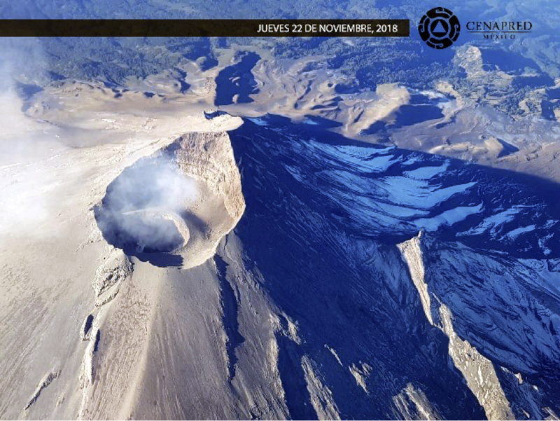 |
Figure 121. On 22 November 2018 scientists on an overflight by CENAPRED observed dome 81 at Popocatépetl with a diameter of 175 m and an estimated depth of 30 m. Courtesy of CENAPRED (Sobrevuelos, herramienta útil para el monitoreo volcánico del Popocatépetl, jueves, 22 de noviembre de 2018). |
Activity during December 2018. Increased ash emissions were reported in early December 2018, producing ash plumes that rose at least 1 km above the crater and drifted mostly E; incandescent blocks ejected on 5 December fell mostly back into the crater. Multiple explosions on 6 and 7 December produced ash plumes that rose as high as 2.5 km above the crater and resulted in ashfall in Amecameca and Tlalmanalco; they also produced incandescent blocks that traveled as far at 2.5 km from the crater, according to CENAPRED. An explosion on 9 December produced a 2-km-high ash plume that drifted NE (figure 122). Satellite images captured during clear skies on 18 December showed incandescence at the dome inside the summit crater, and dark ash and ejecta covering much of the upper flanks (figure 123). An ash plume was centered about 100 km NE of the summit on 24 December at 7.6 km altitude, and dissipating rapidly, according to the Washington VAAC. Incandescent blocks were ejected onto the flanks on 26 December during an evening explosion.
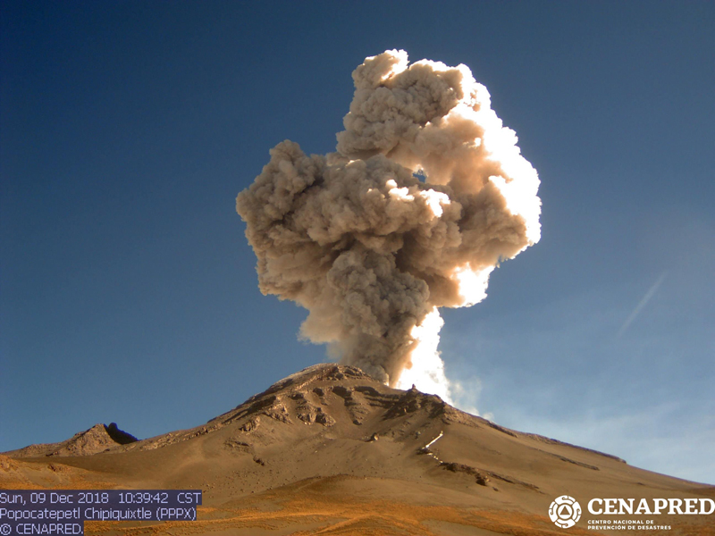 |
Figure 122. An explosion on 9 December 2018 produced a 2-km-high ash plume at Popocatépetl that drifted NE. Courtesy of CENAPRED (Reporte del monitoreo de CENAPRED al volcán Popocatépetl hoy 9 de diciembre de 2018). |
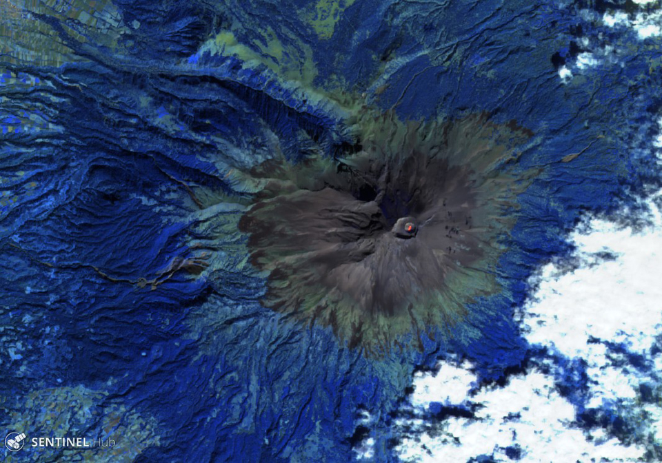 |
Figure 123. Clear skies on 18 December 2018 resulted in a Sentinel-2 satellite image of Popocatépetl that showed incandescence on the dome inside the summit crater, and dark tephra surrounding all the upper flanks. Rendering is Atmospheric penetration, based on bands 12, 11 and 8A. Courtesy of Sentinel Hub Playground. |
Activity during January 2019. An explosion in the early morning of 16 January 2019 produced incandescent blocks that traveled 1.5 km down the slopes. It also produced an ash emission that lasted for 25 minutes; the seismic signal associated with the event was a mixture of harmonic tremor and high-frequency low-amplitude earthquakes. In the first minutes the height of the column reached 1,000 m above the crater, later it decreased to 500 m; ash was dispersed ENE. Late on 22 January a large explosion produced an ash plume that rose 3.5 km above the crater and numerous incandescent blocks that were observed as far as 2 km from the summit (figure 124); ashfall was reported in Santa Isabel Cholula, Santa Ana Xalmimilulco, Domingo Arenas, San Martin Texmelucan, Tlalancaleca, San Salvador el Verde, San Andres Calpan, San Nicolás de los Ranchos, and Huejotzingo, all in the state of Puebla. A large discrete ash plume was observed in satellite imagery by the Washington VAAC on 24 January at 6.7 km altitude moving NE to about 35 km distance before dissipating. In an overflight on 27 January CENAPRED noted that the internal crater remained about 300 m wide and 150 m deep, and no dome was visible (figure 125).
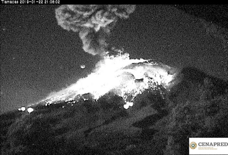 |
Figure 124. Late on 22 January 2019 a large explosion at Popocatépetl produced an ash plume that rose 3.5 km above the crater and produced numerous incandescent blocks that were observed as far as 2 km from the summit. Courtesy of CENAPRED (Actualización de Reporte del monitoreo de CENAPRED al volcán Popocatépetl hoy 22 de enero de 2019). |
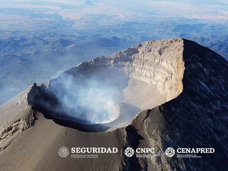 |
Figure 125. During an overflight of Popocatépetl on 27 January 2019 observers from CENAPRED noted that the internal crater remained about 300 m wide and 150 m deep, and no dome was visible. Courtesy of CENAPRED (Reporte del monitoreo de CENAPRED al volcán Popocatépetl hoy 27 de enero de 2019). |
Activity during February 2019. Several days of increased activity of harmonic tremor and explosions were reported during 14-19 February 2019 (figure 126). Incandescent blocks from Strombolian activity appeared on the flanks late on 14 February traveling as far as 1.5 km, along with a continuous stream of ash and gas that drifted SW for seven hours. The initial ash plume rose 800 m, but by early the next day had risen to 2 km. Ashfall was reported in the communities of Hueyapan, Tetela del Volcán, Zacualpan, Temoac, Jantetelco, Cuautla, Ocuituco, and Yecapixtla, in the state of Morelos, and in Tochimilco, Puebla, on 15 February.
 |
Figure 126. Several days of increased activity at Popocatépetl, including harmonic tremor and explosions, were reported during 14-19 February 2019. Incandescent blocks from Strombolian activity appeared on the flanks late on 14 February traveling as far as 1.5 km, along with a continuous stream of ash and gas that drifted SW for seven hours (left). Steam and gas streamed continuously from the summit for many hours on 17 February (right); the plume drifted NNE at 1-1.5 km altitude. Courtesy of CENAPRED (Reporte del monitoreo de CENAPRED al volcán Popocatépetl 14 y 18 de febrero de 2019). |
A new episode of Strombolian activity early on 16 February lasted for six hours and produced 2-km-high ash plumes that drifted SE. Later that afternoon, a new harmonic tremor episode, again lasting about six hours, was accompanied by water vapor and gas emissions that drifted NE and incandescent blocks ejected 400 m down the flanks. A Sentinel-2 satellite image that day recorded a significant thermal signature from the summit dome (figure 127).
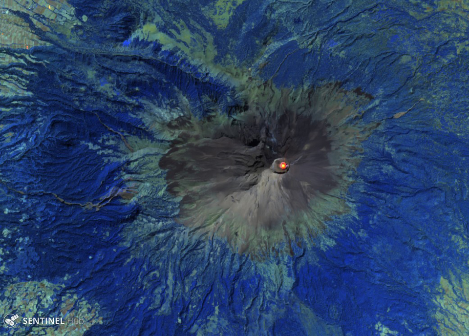 |
Figure 127. A Sentinel-2 satellite image on a clear 16 February 2019 recorded a significant thermal signature from the summit dome of Popocatépetl. Rendering is Atmospheric penetration (bands 12, 11, 8A). Courtesy of Sentinel Hub Playground. |
Satellite instruments recorded a strong SO2 signature from the volcano during 15-18 February (figure 128). Multi-hour periods of harmonic tremor were recorded during 17-19 February, accompanied by gas-and-ash emissions. Ash plume heights were between 1 and 2 km above the crater, and minor ashfall was reported in Tlaxco and Xalostoc in Nativitas, and Hueyotlipan, Amaxac de Guerrero, Tepetitla de Lardizábal, and Texoloc in Tlaxcala, on 18 February. Two overflights on 18 and 19 February confirmed the formation of dome 82 inside the summit crater, estimated to be 200 m in diameter (figure 129).
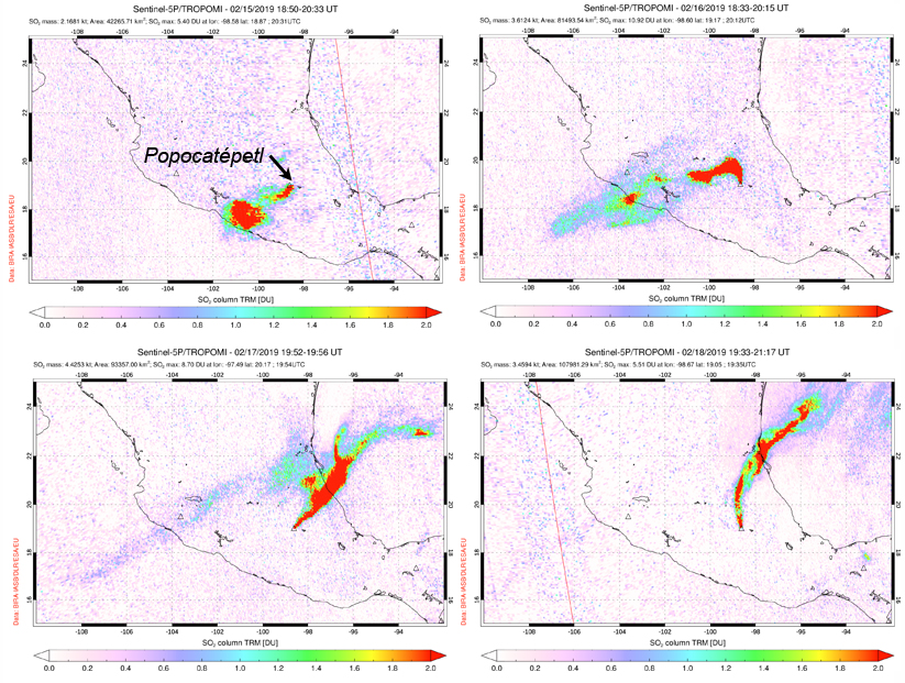 |
Figure 128. Significant SO2 plumes were measured by the TROPOMI instrument on the Sentinel-5P satellite during 15-18 February 2019 at Popocatépetl. The plume initially drifted SW (top left, 15 February); changes in the wind direction carried the plume to the N (top right, 16 February), then to the NE (bottom left, 17 February), and back to the N on 18 February (bottom right). Courtesy of NASA Goddard Space Flight Center. |
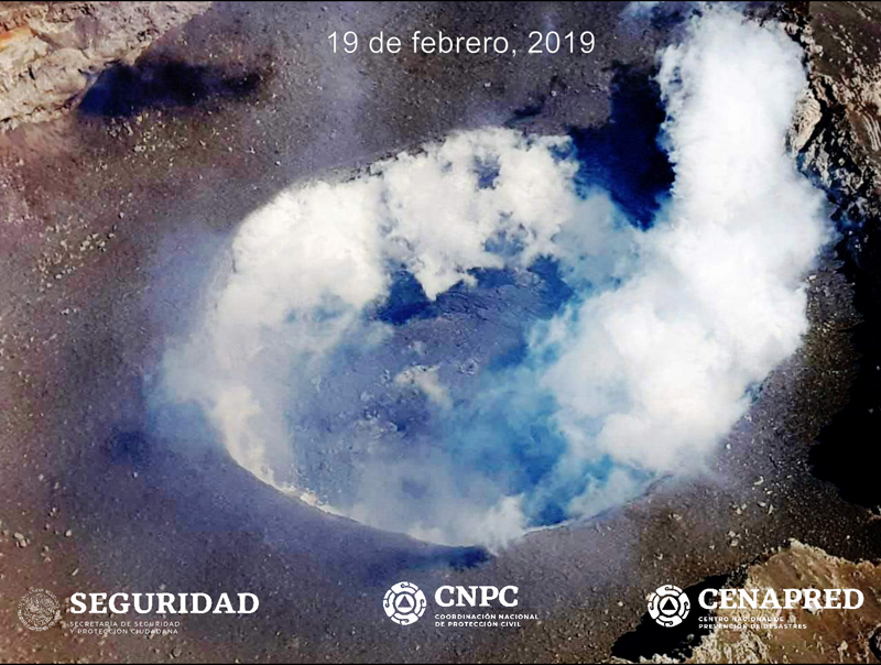 |
Figure 129. An overflight on 19 February by CENAPRED confirmed the formation of dome 82 inside the summit crater at Popocatépetl, estimated to be 200 m in diameter. Courtesy of CENAPRED (Actualización del reporte del monitoreo de CENAPRED al volcán Popocatépetl, 19 de febrero de 2019). |
Geological Summary. Volcán Popocatépetl, whose name is the Aztec word for smoking mountain, rises 70 km SE of Mexico City to form North America's 2nd-highest volcano. The glacier-clad stratovolcano contains a steep-walled, 400 x 600 m wide crater. The generally symmetrical volcano is modified by the sharp-peaked Ventorrillo on the NW, a remnant of an earlier volcano. At least three previous major cones were destroyed by gravitational failure during the Pleistocene, producing massive debris-avalanche deposits covering broad areas to the south. The modern volcano was constructed south of the late-Pleistocene to Holocene El Fraile cone. Three major Plinian eruptions, the most recent of which took place about 800 CE, have occurred since the mid-Holocene, accompanied by pyroclastic flows and voluminous lahars that swept basins below the volcano. Frequent historical eruptions, first recorded in Aztec codices, have occurred since Pre-Columbian time.
Information Contacts: Centro Nacional de Prevención de Desastres (CENAPRED), Av. Delfín Madrigal No.665. Coyoacan, México D.F. 04360, México (URL: http://www.cenapred.unam.mx/); Washington Volcanic Ash Advisory Center (VAAC), Satellite Analysis Branch (SAB), NOAA/NESDIS OSPO, NOAA Science Center Room 401, 5200 Auth Rd, Camp Springs, MD 20746, USA (URL: www.ospo.noaa.gov/Products/atmosphere/vaac, archive at: http://www.ssd.noaa.gov/VAAC/archive.html); MIROVA (Middle InfraRed Observation of Volcanic Activity), a collaborative project between the Universities of Turin and Florence (Italy) supported by the Centre for Volcanic Risk of the Italian Civil Protection Department (URL: http://www.mirovaweb.it/); Sentinel Hub Playground (URL: https://www.sentinel-hub.com/explore/sentinel-playground); Global Sulfur Dioxide Monitoring Page, Atmospheric Chemistry and Dynamics Laboratory, NASA Goddard Space Flight Center (NASA/GSFC), 8800 Greenbelt Road, Goddard, Maryland, USA (URL: https://so2.gsfc.nasa.gov/).