Report on Erta Ale (Ethiopia) — April 2019
Bulletin of the Global Volcanism Network, vol. 44, no. 4 (April 2019)
Managing Editor: Edward Venzke.
Edited by Janine B. Krippner.
Erta Ale (Ethiopia) Continued summit activity and lava flow to the E during April 2018-March 2019
Please cite this report as:
Global Volcanism Program, 2019. Report on Erta Ale (Ethiopia) (Krippner, J.B., and Venzke, E., eds.). Bulletin of the Global Volcanism Network, 44:4. Smithsonian Institution. https://doi.org/10.5479/si.GVP.BGVN201904-221080
Erta Ale
Ethiopia
13.601°N, 40.666°E; summit elev. 585 m
All times are local (unless otherwise noted)
Erta Ale is the most active volcano in Ethiopia, containing multiple active pit craters within both the summit and southeast calderas. Multiple recent lava flows are visible as darker-colored areas on the broad flanks. A new fissure eruption began in January 2017, forming a lava lake and multiple large lava flow fields during January 2017-March 2018. This report summarizes activity during April 2018 through March 2019 and is based on satellite data.
During April 2018 through March 2019 minor activity continued in the calderas and along the active lava flow to the E. Several persistent thermal anomalies were present in both the summit and southeast calderas (figure 88). A small lava outbreak was detected in Sentinel-2 thermal data on 25 December 2018 located approximately 6 km from the vent. Numerous small outbreak flows at the distal end of the lava flow located around 10-15 km away from the vent (figure 89).
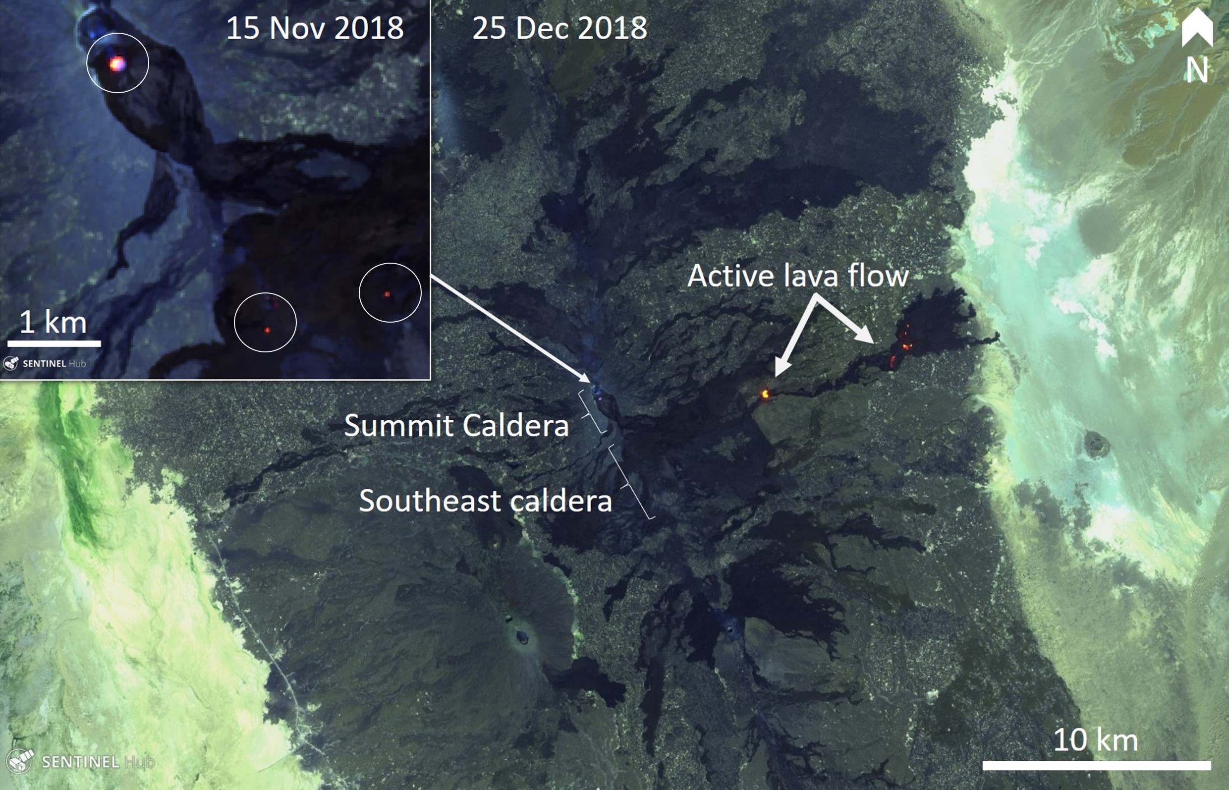 |
Figure 88. Sentinel-2 thermal satellite images showing Erta Ale activity in November and December 2018 with persistent thermal anomalies (bright orange-yellow) in the summit and southeast calderas (circled) and an active lava flow to the E. Courtesy of Sentinel Hub Playground. |
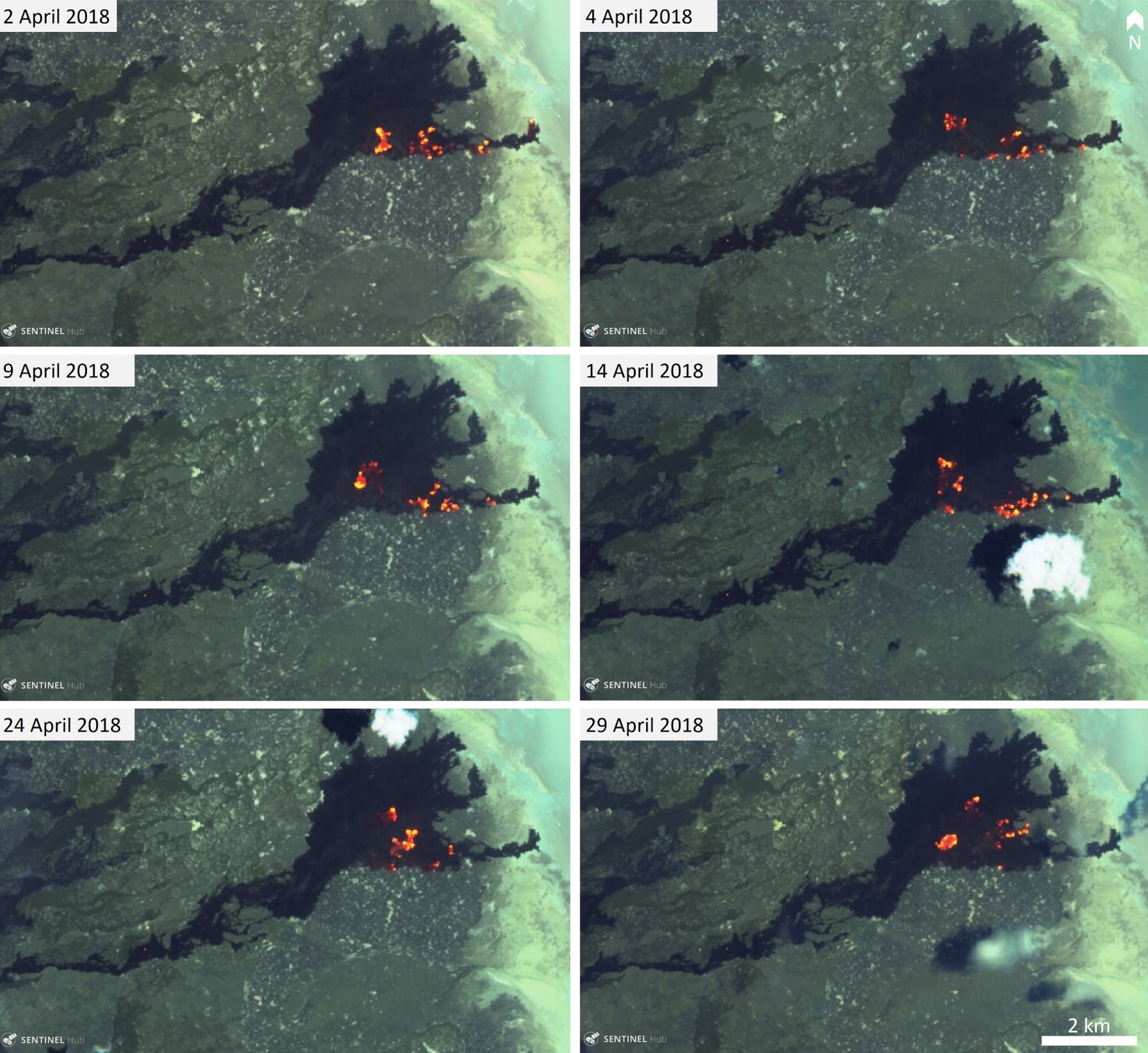 |
Figure 89. Sentinel-2 thermal images showing small lava flow outbreaks (bright orange) in the distal part of the latest Erta Ale flow. Courtesy of Sentinel Hub Playground. |
Thermal activity using MODIS detected by the MIROVA system has been stable with a slight decrease in energy since January 2019 (figure 90). The number of thermal alerts identified by the MODVOLC system was typically below 20/month (figure 91), but with notably lower numbers in April, August, September, and November 2018, and February-March 2019. There were 30 alerts noted in December 2018.
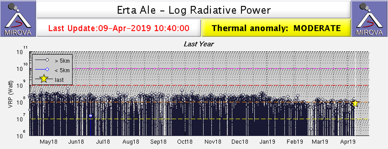 |
Figure 90. Plot showing log radiative power of MODIS infrared data at Erta Ale using the MIROVA algorithm for the year ending 9 April 2019. Black lines indicate that the location of the thermal anomaly is over 5 km from the vent while blue lines indicate that the thermal anomaly is within 5 km of the vent. Courtesy of MIROVA. |
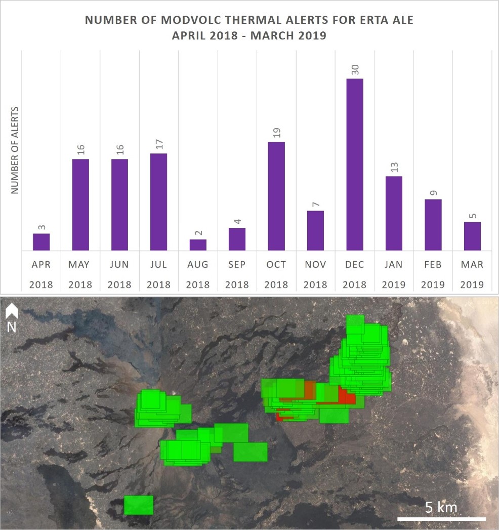 |
Figure 91. Graph showing the number of MODIS thermal alerts in the MODVOLC system for Erta Ale during April 2018-March 2019 (top) and the locations of the thermal alerts (bottom). Data courtesy of HIGP - MODVOLC Thermal Alerts System. |
Sentinel-1 imagery analyzed by Christopher Moore, University of Leeds (Moore et al., in prep, 2019), show a lowering of the lava lake level down to 70-90 m below the rim in October 2018, consistent with broader recent trends. Lava lake activity since late 2014 can be broken down into four stages: the pre-eruption stage during October 2014-January 2017 when the level was stable at less than 20 m below the rim; the initial fissure eruption during 11-28 January 2017 when there was a rapid drop from a state of overflowing down to 80-100 m below the rim; the early stage of the eruption period during January 2017 through mid-2017 when there was a gradual rise up to 50-70 m below the rim; and the late eruption stage during mid-2017 through October 2018 when there was a gradual drop down to 70-90 m below the rim.
Reference: Moore, C., Wright, T., Hooper, A., and Biggs, J., In Prep. Insights into the Shallow Plumbing System of Erta 'Ale Volcano, Ethiopia, from the Long-Lived 2017 Eruption.
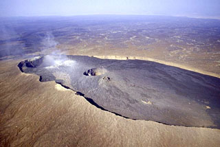
Geological Summary. The Erta Ale basaltic shield volcano in Ethiopia has a 50-km-wide edifice that rises more than 600 m from below sea level in the Danakil depression. The volcano includes a 0.7 x 1.6 km summit crater hosting steep-sided pit craters. Another larger 1.8 x 3.1 km wide depression elongated parallel to the trend of the Erta Ale range is located SE of the summit and is bounded by curvilinear fault scarps on the SE side. Basaltic lava flows from these fissures have poured into the caldera and locally overflowed its rim. The summit caldera usually also holds at least one long-term lava lake that has been active since at least 1967, and possibly since 1906. Recent fissure eruptions have occurred on the N flank.
Information Contacts: MIROVA (Middle InfraRed Observation of Volcanic Activity), a collaborative project between the Universities of Turin and Florence (Italy) supported by the Centre for Volcanic Risk of the Italian Civil Protection Department (URL: http://www.mirovaweb.it/); Hawai'i Institute of Geophysics and Planetology (HIGP) - MODVOLC Thermal Alerts System, School of Ocean and Earth Science and Technology (SOEST), Univ. of Hawai'i, 2525 Correa Road, Honolulu, HI 96822, USA (URL: http://modis.higp.hawaii.edu/); Sentinel Hub Playground (URL: https://www.sentinel-hub.com/explore/sentinel-playground); Christopher Moore, Institute of Geophysics and Tectonics, School of Earth and Environment, University of Leeds, Woodhouse Lane, Leeds, LS2 9JT, United Kingdom (URL: https://environment.leeds.ac.uk/see/pgr/2207/chris-moore).