Kadovar
Papua New Guinea
3.608°S, 144.588°E; summit elev. 365 m
All times are local (unless otherwise noted)
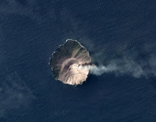
Steeply-sloped Kadovar Island is located about 25 km NNE from the mouth of the Sepik River on the mainland of Papua New Guinea. The first confirmed historical eruption with ash plumes and lava extrusion began in early January 2018, resulting in the evacuation of around 600 residents from the N side of the approximately 1.4-km-diameter island (BGVN 43:03); continuing activity from October 2018 through April 2019 is covered in this report. Information was provided by the Rabaul Volcano Observatory (RVO), the Darwin Volcanic Ash Advisory Center (VAAC), satellite sources, and photos from visiting tourists.
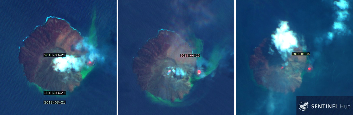
Activity during March-September 2018. After the first recorded explosions with ash plumes in early January 2018, intermittent ash plumes continued through March 2018. A lava flow on the E flank extended outward from the island, extruding from a vent low on the E flank and forming a dome just offshore. The dome collapsed and regrew twice during February 2018; the growth rate slowed somewhat during March. A satellite image from 21 March 2018 was one of the first showing the new dome growing off the E flank with a thermal anomaly and sediment plumes in the water drifting N and E from the area. Thermal anomalies were visible at both the summit vent and the E-flank coastal dome in April and May 2018, along with steam and gas rising from both locations (figure 19).
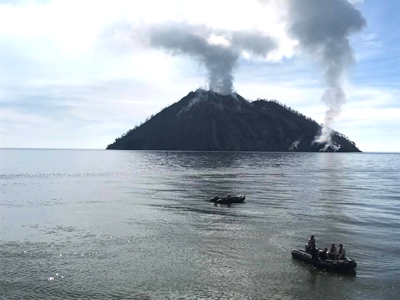
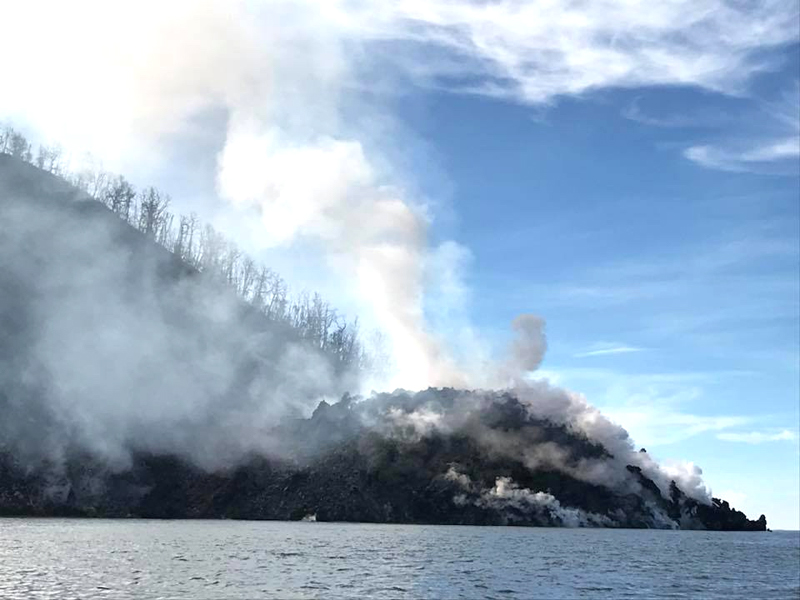
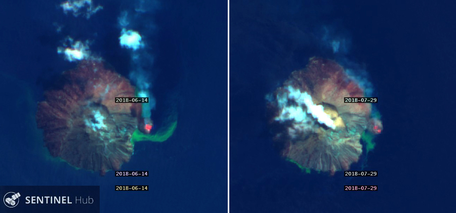
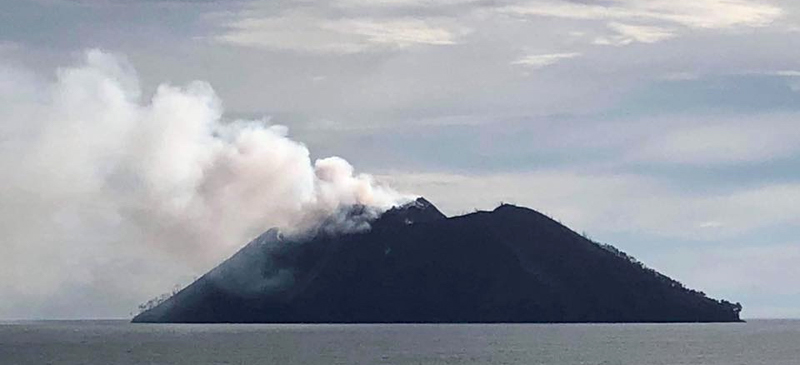
A trip to Kadovar by tourists in mid-May 2018 provided close-up views of the dense steam plumes at the summit and the growing E-flank coastal dome (figures 20 and 21). The thermal anomaly was still strong at the E-flank coastal dome in a mid-June satellite image, but appeared diminished in late July. Intermittent puffs of steam rose from both the summit and the coastal dome in mid-June; the summit plume was much denser on 29 July (figure 22). Ash emissions were reported by the Darwin VAAC and photographed by tourists during June (figure 23) and September 2018 (BGVN 43:10), but thermal activity appeared to decline during that period (figure 24).
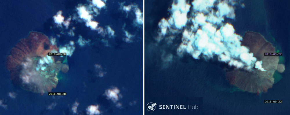
Multiple satellite images during August and early September 2018 showed little or no sign of thermal activity at the E-flank coastal dome, with only intermittent steam plumes from the summit. A new steam plume on the eastern slope appeared in a 22 September 2018 image (figure 25). The Rabaul Volcano Observatory (RVO) reported explosive activity on the afternoon of 21 September. Noises of explosions were accompanied by dark gray and brown ash clouds that rose several hundred meters above the summit crater and drifted NW. Local reports indicated that the activity continued through 26 September and ashfall was reported on Blupblup island during the period. Ground observers noted incandescence visible from both the summit and the E-flank coastal dome.
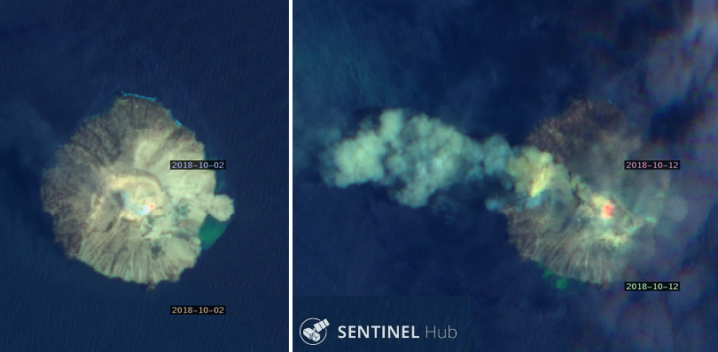
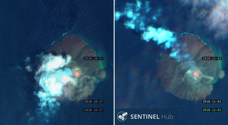
Activity during October-December 2018. Evidence of both thermal and explosive activity reappeared in October 2018 (figure 24). The Darwin VAAC reported intermittent ash plumes rising to 2.7 km altitude and drifting W on 1 October 2018. Low-level continuous ash emissions rising less than a kilometer and drifting W were reported early on 3 October. A higher plume drifted WNW at 2.4 km altitude on 7 October. Intermittent discrete emissions of ash continued daily at that altitude through 16 October, drifting NW or W. Ash emissions drifting NW and thermal anomalies at the summit were visible in satellite imagery on 2 and 12 October (figure 26). A brief ash emission was reported on 21 October 2018 at 2.4 km altitude drifting NE for a few hours. Intermittent ash emissions also appeared on 29 October moving SE at 1.8 km altitude. For the following three days ash drifted SW, W, then NW at 2.1 km altitude, finally dissipating on 1 November; the thermal anomaly at the summit was large and intense in satellite images on 27 October and 1 November compared with previous images (figure 27).
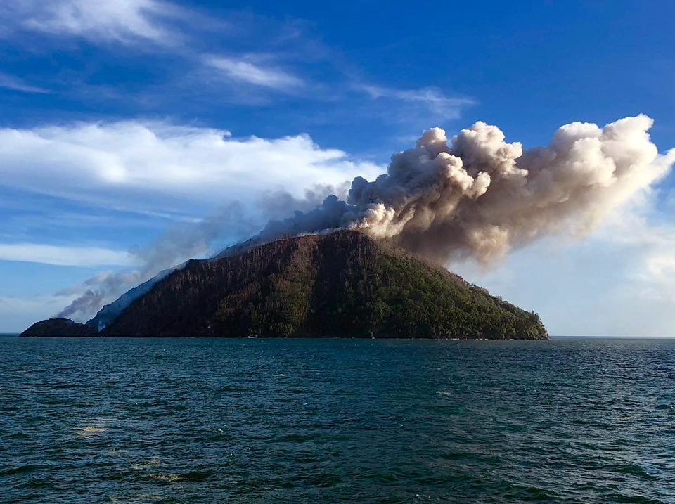
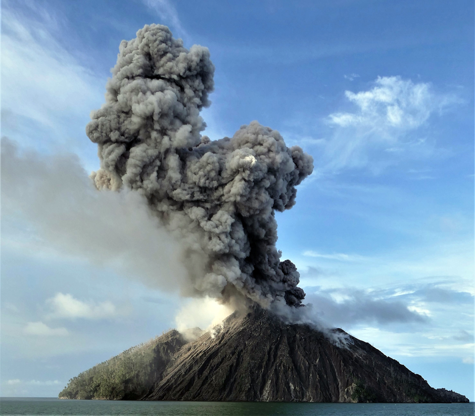
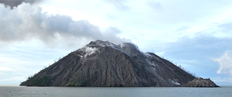
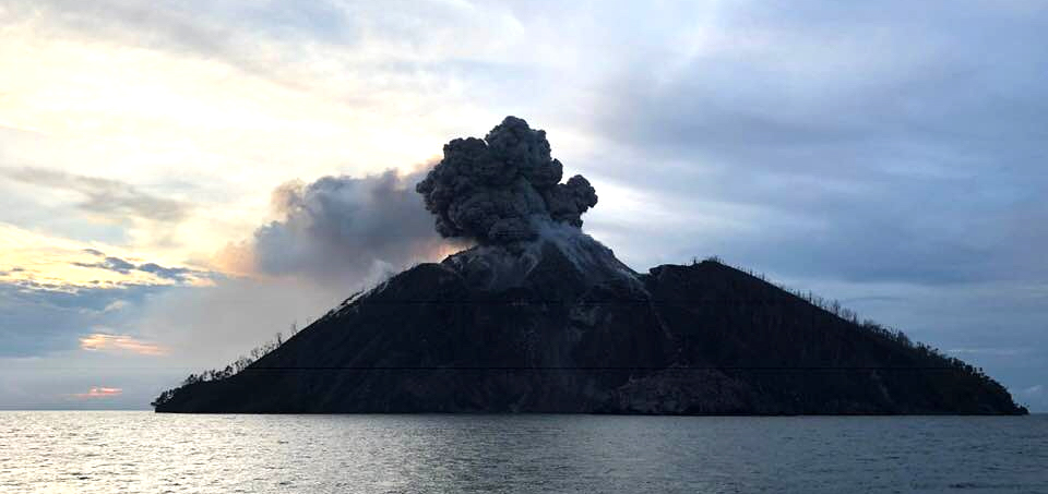
An ash explosion was photographed by tourists on a cruise ship on the afternoon of 6 November 2018 (figure 28). After the explosion, a dense steam plume rose from a large dome of lava near the summit at the top of the E flank (figure 29). Continuous ash emissions rising to 1.8 km altitude were reported by the Darwin VAAC beginning on 9 November 2018 moving WNW and lasting about 24 hours. A new ash plume clearly identifiable on satellite imagery appeared on 13 November at 2.4 km altitude moving E, again visible for about 24 hours. Another shipboard tourist photographed an ash plume on 18 November rising a few hundred meters above the summit (figure 30).
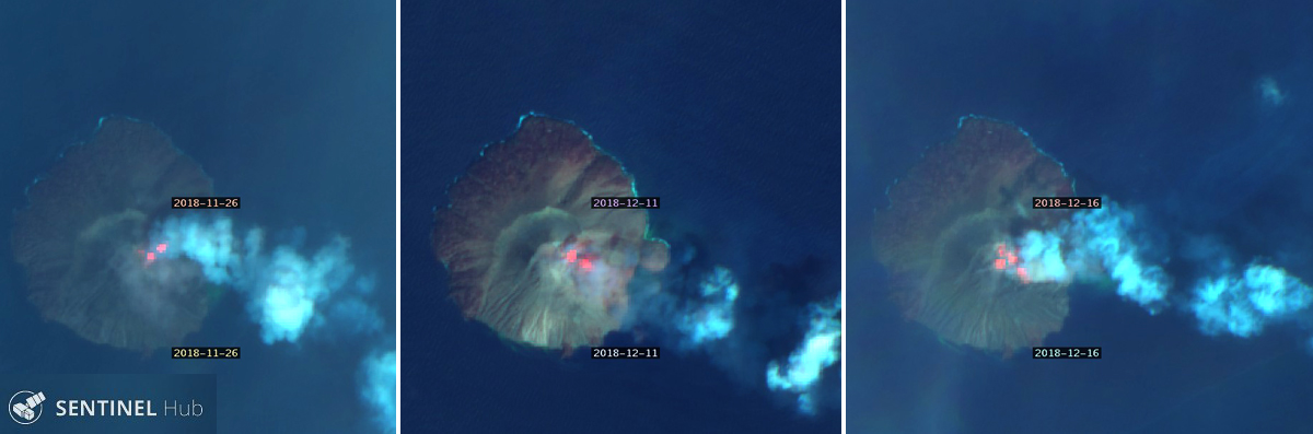
Low-level ash emissions were reported briefly on 28 November at about 1 km altitude moving SE. Intermittent puffs of ash were seen drifting WSW on 2 and 3 December at about 1.2 km altitude. They were the last VAAC reports for 2018. Two thermal anomalies were visible at the summit in satellite imagery on 26 November, they grew larger and more intense through 16 December when multiple anomalies appeared at the summit and on the E flank (figure 31).
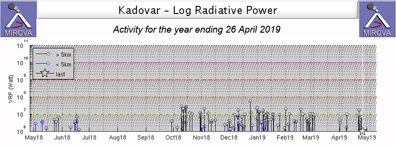
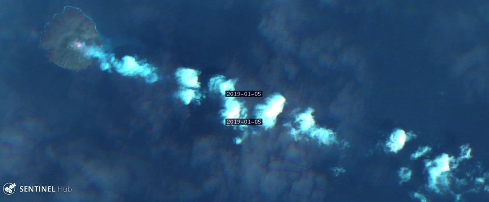
Activity during January-April 2019. Multiple thermal anomalies were still visible at the summit in satellite imagery on 5 January 2019 as regular puffs of steam drifted SE from the summit, leaving a long trail in the atmosphere (figure 32). Additional imagery on 10 and 30 January showed a single anomaly at the summit, even through dense meteorologic clouds. A short-lived ash emission rose to 2.4 km altitude on 11 January 2019 and drifted E; it dissipated the next day. Multiple minor intermittent discrete ash plumes extended WNW at 3.0 km altitude on 18 January; they dissipated within six hours.
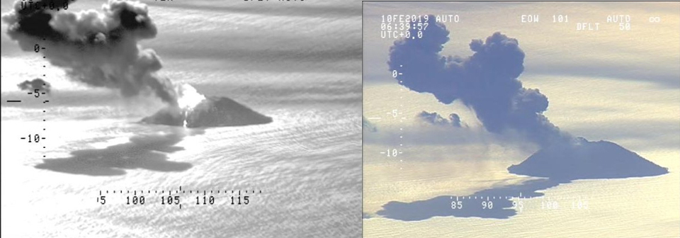
The Royal New Zealand Air Force released images of eruptive activity on 10 February 2019 (figure 33). Satellite imagery in February was largely obscured by weather; two thermal anomalies were barely visible through clouds at the summit on 14 February. The Darwin VAAC reported an ash emission at 1.8 km altitude drifting ESE on 16 February; a similar plume appeared on 21 February that also dissipated in just a few hours.
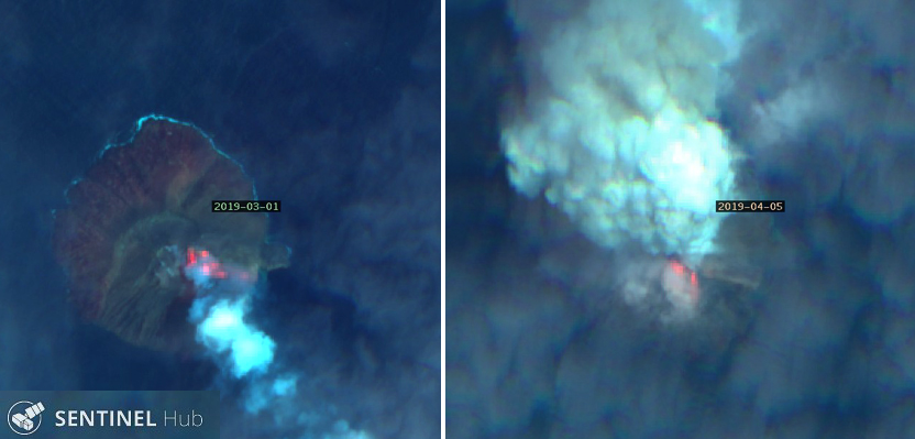
Satellite imagery on 1 March 2019 confirmed a strong thermal anomaly from the summit and down the E flank almost to the coast. A month later on 5 April the anomaly was nearly as strong and a dense ash and steam plume drifted N from the summit (figure 34). A tourist witnessed a dense steam plume rising from the summit on 4 April (figure 35). Multiple discrete eruptions were observed in satellite imagery by the Darwin VAAC on 9 April at 1.2-1.5 km altitude drifting SE. The thermal anomaly at the summit persisted in satellite imagery taken on 15 April 2019.
Geological Summary. The 2-km-wide island of Kadovar is the emergent summit of a Bismarck Sea stratovolcano of Holocene age. It is part of the Schouten Islands, and lies off the coast of New Guinea, about 25 km N of the mouth of the Sepik River. Prior to an eruption that began in 2018, a lava dome formed the high point of the andesitic volcano, filling an arcuate landslide scarp open to the south; submarine debris-avalanche deposits occur in that direction. Thick lava flows with columnar jointing forms low cliffs along the coast. The youthful island lacks fringing or offshore reefs. A period of heightened thermal phenomena took place in 1976. An eruption began in January 2018 that included lava effusion from vents at the summit and at the E coast.
Information Contacts: Rabaul Volcano Observatory (RVO), Geohazards Management Division, Department of Mineral Policy and Geohazards Management (DMPGM), PO Box 3386, Kokopo, East New Britain Province, Papua New Guinea; Sentinel Hub Playground (URL: https://www.sentinel-hub.com/explore/sentinel-playground); MIROVA (Middle InfraRed Observation of Volcanic Activity), a collaborative project between the Universities of Turin and Florence (Italy) supported by the Centre for Volcanic Risk of the Italian Civil Protection Department (URL: http://www.mirovaweb.it/); Tico Liu, Hong Kong (Facebook: https://www.facebook.com/tico.liu. https://www.facebook.com/photo.php?fbid=10155389178192793&set=pcb.10155389178372793&type=3&theater); Shari Kalt (Instagram user LuxuryTravelAdvisor: https://www.instagram.com/luxurytraveladviser/, https://www.instagram.com/p/BkhalnuHu2j/); Coral Expeditions, Australia (URL: https://www.coralexpeditions.com/, Facebook: https://www.facebook.com/coralexpeditions); Philip Stern (Facebook: https://www.facebook.com/sternph, https://www.facebook.com/sternph/posts/2167501866616908); Brad Scott, GNS Science Volcanologist at GNS Science, New Zealand (Twitter: https://twitter.com/Eruptn); Chaiyasit Saengsirirak, Bangkok, Thailand (Facebook: https://www.facebook.com/chaiyasit.saengsirirak, https://www.facebook.com/photo.php?fbid=2197513186969355).