Report on Ambae (Vanuatu) — June 2019

Bulletin of the Global Volcanism Network, vol. 44, no. 6 (June 2019)
Managing Editor: Edward Venzke.
Edited by A. Elizabeth Crafford.
Ambae (Vanuatu) Declining thermal activity and no explosions during February-May 2019
Please cite this report as:
Global Volcanism Program, 2019. Report on Ambae (Vanuatu) (Crafford, A.E., and Venzke, E., eds.). Bulletin of the Global Volcanism Network, 44:6. Smithsonian Institution. https://doi.org/10.5479/si.GVP.BGVN201906-257030
Ambae
Vanuatu
15.389°S, 167.835°E; summit elev. 1496 m
All times are local (unless otherwise noted)
Ambae (Aoba) is a large basaltic shield volcano in the New Hebrides arc, part of the multi-island country of Vanuatu. Its periodic phreatic and pyroclastic explosions originating in the summit crater lakes have been recorded since the 16th century. A pyroclastic cone appeared in Lake Voui during November 2005-February 2006 (BGVN 31:12, figure 30); an explosive eruption from a new pyroclastic cone in the lake began in mid-September 2017 (BGVN 43:02). Activity included high-altitude ash emissions (9.1 km), lava flows, and Strombolian activity. Intermittent pulses of ash emissions during the following months resulted in extensive ashfall and evacuations; multiple communities were affected by lahars. The most recent episode of the eruption from July to September 2018 (BGVN 44:02) resulted in 11-km-altitude ash plumes and the evacuation of the entire island due to heavy ashfall and lahars. This report covers activity from February to May 2019, with information provided by the Vanuatu Geohazards Observatory of the Vanuatu Meteorology and Geo-Hazards Department (VMGD) and satellite data from multiple sources.
Activity diminished after the extensive eruptive phase of July-September 2018 when substantial ash plumes and ashfall resulted in evacuations. An explosion with an ash plume on 30 October 2018 was the last activity reported for 2018. Thermal alerts were reported by the Hawai'i Institute of Geophysics and Planetology (HIGP) MODVOLC thermal alerts system through January 2019, and the Log Radiative Power graph prepared by the MIROVA project showed decreasing thermal anomalies into June 2019 (figure 92). Satellite images recorded in April and May 2019 (figure 93) showed the configuration of the summit lakes to be little changed from the previous November except for the color (BGVN 44:02, figure 89). No ash emissions or SO2 plumes were reported during the period. VMGD noted that the volcano remained at Alert Level 2 through May 2019 with a 2-km-radius exclusion zone around the summit.
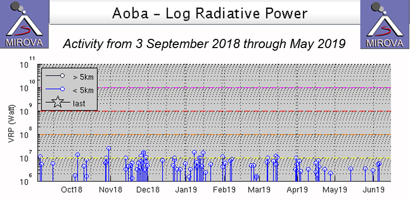 |
Figure 92. The MIROVA log radiative power plot for Ambae showed ongoing intermittent thermal anomalies from early September 2018 through May 2019. Courtesy of MIROVA. |
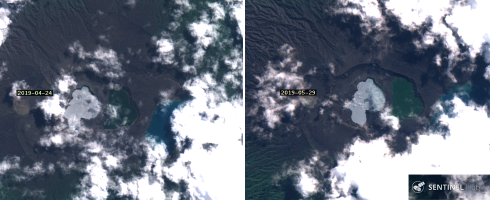 |
Figure 93. Satellite imagery in April and May 2019 showed little change in the configuration of lakes at the summit of Ambae since November 2018 (see BGVN 44:02, figure 89). Left: 24 April 2019. Right: 29 May 2019. Sentinel-2 satellite imagery with "Natural Color" rendering (bands 4, 3, 2); courtesy of Sentinel Hub Playground. |
Geological Summary. The island of Ambae, also known as Aoba, is a massive 2,500 km3 basaltic shield that is the most voluminous volcano of the New Hebrides archipelago. A pronounced NE-SW-trending rift zone with numerous scoria cones gives the 16 x 38 km island an elongated form. A broad pyroclastic cone containing three crater lakes (Manaro Ngoru, Voui, and Manaro Lakua) is located at the summit within the youngest of at least two nested calderas, the largest of which is 6 km in diameter. That large central edifice is also called Manaro Voui or Lombenben volcano. Post-caldera explosive eruptions formed the summit craters about 360 years ago. A tuff cone was constructed within Lake Voui (or Vui) about 60 years later. The latest known flank eruption, about 300 years ago, destroyed the population of the Nduindui area near the western coast.
Information Contacts: Geo-Hazards Division, Vanuatu Meteorology and Geo-Hazards Department (VMGD), Ministry of Climate Change Adaptation, Meteorology, Geo-Hazards, Energy, Environment and Disaster Management, Private Mail Bag 9054, Lini Highway, Port Vila, Vanuatu (URL: http://www.vmgd.gov.vu/, https://www.facebook.com/VanuatuGeohazardsObservatory/); Hawai'i Institute of Geophysics and Planetology (HIGP) - MODVOLC Thermal Alerts System, School of Ocean and Earth Science and Technology (SOEST), Univ. of Hawai'i, 2525 Correa Road, Honolulu, HI 96822, USA (URL: http://modis.higp.hawaii.edu/); MIROVA (Middle InfraRed Observation of Volcanic Activity), a collaborative project between the Universities of Turin and Florence (Italy) supported by the Centre for Volcanic Risk of the Italian Civil Protection Department (URL: http://www.mirovaweb.it/); Sentinel Hub Playground (URL: https://www.sentinel-hub.com/explore/sentinel-playground).