Report on Piton de la Fournaise (France) — July 2019

Bulletin of the Global Volcanism Network, vol. 44, no. 7 (July 2019)
Managing Editor: Edward Venzke.
Edited by A. Elizabeth Crafford.
Piton de la Fournaise (France) Eruptive episodes in February-March and June 2019; multiple fissures and lava flows
Please cite this report as:
Global Volcanism Program, 2019. Report on Piton de la Fournaise (France) (Crafford, A.E., and Venzke, E., eds.). Bulletin of the Global Volcanism Network, 44:7. Smithsonian Institution. https://doi.org/10.5479/si.GVP.BGVN201907-233020
Piton de la Fournaise
France
21.244°S, 55.708°E; summit elev. 2632 m
All times are local (unless otherwise noted)
Short pulses of intermittent eruptive activity have characterized Piton de la Fournaise, the large basaltic shield volcano on La Réunion Island in the western Indian Ocean, for several thousand years. For the last 20 years, frequent effusive basaltic eruptions have occurred on average twice per year. The activity is characterized by lava fountains and lava flows, and occasional explosive eruptions that shower blocks over the summit area and produce ash plumes. Almost all of the recent activity has occurred within the Enclos Fouqué caldera, although past eruptions in 1977, 1986, and 1998 have occurred at vents outside of the caldera. Four separate eruptive episodes were reported during 2018; from 3-4 April, 27 April-1 June, 13 July, and 15 September-1 November (BGVN 43:12, 43:09). Two episodes from 2019 during February-March and June are covered in this report, with information provided primarily by the Observatoire Volcanologique du Piton de la Fournaise (OVPF) as well as satellite instruments.
Piton de la Fournaise experienced two eruptions during November 2018-June 2019. The first lasted from 18 February to 10 March 2019, and the second episode was 11-13 June. The episode in February-March consisted of multiple fissures opening on the E flank of the Dolomieu crater on 18 February with lava flows that traveled several hundred meters. After a brief pause, one new fissure opened nearby on 19 February and produced up to 3 million m3 of lava in a little over four days. Although the flow rate then declined, the eruption continued until 10 March. During the last three days, 7-10 March, two new fissures opened nearby and produced large volumes of lava, bringing the total eruptive volume to about 14.5 million m3. After little activity during April and May, a small eruption occurred on the SSE outer slope of Dolomieu crater that lasted for about 48 hours on 11-13 June; multiple small flows traveled about 1,000 m down the steep flank before ceasing. The MIROVA thermal anomaly graph of log radiative power clearly showed the abruptness of the beginning and ends of the last three eruptive episodes at Piton de la Fournaise from August 2018 through June 2019 (figure 165).
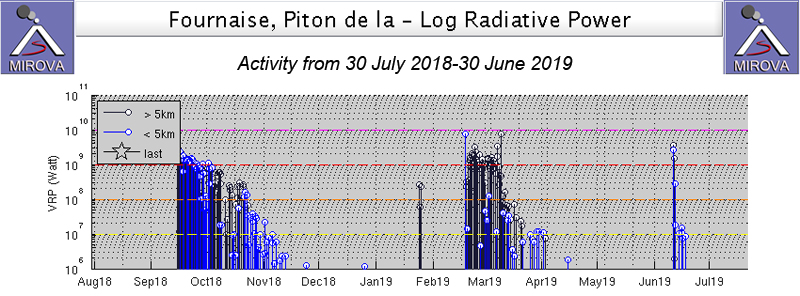 |
Figure 165. The MIROVA graph of thermal energy from Piton de la Fournaise from 30 July 2018 through June 2019 shows the last three eruptive episodes at the volcano. From 15 September through 1 November 2018 fissures and flows were active on the SW flank of Dolomieu crater near Rivals crater (BGVN 43:12). Fissures opened on the E flank of the crater on 18 February 2019, and after a brief pause resumed on 19 February at the foot of Piton Madoré. Lava flows remained active until 10 March 2019. A short episode of lava effusion occurred on 11-12 June 2019 on the SSE outer slope of Dolomieu crater. Courtesy of MIROVA. |
Activity during November 2018-March 2019. Following the end of the 15 September-1 November 2018 eruption, seismic activity immediately below the summit remained low (with only 20 shallow and two deep earthquakes during November). The inflationary signal recorded since the beginning of September stopped, and the OVPF deformation networks did not record any significant deformation. There were 35 shallow earthquakes (0-2 km depth) below the summit crater during December, and one deep earthquake. Only 12 shallow earthquakes and one deep earthquake (greater than 2 km below the surface) were reported in January.
OVPF reported an increase in CO2 concentrations beginning in December 2018, and noted the beginning of inflation on 13 February 2019. A seismic swarm of 379 earthquakes accompanied by minor but rapid deformation (less than 1 cm) was reported on 16 February 2019. A new seismic swarm of 208 earthquakes began early on 18 February with a much larger ground deformation (10 cm of elongation of the summit zone). A volcanic tremor indicative of the arrival of magma near the surface began at 0948 that morning. Webcams indicated that eruptive fissures had opened in the NE part of the Enclos Fouqué caldera. The onset of the eruption was marked by a sudden drop in CO2 flux which then stabilized. The eruptive sites were confirmed visually around 1130. Three fissures with actively flowing lava opened on the E flank of Dolomieu Crater; the fountains of lava were less than 30 m high. The front of the longest flow had reached 1,900 m elevation after one hour. The eruption lasted a little over 12 hours and was over by 2200 that evening; it covered about 150-200 m of the hiking trail to the summit.
Seismicity remained high after the event ended, and at 1500 on 19 February 2019 another seismic swarm of 511 deep earthquakes located under the E flank at about 2.5 km depth occurred. It was not accompanied by a significant amount of deformation. At 1710 tremor signals appeared on the observatory seismographs and the first gas plumes and lava ejection were observed at 1750 and 1912, respectively. During an overflight the next day (20 February), OVPF team members observed the new eruptive site at an elevation of 1,800 m at the foot of Piton Madoré. One fissure and one fountain were active at 0620 on 20 February and the flow front was at 1,300 m elevation (figure 166). During the night of 20-21 February the flow front crossed over the "Grandes Pentes" area in the eastern half of the Enclos Fouque (figure 167).
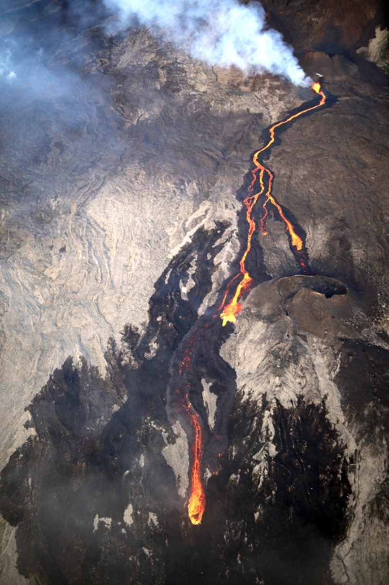 |
Figure 166. The eruption which began on 19 February 2019 on the E flank of Dolomieu crater at Piton de la Fournaise produced a lava fountain and flow which traveled down at least 500 m of elevation by the next morning when this photo was taken at 0620 local time. Courtesy of and copyright by OVPF/IPGP (Bulletin d'activité du mercredi 20 février 2019 à 11h00, Heure locale). |
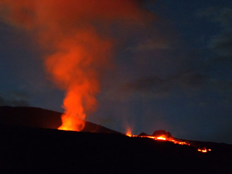 |
Figure 167. The active fissure at Piton de la Fournaise was producing lava fountains and an active flow during the evening of 20 February 2019. Overnight the flow crossed over the "Grandes Pentes" area of the caldera. Photo courtesy of and copyright by OVPF/IPGP (Bulletin d'activité du jeudi 21 février 2019 à 14H00, Heure locale). |
OVPF reported on 22 February 2019 that 22 shallow earthquakes had been reported since the eruption began on 19 February. Surface flow rates estimated from satellite data, via the HOTVOLC system (OPGC - University of Auvergne), were between 2.5 and 15 m3/s. The quantity of lava emitted between 19 and 22 February was between 1 and 3 million m3. OVPF observed the growth of an eruptive cone that was filled with a small lava lake producing ejecta during a morning overflight on 22 February. A channelized flow moved downstream from the cone and split into two lobes about 1 km from (and 200 m below) the cone (figure 168). The split in the flow occurred near the Guyanin crater. The N flowing lobe, about 50 m wide, had an actively flowing front located at 1,320 m elevation; the incandescent flow was travelling over a recent flow (likely from the previous night). The S-flowing lobe spread to 200 m wide and split into two tongues 300 m SE of Guyanin crater.
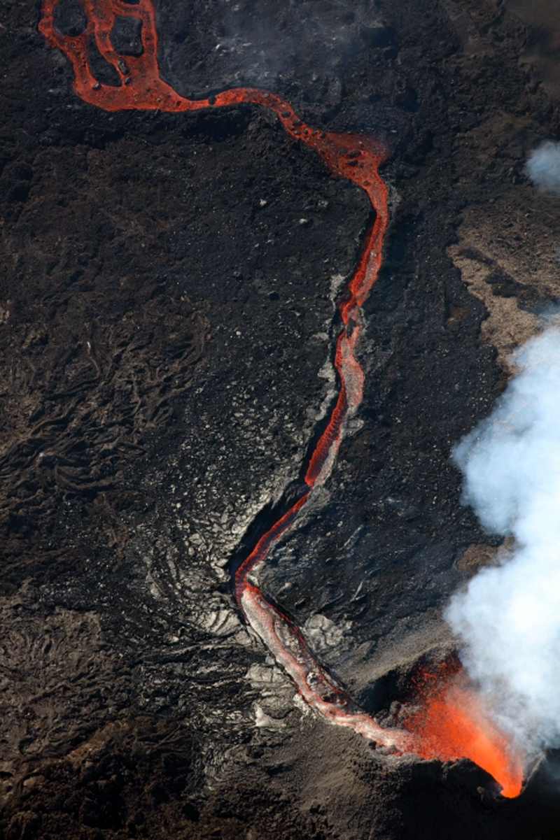 |
Figure 168. During an overflight on the morning of 22 February 2019 scientists from OVPF observed a growing spatter cone with a small lava lake at Piton de la Fournaise. A channelized flow moved downstream from the fissure and split into two flows. Photo courtesy of and copyright by OVPF/IPGP (Bulletin d'activité du vendredi 22 février 2019 à 13h30, Heure locale). |
Incandescent ejecta from the cone was captured in a webcam image overnight on 22-23 February 2019 (figure 169). The rate of advance of the flow slowed significantly by 24 February, but the intensity of the eruptive tremor remained relatively constant. Mapping of the lava flow on 28 February carried out by the OI2 platform (OPGC - University Clermont Auvergne) from satellite data confirmed the slow progress of the flow after 24 February (300 m in 5 days) (figure 170). The flow front was located at 1,200 m elevation, and only the N arm was active; the lava had traveled about 2.2 km from the vent by 28 February.
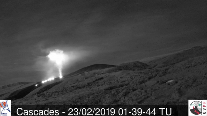 |
Figure 169. Incandescent ejecta from the eruptive cone at Piton de la Fournaise was captured in the webcam in the early hours of 23 February 2019. Courtesy of and copyright by OVPF/IPGP (Bulletin d'activité du samedi 23 février 2019 à 13h30, Heure locale). |
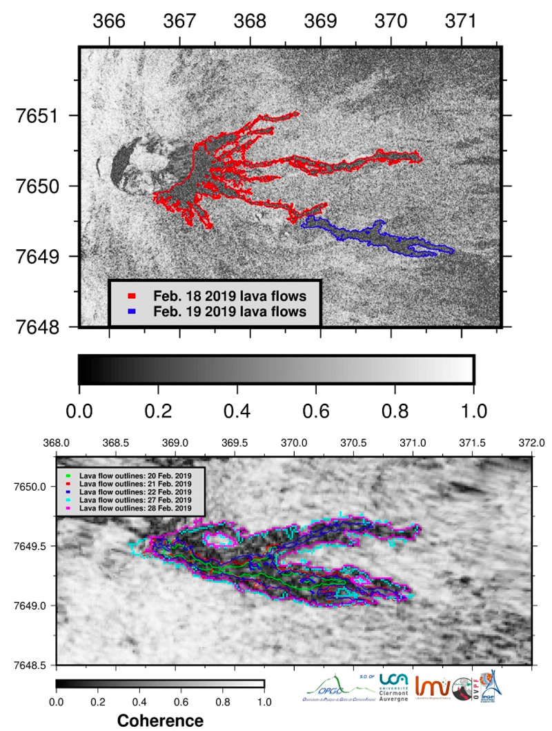 |
Figure 170. Contours of the lava flows at Piton de la Fournaise from 18-28 February 2019 were determined from satellite data by the OI2 platform (Université Clermont Auvergne), dated 18 (red) and 19 (blue) February (top image); 20 (green), 21 (red), 22 (blue), 27 (turquoise), and 28 (pink) February (bottom image). Courtesy of and copyright by OVPF/IPGP. Top: Bulletin d'activité du vendredi 22 février 2019 à 13h30 (Heure locale); bottom: Bulletin d'activité du jeudi 28 février 2019 à 16h30 (Heure locale). |
Between 28 February and 1 March 2019 a third lobe of lava appeared flowing NE from the vent on the N side of the new flow area; it split into two lobes sometime on 1 March. Very little new lava was recorded on the other lobes. By 4 March the flow rate estimated by satellite data was about 7.5 m3/s. During a site visit on the morning of 5 March OVPF scientists sampled the N lobe of the flow and bombs and tephra near the cone, and acquired infrared and visible images. They noted the continued growth of the cone which still had an open vent at the summit and a base 100 m in diameter. It was 25 m high with a 50-m-wide eruptive vent at the top (figure 171). High-temperature gas emissions and strong Strombolian activity issued from the vent. Steam emissions were present around the base of the cone, suggesting the presence of lava tunnels. A single lobe of lava flowed N from the cone.
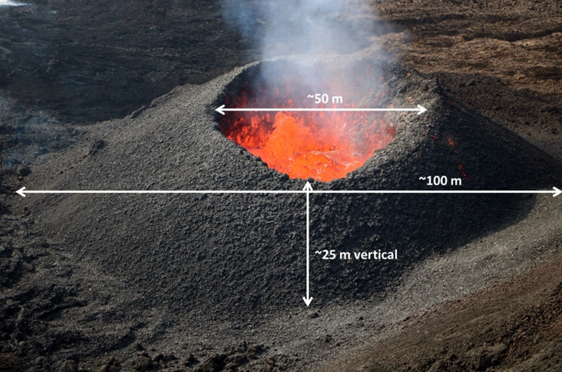 |
Figure 171. The eruptive cone at Piton de la Fournaise on 5 March 2019 had a 100-m-diameter base, 25 m of vertical height, and 50-m-wide vent at the summit. Courtesy of and copyright by OVPF/IPGP, (Bulletin d'activité du mardi 5 mars 2019 à 17h30, Heure locale). |
A new fissure that opened about 150 m from the main vent on the NW flank of Piton Madoré was first observed on the morning of 6 March (figure 172); OVPF concluded that it had opened late on 5 March. A small cone was forming and a new flow traveled N from the main eruptive site. At least six new emission points were noted the following morning (7 March) around the Piton Madoré. Poor weather prevented confirmation by aerial reconnaissance that day, but in a site visit on 8 March OVPF scientists determined that the new fissure from 5 March remained active; a small cone about 10 m high had two flow lobes on the W and N sides (figure 173). A fissure that opened on 7 March was located 300 m S of the 19 February vent and oriented E-W. It was very active on the morning of 8 March with two 50-m-high lava fountains (figure 174). Samples collected by OVPF indicated that the vents of 5 and 7 March produced lava of different compositions.
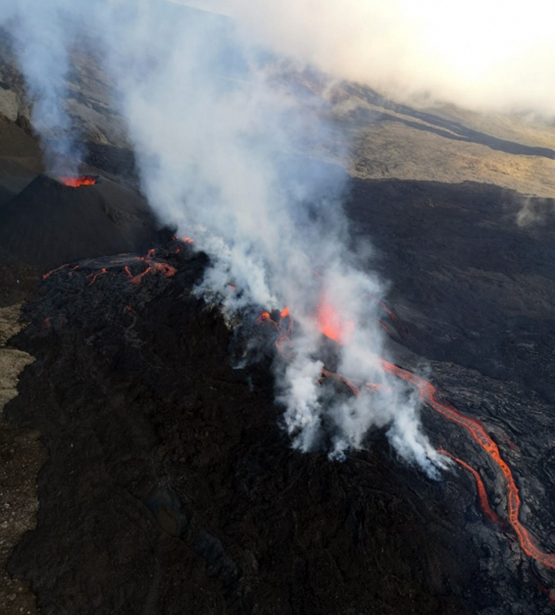 |
Figure 172. A new fissure that opened about 150 m from the main vent on the NW flank of Piton Madoré at Piton de la Fournaise was first observed on the morning of 6 March 2019; OVPF concluded that it had opened late on 5 March. A small cone was forming on the flank of an old one and a new flow traveled N from the main eruptive site. Courtesy of OVPF/IPGP, copyright by Helicopter Coral (Bulletin d'activité du jeudi 7 mars 2019 à 15h00 Heure locale). |
 |
Figure 173. The 5 March 2019 fissure at Piton de la Fournaise on the NW flank of Piton Madoré still had two active flow lobes emerging from it and heading N and W on 8 March 2019. Courtesy of and copyright by OVPF/IPGP (Monthly bulletin of the Piton de la Fournaise Volcanological Observatory, March 2019). |
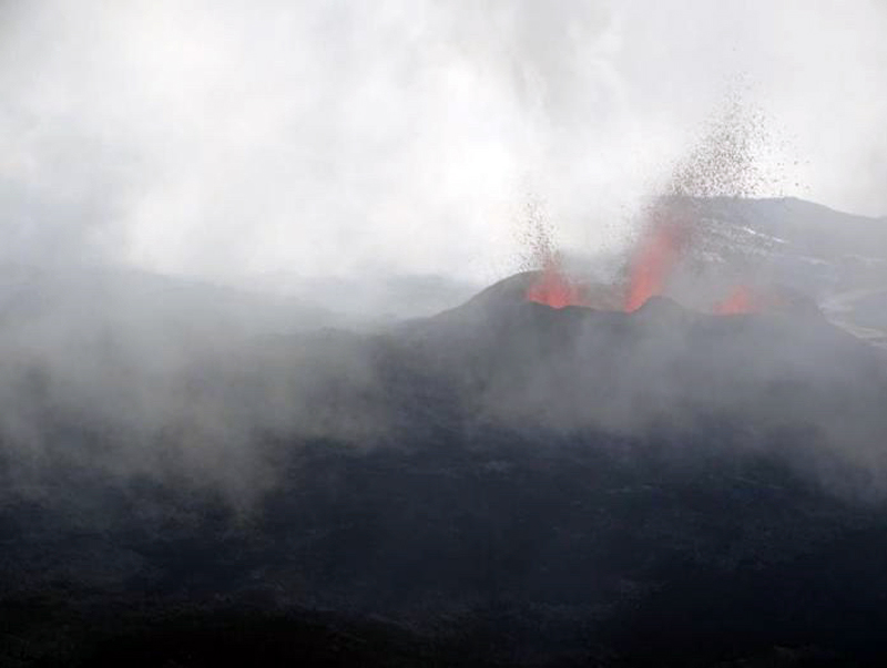 |
Figure 174. A fissure that opened on 7 March 2019 at Piton de la Fournaise was located 300 m S of the 19 February vent and oriented E-W. It was very active on the morning of 8 March 2019 with two 50-m-high lava fountains. Courtesy of and copyright by OVPF/IPGP (Monthly bulletin of the Piton de la Fournaise Volcanological Observatory, March 2019). |
There was a strong increase in the eruptive tremor intensity on 7 March, related to the opening of the two new fissures on 5 and 7 March (figure 175). As a result, the surface flow estimates made from satellite data increased significantly to high values greater than 50 m3/s, with the average values on 7-8 March of around 20-25 m3/s. The increased flow rates resulted in the flows traveling much greater distances. By the morning of 9 March the active flow had reached 650-700 m above sea level. The flow front had traveled about 1 km in 24 hours. Strong seismicity had been increasing under the summit zone for the previous 48 hours. After a phase of very strong surface activity observed overnight on 9-10 March that included lava fountains 50-100 m high (figure 176), surface activity ceased around 0630 on 10 March, and seismic activity decreased significantly. OVPF noted that sudden increases in seismicity and flow rates near the end of an eruption have occurred at about half of the eruptions at Piton de la Fournaise in recent years. Lava volumes emitted on the surface between 18 February and 10 March 2019 were estimated at about 14.5 million m3 (figure 177).
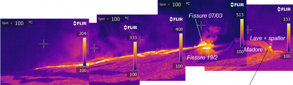 |
Figure 175. An infrared view of the eruptive site on the E flank of Dolomieu crater at Piton de la Fournaise on 8 March 2019 clearly showed the original fissure from 19 February (bottom right of center), the fissure on Piton Madore that opened on 5 March (right) and the fissures that opened on 7 March (upper, right of center). The combined activity produced significant thermal and seismic activity at the volcano. Courtesy of and copyright by OVPF/IPGP (Bulletin d'activité du vendredi 8 mars 2019 à 17h00, Heure locale). |
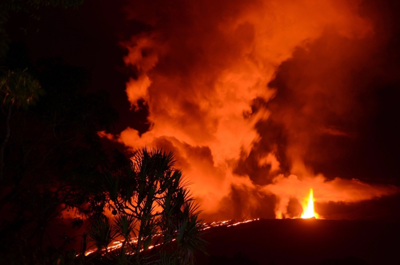 |
Figure 176. Lava fountains 50-100 m high were the result of very strong surface activity observed overnight on 9-10 March 2019 at Piton de la Fournaise. Surface activity ceased around 0630 on 10 March, and seismic activity decreased significantly. Photo taken on 9 March 2019 around midnight from the RN2. Courtesy of OVPF/IPGP, copyright by A. Finizola LGSR/IPGP (Bulletin d'activité du dimanche 10 mars 2019 à 19h30 Heure locale). |
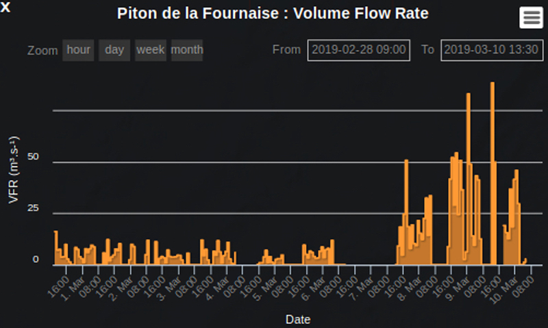 |
Figure 177. A sudden increase in the flow rate at the end of the 18 February-10 March 2019 eruption at Piton de la Fournaise was recorded by researchers at the Université Clermont Auvergne. OVPF noted this was typical of about half of the eruptions at Piton de la Fournaise. Courtesy of OVPF/IPGP, copyright by HOTVOLC, Université Clermont Auvergne (OVPF Monthly bulletin of the Piton de la Fournaise Volcanological Observatory, March 2019). |
Significant SO2 plumes were captured by the TROPOMI instrument on the Sentinel 5-P satellite throughout the 18 February-10 March eruption (figure 178). After the surface eruption ceased, shallow seismicity continued at a lower rate of about 12 earthquakes per day. The end of the eruption (7-10 March) was accompanied by a marked deflation, interpreted by OVPF as the rapid emptying of the magma reservoir. Following the end of the eruption, inflation resumed for the rest of March but then ceased. Seismicity continued at a lower level during April with an average of six shallow earthquakes per day.
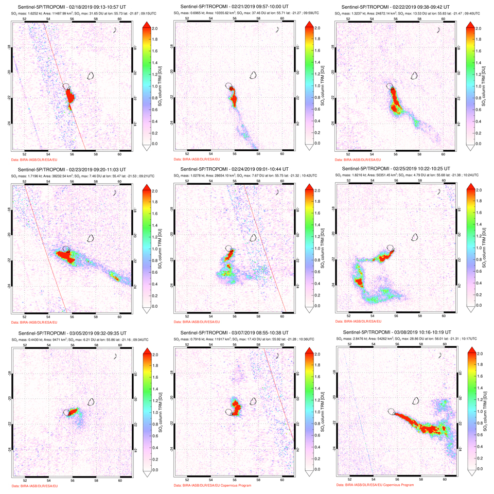 |
Figure 178. Multiple days of high DU value SO2 plumes were recorded by the TROPOMI instrument on the Sentinel 5-P satellite during the 18 February-10 March 2019 eruption at Piton de la Fournaise. Top row: during 18, 21, and 22 February SO2 plumes drifted SE. Middle row: during 23, 24, and 25 February the wind direction changed from SE through S to SW and left a curling trail of SO2. Bottom row: 5, 7, and 8 March showed an increase in SO2 emissions that corresponded with increased seismicity and lava flow output before the eruption ceased. Courtesy of NASA Global Sulfur Dioxide Monitoring Page. |
Activity during May-June 2019. OVPF reported slight inflation near the summit beginning in early May, and an increase in CO2 concentration in the soil near Plaine des Cafres and Plaine des Palmistes. Strong shallow seismicity reappeared on 27 May 2019 and recurred on 30 and 31 May. Two small seismic swarms were measured on 31 May in the early morning. A new seismic swarm beginning at 0603 on 11 June accompanied by rapid deformation suggested a new eruption was imminent. A tremor near the summit area was first noted at 0635 local time; the webcams indicated a plume of gas, but poor visibility prevented evidence of fresh lava. Around 0930 that morning OVPF confirmed that five fissures had opened on the outer SSE slope of Dolomieu crater at elevations ranging from 2480 to 2025 m (figure 179). The flow fronts were not visible due to weather. Lava fountains under 30 m in height and lava flows were present in the three lowest fissures. The flows traveled rapidly down the steep flank of the crater (figure 180).
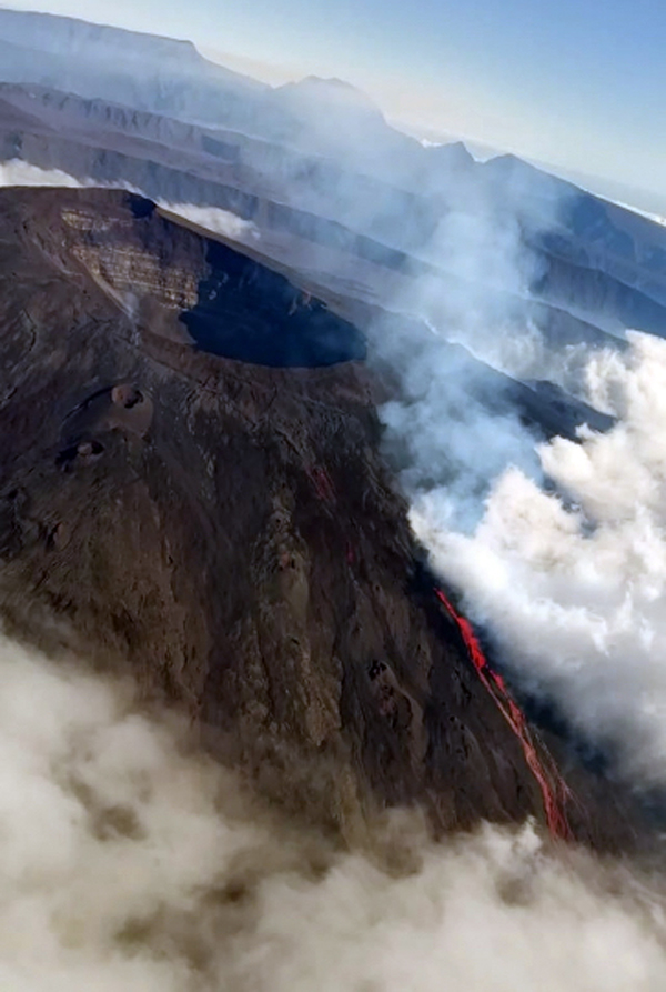 |
Figure 179. Around 0930 on the morning of 11 June 2019 OVPF confirmed that five fissures had opened on the outer SSE slope of Dolomieu crater at Piton de la Fournaise at elevations ranging from 2480 to 2025 m. Courtesy of and copyright by OVPF-IPGP and Imazpress (Bulletin d'activité du mardi 11 juin 2019 à 11h00). |
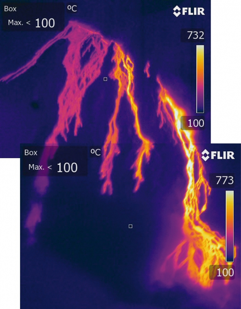 |
Figure 180. Thermal imaging of the 11-12 June 2019 eruptive site at Piton de la Fournaise showed multiple streams of lava traveling rapidly down the steep flank from several fissures on 11 June 2019. Courtesy of and copyright by OVPF-IPGP (Bulletin d'activité du mardi 11 juin 2019 à 11h00). |
The intensity of the eruptive tremor decreased throughout the day, and by 1530 only the lowest elevation fissure was still active (figure 181). The next afternoon (12 June) images in the OVPF webcam located in Piton des Cascades indicated the flow front was at about 1,200-1,300 m elevation. Seismographs indicated that the eruption stopped around 1200 on 13 June. Poor weather obscured visibility of the flow activity. Seismic activity decreased following the eruption, but appeared to increase again beginning on 21 June, with 10 events detected on 30 June. SO2 plumes were recorded in satellite data on 11 and 12 June 2019.
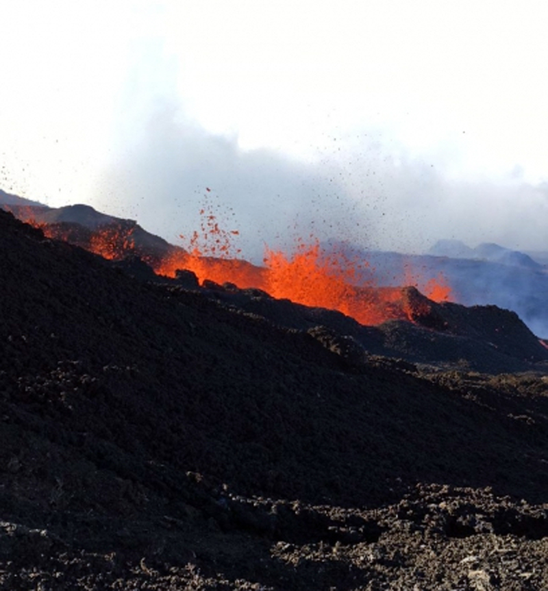 |
Figure 181. The intensity of the eruptive activity at Piton de la Fournaise on 11 June 2019 decreased throughout the day, and by 1530 only the lowest elevation fissure was still active. Courtesy of and copyright by OVPF-IPGP (Bulletin d'activité du mardi 11 juin 2019 à 17h45 Heure locale). |
Geological Summary. Piton de la Fournaise is a massive basaltic shield volcano on the French island of Réunion in the western Indian Ocean. Much of its more than 530,000-year history overlapped with eruptions of the deeply dissected Piton des Neiges shield volcano to the NW. Three scarps formed at about 250,000, 65,000, and less than 5,000 years ago by progressive eastward slumping, leaving caldera-sized embayments open to the E and SE. Numerous pyroclastic cones are present on the floor of the scarps and their outer flanks. Most recorded eruptions have originated from the summit and flanks of Dolomieu, a 400-m-high lava shield that has grown within the youngest scarp, which is about 9 km wide and about 13 km from the western wall to the ocean on the E side. More than 150 eruptions, most of which have produced fluid basaltic lava flows, have occurred since the 17th century. Only six eruptions, in 1708, 1774, 1776, 1800, 1977, and 1986, have originated from fissures outside the scarps.
Information Contacts: Observatoire Volcanologique du Piton de la Fournaise, Institut de Physique du Globe de Paris, 14 route nationale 3, 27 ème km, 97418 La Plaine des Cafres, La Réunion, France (URL: http://www.ipgp.fr/fr); MIROVA (Middle InfraRed Observation of Volcanic Activity), a collaborative project between the Universities of Turin and Florence (Italy) supported by the Centre for Volcanic Risk of the Italian Civil Protection Department (URL: http://www.mirovaweb.it/); Global Sulfur Dioxide Monitoring Page, Atmospheric Chemistry and Dynamics Laboratory, NASA Goddard Space Flight Center (NASA/GSFC), 8800 Greenbelt Road, Goddard, Maryland, USA (URL: https://so2.gsfc.nasa.gov/).