Report on Ibu (Indonesia) — July 2019

Bulletin of the Global Volcanism Network, vol. 44, no. 7 (July 2019)
Managing Editor: Edward Venzke.
Edited by Janine B. Krippner.
Ibu (Indonesia) Frequent ash plumes and small lava flows active in the crater through June 2019
Please cite this report as:
Global Volcanism Program, 2019. Report on Ibu (Indonesia) (Krippner, J.B., and Venzke, E., eds.). Bulletin of the Global Volcanism Network, 44:7. Smithsonian Institution. https://doi.org/10.5479/si.GVP.BGVN201907-268030
Ibu
Indonesia
1.488°N, 127.63°E; summit elev. 1325 m
All times are local (unless otherwise noted)
Ibu volcano on Halmahera island in Indonesia began the current eruption episode on 5 April 2008. Since then, activity has largely consisted of small ash plumes with less frequent lava flows, lava dome growth, avalanches, and larger ash plumes up to 5.5 km above the crater. This report summarizes activity during December 2018 through June 2019 and is based on Volcano Observatory Notice for Aviation (VONA) reports by MAGMA Indonesia, reports by Pusat Vulkanologi dan Mitigasi Bencana Geologi (PVMBG) and Badan Nasional Penanggulangan Bencana (BNPB), and various satellite data.
During December PVMBG reported ash plumes ranging from 200 to 800 m above the crater. There were 11 MODVOLC thermal alerts that registered during 1-12 December. An explosion on 12 January 2019 produced an ash plume that reached 800 m above the crater and dispersed to the S (figure 15). A report released for this event by Sutopo at BNPB said that Ibu had erupted almost every day over the past three months; an example given was of activity on 10 January consisting of 80 explosions. There were four MODVOLC thermal alerts through the month.
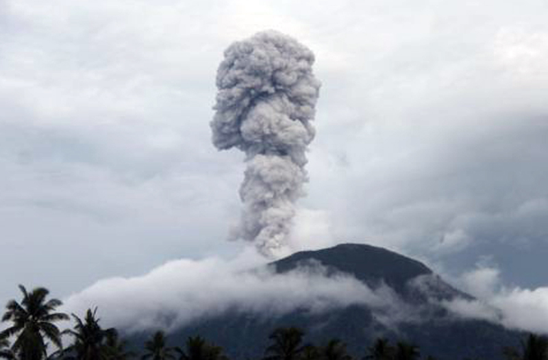 |
Figure 15. An eruption at Ibu at 1712 on 21 January 2019 produced an ash plume that rose to 800 m above the crater. Courtesy of BNPB (color adjusted). |
Throughout February explosions frequently produced ash plumes as high as 800 m above the crater, and nine MODVOLC thermal alerts were issued. Daily reports showed variable plume heights of 200-800 m most days throughout the month. Wind directions varied and dispersed the plumes in all directions. A VONA released at 1850 on 6 February reported an ash plume that rose to 1,925 m altitude (around 600 m above the summit) and dispersed S. Activity continued through March with the Darwin VAAC and PVMBG reporting explosions producing ash plumes to heights of 200-800 m above the crater and dispersing in various directions. There were ten MODVOLC alerts through the month.
Similar activity continued through April, May, and June, with ash plumes reaching 200-800 m above the crater. There were 12, 6, and 15 MODVOLC Alerts in April, May, and June, respectively.
Planet Scope satellite images show activity at a two vents near the center of the crater that were producing small lava flows from February through June (figure 16). Thermal anomalies were frequent during December 2018 through June 2019 across MODVOLC, MIROVA, and Sentinel-2 infrared data (figures 17 and 18). Sentinel-2 data showed minor variation in the location of thermal anomalies within the crater, possibly indicating lava flow activity, and MIROVA data showed relatively constant activity with a few reductions in thermal activity during January and February.
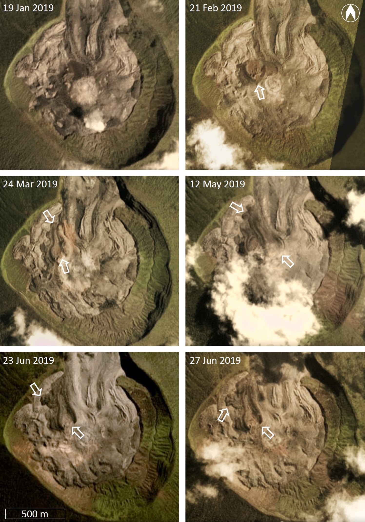 |
Figure 16. Planet Scope natural color satellite images showing activity in the Ibu crater during January through June 2019, with white arrows indicating sites of activity. One vent is visible in the 21 February image, and a 330-m-long (from the far side of the vent) lava flow with flow ridges had developed by 24 March. A second vent was active by 12 May with a new lava flow reaching a maximum length of 520 m. Activity was centered back at the previous vent by 23-27 June. Natural color Planet Scope Imagery, copyright 2019 Planet Labs, Inc. |
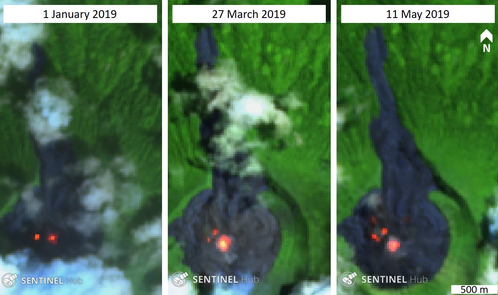 |
Figure 17. Examples of thermal activity in the Ibu crater during January through May 2019. These Sentinel-2 satellite images show variations in hot areas in the crater due to a vent producing a small lava flow. Sentinel-2 false color (urban) images (bands 12, 11, 4) courtesy of Sentinel Hub Playground. |
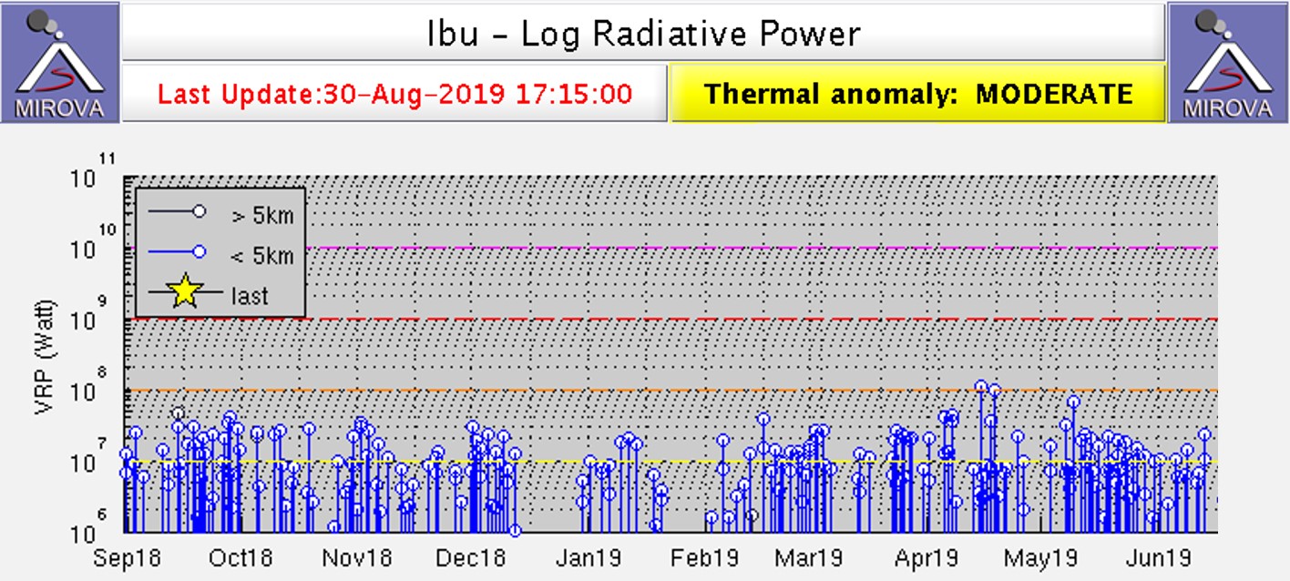 |
Figure 18. MIROVA log radiative power plot of MODIS thermal infrared at Ibu from September 2018 through June 2019. The registered energy was relatively stable through December, with breaks in January and February. Regular thermal anomalies continued with slight variation through to the end of June. Courtesy of MIROVA. |
Geological Summary. The truncated summit of Gunung Ibu stratovolcano along the NW coast of Halmahera Island has large nested summit craters. The inner crater, 1 km wide and 400 m deep, has contained several small crater lakes. The 1.2-km-wide outer crater is breached on the N, creating a steep-walled valley. A large cone grew ENE of the summit, and a smaller one to the WSW has fed a lava flow down the W flank. A group of maars is located below the N and W flanks. The first observed and recorded eruption was a small explosion from the summit crater in 1911. Eruptive activity began again in December 1998, producing a lava dome that eventually covered much of the floor of the inner summit crater along with ongoing explosive ash emissions.
Information Contacts: Pusat Vulkanologi dan Mitigasi Bencana Geologi (PVMBG, also known as Indonesian Center for Volcanology and Geological Hazard Mitigation, CVGHM), Jalan Diponegoro 57, Bandung 40122, Indonesia (URL: http://www.vsi.esdm.go.id/); Badan Nasional Penanggulangan Bencana (BNPB), National Disaster Management Agency, Graha BNPB - Jl. Scout Kav.38, East Jakarta 13120, Indonesia (URL: http://www.bnpb.go.id/); MAGMA Indonesia, Kementerian Energi dan Sumber Daya Mineral (URL: https://magma.vsi.esdm.go.id/); Darwin Volcanic Ash Advisory Centre (VAAC), Bureau of Meteorology, Northern Territory Regional Office, PO Box 40050, Casuarina, NT 0811, Australia (URL: http://www.bom.gov.au/info/vaac/); Hawai'i Institute of Geophysics and Planetology (HIGP) - MODVOLC Thermal Alerts System, School of Ocean and Earth Science and Technology (SOEST), Univ. of Hawai'i, 2525 Correa Road, Honolulu, HI 96822, USA (URL: http://modis.higp.hawaii.edu/); MIROVA (Middle InfraRed Observation of Volcanic Activity), a collaborative project between the Universities of Turin and Florence (Italy) supported by the Centre for Volcanic Risk of the Italian Civil Protection Department (URL: http://www.mirovaweb.it/); Sentinel Hub Playground (URL: https://www.sentinel-hub.com/explore/sentinel-playground); Planet Labs, Inc. (URL: https://www.planet.com/).