Report on Saunders (United Kingdom) — August 2019
Bulletin of the Global Volcanism Network, vol. 44, no. 8 (August 2019)
Managing Editor: Edward Venzke.
Edited by A. Elizabeth Crafford.
Saunders (United Kingdom) Intermittent activity most months, October 2018-June 2019; photographs during February and May 2019
Please cite this report as:
Global Volcanism Program, 2019. Report on Saunders (United Kingdom) (Crafford, A.E., and Venzke, E., eds.). Bulletin of the Global Volcanism Network, 44:8. Smithsonian Institution. https://doi.org/10.5479/si.GVP.BGVN201908-390090
Saunders
United Kingdom
57.8°S, 26.483°W; summit elev. 843 m
All times are local (unless otherwise noted)
Historical observations of eruptive activity from the glacier-covered Mount Michael stratovolcano on Saunders Island in the South Sandwich Islands were not recorded until the early 19th century at this remote site in the southernmost Atlantic Ocean, and remain extremely rare. With the advent of satellite observation technology, indications of more frequent eruptive activity have become apparent. Vapor emission is frequently reported from the summit crater, and AVHRR and MODIS satellite imagery has revealed evidence for lava lake activity in the summit crater (Lachlan-Cope and others, 2001). Limited thermal anomaly data and satellite imagery indicated at least intermittent activity during May 2000-November 2013, and from November 2014 through April 2018 (Gray and others, 2019). Ongoing observations, including photographs from two site visits in February and May 2019 suggest continued activity at the summit during most months through May 2019, the period covered in this report. Information, in addition to on-site photographs, comes from MIROVA thermal anomaly data, NASA SO2 instruments, and Sentinel-2 and Landsat satellite imagery.
Near-constant cloud coverage for much of the year makes satellite data intermittent and creates difficulty in interpreting the ongoing nature of the activity. Gray and others (2019) concluded recently after a detailed study of shortwave and infrared satellite images that there was continued evidence for the previously identified lava lake on Mount Michael since January 1989. MIROVA thermal anomaly data suggest intermittent pulses of thermal energy in September, November, and December 2018, and April 2019 (figure 17). Satellite imagery confirmed some type of activity, either a dense steam plume, evidence of ash, or a thermal anomaly, each month during December 2018-March 2019. Sulfur dioxide anomalies were recorded in January, February, and March 2019. Photographic evidence of fresh ash was captured in February 2019, and images from May 2019 showed dense steam rising from the summit crater.
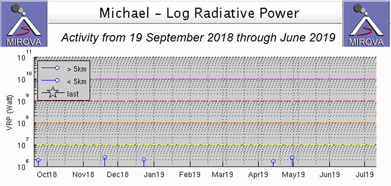 |
Figure 17. MIROVA thermal anomaly data from 19 September 2018 through June 2019 showed sporadic, low-level pulses of thermal energy in late September, November, and December 2018, and April 2019. Courtesy of MIROVA. |
After satellite imagery and thermal anomaly data in late September 2018 showed evidence for eruptive activity (BGVN 43:10, figure 16), a single thermal anomaly in MIROVA data was recorded in mid-November 2018 (figure 17). A rare, clear Sentinel-2 image on 2 December revealed a dense steam plume over the active summit crater; the steam obscured the presence of any possible thermal anomalies beneath (figure 18).
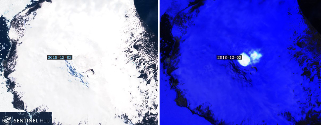 |
Figure 18. Sentinel-2 images of Mount Michael on Saunders Island on 2 December 2018 revealed a dense steam plume over the summit crater that was difficult to distinguish from the surrounding snow in Natural Color rendering (bands 4,3,2) (left), but was clearly visible in Atmospheric Penetration rendering (bands 12,11, 8a) (right). Courtesy of Sentinel Hub Playground. |
Clear evidence of recent activity appeared on 1 January 2019 with both a thermal anomaly at the summit crater and a streak of ash on the snow (figure 19). Steam was also present within the summit crater. A distinct SO2 anomaly appeared in data from the TROPOMI instrument on 14 January (figure 20).
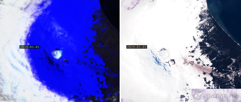 |
Figure 19. A thermal anomaly and dense steam were recorded at the summit of Mount Michael on Saunders Island on 1 January 2019 in Sentinel-2 Satellite imagery with Atmospheric Penetration rendering (bands 12, 11, 8a) (left). The same image shown with Natural Color rendering (bands 4,3,2) (right) shows a recent streak of brown particulates drifting SE from the summit crater. Courtesy of Sentinel Hub Playground. |
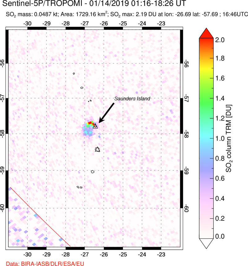 |
Figure 20. A distinct SO2 plume was recorded drifting NW from Saunders Island by the TROPOMI instrument on the Sentinel 5-P satellite on 14 January 2019. Courtesy of NASA Goddard Space Flight Center. |
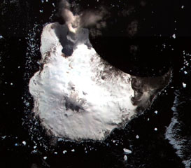
Multiple sources of satellite data and sea-based visual observation confirmed activity during February 2019. SO2 emissions were recorded with the TROPOMI instrument on 10, 11, 15, and 16 February (figure 21). A Landsat image from 10 February showed a dense steam plume drifting NW from the summit crater, with the dark rim of the summit crater well exposed (figure 22). Sentinel-2 images in natural color and atmospheric penetration renderings identified a dense steam plume drifting S and a thermal anomaly within the summit crater on 15 February (figure 23). An expedition to the South Sandwich Islands between 15 February and 8 March 2019 sponsored by the UK government sailed by Saunders in late February and observed a stream of ash on the NNE flank beneath the cloud cover (figure 24).
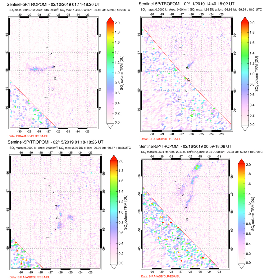 |
Figure 21. Faint but distinct SO2 plumes were recorded drifting away from Saunders Island in various directions on 10, 11, 15, and 16 February 2019. Courtesy of NASA Goddard Space Flight Center. |
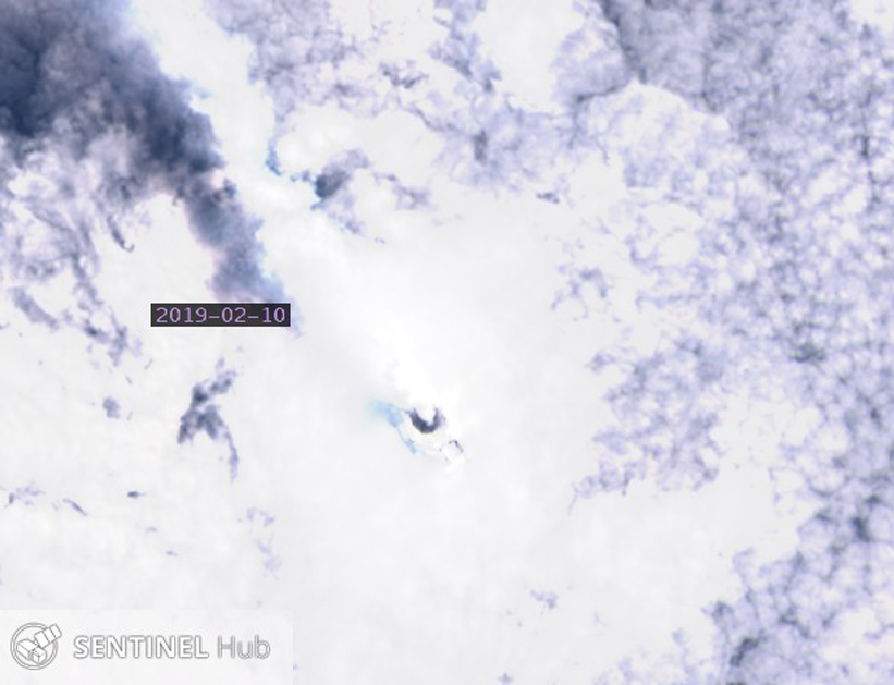 |
Figure 22. The dark summit crater of Mount Michael on Saunders Island was visible in Landsat imagery on 10 February 2019. A dense steam plume drifted NW and cast a dark shadow on the underlying cloud cover. Courtesy of Sentinel Hub Playground. |
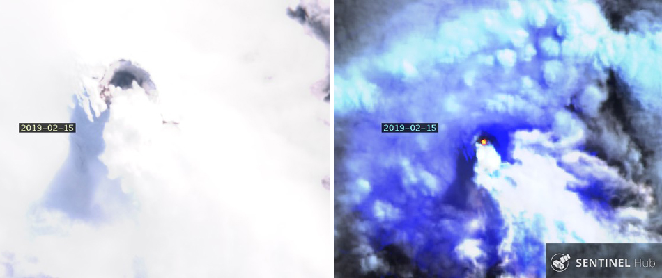 |
Figure 23. At the summit of Mount Michael on Saunders Island, Sentinel-2 images in Natural Color (bands 4,3,2) (left) and Atmospheric Penetration (bands 12, 11, 8a) (right) renderings identified a dense steam plume drifting S and a thermal anomaly within the summit crater on 15 February 2019. Courtesy of Sentinel Hub Playground. |
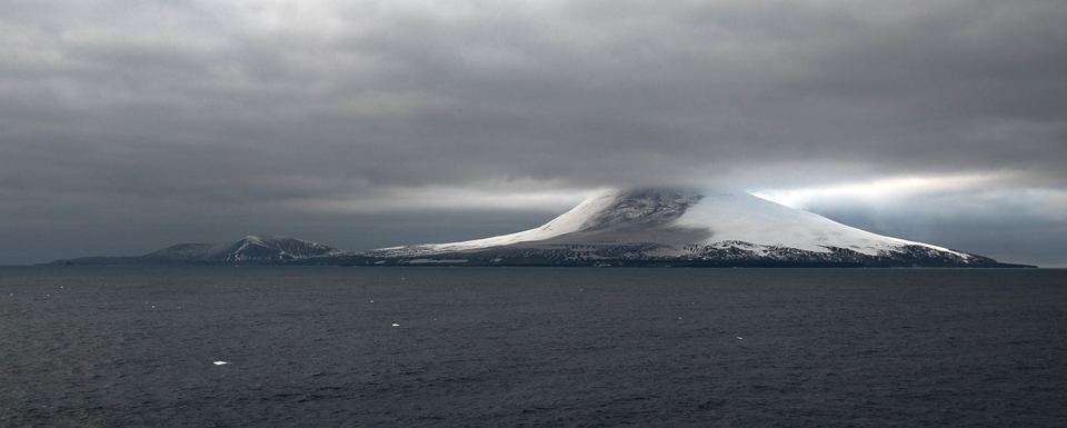 |
Figure 24. Recent ash covered the NNE flank of Mount Michael on Saunders Island in late February 2019 when observed by an expedition to the South Sandwich Islands sponsored by the UK government. Courtesy of Chris Darby. |
Faint SO2 emissions were recorded twice during March 2019 (figure 25), and a dense steam plume near the summit crater was visible in Landsat imagery on 23 March (figure 26). Two thermal anomalies were captured in the MIROVA data during April 2019 (figure 17).
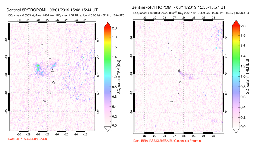 |
Figure 25. Faint SO2 plumes were recorded on 1 and 11 March 2019 emerging from Saunders Island. Courtesy of NASA Goddard Space Flight Center. |
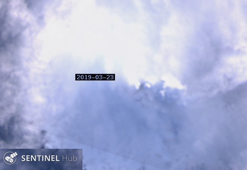 |
Figure 26. A dense steam plume drifted E from the summit crater of Mount Michael at Saunders Island on 25 March 2019. Landsat-8 image courtesy of Sentinel Hub Playground. |
A volcano-related research project "SSIVOLC" explored the South Sandwich Islands volcanoes during 15 April-31 May 2019. A major aim of SSIVOLC was to collect photogrammetric data of the glacier-covered Mount Michael (Derrien and others, 2019). A number of still images were acquired on 17 and 22 May 2019 showing various features of the island (figures 27-30). The researchers visually observed brief, recurrent, and very weak glow at the summit of Mount Michael after dark on 17 May, which they interpreted as reflecting light from an active lava lake within the summit crater.
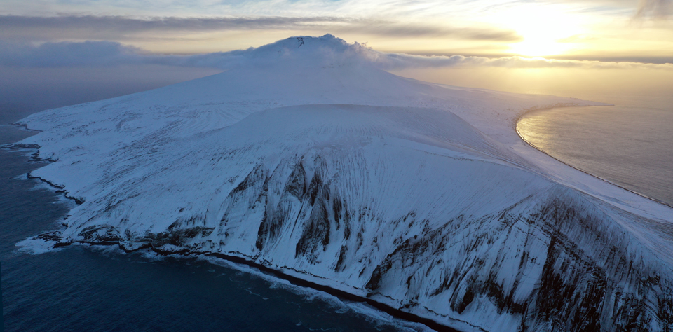 |
Figure 27. The steep slopes of an older eroded crater on the E end of Saunders island in the 'Ashen Hills' shows layers of volcanic deposits dipping away from the open half crater. In the background, steam and gas flow out of the summit crater of Mount Michael and drift down the far slope. Drone image PA-IS-03 taken during 17-22 May 2019, courtesy of Derrien and others (2019) used under Creative Commons Attribution 4.0 International (CC-BY 4.0) License. |
 |
Figure 28. A dense steam plume drifts away from the summit of Mount Michael on Saunders Island in this drone image taken during 17-22 May 2019. The older summit crater is to the left of the dark patch in the middle of the summit. North is to the right. Image SU-3 courtesy of Derrien and others (2019) used under Creative Commons Attribution 4.0 International (CC-BY 4.0) License. |
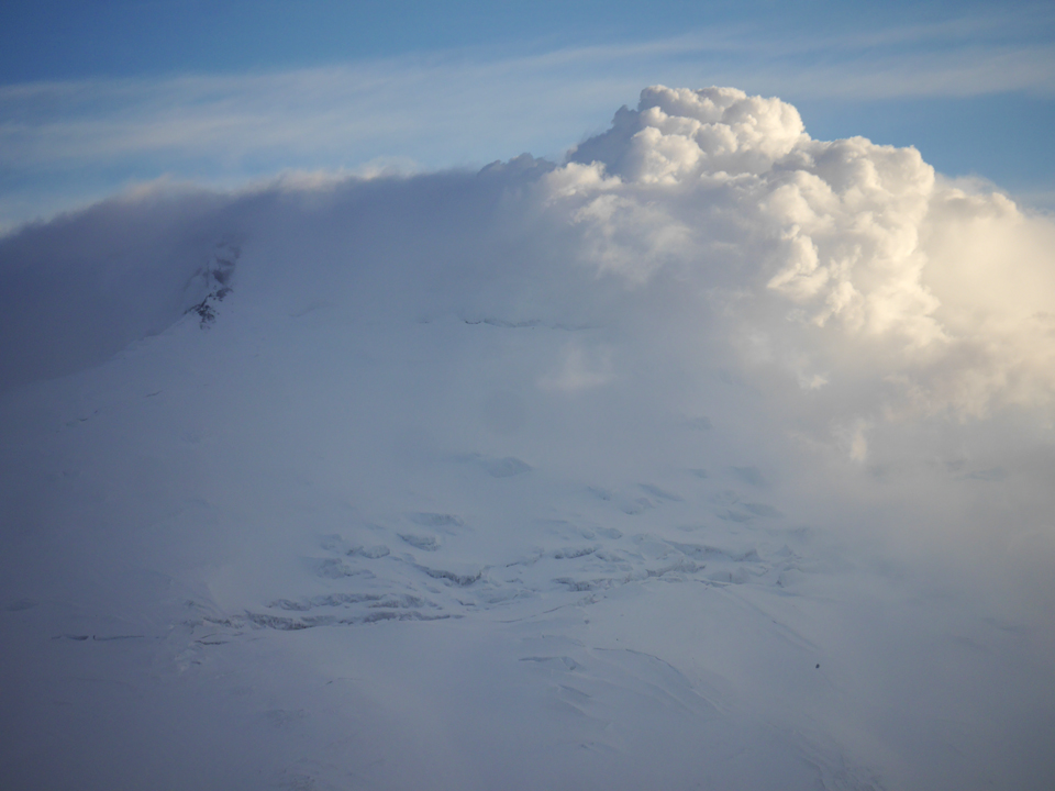 |
Figure 29. This close-up image of the summit of Mount Michael on Saunders Island shows steam plumes billowing from the summit crater, and large crevasses in the glacier covered flank, taken during 17-22 May 2019. The old crater is to the left. Image TL-SU-1 courtesy of Derrien and others (2019) used under Creative Commons Attribution 4.0 International (CC-BY 4.0) License. |
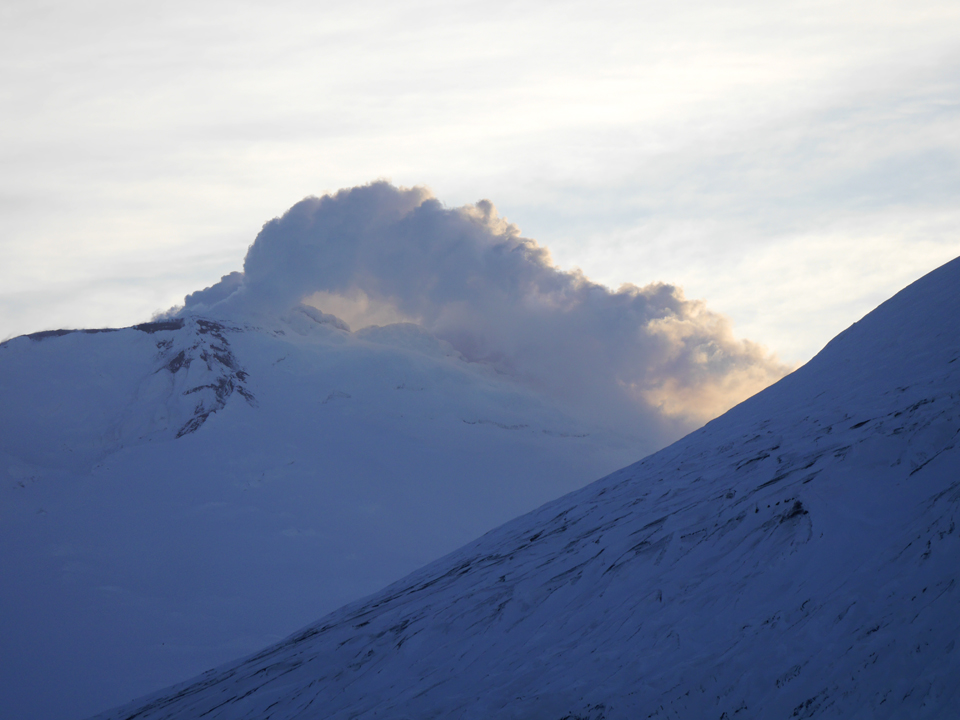 |
Figure 30. A dense plume of steam rises from the summit crater of Mount Michael on Saunders Island and drifts over mounds of frozen material during 17-22 May 2019. The older crater is to the left, and part of the Ashen Hills is in the foreground. Image TL-SU-2 courtesy of Derrien and others (2019) used under Creative Commons Attribution 4.0 International (CC-BY 4.0) License. |
References: Lachlan-Cope T, Smellie J L, Ladkin R, 2001. Discovery of a recurrent lava lake on Saunders Island (South Sandwich Islands) using AVHRR imagery. J. Volcanol. Geotherm. Res., 112: 105-116.
Gray D M, Burton-Johnson A, Fretwell P T, 2019. Evidence for a lava lake on Mt. Michael volcano, Saunders Island (South Sandwich Islands) from Landsat, Sentinel-2 and ASTER satellite imagery. J. Volcanol. Geotherm. Res., 379:60-71. https://doi.org/10.1016/j.volgeores.2019.05.002.
Derrien A, Richter N, Meschede M, Walter T, 2019. Optical DSLR camera- and UAV footage of the remote Mount Michael Volcano, Saunders Island (South Sandwich Islands), acquired in May 2019. GFZ Data Services. http://doi.org/10.5880/GFZ.2.1..2019.003
Geological Summary. Saunders Island consists of a large central volcanic edifice intersected by two seamount chains, as shown by bathymetric mapping (Leat et al., 2013). The young Mount Michael stratovolcano dominates the glacier-covered island, while two submarine plateaus, Harpers Bank and Saunders Bank, extend north. The symmetrical Michael has a 500-m-wide summit crater and a remnant of a somma rim to the SE. Tephra layers visible in ice cliffs surrounding the island are evidence of recent eruptions. Ash clouds were reported from the summit crater in 1819, and an effusive eruption was inferred to have occurred from a N-flank fissure around the end of the 19th century and beginning of the 20th century. A low ice-free lava platform, Blackstone Plain, is located on the north coast, surrounding a group of former sea stacks. A cluster of cones on the SE flank, the Ashen Hills, appear to have been modified since 1820 (LeMasurier and Thomson, 1990). Analysis of satellite imagery available since 1989 (Gray et al., 2019; MODVOLC) suggests frequent eruptive activity (when weather conditions allow), volcanic clouds, steam plumes, and thermal anomalies indicative of a persistent, or at least frequently active, lava lake in the summit crater. Due to this observational bias, there has been a presumption when defining eruptive periods that activity has been ongoing unless there is no evidence for at least 10 months.
Information Contacts: MIROVA (Middle InfraRed Observation of Volcanic Activity), a collaborative project between the Universities of Turin and Florence (Italy) supported by the Centre for Volcanic Risk of the Italian Civil Protection Department (URL: http://www.mirovaweb.it/); Global Sulfur Dioxide Monitoring Page, Atmospheric Chemistry and Dynamics Laboratory, NASA Goddard Space Flight Center (NASA/GSFC), 8800 Greenbelt Road, Goddard, Maryland, USA (URL: https://so2.gsfc.nasa.gov/); Sentinel Hub Playground (URL: https://www.sentinel-hub.com/explore/sentinel-playground); Chris Darby (URL: https://twitter.com/ChrisDDarby, image at https://twitter.com/ChrisDDarby/status/1100686838568812544).