Report on Piton de la Fournaise (France) — November 2019

Bulletin of the Global Volcanism Network, vol. 44, no. 11 (November 2019)
Managing Editor: Edward Venzke.
Edited by A. Elizabeth Crafford.
Piton de la Fournaise (France) Three brief eruptive events in July, August, and October 2019
Please cite this report as:
Global Volcanism Program, 2019. Report on Piton de la Fournaise (France) (Crafford, A.E., and Venzke, E., eds.). Bulletin of the Global Volcanism Network, 44:11. Smithsonian Institution. https://doi.org/10.5479/si.GVP.BGVN201911-233020
Piton de la Fournaise
France
21.244°S, 55.708°E; summit elev. 2632 m
All times are local (unless otherwise noted)
Short pulses of intermittent eruptive activity have been common at Piton de la Fournaise, the large basaltic shield volcano on La Réunion Island in the western Indian Ocean, for several thousand years. Over the last 20 years effusive basaltic eruptions have occurred on average twice per year. The activity is characterized by lava fountains and lava flows, and occasional explosive eruptions that shower blocks over the summit area and produce ash plumes. Almost all of the recent activity has occurred within the Enclos Fouqué caldera around the flanks of the central cone which has the Dolomieu Crater at its summit, although past eruptions in 1977, 1986, and 1998 have occurred at vents outside the caldera. Two eruptive episodes were reported during January-June 2019; from 18 February to 10 March, and from 11 to 13 June (BGVN 44:07). Three episodes during July-October 2019 are covered in this report, with information provided primarily by the Observatoire Volcanologique du Piton de la Fournaise (OVPF) as well as satellite instruments.
Three brief eruptive episodes took place during July-October 2019. In each case, slow ground inflation in the weeks leading up to the eruption was followed by sudden inflation at the time of the fissure opening and lava flow event. This was followed by a resumption of inflation days or weeks later. The first event took place during 29-30 July and consisted of three fissures opening on the N flank of the Dolomieu cone. It lasted for less than 24 hours, and the maximum flow length was about 730 m. The second event began on 11 August with two fissures opening on the S flank of the Dolomieu cone. The flows traveled downhill almost 3 km; activity ended on 15 August. Two new fissures opened during 25-27 October on the SSE flank of the cone; one was active only briefly while the second created a 3.6-km-long flow that stopped a few hundred meters before the major highway. The sudden surges of thermal energy from the eruptions are clearly visible in the MIROVA thermal data (figure 182). Each of the eruptive episodes was also accompanied by SO2 emissions that were detected by satellite instruments (figure 183).
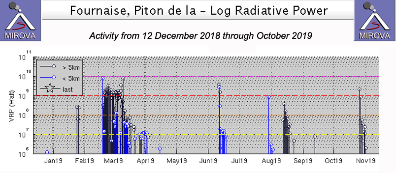 |
Figure 182. Three eruptive events took place at Piton de la Fournaise during July-October 2019 and appear as spikes in thermal activity during 29-30 July, 11-15 August, and 25-27 October. Additional events in late February-early March and mid-June are also visible in this MIROVA graph of thermal energy from 12 December 2018 through October 2019. Courtesy of MIROVA. |
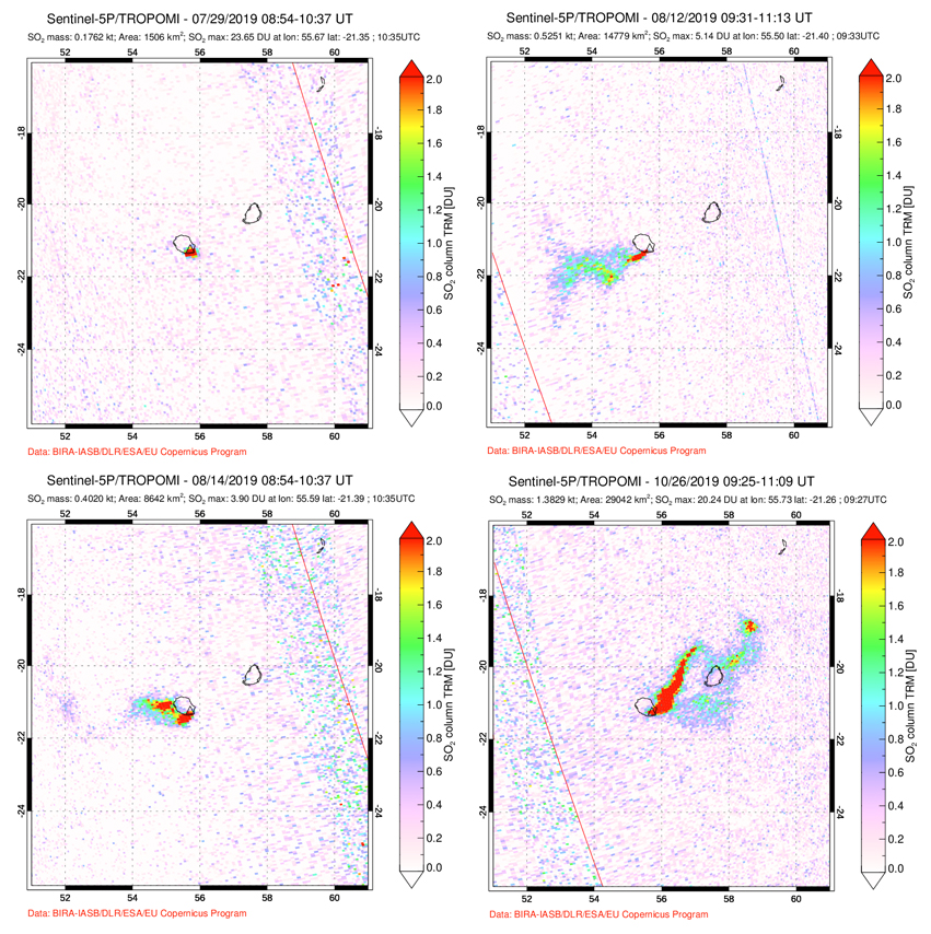 |
Figure 183. Sulfur dioxide emissions were measured from Piton de la Fournaise during each of the eruptive events that occurred in July (top left), August (top right and bottom left), and October (bottom right) 2019. Courtesy of NASA Goddard Space Flight Center. |
Activity during July 2019. The last eruption, a series of flows from several fissures on the SSE flank of Dolomieu Crater near the crater rim (at the center of the Enclos Fouqué caldera), lasted from 11 to 13 June 2019 (figure 184). Ground deformation after the eruption indicated renewed inflation of the edifice which had been ongoing since May. OVPF reported an increase in seismicity beginning on 21 June which continued throughout July; the earthquakes were located near the NW rim of the Dolomieu Crater and on its NW flank. Four centimeters of elongation were recorded between two GNSS stations within the Enclos during late June and July prior to the next eruption. The next short-lived eruption took place during 29-30 July, near the location of the seismicity on the NW flank of the Dolomieu cone about 600 m E of the Formica Leo cone. The onset of the eruption was accompanied by rapid ground deformation of about 12-13 cm, recorded at a station that is located west of the Dolomieu Crater (figure 185).
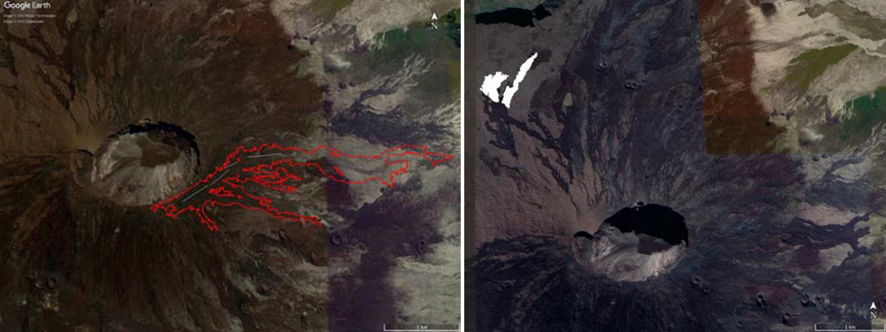 |
Figure 184. Location maps of lava flows formed during the 11-13 June 2019 (left) and 29-30 July 2019 (right) eruptions at Piton de la Fournaise. Information derived from satellite data via the OI2 platform and aerial photos. Lava flows from June are shown as red polygons and eruptive fissures are shown as white lines. For the July event, the flows are shown in white. Courtesy of OVPF, OI2 and Université Clermont Auvergne (Monthly bulletins of the Piton de la Fournaise Volcanological Observatory, June and July 2019). |
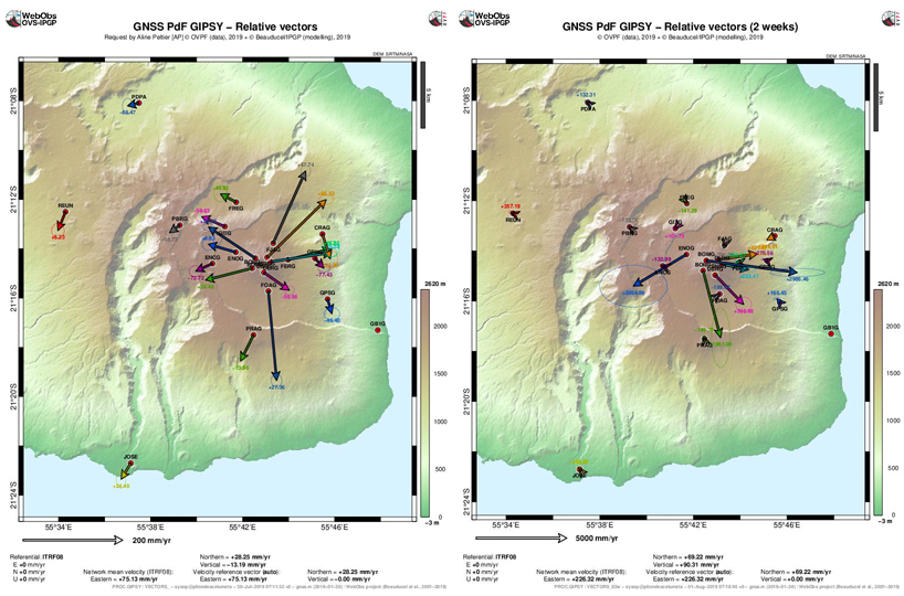 |
Figure 185. Horizontal surface displacements indicating inflation of Piton de la Fournaise of about four centimeters were gradual between 14 June and 28 July 2019 (left). Just prior to and at the onset of the eruption on 29 July, a much greater displacement of about 12 cm occurred, associated with the subsurface ascent of magma (right). Courtesy of OVPF-IPGP (Monthly bulletin of the Piton de la Fournaise Volcanological Observatory, July 2019). |
The late July eruption began around 1200 local time on 29 July 2019 with the opening of three fissures over a distance of about 450 m on the N flank of Dolomieu cone, close to the tourist trail to the summit (figure 186). Lava fountains 20-30 m high were reported. Thermal measurements indicated flow temperatures of about 1,100°C at the base of the lava fountains; samples were collected for analysis (figure 187). Average discharge rates of 11.6 m3s were estimated for the eruption which ended less than 24 hours later, around 0430 on 30 July. The maximum flow length was about 730 m.
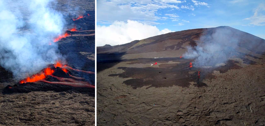 |
Figure 186. Three fissures opened at Piton de la Fournaise on 29 July 2019 and flows traveled 730 m downslope before stopping the next day. The fissures were located on the N flank of Dolomieu cone. Courtesy of OVPF-IPGP, Imaz PressRéunion, and Réunion La 1ère (Monthly bulletin of the Piton de la Fournaise Volcanological Observatory, July 2019). |
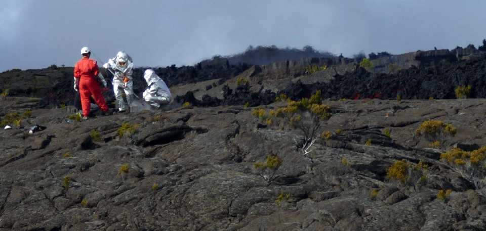 |
Figure 187. Samples were collected for analysis by OVPF from the 29 July 2019 flow at Piton de la Fournaise. Courtesy of OVPF-IPGP (Monthly bulletin of the Piton de la Fournaise Volcanological Observatory, July 2019). |
Eruption of 11-15 August 2019. During 1-10 August there were 33 shallow volcano-tectonic (VT) earthquakes located under the SE flank of Dolomieu cone; a new eruption began over this area on 11 August (figure 188). Two centimeters of inflation were recorded between the 29-30 July eruption and the 11-15 August event; this was followed by a rapid burst of inflation (tens of centimeters) at the onset of the eruption. Inflation resumed shortly after the eruption ended. The eruption began around 1620 local time on 11 August. Two fissures opened, one at 1,700 m elevation, and one at 1,500 m elevation on the SE flank, about 1,400 m apart (figure 189). Due to the steep slopes in the area, the lava flow quickly reached the "Grande Pentes" area before slowing down at the flatter "Piton Tremblet" area. The farthest traveled flow was cooling at an elevation of about 560 m, about 2 km from the National Road (RN2) on 14 August. The maximum effusion rate was measured at 9 m3/s. The eruption stopped on 15 August 2019 at 2200 local time after more than 6 hours of "piston gas" activity, and a brief pause in flow activity earlier in the day. About 3 million m3of lava were emitted, according to OVPF-IPGP. The flows from the 1,700 m and 1500 m altitude fissures reached maximum lengths of 2.9 and 2.7 km, respectively.
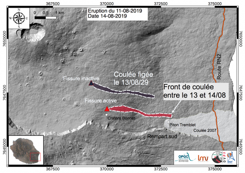 |
Figure 188. Locations of eruptive fissures that opened on 11 August 2019 on the SE flank of Dolomieu cone at Piton de la Fournaise, and the approximate locations of the associated flows. Courtesy of IVPF-IPGP / OPGC-LMV (Bulletin d'activité du mercredi 14 août 2019 à 15h30, Heure locale). |
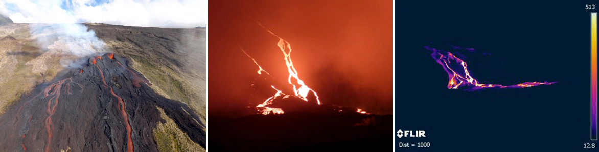 |
Figure 189. Lava flows from the Piton de la Fournaise eruption of 11-15 August 2019 emerged from two fissures on the SE flank of Dolomieu cone. The flows were both active on 13 August (left) at around 0930 local time. Visual and thermal images of the lava flows on 14 August at around 2100 local time (center and right) showed them continuing down the steep slope of the cone and spreading out over the shallower area below. Courtesy of OVPF-IPGP, LMV-OPGC (Monthly bulletin of the Piton de la Fournaise Volcanological Observatory, August 2019). |
Activity during September-October 2019. Very little activity was reported during September 2019. Seismicity remained low with only 32 earthquakes reported during the month, and inflation, which had continued after the 11-15 August eruption, stopped at the beginning of September. Inflation resumed on 11 October. Two seismic swarms were recorded during October 2019. The first, on 21 October (207 events), lasted for about 40 minutes, and did not result in an eruption. The second began on 25 October and consisted of 827 events. It was followed by an eruption during 25-27 October located on the SSE flank of the Dolomieu cone. Deformation followed a similar pattern as it had during and prior to the eruptive events of July and August. Inflation of a few centimeters between 11 and 24 October was followed by rapid inflation of about 10 cm at the onset of the new eruption. Inflation resumed again after this eruption as well.
Two fissures opened during the 25-27 October eruption, one at 1,060 m elevation and one at 990 m. The first fissure was no longer active when viewed during an overflight 2.5 hours after it had opened. The flows moved rapidly until reaching the lower slope areas of the Grand Brule about 1.5-2 km downstream of the "Piton Tremblet" area. On 26 October only one vent was active with fountains 10-20 m high (figure 190). The lava discharge rates during the eruption averaged about 14 m3/s. The eruption ended at 1630 local time on 27 October after one hour of "gas piston" activity (figure 191). A total of about 1.8 million m3 of lava was emitted. The flows from the 990 m elevation site reached a maximum length of 3.6 km, and the lava flow front stopped about 230 m before reaching the RN2 National road (figure 192).
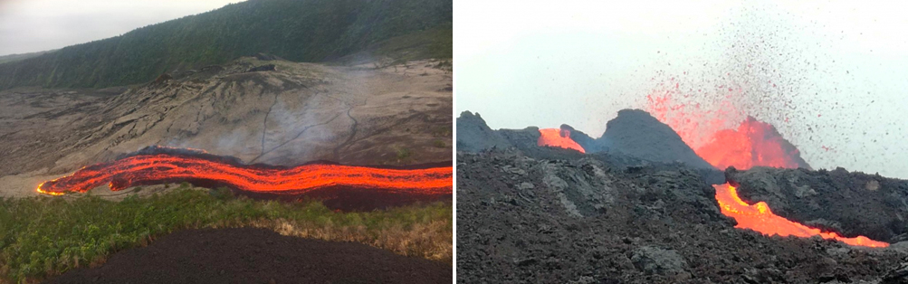 |
Figure 190. On 25 October 2019 the front of the active flow at Piton de la Fournaise had reached the level of the Piton Tremblet by 1700 local time (left). Image by PGHM (Bulletin d'activité du 25 octobre 2019 à 18h00, Heure locale). The following day, the active vent had lava fountains 10-20 m high (right) (Bulletin d'activité du samedi 26 octobre 2019 à 11h00, Heure locale). Courtesy of OVPF/IPGP. |
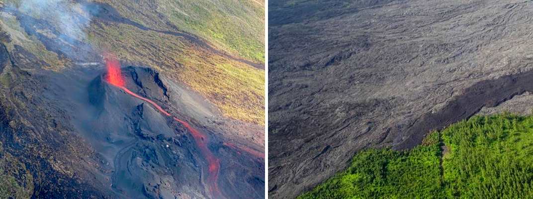 |
Figure 191. The eruptive site of the 25-27 October 2019 eruption at Piton de la Fournaise had one flow still active on 27 October with 10-20 m high lava fountains (left). The flow front stopped that day a few hundred meters before the National Road (right). Courtesy of OVPF/IPGP (Bulletin d'activité du dimanche 27 octobre 2019 à 12h00, Heure locale). |
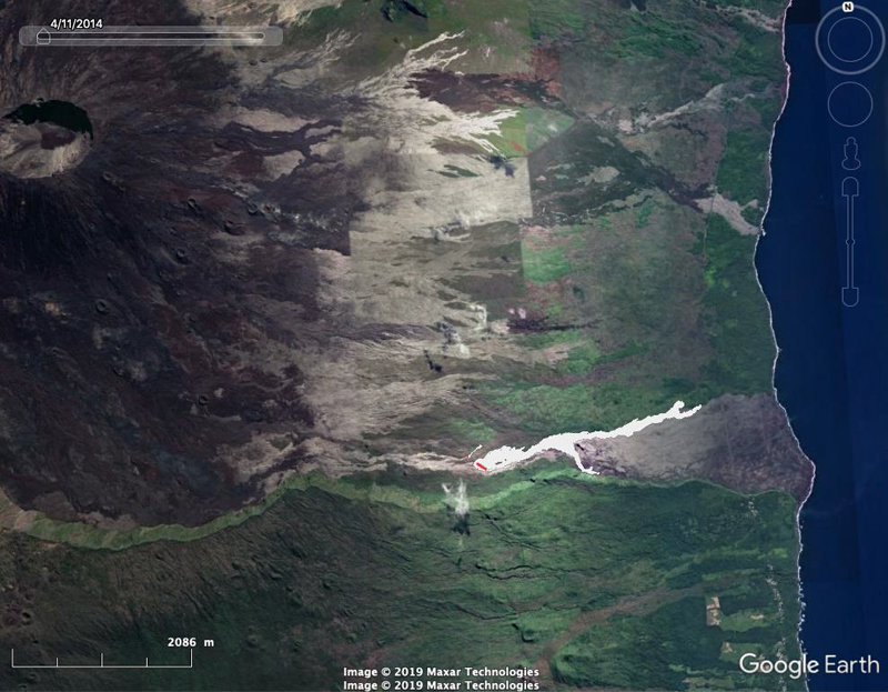 |
Figure 192. The location of the 25-27 October 2019 lava flow at Piton de la Fournaise started at the very base of the SSE flank of Dolomieu cone and traveled 3.6 km E towards the Highway and the coast. Basemap from Google Earth, fissures (red) and flows (in white) derived from aerial photos. Courtesy of OVPF-IPGP (Monthly bulletin of the Piton de la Fournaise Volcanological Observatory, October 2019). |
Geological Summary. Piton de la Fournaise is a massive basaltic shield volcano on the French island of Réunion in the western Indian Ocean. Much of its more than 530,000-year history overlapped with eruptions of the deeply dissected Piton des Neiges shield volcano to the NW. Three scarps formed at about 250,000, 65,000, and less than 5,000 years ago by progressive eastward slumping, leaving caldera-sized embayments open to the E and SE. Numerous pyroclastic cones are present on the floor of the scarps and their outer flanks. Most recorded eruptions have originated from the summit and flanks of Dolomieu, a 400-m-high lava shield that has grown within the youngest scarp, which is about 9 km wide and about 13 km from the western wall to the ocean on the E side. More than 150 eruptions, most of which have produced fluid basaltic lava flows, have occurred since the 17th century. Only six eruptions, in 1708, 1774, 1776, 1800, 1977, and 1986, have originated from fissures outside the scarps.
Information Contacts: Observatoire Volcanologique du Piton de la Fournaise, Institut de Physique du Globe de Paris (OVPF-IPGP), 14 route nationale 3, 27 ème km, 97418 La Plaine des Cafres, La Réunion, France (URL: http://www.ipgp.fr/fr); MIROVA (Middle InfraRed Observation of Volcanic Activity), a collaborative project between the Universities of Turin and Florence (Italy) supported by the Centre for Volcanic Risk of the Italian Civil Protection Department (URL: http://www.mirovaweb.it/); Global Sulfur Dioxide Monitoring Page, Atmospheric Chemistry and Dynamics Laboratory, NASA Goddard Space Flight Center (NASA/GSFC), 8800 Greenbelt Road, Goddard, Maryland, USA (URL: https://so2.gsfc.nasa.gov/).