Copahue
Chile-Argentina
37.856°S, 71.183°W; summit elev. 2953 m
All times are local (unless otherwise noted)
Most of the large edifice of Copahue lies high in the central Chilean Andes, but the active, acidic-lake filled El Agrio crater lies on the Argentinian side of the border at the W edge of the Pliocene Caviahue caldera. Infrequent mild-to-moderate explosive eruptions have been recorded since the 18th century. The most recent eruptive episode with ash plumes lasted from early June 2017 to early December 2018. After 8 months of quiet, renewed phreatic explosions and ash emissions began in August 2019 and were ongoing through October 2019. This report summarizes activity from January through October 2019 and is based on reports issued by Servicio Nacional de Geología y Minería (SERNAGEOMIN) Observatorio Volcanológico de Los Andes del Sur (OVDAS), Buenos Aires Volcanic Ash Advisory Center (VAAC), satellite data, and photographs from nearby residents.
Intermittent steam plumes were reported from the El Agrio crater at the summit during January-July 2019, but no ash emissions were seen. An increase in seismicity and changes in the crater lake level during March led SERNAGEOMIN to increase the Alert Level from Green to Yellow at the beginning of April. Fluctuating tremor signals in the first week of August coincided with satellite imagery that showed the appearance of dark material, possibly ash, on the snow around the summit crater. The first thermal anomaly appeared on 3 September and the first clear ash explosions were recorded on 11 September. Eruptive activity was intermittent through the end of the month; a series of larger explosions beginning on 30 September caused SERNAGEOMIN to raise the Alert Level from Yellow to Orange. A period of more intense explosive activity lasted through the first week of October. The larger explosions then ceased, but during the rest of October there were continuing observations of seismicity, ash emissions, and incandescent ejecta, along with multiple thermal anomalies in the summit area.
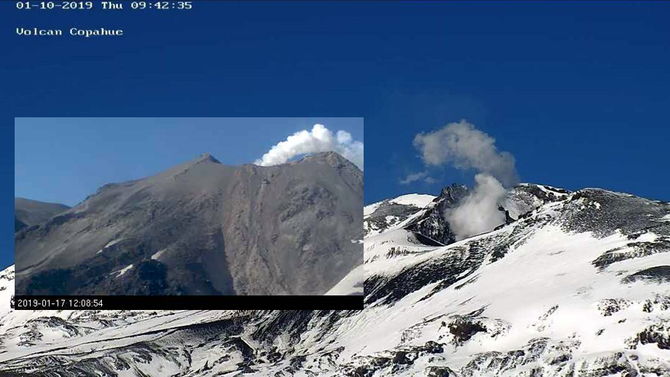
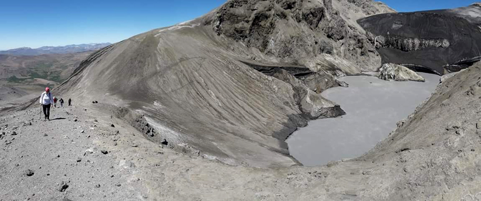
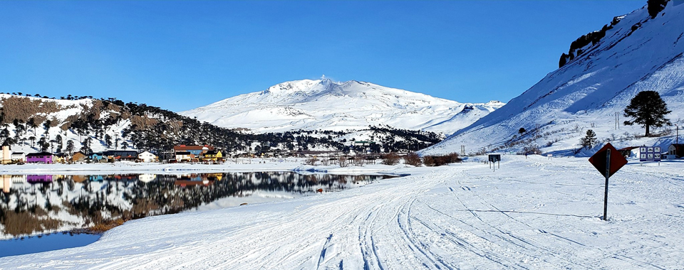
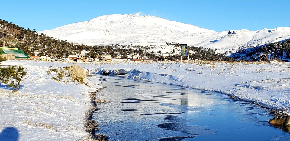
Observations during January-April 2019. Copahue remained at Alert Level Yellow with a 1-km exclusion radius during January 2019 after ash emission in December 2018. Ongoing degassing was reported with white plumes from El Agrio crater rising to 355 m (figure 25). The Alert Level was lowered to Green at the end of the month, and the exclusion radius was reduced to 500 m, although intermittent low-level seismicity in the region continued. SERNAGEOMIN reported a M 3.2 earthquake about 10 km NE of the summit, 2 km deep, on 29 January 2019. The acidic lake inside El Agrio crater was quiet at the end of the month (figure 26).
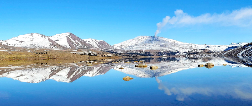
Steam plumes occasionally rose to 180 m above the crater during February 2019. A swarm of 117 volcano-tectonic (VT) seismic events on 22-23 February 2019 was located about 14 km NE of the volcano, with the largest events around a M 3.5. Steam plumes rose to about 280 m above the crater during March. SERNAGEOMIN noted an increase in seismicity during the month, and a decrease in the lake level within El Agrio crater. This led them to increase the Alert Level to Yellow (second on a four-level scale) at the beginning of April. Emissions remained minimal during April (figure 27); an 80 m high steam plume was reported on 4 April. The lake level continued to fall, based on satellite imagery, and a M 3.1 earthquake was reported on 29 April located about 10 km NE of the summit about 10 km deep.
Observations during May-July 2019. Sporadic episodes of low-altitude steam plume degassing were noted during May 2019, but otherwise very little surface activity was reported (figure 28). On 13 May, a steam plume reached 160 m above the crater rim, and on 28 May, the tallest plume rose 200 m above the crater. Hybrid-type earthquakes were recorded early in the month, followed by a slow increase in the amplitude of the tremor signal. Seismicity increased slightly during the second half of the month with activity concentrated closer to the summit crater. A weak SO2 plume was recorded by satellite instruments on 23 May. The level of the lake began increasing during the second half of the month.
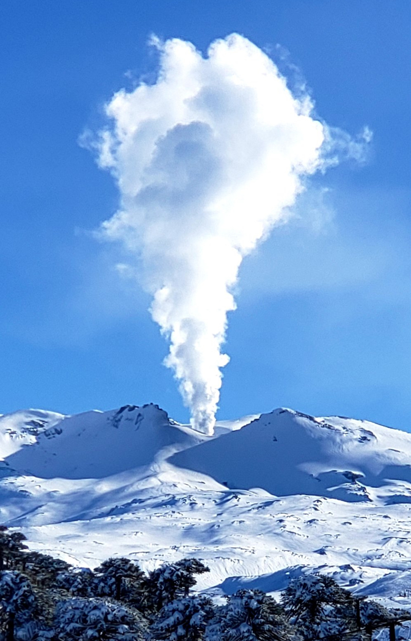
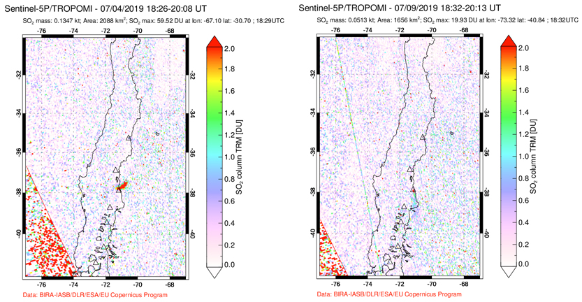
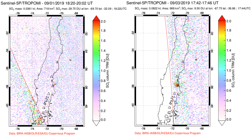
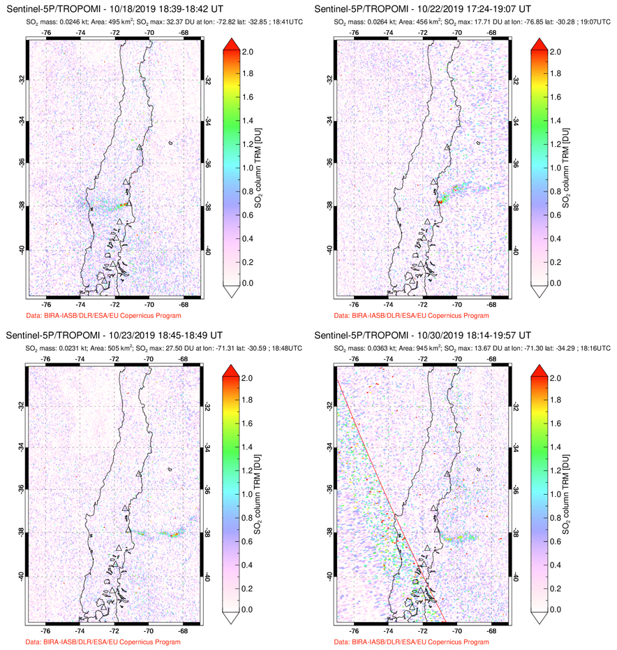
SERNAGEOMIN reported tremor signals with fluctuating amplitude throughout June 2019. Repeated episodes of low-altitude white degassing occurred around the El Agrio crater. On 7 June, a 300 m plume was observed above the crater; the level of the crater lake was variable. On 17 June a 400-m-tall white plume was observed above the crater. Seismicity, although low, increased during the second half of the month. Multiple episodes of low-altitude white degassing occurred around the active crater all during July 2019 (figure 29). On 9 July a plume rose about 450 m above the crater. On 16 July a white plume rose 250 m above the crater. SENAGEOMIN noted a rise in the rate of seismicity during the first half of the month; the tremor signal continued with fluctuating amplitude. Satellite instruments detected small SO2 plumes on 4 and 9 July (figure 30).
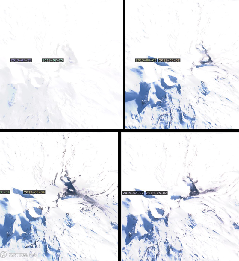
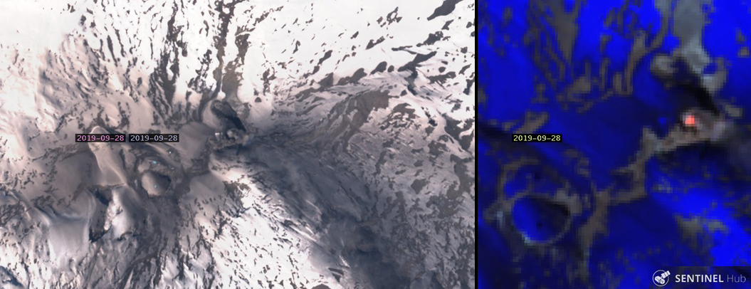
Activity during August-October 2019. Sentinel-2 satellite imagery from 2, 4, 7, and 9 August suggested the ejection of particulate material (figure 31), with dark streaks in the snow extending a few hundred meters E and SE from the crater. Images from the community of Caviahue on 3 and 4 August show distinct discoloration of the snow around the E side of the summit crater (figures 32 and 33). Small but discernible SO2 plumes were detected by satellite instruments on 2, 3, 16, 19, 30, and 31 August. Fluctuating tremor signals continued during August with several episodes of low-altitude white degassing from the El Agrio crater; a white plume on 5 August rose 380 m above the crater. The lake level continued to drop and the Alert Level remained at Yellow.
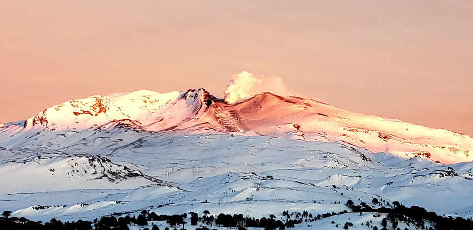
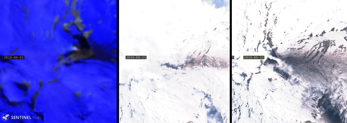
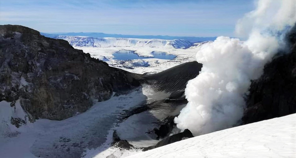
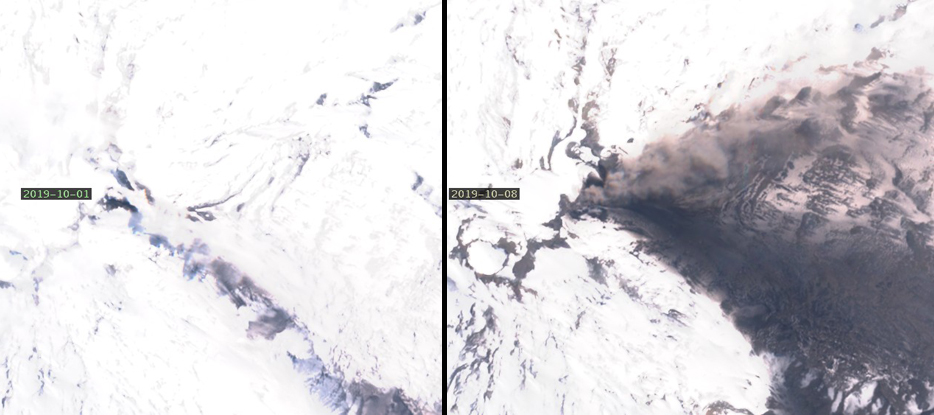
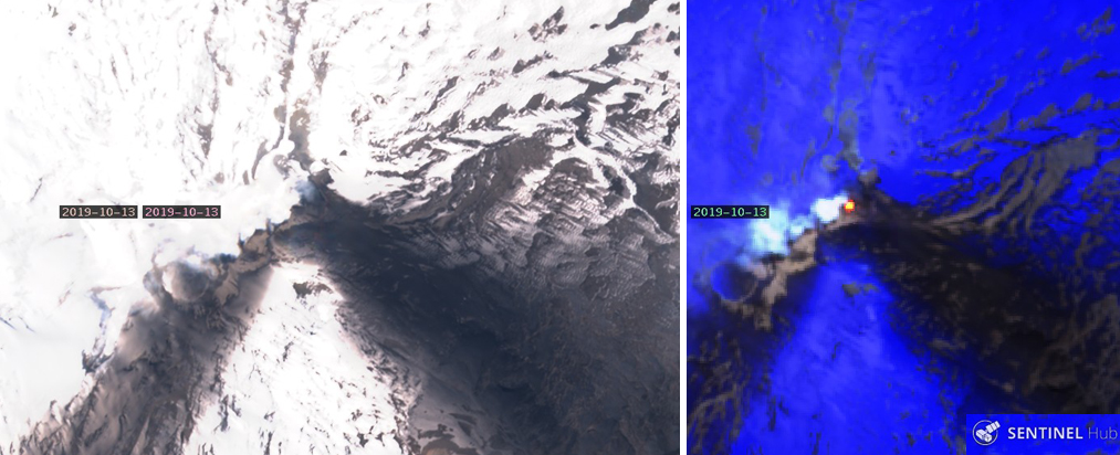
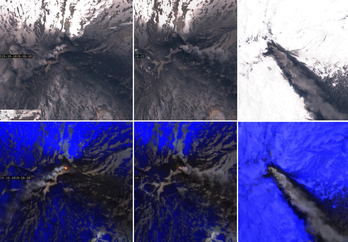
Distinct SO2 plumes were again captured by satellite instruments on 1, 3, and 5-7 September 2019 (figure 34). The first thermal signature in nine months also appeared in Sentinel-2 satellite imagery on 3 September (figure 35). Midday on 9 September, seismometers recorded an increase in the amplitude of a continuous tremor. High clouds prevented clear views of the crater and no ash emissions were observed. Beginning on 11 September, low-energy long-period (LP) events were associated with infrasound signals and low-energy explosions that produced small ash plumes. The largest explosion produced a plume 250 m above the crater. Incandescence and high-temperature ejecta were observed around the emission point. The ash drifted ESE about 3 km. Ten explosions were reported between 11 and 12 September, associated with low-intensity acoustic signals and ash emissions. Plumes reached 430 m above the crater rim on 12 September. Ash deposits on the snow were visible in in Sentinel-2 images on 11 and 13 September, extending about 6 km E from El Agrio crater (figure 35). Images from the ground on 12 September indicated fresh ash on the E flank (figure 36).
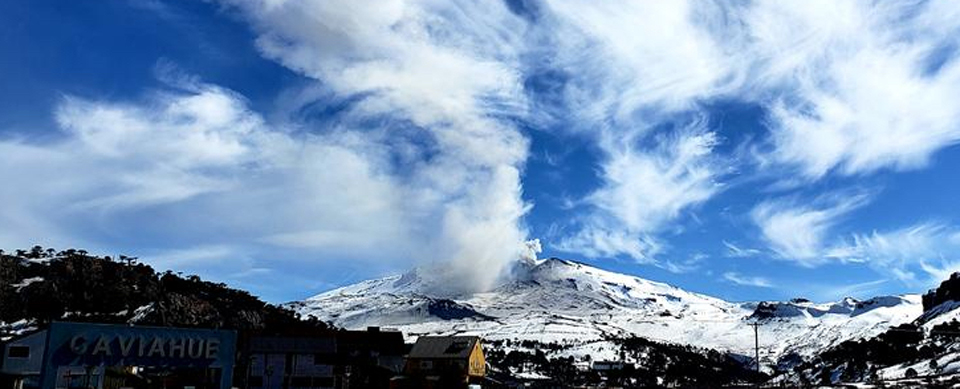
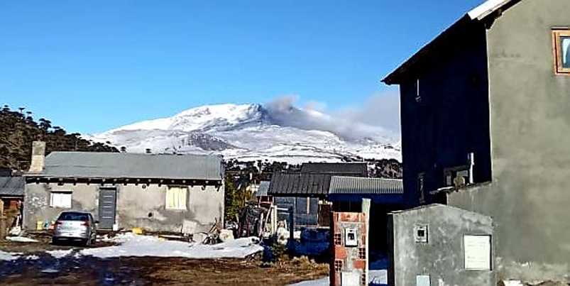
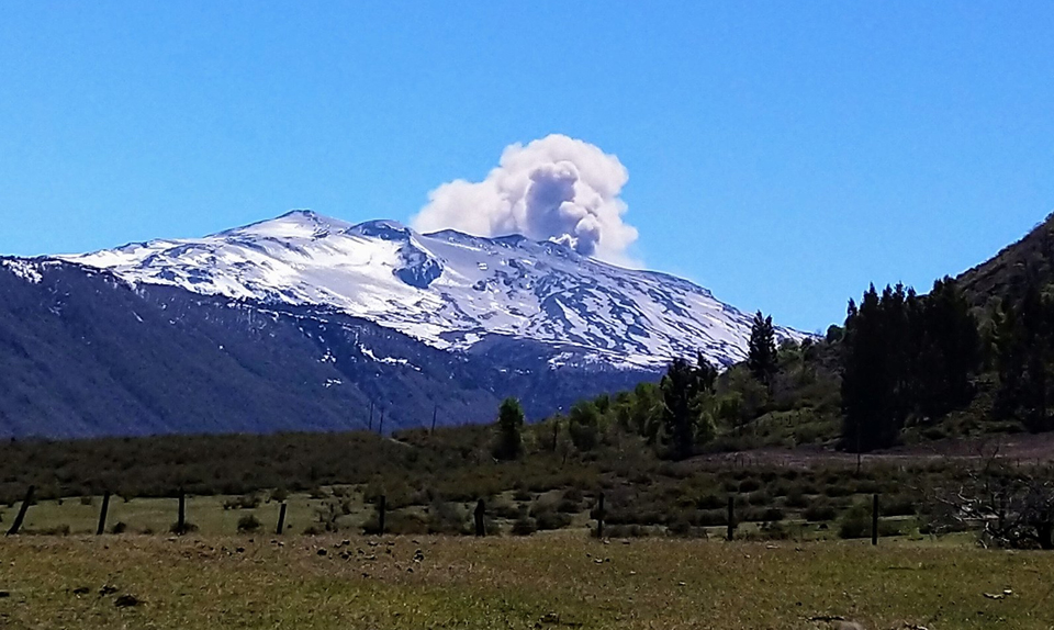
Although fresh snow had covered any ash deposits by 16 September 2019 (figure 37), small thermal anomalies appeared in Sentinel-2 imagery on 16 and 21 September. SO2 plumes were measured by satellite instruments on 21 and 25 September. Photos from Caviahue on 25 September showed ash on the E flank and a steam-and-ash plume drifting NE (figure 38). Ashfall on the snow was visible in satellite imagery on 26 September, and covered a larger area on 28 September; there was also a substantial thermal anomaly that day (figure 39).
During the late afternoon of 30 September, three high-energy LP earthquakes were reported located 5.8 km NE of the El Agrio crater. They were accompanied by abundant lower energy earthquakes in the same area. The VT earthquakes were equivalent to a M 3.5. Inhabitants of Caviahue (12 km E) reported feeling several of the events; atmospheric conditions prevented observation of the summit. This sudden increase in seismicity prompted SERNGEOMIN to raise the Alert Level to Orange and increase the radius of the area of potential impact to 5 km. Seismicity (VT, LP and tremor earthquakes) continued at a high rate into 1 October. Argentina's geologic hazards and mining agency, Servicio Geologico Minero Argentino (SEGEMAR) also issued a notice of the increased warning level on 30 September (figure 40).
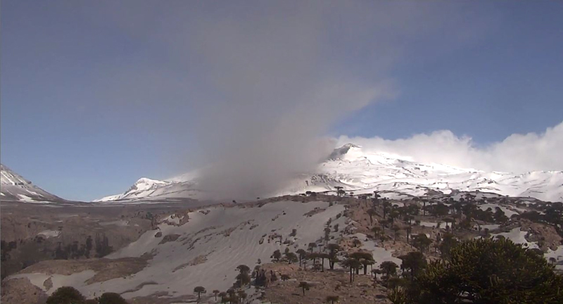
Cameras near the volcano detected ash plumes associated with explosions around the crater at 0945 on 1 October 2019 which continued throughout the first week of the month. Satellite imagery showed streaks of dark ash over snow trending SE and E and from the summit on 1 and 8 October (figure 41). Five separate explosions were recorded during 1-2 October. Persistent degassing was accompanied by episodes of ash emissions and incandescence at night. Seismicity continued during 2-3 October, but poor weather mostly obscured visual evidence of activity; a few pulses of white and gray emissions were observed. Seismic events were located 5-7 km NE at a depths of 0.7-1.7 km, and continued for several days. Clearer skies on 4 October revealed steam plumes and pulses of ash rising from El Agrio crater. Incandescence was visible at night. A ground-based image showed ash covering the E flank and an ash plume drifting NE down the flank (figure 42). The Buenos Aires VAAC reported weak ash emissions on 4 October moving NE at 3.4 km altitude. The webcam showed continuous ash emission from the summit during 4-5 October.
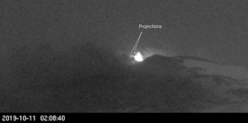
White steam plumes with pulses of ash and incandescence at night were observed on 5 and 6 October. Seismic activity decreased on 6 October. The following day, SERNAGEOMIN lowered the Alert Level to Yellow and reduced the restricted zone to 1,000 m around the summit crater. While seismicity had decreased, ash emissions continued from low-level pulsating explosions which produced ash plumes that drifted E (figure 43). They observed that the total area to that date affected by ashfall was about 24.5 km2, extending up to 5 km W and 6 km E from the summit. They also noted that a pyroclastic cone about 130 m across had appeared inside the crater. Ash emissions and explosions with incandescent ejecta continued during the second week of October (figure 44). A change in wind direction created a several-kilometer-long streak of ash trending SW from the summit by 13 October; a strong thermal anomaly that day indicated continued activity (figure 45). SO2 plumes were recorded by satellite instruments on 1, 3, 4, and 13 October.
Seismicity continued for the rest of October, but no explosions were recorded. Sulfur dioxide emissions were recorded by satellite instruments on 18, 22, 23, and 30 October (figure 46). When weather permitted, constant degassing with episodes of ash emissions from the crater were visible during the day and incandescence appeared at night. Satellite imagery on 18, 23, and 28 October showed substantial ash plumes drifting in different directions from the summit. A large area around the summit crater was covered with dark ash on 18 and 23 October. Fresh snowfall had covered most of the area by 28 October, and the narrow dark streak trending SE underneath the ongoing ash plume was the only surface covered with material (figure 47). Distinct thermal anomalies appeared in satellite images on 16, 18, 23, and 31 October. A number of thermal alerts were recorded by the MIROVA system as well during the second half of the month.
The highest plume noted by SERNAGEOMIN during the second half of the month rose 1,200 m above the crater on 22 October 2019 (figure 48). The Buenos Aires VAAC reported ash emissions from the summit visible in webcams almost every day in October. On 16 October, an ash plume was seen in satellite imagery moving SE at 3.4 km altitude under mostly clear skies; the webcam showed continuous ash emission. A faint plume was barely seen moving S in satellite imagery at 3.4 km altitude on 18 October; the webcam revealed continuous emission of gases and possible dilute volcanic ash. The VAAC reported ash emissions daily from 18-25 October. Drift directions varied from SE, moving to NE on 21-23 October, and back to E and SE the following days. The altitudes ranged from 3.0 to 4.3 km. On 20 October, the plume extended about 80 km SE. The ash appeared as pulses moving NE on 22 and 23 October at 4.3 km altitude. Emissions reappeared in satellite imagery on 28 and 30-31 October, drifting SE and NE at 3.4-3.7 km altitude; incandescence was visible overnight on 30-31 October from the webcam.
Geological Summary. Volcán Copahue is an elongated composite cone constructed along the Chile-Argentina border within the 6.5 x 8.5 km wide Trapa-Trapa caldera that formed between 0.6 and 0.4 million years ago near the NW margin of the 20 x 15 km Pliocene Caviahue (Del Agrio) caldera. The eastern summit crater, part of a 2-km-long, ENE-WSW line of nine craters, contains a briny, acidic 300-m-wide crater lake (also referred to as El Agrio or Del Agrio) and displays intense fumarolic activity. Acidic hot springs occur below the eastern outlet of the crater lake, contributing to the acidity of the Río Agrio, and another geothermal zone is located within Caviahue caldera about 7 km NE of the summit. Infrequent mild-to-moderate explosive eruptions have been recorded since the 18th century. Twentieth-century eruptions from the crater lake have ejected pyroclastic rocks and chilled liquid sulfur fragments.
Information Contacts: Servicio Nacional de Geología y Minería (SERNAGEOMIN), Observatorio Volcanológico de Los Andes del Sur (OVDAS), Avda Sta María No. 0104, Santiago, Chile (URL: http://www.sernageomin.cl/); OPTIC Neuquén, Oficina Provincial de Tecnologías de la Información y la Comunicación- Gobierno de la Provincia del Neuquén, Neuquén, Argentina (URL: https://www.neuqueninforma.gob.ar/tag/optic/, Twitter: @OPTIC_Nqn, https://twitter.com/OPTIC_Nqn); Global Sulfur Dioxide Monitoring Page, Atmospheric Chemistry and Dynamics Laboratory, NASA Goddard Space Flight Center (NASA/GSFC), 8800 Greenbelt Road, Goddard, Maryland, USA (URL: https://so2.gsfc.nasa.gov/); Sentinel Hub Playground (URL: https://www.sentinel-hub.com/explore/sentinel-playground); Valentina Sepulveda, Hotel Caviahue, Caviahue, Argentina (URL: https://twitter.com/valecaviahue, Twitter:@valecaviahue); Cultur Volcan, Journal d'un volcanophile, (URL: https://laculturevolcan.blogspot.com, Twitter: @CulturVolcan); EveLyn, Twitter: @EveCaCid (URL: https://twitter.com/EveCaCid/status/1186663015271321601).