Report on Nyamulagira (DR Congo) — December 2019

Bulletin of the Global Volcanism Network, vol. 44, no. 12 (December 2019)
Managing Editor: Edward Venzke.
Edited by Kadie L. Bennis.
Nyamulagira (DR Congo) Strong thermal anomalies and fumaroles within the summit crater during June-November 2019
Please cite this report as:
Global Volcanism Program, 2019. Report on Nyamulagira (DR Congo) (Bennis, K.L., and Venzke, E., eds.). Bulletin of the Global Volcanism Network, 44:12. Smithsonian Institution. https://doi.org/10.5479/si.GVP.BGVN201912-223020
Nyamulagira
DR Congo
1.408°S, 29.2°E; summit elev. 3058 m
All times are local (unless otherwise noted)
Nyamuragira (also known as Nyamulagira) is a high-potassium basaltic shield volcano located in the Virunga Volcanic Province (VVP) in the Democratic Republic of the Congo. Previous volcanism consisted of the reappearance of a lava lake in the summit crater in mid-April 2018, lava emissions, and high seismicity (BGVN 44:05). Current activity includes strong thermal signatures, continued inner crater wall collapses, and continued moderate seismicity. The primary source of information for this June-November 2019 report comes from the Observatoire Volcanologique de Goma (OVG) and satellite data and imagery from multiple sources.
OVG reported in the July 2019 monthly that the inner crater wall collapses that were observed in May continued to occur. During this month, there was a sharp decrease in the lava lake level, and it is no longer visible. However, the report stated that lava fountaining was visible from a small cone within this crater, though its activity has also decreased since 2014. In late July, a thermal anomaly and fumaroles were observed originating from this cone (figure 78). Seismicity remained moderate throughout this reporting period.
 |
Figure 78. Photograph showing the small active cone within the crater of Nyamuragira in late July 2019. Fumaroles are also observed within the crater originating from the small cone. Courtesy of Sergio Maguna. |
MIROVA (Middle InfraRed Observation of Volcanic Activity) analysis of MODIS satellite data shows strong, frequent thermal anomalies within 5 km of the summit between June through November (figure 79). The strength of these thermal anomalies noticeably decreases briefly in September. MODVOLC thermal alerts registered 54 thermal hotspots dominantly near the N area of the crater during June through November 2019. Satellite imagery from Sentinel-2 corroborated this data, showing strong thermal anomalies within the summit crater during this same timeframe (figure 80).
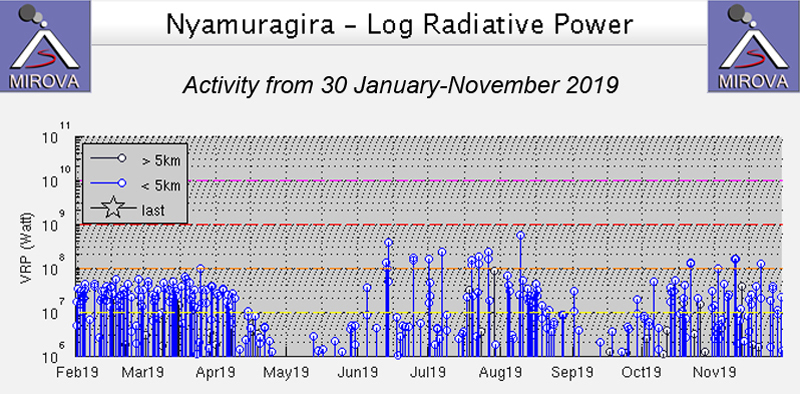 |
Figure 79. The MIROVA graph of thermal activity (log radiative power) at Nyamuragira during 30 January through November 2019 shows strong, frequent thermal anomalies through November with a brief decrease in activity in late April-early May and early September. Courtesy of MIROVA. |
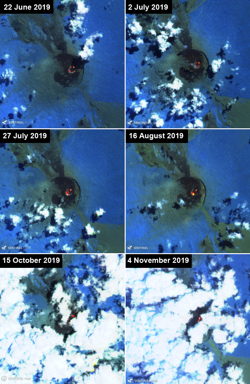 |
Figure 80. Sentinel-2 thermal satellite imagery (bands 12, 11, 8A) confirmed ongoing thermal activity at Nyamuragira into November 2019. Courtesy of Sentinel Hub Playground. |
Geological Summary. Africa's most active volcano, Nyamulagira (also known as Nyamuragira), is a massive high-potassium basaltic shield about 25 km N of Lake Kivu and 13 km NNW of the steep-sided Nyiragongo volcano. The summit is truncated by a small 2 x 2.3 km caldera that has walls up to about 100 m high. Documented eruptions have occurred within the summit caldera, as well as from the numerous flank fissures and cinder cones. A lava lake in the summit crater, active since at least 1921, drained in 1938, at the time of a major flank eruption. Recent lava flows extend down the flanks more than 30 km from the summit as far as Lake Kivu; extensive lava flows from this volcano have covered 1,500 km2 of the western branch of the East African Rift.
Information Contacts: Observatoire Volcanologique de Goma (OVG), Departement de Geophysique, Centre de Recherche en Sciences Naturelles, Lwiro, D.S. Bukavu, DR Congo; Sentinel Hub Playground (URL: https://www.sentinel-hub.com/explore/sentinel-playground); MIROVA (Middle InfraRed Observation of Volcanic Activity), a collaborative project between the Universities of Turin and Florence (Italy) supported by the Centre for Volcanic Risk of the Italian Civil Protection Department (URL: http://www.mirovaweb.it/); Sergio Maguna (Facebook: https://www.facebook.com/sergio.maguna.9, images posted at https://www.facebook.com/sergio.maguna.9/posts/1267625096730837).