Report on Aira (Japan) — January 2020

Bulletin of the Global Volcanism Network, vol. 45, no. 1 (January 2020)
Managing Editor: Edward Venzke.
Edited by Kadie L. Bennis.
Aira (Japan) Ongoing explosions with ejecta and ash plumes, along with summit incandescence, during July-December 2019
Please cite this report as:
Global Volcanism Program, 2020. Report on Aira (Japan) (Bennis, K.L., and Venzke, E., eds.). Bulletin of the Global Volcanism Network, 45:1. Smithsonian Institution. https://doi.org/10.5479/si.GVP.BGVN202001-282080
Aira
Japan
31.5772°N, 130.6589°E; summit elev. 1117 m
All times are local (unless otherwise noted)
Sakurajima is a highly active stratovolcano situated in the Aira caldera in southern Kyushu, Japan. Common volcanism for this recent eruptive episode since March 2017 includes frequent explosions, ash plumes, and scattered ejecta. Much of this activity has been focused in the Minamidake crater since 1955; the Showa crater on the E flank has had intermittent activity since 2006. This report updates activity during July through December 2019 with the primary source information from monthly reports by the Japan Meteorological Agency (JMA) and various satellite data.
During July to December 2019, explosive eruptions and ash plumes were reported multiple times per week by JMA. November was the most active, with 137 eruptive events, seven of which were explosive while August was the least active with no eruptive events recorded (table 22). Ash plumes rose between 800 m to 5.5 km above the crater rim during this reporting period. Large blocks of incandescent ejecta traveled as far as 1.7 km from the Minamidake crater during explosions in September through December. The Kagoshima Regional Meteorological Observatory (11 km WSW) reported monthly amounts of ashfall during each month, with a high of 143 g/m2 during October. Occasionally at night throughout this reporting period, crater incandescence was observed with a highly sensitive surveillance camera. All explosive activity originated from the Minamidake crater; the adjacent Showa crater produced mild thermal anomalies and gas-and-steam plumes.
Table 22. Monthly summary of eruptive events recorded at Sakurajima's Minamidake crater in the Aira caldera, July through December 2019. The number of events that were explosive in nature are in parentheses. No events were recorded at the Showa crater during this time. Ashfall is measured at the Kagoshima Local Meteorological Observatory (KLMO), 10 km W of Showa crater. Data courtesy of JMA (July to December 2019 monthly reports).
| Month | Ash emissions (explosive) | Max plume height above crater | Max ejecta distance from crater | Total amount of ashfall (g/m2) |
| Jul 2019 | 9 (5) | 3.8 km | 1.1 km | -- |
| Aug 2019 | -- | 800 m | -- | 2 |
| Sep 2019 | 32 (11) | 3.4 km | 1.7 km | 115 |
| Oct 2019 | 62 (41) | 3.0 km | 1.7 km | 143 |
| Nov 2019 | 137 (77) | 5.5 km | 1.7 km | 69 |
| Dec 2019 | 71 (49) | 3.3 km | 1.7 km | 54 |
An explosion that occurred at 1044 on 4 July 2019 produced an ash plume that rose up to 3.2 km above the Minamidake crater rim and ejected material 1.1 km from the vent. Field surveys conducted on 17 and 23 July measured SO2 emissions that were 1,200-1,800 tons/day. Additional explosions between 19-22 July generated smaller plumes that rose to 1.5 km above the crater and ejected material 1.1 km away. On 28 July explosions at 1725 and 1754 produced ash plumes 3.5-3.8 km above the crater rim, which resulted in ashfall in areas N and E of Sakurajima (figure 86), including Kirishima City (20 km NE), Kagoshima Prefecture (30 km SE), Yusui Town (40 km N), and parts of the Kumamoto Prefecture (140 km NE).
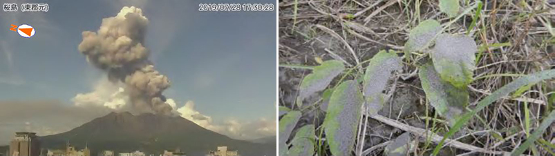 |
Figure 86. Photo of the Sakurajima explosion at 1725 on 28 July 2019 resulting in an ash plume rising 3.8 km above the crater (left). An on-site field survey on 29 July observed ashfall on roads and vegetation on the N side of the island (right). Photo by Moto Higashi-gun (left), courtesy of JMA (July 2019 report). |
The month of August 2019 showed the least activity and consisted of mainly small eruptive events occurring up to 800 m above the crater; summit incandescence was observed with a highly sensitive surveillance camera. SO2 emissions were measured on 8 and 13 August with 1,000-2,000 tons/day, which was slightly greater than the previous month. An extensometer at the Arimura Observation Tunnel and an inclinometer at the Amida River recorded slight inflation on 29 August, but continuous GNSS (Global Navigation Satellite System) observations showed no significant changes.
In September 2019 there were 32 eruptive events recorded, of which 11 were explosions, more than the previous two months. Seismicity also increased during this month. An extensometer and inclinometer recorded inflation at the Minamidake crater on 9 September, which stopped after the eruptive events. On 16 September, an eruption at 0746 produced an ash plume that rose 2.8 km above the crater rim and drifted SW; a series of eruptive events followed from 0830-1110 (figure 87). Explosions on 18 and 20 September produced ash plumes that rose 3.4 km above the crater rim and ejecting material as far as 1.7 km from the summit crater on the 18th and 700 m on the 20th. Field surveys measured an increased amount of SO2 emissions ranging from 1,100 to 2,300 tons/day during September.
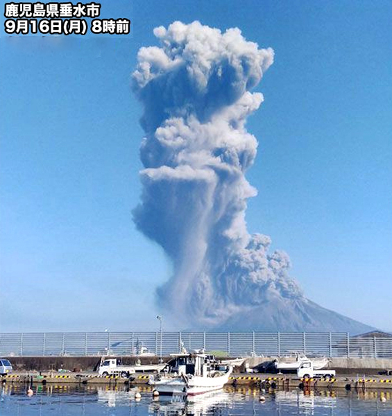 |
Figure 87. Webcam image of an ash plume rising 2.8 km from the Minamidake crater at Sakurajima on 16 September 2019. Courtesy of Weathernews Inc. |
Seismicity, SO2 emissions, and the number of eruptions continued to increase in October 2019, 41 of which were explosive. Field surveys conducted on 1, 11, and 15 October reported that SO2 emissions were 2,000-2,800 tons/day. An explosion at 0050 on 12 October produced an ash plume that traveled 1.7 km from the Minamidake crater. Explosions between 16 and 19 October produced an ash plume that rose up to 3 km above the crater rim (figure 88). The Japan Maritime Self-Defense Force 1st Air group observed gas-and-steam plumes rising from both the Minamidake and Showa craters on 25 October. The inflation reported from 16 September began to slow in late October.
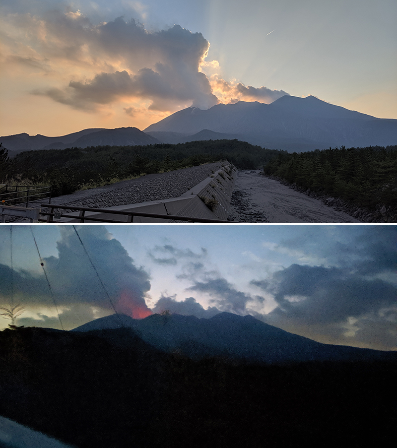 |
Figure 88. Photos taken from the E side of Sakurajima showing gas-and-steam emissions with some amount of ash rising from the volcano on 16 October 2019 after an explosion around 1200 that day (top). At night, summit incandescence is observed (bottom). Courtesy of Bradley Pitcher, Vanderbilt University. |
November 2019 was the most active month during this reporting period with increased seismicity, SO2 emissions, and 137 eruptive events, 77 of which were explosive. GNSS observations indicated that inflation began to slow during this month. On 8 November, an explosion at 1724 produced an ash plume up to a maximum of 5.5 km above the crater rim and drifted E. This explosion ejected large blocks as far as 500-800 m away from the crater (figure 89). The last time plumes rose above 5 km from the vents occurred on 26 July 2016 at the Showa crater and on 7 October 2000 at the Minamidake crater. Field surveys on 8, 21, and 29 November measured increased SO2 emissions ranging from 2,600 to 3,600 tons/day. Eruptions between 13-19 November produced ash plumes that rose up to 3.6 km above the crater and ejected large blocks up 1.7 km away. An onsite survey on 29 November used infrared thermal imaging equipment to observe incandescence and geothermal areas near the Showa crater and the SE flank of Minamidake (figure 90).
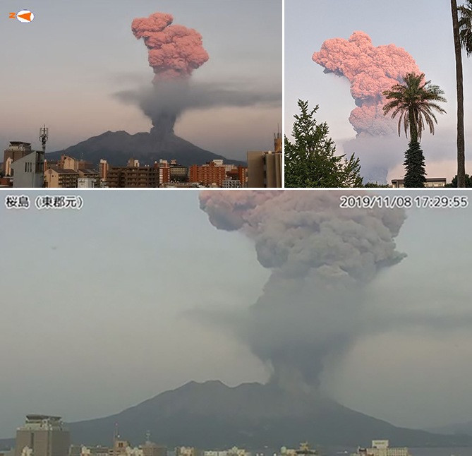 |
Figure 89. Photos of an ash plume rising 5.5 km above Sakurajima on 8 November 2019 and drifting E. Photo by Moto Higashi-gun (top left), courtesy of JMA (November 2019 report) and the Geoscientific Network of Chile. |
 |
Figure 90. Webcam image of nighttime incandescence and gas-and-steam emissions with some amount of ash at Sakurajima on 29 November 2019. Courtesy of JMA (November 2019 report). |
Volcanism, which included seismicity, SO2 emissions, and eruptive events, decreased during December 2019. Explosions during 4-10 December produced ash plumes that rose up to 2.6 km above the crater rim and ejected material up to 1.7 km away. Field surveys conducted on 6, 16, and 23 December measured SO2 emissions around 1,000-3,000 tons/day. On 24 December, an explosion produced an ash plume that rose to 3.3 km above the crater rim, this high for this month.
Sentinel-2 natural color satellite imagery showed dense ash plumes in late August 2019, early November, and through December (figure 91). These plumes drifted in different directions and rose to a maximum 5.5 km above the crater rim on 8 November.
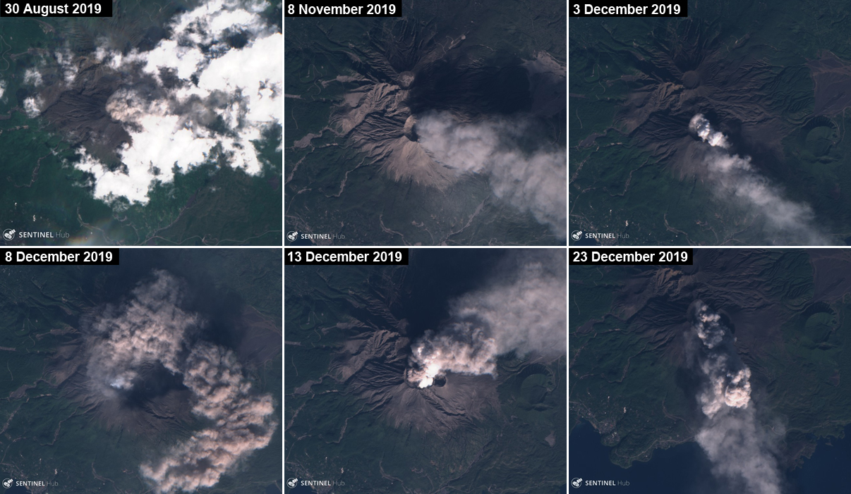 |
Figure 91. Natural color Sentinel-2 satellite images of Sakurajima within the Aira caldera from late August through December 2019 showed dense ash plumes rising from the Minamidake crater. Courtesy of Sentinel Hub Playground. |
MIROVA (Middle InfraRed Observation of Volcanic Activity) analysis of MODIS satellite data showed intermittent thermal anomalies beginning in mid-August to early September 2019 after a nearly two-month hiatus (figure 92). Activity increased by early November and continued through December. Three Sentinel-2 thermal satellite images between late July and early October showed distinct thermal hotspots within the Minamidake crater, in addition to faint gas-and-steam emissions in July and September (figure 93).
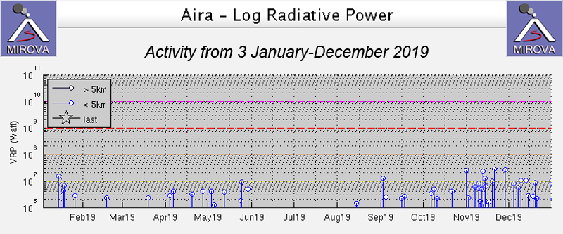 |
Figure 92. Thermal anomalies at Sakurajima during January-December 2019 as recorded by the MIROVA system (Log Radiative Power) started up in mid-August to early September after a two-month break and continued through December. Courtesy of MIROVA. |
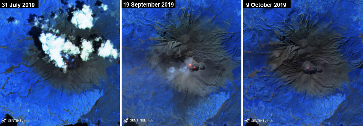 |
Figure 93. Sentinel-2 thermal satellite images showing small thermal anomalies and gas-and-steam emissions (left and middle) at Sakurajima within the Minamidake crater between late July and early October 2019. All images with "Atmospheric penetration" (bands 12, 11, 8A) rendering; courtesy of Sentinel Hub Playground. |
Geological Summary. The Aira caldera in the northern half of Kagoshima Bay contains the post-caldera Sakurajima volcano, one of Japan's most active. Eruption of the voluminous Ito pyroclastic flow accompanied formation of the 17 x 23 km caldera about 22,000 years ago. The smaller Wakamiko caldera was formed during the early Holocene in the NE corner of the caldera, along with several post-caldera cones. The construction of Sakurajima began about 13,000 years ago on the southern rim and built an island that was joined to the Osumi Peninsula during the major explosive and effusive eruption of 1914. Activity at the Kitadake summit cone ended about 4,850 years ago, after which eruptions took place at Minamidake. Frequent eruptions since the 8th century have deposited ash on the city of Kagoshima, located across Kagoshima Bay only 8 km from the summit. The largest recorded eruption took place during 1471-76.
Information Contacts: Japan Meteorological Agency (JMA), 1-3-4 Otemachi, Chiyoda-ku, Tokyo 100-8122, Japan (URL: http://www.jma.go.jp/jma/indexe.html); MIROVA (Middle InfraRed Observation of Volcanic Activity), a collaborative project between the Universities of Turin and Florence (Italy) supported by the Centre for Volcanic Risk of the Italian Civil Protection Department (URL: http://www.mirovaweb.it/); Sentinel Hub Playground (URL: https://www.sentinel-hub.com/explore/sentinel-playground); Weathernews Inc. (Twitter: @wni_jp, https://twitter.com/wni_jp, URL: https://weathernews.jp/s/topics/201608/210085/, photo posted at https://twitter.com/wni_jp/status/1173382407216652289); Bradley Pitcher, Vanderbilt University, Nashville. TN, USA (URL: https://bradpitcher.weebly.com/, Twitter: @TieDyeSciGuy, photo posted at https://twitter.com/TieDyeSciGuy/status/1185191225101471744); Geoscientific Network of Chile (Twitter: @RedGeoChile, https://twitter.com/RedGeoChile, Facebook: https://www.facebook.com/RedGeoChile/, photo posted at https://twitter.com/RedGeoChile/status/1192921768186515456).