Report on Barren Island (India) — February 2020

Bulletin of the Global Volcanism Network, vol. 45, no. 2 (February 2020)
Managing Editor: Edward Venzke.
Edited by Kadie L. Bennis.
Barren Island (India) Thermal anomalies and small ash plumes during February-April 2019 and September 2019-January 2020
Please cite this report as:
Global Volcanism Program, 2020. Report on Barren Island (India) (Bennis, K.L., and Venzke, E., eds.). Bulletin of the Global Volcanism Network, 45:2. Smithsonian Institution. https://doi.org/10.5479/si.GVP.BGVN202002-260010
Barren Island
India
12.278°N, 93.858°E; summit elev. 354 m
All times are local (unless otherwise noted)
Barren Island is a remote stratovolcano located east of India in the Andaman Islands. Its most recent eruptive episode began in September 2018 and has included lava flows, explosions, ash plumes, and lava fountaining (BGVN 44:02). This report updates information from February 2019 through January 2020 using various satellite data as a primary source of information.
MIROVA (Middle InfraRed Observation of Volcanic Activity) analysis of MODIS satellite data showed intermittent thermal anomalies within 5 km of the summit from mid-February 2019 through January 2020 (figure 41). There was a period of relatively low to no discernible activity between May to September 2019. The MODVOLC algorithm for MODIS thermal anomalies in comparison with Sentinel-2 thermal satellite imagery and Suomi NPP/VIIRS sensor data, registered elevated temperatures during late February 2019, early March, sparsely in April, late October, sparsely in November, early December, and intermittently in January 2020 (figure 42). Sentinel-2 thermal satellite imagery shows these thermal hotspots differing in strength from late February to late January 2020 (figure 43). The thermal anomalies in these satellite images are occasionally accompanied by ash plumes (25 February 2019, 23 October 2019, and 21 January 2020) and gas-and-steam emissions (26 April 2019).
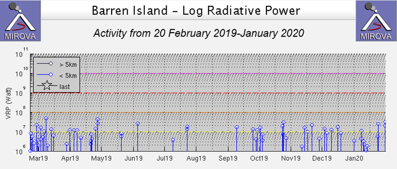 |
Figure 41. Intermittent thermal anomalies at Barren Island for 20 February 2019 through January 2020 occurred dominantly between late March to late April 2019 and late September 2019 through January 2020. Courtesy of MIROVA. |
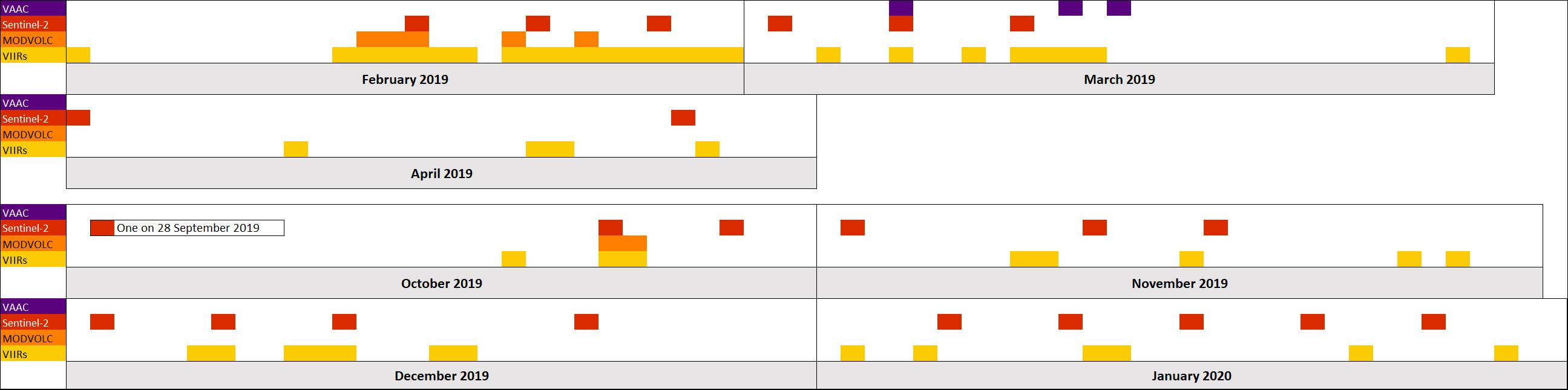 |
Figure 42. Timeline summary of observed activity at Barren Island from February 2019 through January 2020. For Sentinel-2, MODVOLC, and VIIRS data, the dates indicated are when thermal anomalies were detected. White areas indicated no activity was observed, which may also be due to meteoric clouds. Data courtesy of Darwin VAAC, Sentinel Hub Playground, HIGP, and NASA Worldview using the "Fire and Thermal Anomalies" layer. |
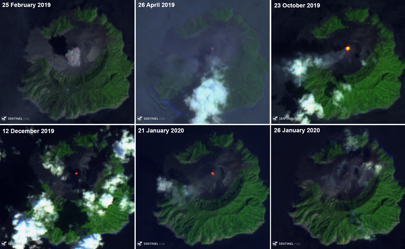 |
Figure 43. Sentinel-2 thermal images show ash plumes, gas-and-steam emissions, and thermal anomalies (bright yellow-orange) at Barren Island during February 2019-January 2020. The strongest thermal signature was observed on 23 October while the weakest one is observed on 26 January. Sentinel-2 False color (bands 12, 11, 4) images courtesy of Sentinel Hub Playground. |
The Darwin Volcanic Ash Advisory Center (VAAC) reported ash plumes rising from the summit on 7, 14, and 16 March 2019. The maximum altitude of the ash plume occurred on 7 March, rising 1.8 km altitude, drifting W and NW and 1.2 km altitude, drifting E and ESE, based on observations from Himawari-8. The VAAC reports for 14 and 16 March reported the ash plumes rising 0.9 km and 1.2 km altitude, respectively drifting W and W.
Geological Summary. Barren Island, a possession of India in the Andaman Sea about 135 km NE of Port Blair in the Andaman Islands, is the only historically active volcano along the N-S volcanic arc extending between Sumatra and Burma (Myanmar). It is the emergent summit of a volcano that rises from a depth of about 2250 m. The small, uninhabited 3-km-wide island contains a roughly 2-km-wide caldera with walls 250-350 m high. The caldera, which is open to the sea on the west, was created during a major explosive eruption in the late Pleistocene that produced pyroclastic-flow and -surge deposits. Historical eruptions have changed the morphology of the pyroclastic cone in the center of the caldera, and lava flows that fill much of the caldera floor have reached the sea along the western coast.
Information Contacts: MIROVA (Middle InfraRed Observation of Volcanic Activity), a collaborative project between the Universities of Turin and Florence (Italy) supported by the Centre for Volcanic Risk of the Italian Civil Protection Department (URL: http://www.mirovaweb.it/); Hawai'i Institute of Geophysics and Planetology (HIGP) - MODVOLC Thermal Alerts System, School of Ocean and Earth Science and Technology (SOEST), Univ. of Hawai'i, 2525 Correa Road, Honolulu, HI 96822, USA (URL: http://modis.higp.hawaii.edu/); Darwin Volcanic Ash Advisory Centre (VAAC), Bureau of Meteorology, Northern Territory Regional Office, PO Box 40050, Casuarina, NT 0811, Australia (URL: http://www.bom.gov.au/info/vaac/); Sentinel Hub Playground (URL: https://www.sentinel-hub.com/explore/sentinel-playground); NASA Worldview (URL: https://worldview.earthdata.nasa.gov/).