Report on Ubinas (Peru) — March 2020

Bulletin of the Global Volcanism Network, vol. 45, no. 3 (March 2020)
Managing Editor: Edward Venzke.
Edited by Janine B. Krippner.
Ubinas (Peru) Explosions produced ash plumes in September 2019; several lahars generated in January and February 2020
Please cite this report as:
Global Volcanism Program, 2020. Report on Ubinas (Peru) (Krippner, J.B., and Venzke, E., eds.). Bulletin of the Global Volcanism Network, 45:3. Smithsonian Institution. https://doi.org/10.5479/si.GVP.BGVN202003-354020
Ubinas
Peru
16.345°S, 70.8972°W; summit elev. 5608 m
All times are local (unless otherwise noted)
Ubinas, located 70 km from the city of Arequipa in Peru, has produced frequent eruptions since 1550 characterized by ash plumes, ballistic ejecta (blocks and bombs), some pyroclastic flows, and lahars. Activity is focused at the summit crater (figure 53). A new eruptive episode began on 24 June 2019, with an ash plume reaching 12 km altitude on 19 July. This report summarizes activity during September 2019 through February 2020 and is based on agency reports and satellite data.
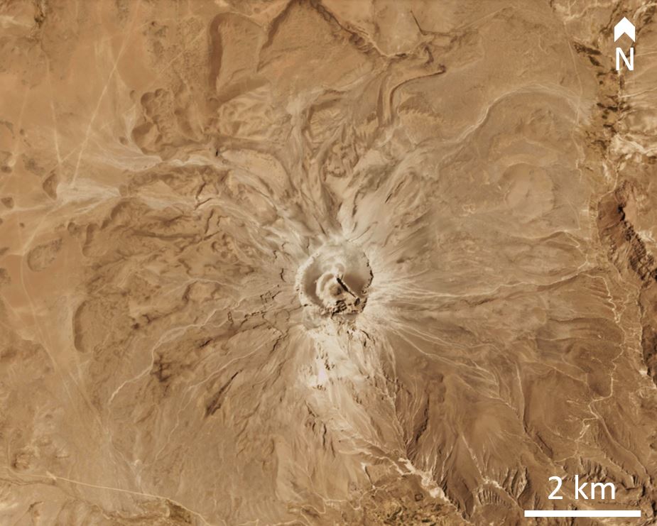 |
Figure 53. A PlanetScope satellite image of Ubinas on 16 December 2019. Courtesy of PlanetLabs. |
Prior to September 2019 the last explosion occurred on 22 July. At 2145 on 1 September moderate, continuous ash emission occurred reaching nearly 1 km above the crater. An explosion produced an ash plume at 1358 on the 3rd that reached up to 1.3 km above the summit; six minutes later ashfall and lapilli up to 1.5 cm in diameter was reported 6 km away, with ashfall reported up to 8 km away (figure 54 and 55). Three explosions produced ash plumes at 0456, 0551, and 0844 on 4 September, with the two later ash plumes reaching around 2 km above the crater. The ash plume dispersed to the south and ashfall was reported in Ubinas, Tonohaya, San Miguel, Anascapa, Huatahua, Huarina, and Matalaque, reaching a thickness of 1 mm in Ubinas.
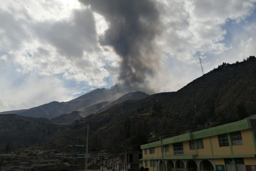 |
Figure 54. An eruption at Ubinas produced an ash plume up to 1.3 km on at 1358 on 3 September 2019. Courtesy of INGEMMET. |
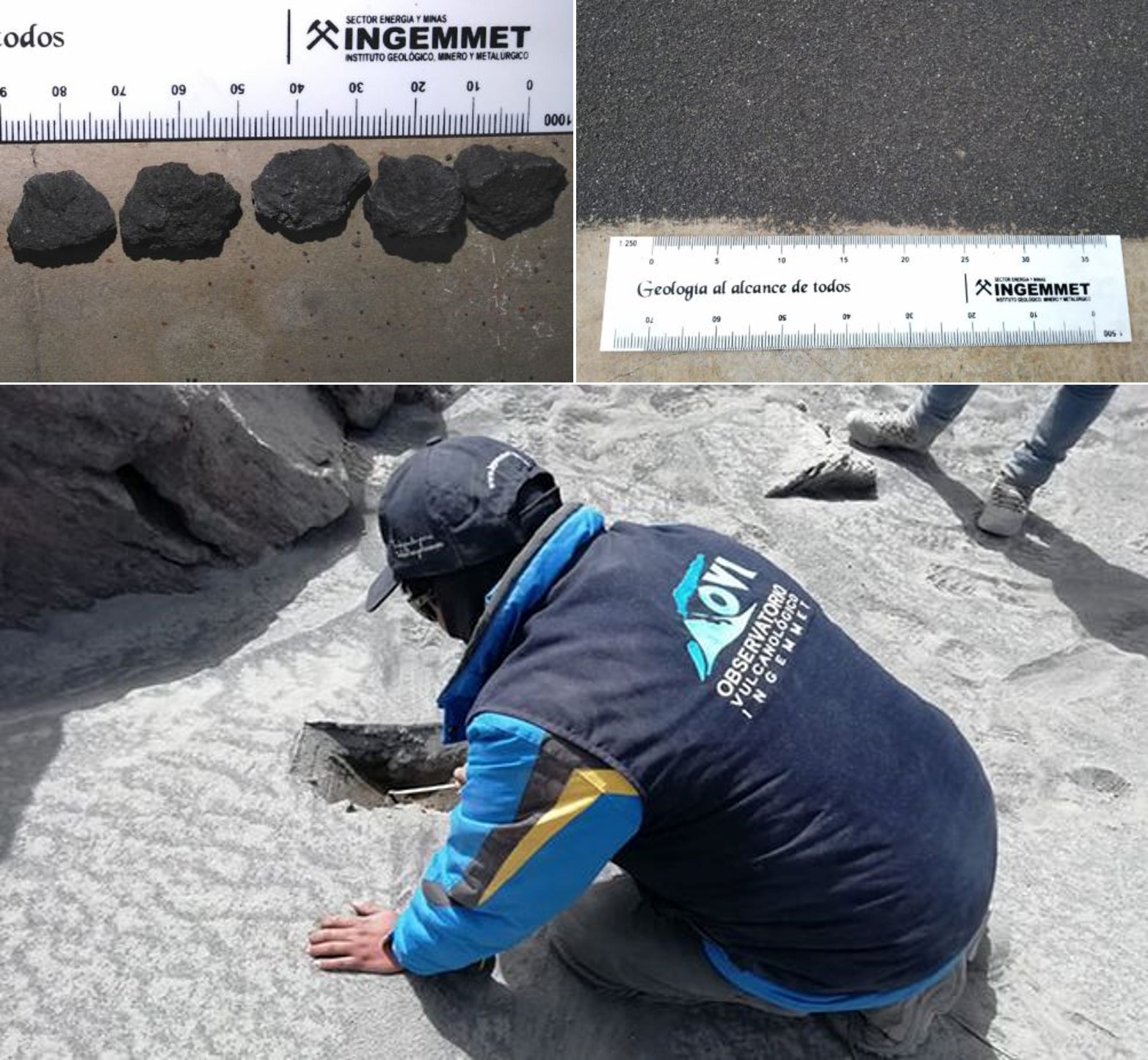 |
Figure 55. Ash and lapilli fall up to 1.5 cm in diameter was reported 6 km away from Ubinas on 3 September 2019 (top) and an Ingemmet geologist collects ash samples from the last three explosions. Courtesy of INGEMMET. |
During 8-9 September there were three explosions generating ash plumes to less than 2.5 km, with the largest occurring at 1358 and producing ashfall in the Moquegua region to the south. Following these events, gas and water vapor were continuously emitted up to 1 km above the crater. There was an increase in seismicity during the 10-11th and an explosion produced a 1.5 km high (above the crater) ash plume at 0726 on the 12th, which dispersed to the S and SE (figure 56). During 10-15 September there was continuous emission of gas (blue in color) and steam up to 1.5 km above the volcano. Gas emission, thermal anomalies, and seismicity continued during 16-29 September, but no further explosions were recorded.
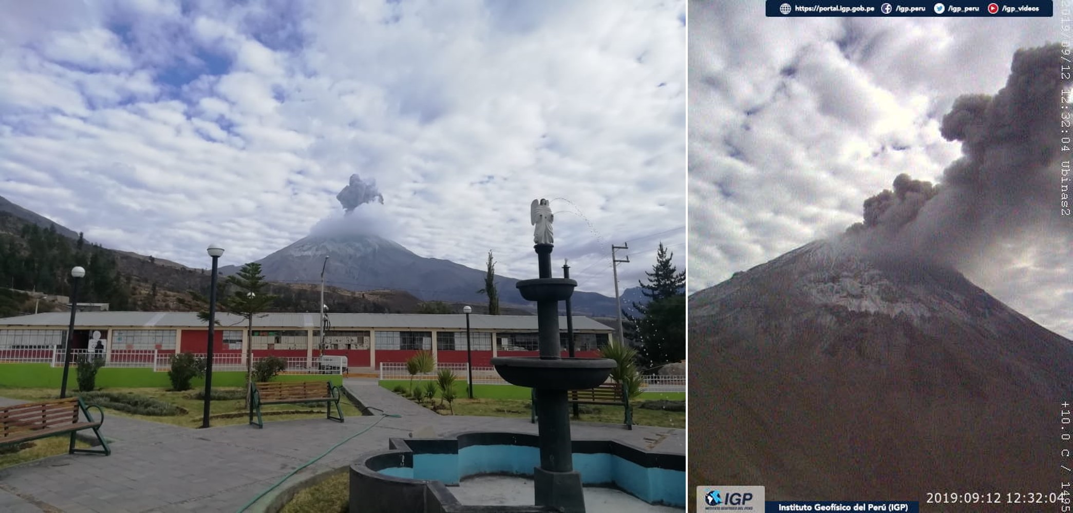 |
Figure 56. An explosion at Ubinas on 12 September 2019 produced an ash plume to 1.5 km above the volcano. The ash dispersed to the S and SE. Courtesy of IGP. |
Throughout October activity consisted of seismicity, elevated temperatures within the crater, and gas emissions reaching 800 to 1,500 m above the crater. No explosions were recorded. Drone footage released in early October (figure 57) shows the gas emissions and provided a view of the crater floor (figure 58). On the 15th IGP reported that the likelihood of an eruption had reduced.
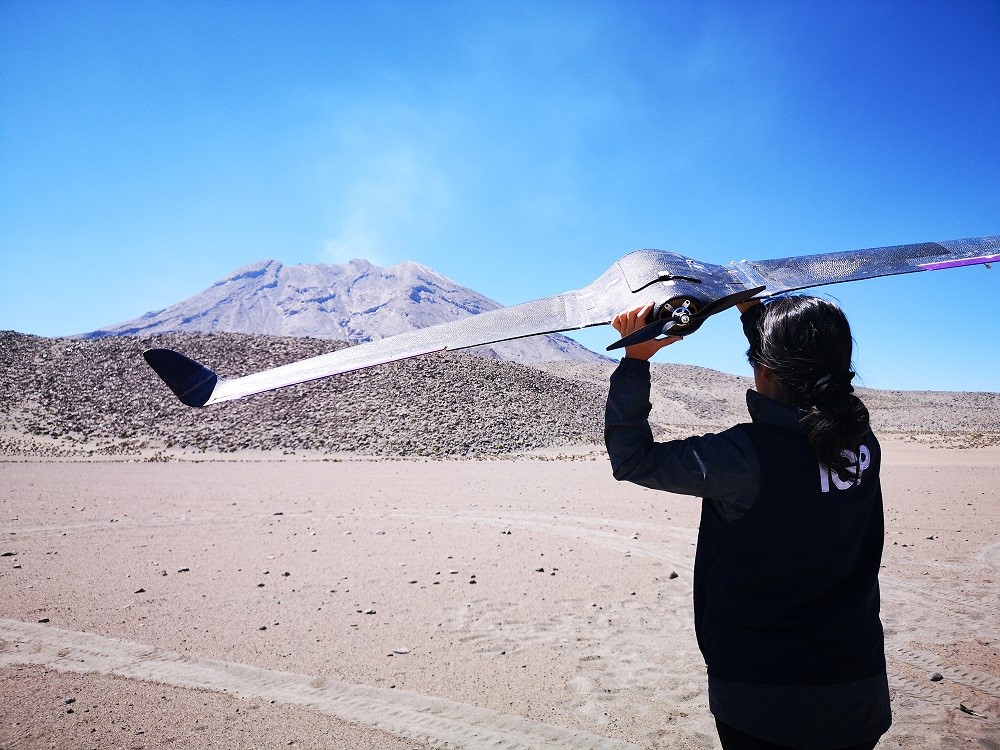 |
Figure 57. IGP flew a fixed-wing drone over Ubinas as part of their monitoring efforts. This photograph shows gas emissions rising from the summit crater, published on 7 October 2019. Courtesy of IGP. |
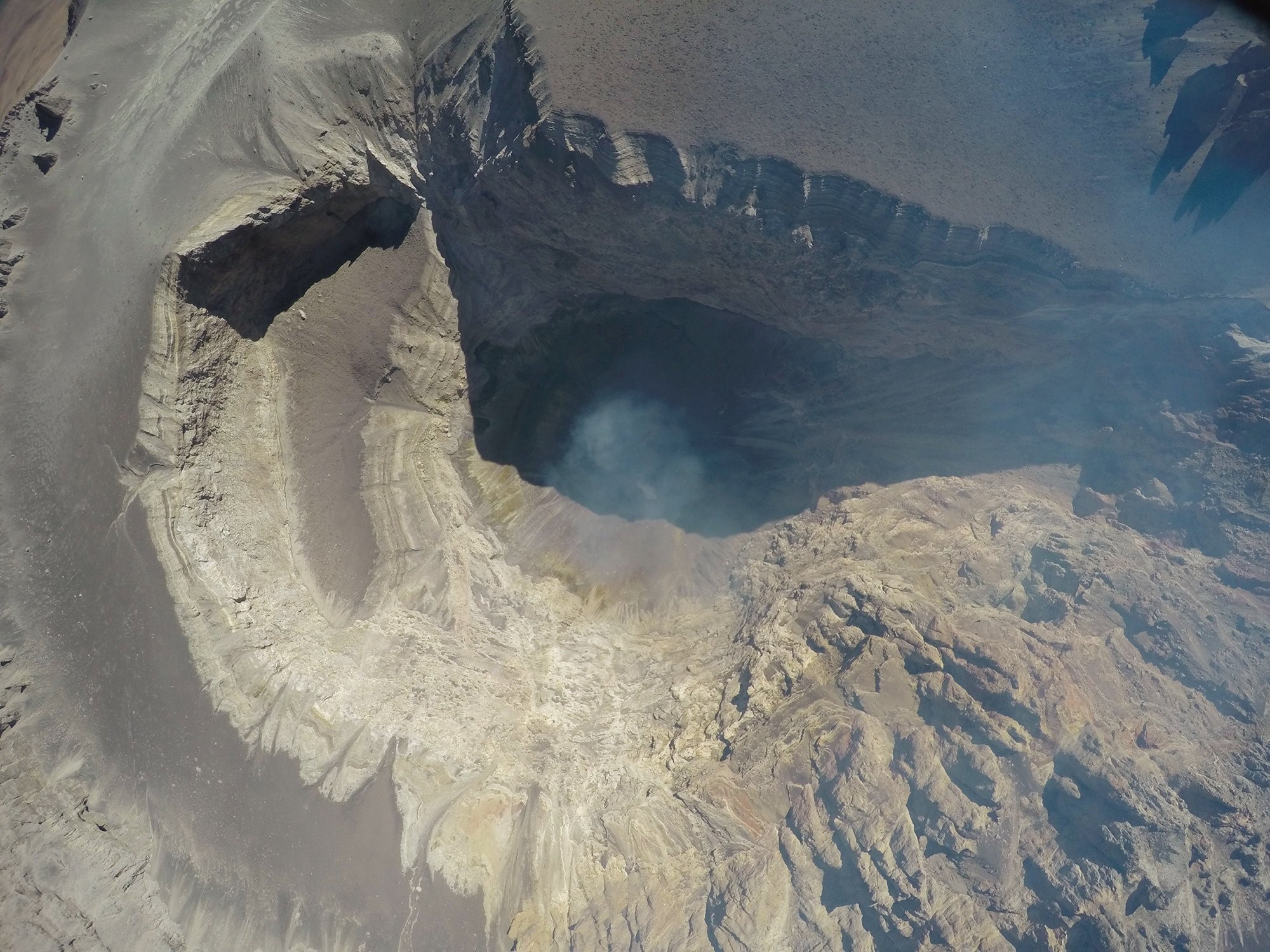 |
Figure 58. Drone image showing gas emissions and the summit crater of Ubinas. Image taken by IGP staff and released on 7 October 2019; courtesy of IGP. |
Similar activity continued through early November with no reported explosions, and the thermal anomalies were no longer detected at the end of November (figure 59), although a faint thermal anomaly was visible in Sentinel-2 data in mid-December (figure 60). A rockfall occurred at 1138 on 13 November down the Volcanmayo gorge.
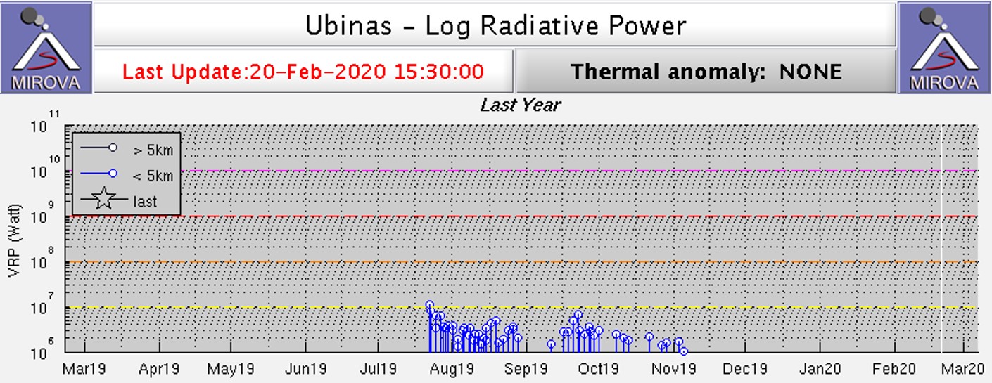 |
Figure 59. This MIROA Log Radiative Power plot shows increased thermal energy detected at Ubinas during August through November 2019. Courtesy of MIROVA. |
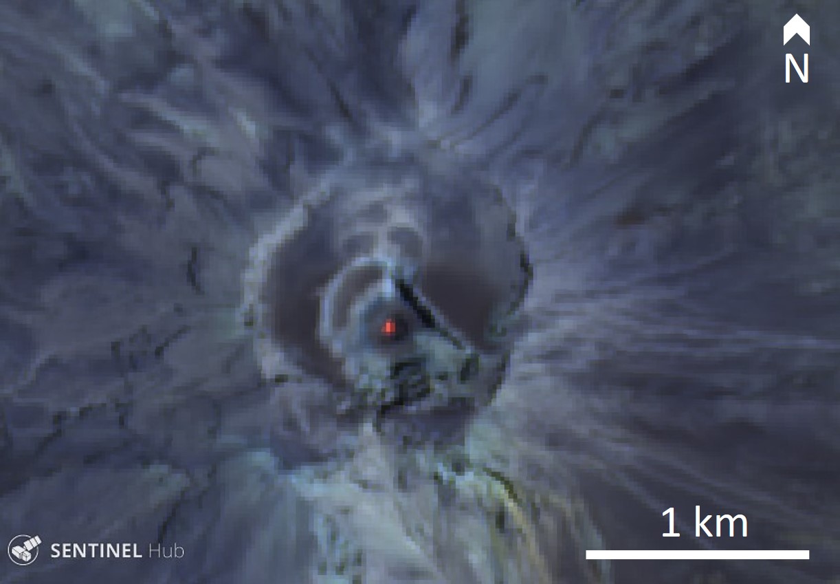 |
Figure 60. Sentinel-2 thermal satellite image showing elevated temperatures in the Ubinas crater on 16 December 2019. Courtesy of Sentinel Hub Playground. |
There were no explosions during January or February 2020, with seismicity and reduced gas emissions continuing. There was a small- to moderate-volume lahar generated at 1620 on 4 January down the SE flank. A second moderate- to high-volume lahar was generated at 1532 on 24 February, and three more lahars at 1325 and 1500 on 29 February, and at 1601 on 1 March, moved down the Volcanmayo gorge and the Sacohaya river channel. The last three lahars were of moderate to large volume.
Geological Summary. The truncated appearance of Ubinas, Perú's most active volcano, is a result of a 1.4-km-wide crater at the summit. It is the northernmost of three young volcanoes located along a regional structural lineament about 50 km behind the main volcanic front. The growth and destruction of Ubinas I was followed by construction of Ubinas II beginning in the mid-Pleistocene. The upper slopes of the andesitic-to-rhyolitic Ubinas II stratovolcano are composed primarily of andesitic and trachyandesitic lava flows and steepen to nearly 45°. The steep-walled, 150-m-deep summit crater contains an ash cone with a 500-m-wide funnel-shaped vent that is 200 m deep. Debris-avalanche deposits from the collapse of the SE flank about 3,700 years ago extend 10 km from the volcano. Widespread Plinian pumice-fall deposits include one from about 1,000 years ago. Holocene lava flows are visible on the flanks, but activity documented since the 16th century has consisted of intermittent minor-to-moderate explosive eruptions.
Information Contacts: Observatorio Volcanologico del INGEMMET (Instituto Geológical Minero y Metalúrgico), Barrio Magisterial Nro. 2 B-16 Umacollo - Yanahuara Arequipa, Peru (URL: http://ovi.ingemmet.gob.pe); Instituto Geofisico del Peru (IGP), Calle Badajoz N° 169 Urb. Mayorazgo IV Etapa, Ate, Lima 15012, Perú (URL: https://www.gob.pe/igp); MIROVA (Middle InfraRed Observation of Volcanic Activity), a collaborative project between the Universities of Turin and Florence (Italy) supported by the Centre for Volcanic Risk of the Italian Civil Protection Department (URL: http://www.mirovaweb.it/); Planet Labs, Inc. (URL: https://www.planet.com/); Sentinel Hub Playground (URL: https://www.sentinel-hub.com/explore/sentinel-playground).