Report on Copahue (Chile-Argentina) — March 2020

Bulletin of the Global Volcanism Network, vol. 45, no. 3 (March 2020)
Managing Editor: Edward Venzke.
Edited by A. Elizabeth Crafford.
Copahue (Chile-Argentina) Ash emissions end on 12 November; lake returns to El Agrio Crater in December 2019
Please cite this report as:
Global Volcanism Program, 2020. Report on Copahue (Chile-Argentina) (Crafford, A.E., and Venzke, E., eds.). Bulletin of the Global Volcanism Network, 45:3. Smithsonian Institution. https://doi.org/10.5479/si.GVP.BGVN202003-357090
Copahue
Chile-Argentina
37.856°S, 71.183°W; summit elev. 2953 m
All times are local (unless otherwise noted)
Most of the large edifice of Copahue lies high in the central Chilean Andes, but the active El Agrio crater lies on the Argentinian side of the border at the W edge of the Pliocene Caviahue caldera. Infrequent mild-to-moderate explosive eruptions have been recorded since the 18th century. The most recent eruptive episode began with phreatic explosions and ash emissions on 2 August 2019 that continued until mid-November 2019. This report summarizes activity from November 2019 through February 2020 and is based on reports issued by Servicio Nacional de Geología y Minería (SERNAGEOMIN) Observatorio Volcanológico de Los Andes del Sur (OVDAS), Buenos Aires Volcanic Ash Advisory Center (VAAC), satellite data, and photographs from nearby residents.
MIROVA data indicated a few weak thermal anomalies during mid-October to mid-November 2019. Multiple continuous ash emissions were reported daily until mid-November when activity declined significantly. By mid-December the lake inside El Agrio crater had reappeared and occasional steam plumes were the only reported surface activity at Copahue through February 2020.
The Buenos Aires VAAC and SERNAGEOMIN both reported continuous ash emissions during 1-9 November 2019 that were visible in the webcam. Satellite imagery recorded the plumes drifting generally E or NE at 3.0-4.3 km altitude (figure 49). Most of the emissions on 10 November were steam (figure 50). The last pulse of ash emissions occurred on 12 November with an ash plume visible moving SE at 3 km altitude in satellite imagery and a strong thermal anomaly (figure 51). The following day emissions were primarily steam and gas. SERNAGEOMIN noted the ash emissions rising around 800 m above El Agrio crater and also reported incandescence visible during most nights through mid-November. During the second half of November the constant degassing was primarily water vapor with occasional nighttime incandescence. Steam plumes rose 450 m above the crater on 27 November.
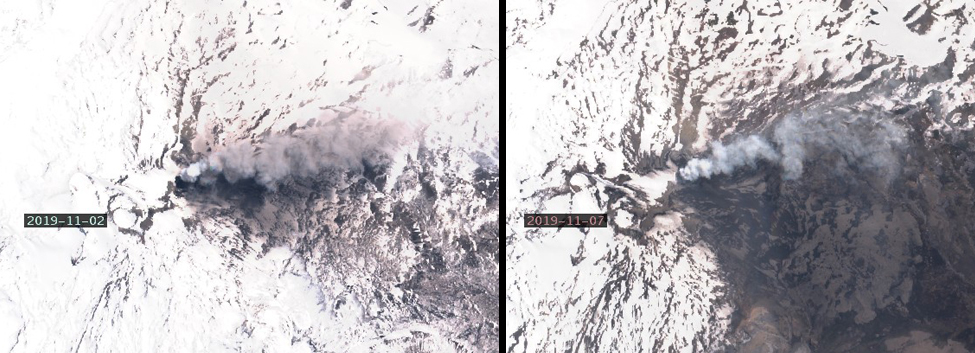 |
Figure 49. Continuous ash emissions at Copahue during 1-9 November 2019 were visible in Sentinel-2 satellite imagery on 2 and 7 November 2019 drifting NE. Natural color rendering uses bands 4,3, and 2. Courtesy of Sentinel Hub Playground. |
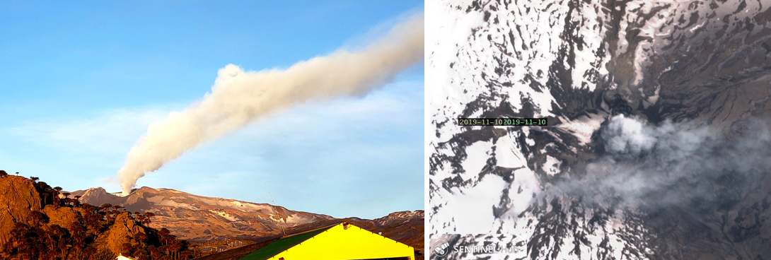 |
Figure 50. Most of the emissions from Copahue on 10 November 2019 were steam. Left image courtesy of Valentina Sepulveda, taken from Caviahue, Argentina. Right image courtesy of Sentinel Hub Playground, natural color rendering using bands 4, 3, and 2. |
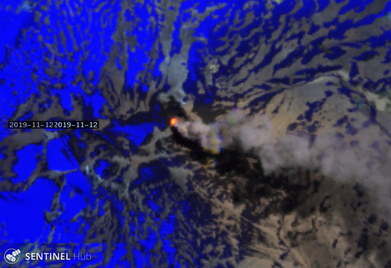 |
Figure 51. A strong thermal anomaly and an ash plume at Copahue were visible in Sentinel-2 satellite imagery on 12 November 2019. Courtesy of Sentinel Hub Playground, Atmospheric penetration rendering bands 12, 11, and 8A. |
Nighttime incandescence was last observed in the SERNAGEOMIN webcam on 1 December; SERNAGEOMIN lowered the alert level from Yellow to Green on 15 December 2019. Throughout December degassing consisted mainly of minor steam plumes (figure 52), the highest plume rose to 300 m above the crater on 18 December, and minor SO2 plumes persisted through the 21st (figure 53),. By mid-December the El Agrio crater lake was returning and satellite images clearly showed the increase in size of the lake through February (figure 54). The only surface activity reported during January and February 2020 was occasional white steam plumes rising near El Agrio crater.
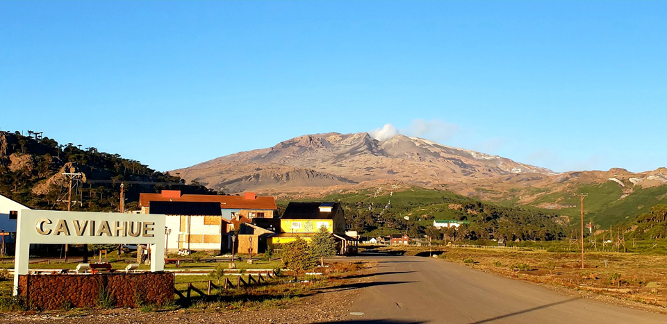 |
Figure 52. Small wisps of steam were the only emissions from Copahue on 3 December 2019. Courtesy of Valentina Sepulveda, taken from Caviahue, Argentina. |
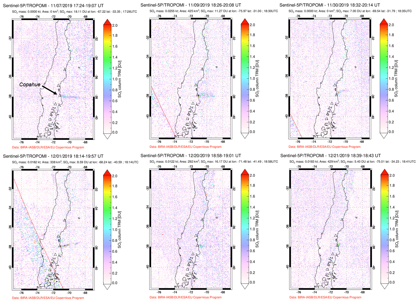 |
Figure 53. Small plumes of SO2 were recorded at Copahue during November and December 2019. Top row: 7, 9, and 30 November. Bottom row: 1, 20, and 21 December. Courtesy of Global Sulfur Dioxide Monitoring Page, NASA. |
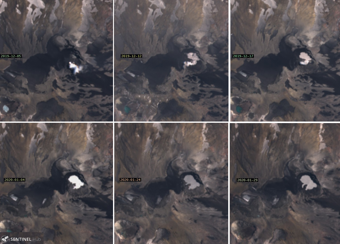 |
Figure 54. The lake within El Agrio crater reappeared between 5 and 12 December 2019 and continued to grow in size through the end of January 2020. Top row (left to right): There was no lake inside the crater on 5 December 2019, only a small steam plume rising from the vent. The first water was visible on 12 December and was slightly larger a few days later on 17 December. Bottom row (left to right): the lake was significantly larger on 4 January 2020 filling an embayment close to the steam vent. Fingers of water filled in areas of the crater as the water level rose on 24 and 29 January. Courtesy of Sentinel Hub Playground. |
Geological Summary. Volcán Copahue is an elongated composite cone constructed along the Chile-Argentina border within the 6.5 x 8.5 km wide Trapa-Trapa caldera that formed between 0.6 and 0.4 million years ago near the NW margin of the 20 x 15 km Pliocene Caviahue (Del Agrio) caldera. The eastern summit crater, part of a 2-km-long, ENE-WSW line of nine craters, contains a briny, acidic 300-m-wide crater lake (also referred to as El Agrio or Del Agrio) and displays intense fumarolic activity. Acidic hot springs occur below the eastern outlet of the crater lake, contributing to the acidity of the Río Agrio, and another geothermal zone is located within Caviahue caldera about 7 km NE of the summit. Infrequent mild-to-moderate explosive eruptions have been recorded since the 18th century. Twentieth-century eruptions from the crater lake have ejected pyroclastic rocks and chilled liquid sulfur fragments.
Information Contacts: Servicio Nacional de Geología y Minería (SERNAGEOMIN), Observatorio Volcanológico de Los Andes del Sur (OVDAS), Avda Sta María No. 0104, Santiago, Chile (URL: http://www.sernageomin.cl/); MIROVA (Middle InfraRed Observation of Volcanic Activity), a collaborative project between the Universities of Turin and Florence (Italy) supported by the Centre for Volcanic Risk of the Italian Civil Protection Department (URL: http://www.mirovaweb.it/); Sentinel Hub Playground (URL: https://www.sentinel-hub.com/explore/sentinel-playground); Global Sulfur Dioxide Monitoring Page, Atmospheric Chemistry and Dynamics Laboratory, NASA Goddard Space Flight Center (NASA/GSFC), 8800 Greenbelt Road, Goddard, Maryland, USA (URL: https://so2.gsfc.nasa.gov/); Valentina Sepulveda, Hotel Caviahue, Caviahue, Argentina (URL: https://twitter.com/valecaviahue, Twitter:@valecaviahue).