Report on Merapi (Indonesia) — April 2020

Bulletin of the Global Volcanism Network, vol. 45, no. 4 (April 2020)
Managing Editor: Edward Venzke.
Edited by Kadie L. Bennis.
Merapi (Indonesia) Explosions produced ash plumes, ashfall, and pyroclastic flows during October 2019-March 2020
Please cite this report as:
Global Volcanism Program, 2020. Report on Merapi (Indonesia) (Bennis, K.L., and Venzke, E., eds.). Bulletin of the Global Volcanism Network, 45:4. Smithsonian Institution. https://doi.org/10.5479/si.GVP.BGVN202004-263250
Merapi
Indonesia
7.54°S, 110.446°E; summit elev. 2910 m
All times are local (unless otherwise noted)
Merapi is a highly active stratovolcano located in Indonesia, just north of the city of Yogyakarta. The current eruption episode began in May 2018 and was characterized by phreatic explosions, ash plumes, block avalanches, and a newly active lava dome at the summit. This reporting period updates information from October 2019-March 2020 that includes explosions, pyroclastic flows, ash plumes, and ashfall. The primary reporting source of activity comes from Balai Penyelidikan dan Pengembangan Teknologi Kebencanaan Geologi (BPPTKG, the Center for Research and Development of Geological Disaster Technology, a branch of PVMBG) and Pusat Vulkanologi dan Mitigasi Bencana Geologi (PVMBG, also known as Indonesian Center for Volcanology and Geological Hazard Mitigation, CVGHM).
Some ongoing lava dome growth continued in October 2019 in the NE-SW direction measuring 100 m in length, 30 m in width, and 20 m in depth. Gas-and-steam emissions were frequent, reaching a maximum height of 700 m above the crater on 31 October. An explosion at 1631 on 14 October removed the NE-SW trending section of the lava dome and produced an ash plume that rose 3 km above the crater and extended SW for about 2 km (figures 90 and 91). The plume resulted in ashfall as far as 25 km to the SW. According to a Darwin VAAC notice, a thermal hotspot was detected in HIMAWARI-8 satellite imagery. A pyroclastic flow associated with the eruption traveled down the SW flank in the Gendol drainage. During 14-20 October lava flows from the crater generated block-and-ash flows that traveled 1 km SW, according to BPPTKG.
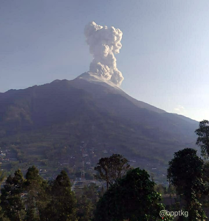 |
Figure 90. An ash plume rising 3 km above Merapi on 14 October 2019. Courtesy of BPPTKG. |
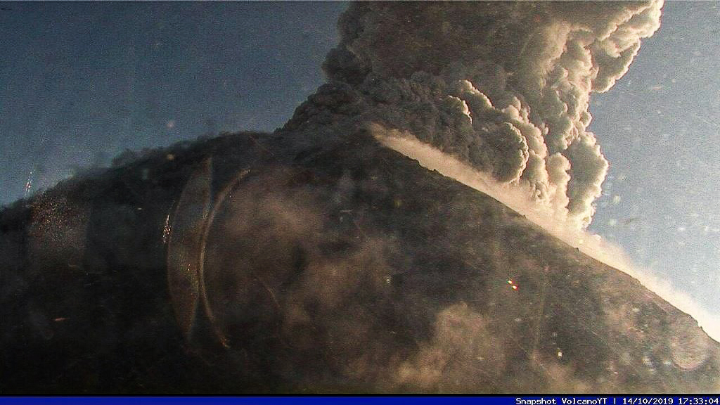 |
Figure 91. Webcam image of an ash plume rising above Merapi at 1733 on 14 October 2019. Courtesy of BPPTKG via Jaime S. Sincioco. |
At 0621 on 9 November 2019, an eruption produced an ash plume that rose 1.5 km above the crater and drifted W. Ashfall was observed in the W region as far as 15 km from the summit in Wonolelo and Sawangan in Magelang Regency, as well as Tlogolele and Selo in Boyolali Regency. An associated pyroclastic flow traveled 2 km down the Gendol drainage on the SE flank. On 12 November aerial drone photographs were used to measure the volume of the lava dome, which was 407,000 m3. On 17 November, an eruption produced an ash plume that rose 1 km above the crater, resulting in ashfall as far as 15 km W from the summit in the Dukun District, Magelang Regency (figure 92). A pyroclastic flow accompanying the eruption traveled 1 km down the SE flank in the Gendol drainage. By 30 November low-frequency earthquakes and CO2 gas emissions had increased.
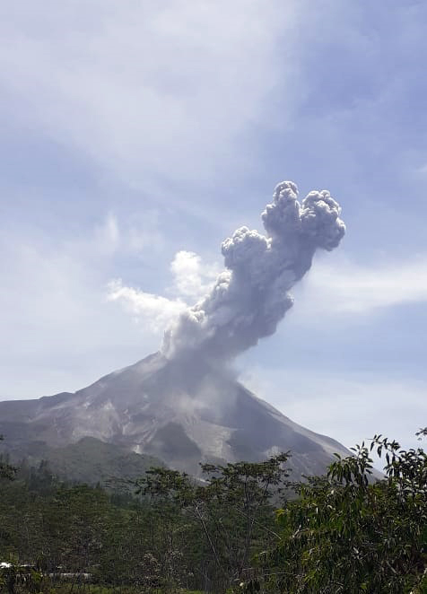 |
Figure 92. An ash plume rising 1 km above Merapi on 17 November 2019. Courtesy of BPPTKG. |
Volcanism was relatively low from 18 November 2019 through 12 February 2020, characterized primarily by gas-and-steam emissions and intermittent volcanic earthquakes. On 4 January a pyroclastic flow was recorded by the seismic network at 2036, but it wasn’t observed due to weather conditions. On 13 February an explosion was detected at 0516, which ejected incandescent material within a 1-km radius from the summit (figure 93). Ash plumes rose 2 km above the crater and drifted NW, resulting in ashfall within 10 km, primarily S of the summit; lightning was also seen in the plume. Ash was observed in Hargobinangun, Glagaharjo, and Kepuharjo. On 19 February aerial drone photographs were used to measure the change in the lava dome after the eruption; the volume of the lava had decreased, measuring 291,000 m3.
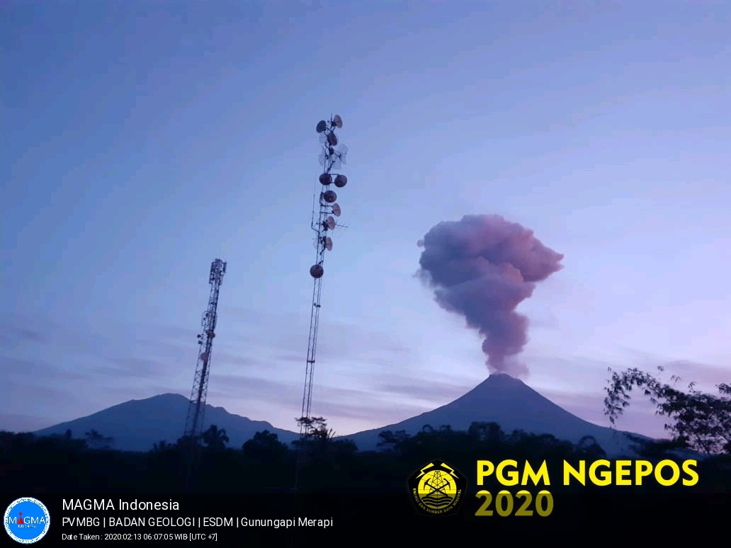 |
Figure 93. Webcam image of an ash plume rising from Merapi at 0516 on 13 February 2020. Courtesy of MAGMA Indonesia and PVMBG. |
An explosion on 3 March at 0522 produced an ash plume that rose 6 km above the crater (figure 94), resulting in ashfall within 10 km of the summit, primarily to the NE in the Musuk and Cepogo Boyolali sub-districts and Mriyan Village, Boyolali (3 km from the summit). A pyroclastic flow accompanied this eruption, traveling down the SSE flank less than 2 km. Explosions continued to be detected on 25 and 27-28 March, resulting in ash plumes. The eruption on 27 March at 0530 produced an ash plume that rose 5 km above the crater, causing ashfall as far as 20 km to the W in the Mungkid subdistrict, Magelang Regency, and Banyubiru Village, Dukun District, Magelang Regency. An associated pyroclastic flow descended the SSE flank, traveling as far as 2 km. The ash plume from the 28 March eruption rose 2 km above the crater, causing ashfall within 5 km from the summit in the Krinjing subdistrict primarily to the W (figure 94).
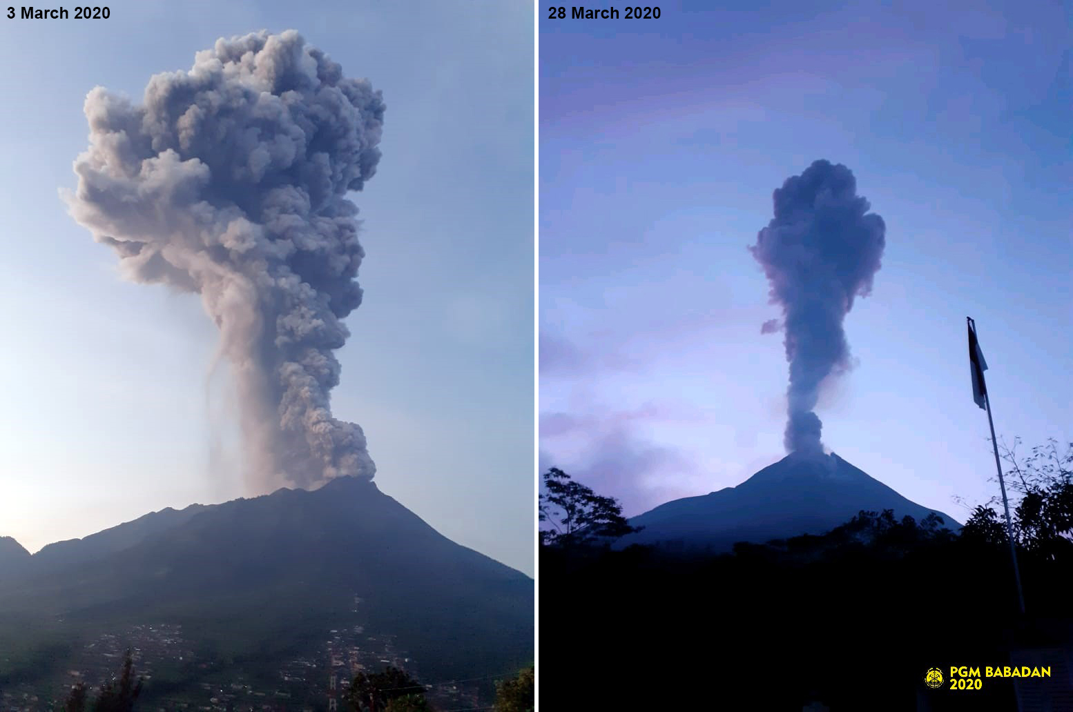 |
Figure 94. Images of ash plumes rising from Merapi during 3 March (left) and 28 March 2020 (right). Images courtesy of BPPTKG (left) and PVMBG (right). |
Geological Summary. Merapi, one of Indonesia's most active volcanoes, lies in one of the world's most densely populated areas and dominates the landscape immediately north of the major city of Yogyakarta. It is the youngest and southernmost of a volcanic chain extending NNW to Ungaran volcano. Growth of Old Merapi during the Pleistocene ended with major edifice collapse perhaps about 2,000 years ago, leaving a large arcuate scarp cutting the eroded older Batulawang volcano. Subsequent growth of the steep-sided Young Merapi edifice, its upper part unvegetated due to frequent activity, began SW of the earlier collapse scarp. Pyroclastic flows and lahars accompanying growth and collapse of the steep-sided active summit lava dome have devastated cultivated lands on the western-to-southern flanks and caused many fatalities.
Information Contacts: Balai Penyelidikan dan Pengembangan Teknologi Kebencanaan Geologi (BPPTKG), Center for Research and Development of Geological Disaster Technology (URL: http://merapi.bgl.esdm.go.id/, Twitter: @BPPTKG); Pusat Vulkanologi dan Mitigasi Bencana Geologi (PVMBG, also known as Indonesian Center for Volcanology and Geological Hazard Mitigation, CVGHM), Jalan Diponegoro 57, Bandung 40122, Indonesia (URL: http://www.vsi.esdm.go.id/); Badan Nasional Penanggulangan Bencana (BNPB), National Disaster Management Agency, Graha BNPB - Jl. Scout Kav.38, East Jakarta 13120, Indonesia (URL: http://www.bnpb.go.id/, Twitter: https://twitter.com/BNPB_Indonesia); MAGMA Indonesia, Kementerian Energi dan Sumber Daya Mineral (URL: https://magma.vsi.esdm.go.id/); Darwin Volcanic Ash Advisory Centre (VAAC), Bureau of Meteorology, Northern Territory Regional Office, PO Box 40050, Casuarina, NT 0811, Australia (URL: http://www.bom.gov.au/info/vaac/); Jamie S. Sincioco, Phillipines (Twitter: @jaimessincioco, Image at https://twitter.com/jaimessincioco/status/1227966075519635456/photo/1).