Report on Villarrica (Chile) — April 2020

Bulletin of the Global Volcanism Network, vol. 45, no. 4 (April 2020)
Managing Editor: Edward Venzke.
Edited by A. Elizabeth Crafford.
Villarrica (Chile) Brief increase in explosions, mid-September 2019; continued thermal activity through February 2020
Please cite this report as:
Global Volcanism Program, 2020. Report on Villarrica (Chile) (Crafford, A.E., and Venzke, E., eds.). Bulletin of the Global Volcanism Network, 45:4. Smithsonian Institution. https://doi.org/10.5479/si.GVP.BGVN202004-357120
Villarrica
Chile
39.42°S, 71.93°W; summit elev. 2847 m
All times are local (unless otherwise noted)
Historical eruptions at Chile's Villarrica, documented since 1558, have consisted largely of mild-to-moderate explosive activity with occasional lava effusion. An intermittently active lava lake at the summit has been the source of Strombolian activity, incandescent ejecta, and thermal anomalies for several decades; the current eruption has been ongoing since December 2014. Continuing activity during September 2019-February 2020 is covered in this report, with information provided by the Southern Andes Volcano Observatory (Observatorio Volcanológico de Los Andes del Sur, OVDAS), part of Chile's National Service of Geology and Mining (Servicio Nacional de Geología y Minería, SERNAGEOMIN), and Projecto Observación Villarrica Internet (POVI), part of the Fundacion Volcanes de Chile, a research group that studies volcanoes across Chile.
A brief period of heighted explosive activity in early September 2019 caused SERNAGEOMIN to raise the Alert Level from Yellow to Orange (on a four-color scale of Green-Yellow-Orange-Red) for several days. Increases in radiative power were visible in the MIROVA thermal anomaly data during September (figure 84). Although overall activity decreased after that, intermittent explosions were observed at the summit, and incandescence continued throughout September 2019-February 2020. Sentinel-2 satellite imagery indicated a strong thermal anomaly from the summit crater whenever the weather conditions permitted. In addition, ejecta periodically covered the area around the summit crater, and particulates often covered the snow beneath the narrow gas plume drifting S from the summit (figure 85).
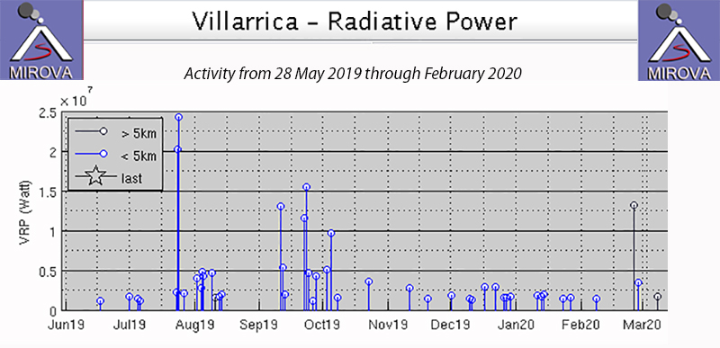 |
Figure 84. Thermal activity at Villarrica from 28 May 2019 through February 2020 was generally at a low level, except for brief periods in August and September 2019 when larger explosions were witnessed and recorded in seismic data and higher levels of thermal activity were noted by the MIROVA project. Courtesy of MIROVA. |
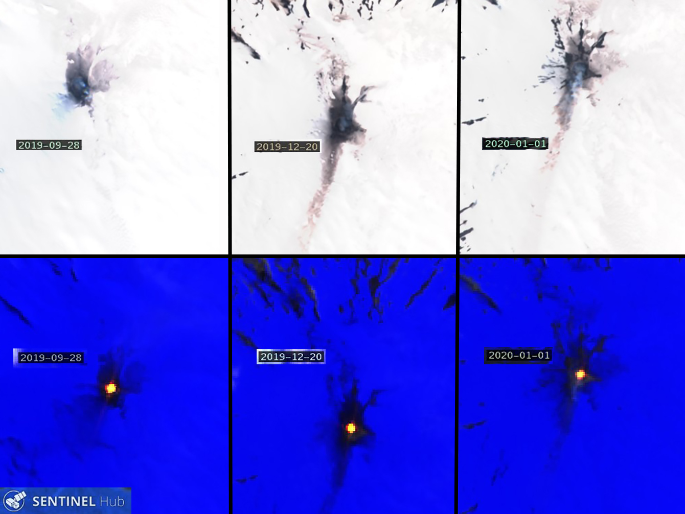 |
Figure 85. Natural-color (top) and Atmospheric penetration (bottom) renderings of three different dates during September 2019-February 2020 show typical continued activity at Villarica during the period. Dark ejecta periodically covered the snow around the summit crater, and streaks of particulate material were sometimes visible on the snow underneath the plumes of bluish gas drifting S from the volcano (top images). Persistent thermal anomalies were recorded in infrared satellite data on the same dates (bottom images). Dates recorded are (left to right) 28 September 2019, 20 December 2019, and 1 January 2020. Natural color rendering uses bands 4,3, and 2, and Atmospheric penetration rendering uses bands 12, 11, and 8a. Courtesy of Sentinel Hub Playground. |
SERNAGEOMIN raised the Alert Level from Green to Yellow in early August 2019 due to the increase in activity that included incandescent ejecta and bombs reaching 200 m from the summit crater (BGVN 44:09). An increase in seismic tremor activity on 8 September was accompanied by vigorous Strombolian explosions reported by POVI. The following day, SERNAGEOMIN raised the Alert Level from Yellow to Orange. Poor weather prevented visual observations of the summit on 8 and 9 September, but high levels of incandescence were observed briefly on 10 September. Incandescent ejecta reached 200 m from the crater rim late on 10 September (figure 86). Activity increased the next day with ejecta recorded 400 m from the crater, and the explosions were felt 12 km from the summit.
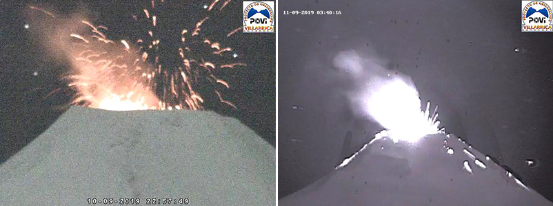 |
Figure 86. A new pulse of activity at Villarrica reached its maximum on 10 (left) and 11 (right) September 2019. Incandescent ejecta reached 200 m from the crater rim on 10 September and up to 400 m the following day. Courtesy of POVI (Volcan Villarrica, Resumen grafico del comportamiento, Septiembre 2019 a enero 2020). |
Explosions decreased in intensity by 13 September, but avalanches of incandescent material were visible on the E flank in the early morning hours (figure 87). Small black plumes later in the day were interpreted by POVI as the result of activity from landslides within the crater. Fine ash deposited on the N and NW flanks during 16-17 September was attributed to wind moving ash from within the crater, and not to new emissions from the crater (figure 88). SERNAGEOMIN lowered the Alert Level to Yellow on 16 September as tremor activity decreased significantly. Activity continued to decrease during the second half of September; incandescence was moderate with no avalanches observed, and intermittent emissions with small amounts of material were noted. Degassing of steam plumes rose up to 120 m above the crater.
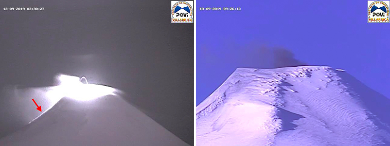 |
Figure 87. By 13 September 2019, a decrease in activity at Villarrica was apparent. Incandescence (red arrow) was visible on the E flank of Villarrica early on 13 September (left). Fine ash, likely from small collapses of new material inside the vent, rose a short distance above the summit later in the day (right). Courtesy of POVI (Volcan Villarrica, Resumen grafico del comportamiento, Septiembre 2019 a Enero 2020). |
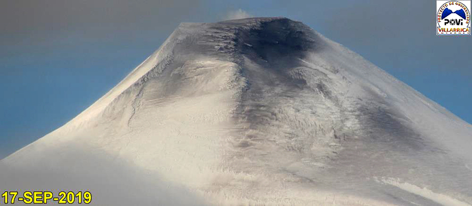 |
Figure 88. Fine-grained material covered the summit of Villarrica on 17 September 2019. POVI interpreted this as a result of strong winds moving fine ash-sized particles from within the crater and depositing them on the N and NW flanks. Courtesy of POVI (Volcan Villarrica, Resumen grafico del comportamiento, Septiembre 2019 a enero 2020). |
Low-altitude degassing was typical activity during October-December 2019; occasionally steam and gas plumes rose 300 m above the summit, but they were generally less than 200 m high. Incandescence was visible at night when weather conditions permitted. Occasional Strombolian explosions were observed in the webcam (figure 89). During January and February 2020, similar activity was reported with steam plumes observed to heights of 300-400 m above the summit, and incandescence on nights where the summit was visible (figure 90). A drone overflight on 19 January produced a clear view into the summit crater revealing a 5-m-wide lava pit about 120 m down inside the crater (figure 91).
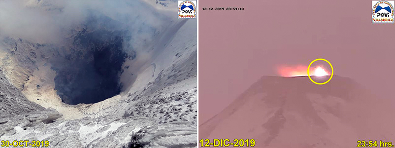 |
Figure 89. Activity continued at a lower level at the summit of Villarrica from October-December 2019. The 30-m-wide vent at the bottom of the summit crater (120 m deep) of Villarrica (left) was emitting wisps of bluish gas on 30 October 2019. Sporadic Strombolian explosions ejected material around the crater rim on 12 December (right). Courtesy of POVI (Volcan Villarrica, Resumen grafico del comportamiento, Septiembre 2019 a enero 2020). |
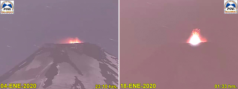 |
Figure 90. Small explosive events were recorded at Villarrica during January and February 2020, including these events on 4 (left) and 18 (right) January where ejecta reached about 50 m above the crater rim. Courtesy of POVI (Volcan Villarrica, Resumen grafico del comportamiento, Septiembre 2019 a Enero 2020). |
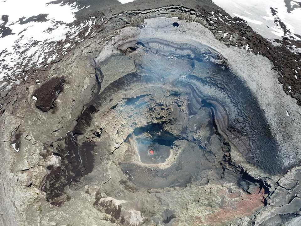 |
Figure 91. An oblique view into the bottom of the summit crater of Villarrica on 19 January 2020 was captured by drone. The diameter of the lava pit was calculated at about 5 m and was about 120 m deep. Image copyright by Leighton M. Watson, used with permission; courtesy of POVI (Volcan Villarrica, Resumen grafico del comportamiento, Septiembre 2019 a Enero 2020). |
Geological Summary. The glacier-covered Villarrica stratovolcano, in the northern Lakes District of central Chile, is ~15 km south of the city of Pucon. A 2-km-wide caldera that formed about 3,500 years ago is located at the base of the presently active, dominantly basaltic to basaltic andesite cone at the NW margin of a 6-km-wide Pleistocene caldera. More than 30 scoria cones and fissure vents are present on the flanks. Plinian eruptions and pyroclastic flows that have extended up to 20 km from the volcano were produced during the Holocene. Lava flows up to 18 km long have issued from summit and flank vents. Eruptions documented since 1558 CE have consisted largely of mild-to-moderate explosive activity with occasional lava effusion. Glaciers cover 40 km2 of the volcano, and lahars have damaged towns on its flanks.
Information Contacts: Servicio Nacional de Geología y Minería (SERNAGEOMIN), Observatorio Volcanológico de Los Andes del Sur (OVDAS), Avda Sta María No. 0104, Santiago, Chile (URL: http://www.sernageomin.cl/); Proyecto Observación Villarrica Internet (POVI) (URL: http://www.povi.cl/); MIROVA (Middle InfraRed Observation of Volcanic Activity), a collaborative project between the Universities of Turin and Florence (Italy) supported by the Centre for Volcanic Risk of the Italian Civil Protection Department (URL: http://www.mirovaweb.it/); Sentinel Hub Playground (URL: https://www.sentinel-hub.com/explore/sentinel-playground); Leighton M. Watson, Department of Earth Sciences at the University of Oregon, Eugene, OR 97403-1272, USA (URL: https://earthsciences.uoregon.edu/).