Report on Piton de la Fournaise (France) — May 2020

Bulletin of the Global Volcanism Network, vol. 45, no. 5 (May 2020)
Managing Editor: Edward Venzke.
Edited by Kadie L. Bennis. Research and preparation by Paul Berger.
Piton de la Fournaise (France) Fissure eruptions in February and April 2020 included lava fountains and flows
Please cite this report as:
Global Volcanism Program, 2020. Report on Piton de la Fournaise (France) (Bennis, K.L., and Venzke, E., eds.). Bulletin of the Global Volcanism Network, 45:5. Smithsonian Institution. https://doi.org/10.5479/si.GVP.BGVN202005-233020
Piton de la Fournaise
France
21.244°S, 55.708°E; summit elev. 2632 m
All times are local (unless otherwise noted)
Piton de la Fournaise is a massive basaltic shield volcano on the French island of Réunion in the western Indian Ocean. Recent volcanism is characterized by multiple fissure eruptions, lava fountains, and lava flows (BGVN 44:11). The activity during this reporting period of November 2019-April 2020 is consistent with the previous eruption, including lava fountaining and lava flows. Information for this report comes from the Observatoire Volcanologique du Piton de la Fournaise (OVPF) and various satellite data.
Activity during November 2019-January 2020 was relatively low; no eruptive events were detected, according to OVPF. Edifice deformation resumed during the last week in December and continued through January. Seismicity significantly increased in early January, registering 258 shallow earthquakes from 1-16 January. During 17-31 January, the seismicity declined, averaging one earthquake per day.
Two eruptive events took place during February-April 2020. OVPF reported that the first occurred from 10 to 16 February on the E and SE flanks of the Dolomieu Crater. The second took place during 2-6 April. Both eruptive events began with a sharp increase in seismicity accompanied by edifice inflation, followed by a fissure eruption that resulted in lava fountains and lava flows (figure 193). MIROVA (Middle InfraRed Observation of Volcanic Activity) analysis of MODIS satellite data showed the two eruptive events occurring during February-April 2020 (figure 194). Similarly, the MODVOLC algorithm reported 72 thermal signatures proximal to the summit crater from 12 February to 6 April. Both of these eruptive events were accompanied by SO2 emissions that were detected by the Sentinel-5P/TROPOMI instrument (figures 195 and 196).
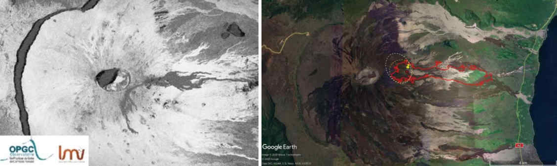 |
Figure 193. Location maps of the lava flows on the E flank at Piton de la Fournaise on 10-16 February 2020 (left) and 2-6 April 2020 (right) as derived from SAR satellite data. Courtesy of OVPF-IPGP, OPGC, LMV (Monthly bulletins of the Piton de la Fournaise Volcanological Observatory, February and April 2020). |
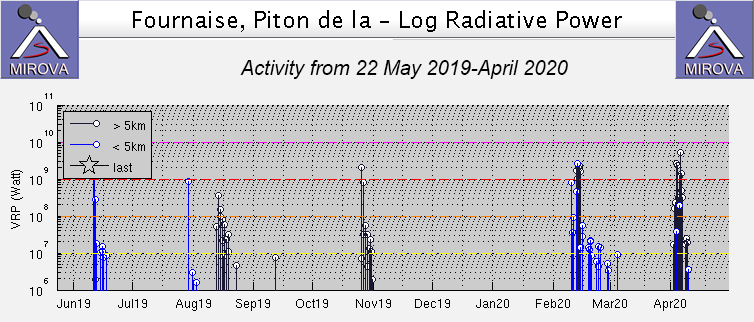 |
Figure 194. Two significant eruptive events at Piton de la Fournaise took place during February-April 2020 as recorded by the MIROVA system (Log Radiative Power). Courtesy of MIROVA. |
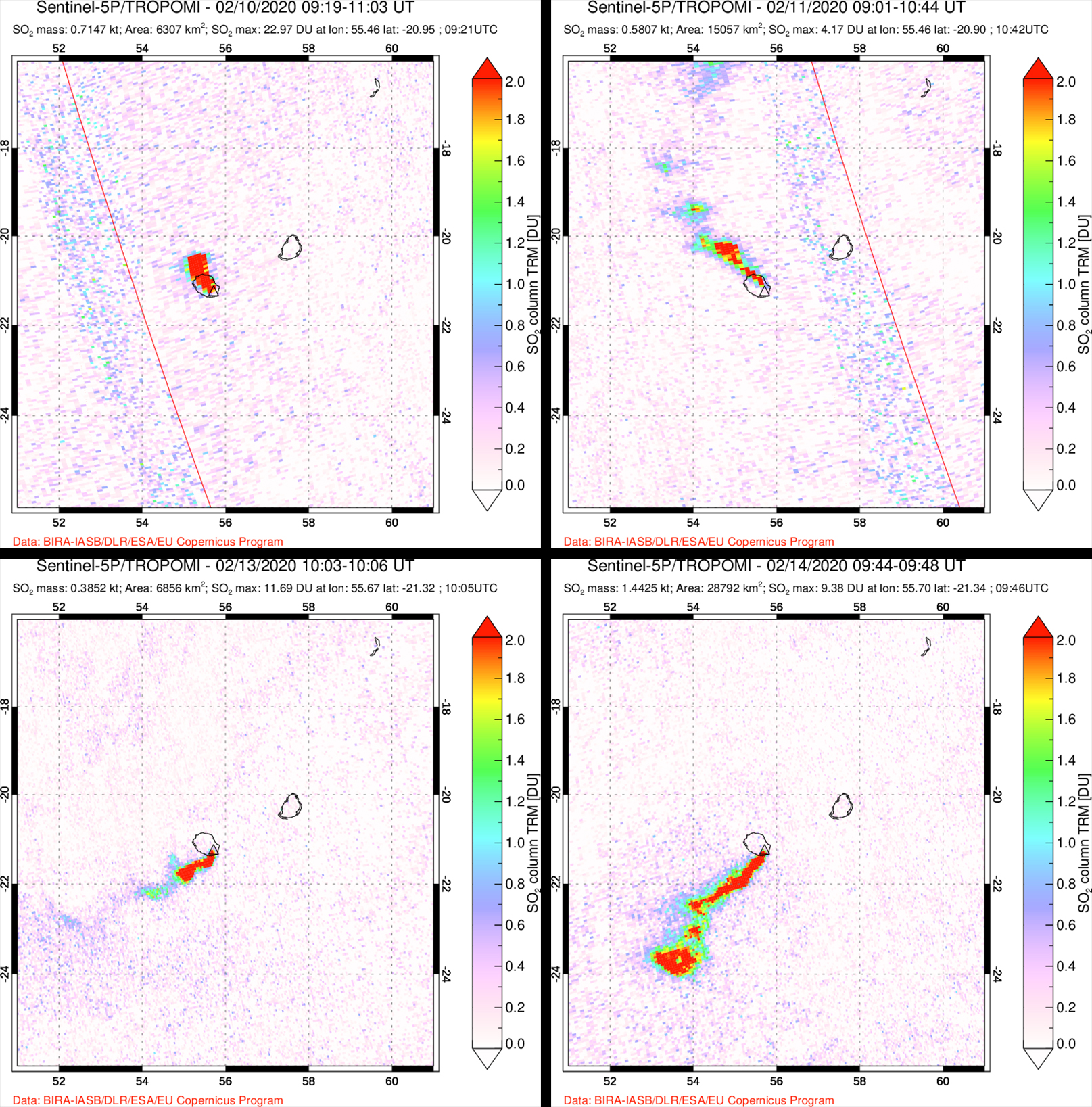 |
Figure 195. Images of the SO2 emissions during the February 2020 eruptive event at Piton de la Fournaise detected by the Sentinel-5P/TROPOMI satellite. Top left: 10 February 2020. Top right: 11 February 2020. Bottom left: 13 February 2020. Bottom right: 14 February 2020. Courtesy of NASA Global Sulfur Dioxide Monitoring Page. |
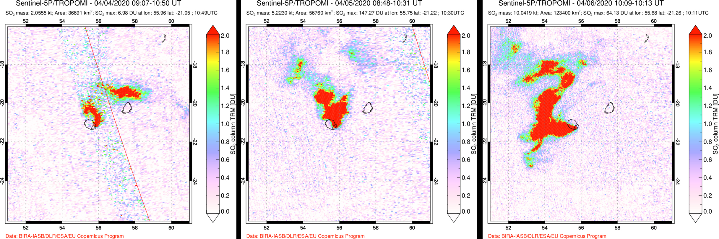 |
Figure 196. Images of the SO2 emissions during the April 2020 eruptive event at Piton de la Fournaise detected by the Sentinel-5P/TROPOMI satellite. Left: 4 April 2020. Middle: 5 April 2020. Right: 6 April 2020. Courtesy of NASA Global Sulfur Dioxide Monitoring Page. |
On 10 February 2020 a seismic swarm was detected at 1027, followed by rapid deformation. At 1050, volcanic tremors were recorded, signaling the start of the eruption. Several fissures opened on the E flank of the Dolomieu Crater between the crater rim and at 2,000 m elevation, as observed by an overflight during 1300 and 1330. These fissures were at least 1 km long and produced lava fountains that rose up to 10 m high. Lava flows were also observed traveling E and S to 1,700 m elevation by 1315 (figures 197 and 198). The farthest flow traveled E to an elevation of 1,400 m. Satellite data from HOTVOLC platform (OPGC - University of Auvergne) was used to estimate the peak lava flow rate on 11 February at 10 m3/s. By 13 February only one lava flow that was traveling E below the Marco Crater remained active. OVPF also reported the formation of a cone, measuring 30 m tall, surrounded by three additional vents that produced lava fountains up to 15 m high. On 15 February the volcanic tremors began to decrease at 1400; by 16 February at 1412 the tremors stopped, indicating the end of the eruptive event.
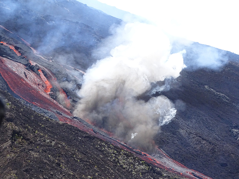 |
Figure 197. Photo of a lava flow and degassing at Piton de la Fournaise on 10 February 2020. Courtesy of OVPF-IPGP. |
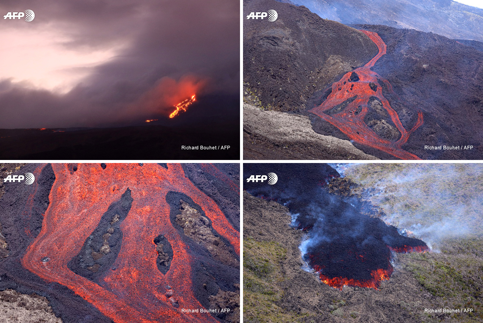 |
Figure 198. Photos of the lava flows at Piton de la Fournaise taken during the February 2020 eruption by Richard Bouchet courtesy of AFP News Service. |
Volcanism during the month of March 2020 consisted of low seismicity, including 21 shallow volcanic tremors and near the end of the month, edifice inflation was detected. A second eruptive event began on 2 April 2020, starting with an increase in seismicity during 0815-0851. Much of this seismicity was located on the SE part of the Dolomieu Crater. A fissure opened on the E flank, consistent with the fissures that were active during the February 2020 event. Seismicity continued to increase in intensity through 6 April located dominantly in the SE part of the Dolomieu Crater. An overflight on 5 April at 1030 showed lava fountains rising more than 50 m high accompanied by gas-and-steam plumes rising to 3-3.5 km altitude (figures 199 and 200). A lava flow advanced to an elevation of 360 m, roughly 2 km from the RN2 national road (figure 199). A significant amount of Pele’s hair and clusters of fine volcanic products were produced during the more intense phase of the eruption (5-6 April) and deposited at distances more than 10 km from the eruptive site (figure 201). It was also during this period that the SO2 emissions peaked (figure 196). The eruption stopped at 1330 after a sharp decrease in volcanic tremors.
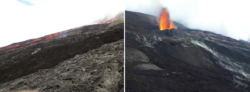 |
Figure 199. Photos of a lava flow (left) and lava fountains (right) at Piton de la Fournaise during the April 2020 eruption. Left: photo taken on 2 April 2020 at 1500. Right: photo taken on 5 April 2020 at 1030. Courtesy of OVPF-IPGP (Monthly bulletin of the Piton de la Fournaise Volcanological Observatory, April 2020). |
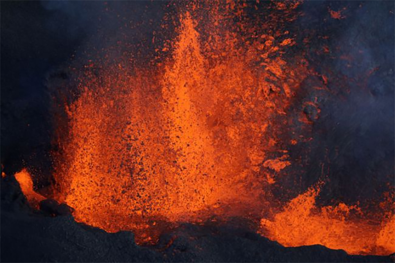 |
Figure 200. Photo of the lava fountains erupting from Piton de la Fournaise on 4 April 2020. Photo taken by Richard Bouchet courtesy of Geo Magazine via Jeannie Curtis. |
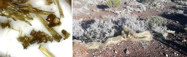 |
Figure 201. Photos of Pele’s hair deposited due to the April 2020 eruption at Piton de la Fournaise. Samples collected near the Gîte du volcan on 7 April 2020 (left) and a cluster of Pele’s hair found near the Foc-Foc car park on 9 April 2020 (right). Courtesy of OVPF-IPGP (Monthly bulletin of the Piton de la Fournaise Volcanological Observatory, April 2020). |
Geological Summary. Piton de la Fournaise is a massive basaltic shield volcano on the French island of Réunion in the western Indian Ocean. Much of its more than 530,000-year history overlapped with eruptions of the deeply dissected Piton des Neiges shield volcano to the NW. Three scarps formed at about 250,000, 65,000, and less than 5,000 years ago by progressive eastward slumping, leaving caldera-sized embayments open to the E and SE. Numerous pyroclastic cones are present on the floor of the scarps and their outer flanks. Most recorded eruptions have originated from the summit and flanks of Dolomieu, a 400-m-high lava shield that has grown within the youngest scarp, which is about 9 km wide and about 13 km from the western wall to the ocean on the E side. More than 150 eruptions, most of which have produced fluid basaltic lava flows, have occurred since the 17th century. Only six eruptions, in 1708, 1774, 1776, 1800, 1977, and 1986, have originated from fissures outside the scarps.
Information Contacts: Observatoire Volcanologique du Piton de la Fournaise, Institut de Physique du Globe de Paris, 14 route nationale 3, 27 ème km, 97418 La Plaine des Cafres, La Réunion, France (URL: http://www.ipgp.fr/fr); MIROVA (Middle InfraRed Observation of Volcanic Activity), a collaborative project between the Universities of Turin and Florence (Italy) supported by the Centre for Volcanic Risk of the Italian Civil Protection Department (URL: http://www.mirovaweb.it/); Hawai'i Institute of Geophysics and Planetology (HIGP) - MODVOLC Thermal Alerts System, School of Ocean and Earth Science and Technology (SOEST), Univ. of Hawai'i, 2525 Correa Road, Honolulu, HI 96822, USA (URL: http://modis.higp.hawaii.edu/); Global Sulfur Dioxide Monitoring Page, Atmospheric Chemistry and Dynamics Laboratory, NASA Goddard Space Flight Center (NASA/GSFC), 8800 Greenbelt Road, Goddard, Maryland, USA (URL: https://so2.gsfc.nasa.gov/); Sentinel Hub Playground (URL: https://www.sentinel-hub.com/explore/sentinel-playground); GEO Magazine (AFP story at URL: https://www.geo.fr/environnement/la-reunion-fin-deruption-au-piton-de-la-fournaise-200397); AFP (URL: https://twitter.com/AFP/status/1227140765106622464, Twitter: @AFP, https://twitter.com/AFP); Jeannie Curtis (Twitter: @VolcanoJeannie, https://twitter.com/VolcanoJeannie).