Report on Kuchinoerabujima (Japan) — May 2020

Bulletin of the Global Volcanism Network, vol. 45, no. 5 (May 2020)
Managing Editor: Edward Venzke.
Edited by Kadie L. Bennis.
Kuchinoerabujima (Japan) Eruption and ash plumes begin on 11 January 2020 and continue through April 2020
Please cite this report as:
Global Volcanism Program, 2020. Report on Kuchinoerabujima (Japan) (Bennis, K.L., and Venzke, E., eds.). Bulletin of the Global Volcanism Network, 45:5. Smithsonian Institution. https://doi.org/10.5479/si.GVP.BGVN202005-282050
Kuchinoerabujima
Japan
30.443°N, 130.217°E; summit elev. 657 m
All times are local (unless otherwise noted)
Kuchinoerabujima encompasses a group of young stratovolcanoes located in the northern Ryukyu Islands. All historical eruptions have originated from the Shindake cone, with the exception of a lava flow that originated from the S flank of the Furudake cone. The most recent previous eruptive period took place during October 2018-February 2019 and primarily consisted of weak explosions, ash plumes, and ashfall. The current eruption began on 11 January 2020 after nearly a year of dominantly gas-and-steam emissions. Volcanism for this reporting period from March 2019 to April 2020 included explosions, ash plumes, SO2 emissions, and ashfall. The primary source of information for this report comes from monthly and annual reports from the Japan Meteorological Agency (JMA) and advisories from the Tokyo Volcanic Ash Advisory Center (VAAC). Activity has been limited to Kuchinoerabujima's Shindake Crater.
Volcanism at Kuchinoerabujima was relatively low during March through December 2019, according to JMA. During this time, SO2 emissions ranged from 100 to 1,000 tons/day. Gas-and-steam emissions were frequently observed throughout the entire reporting period, rising to a maximum height of 1.1 km above the crater on 13 December 2019. Satellite imagery from Sentinel-2 showed gas-and-steam and occasional ash emissions rising from the Shindake crater throughout the reporting period (figure 7). Though JMA reported thermal anomalies occurring on 29 January and continuing through late April 2020, Sentinel-2 imagery shows the first thermal signature appearing on 26 April.
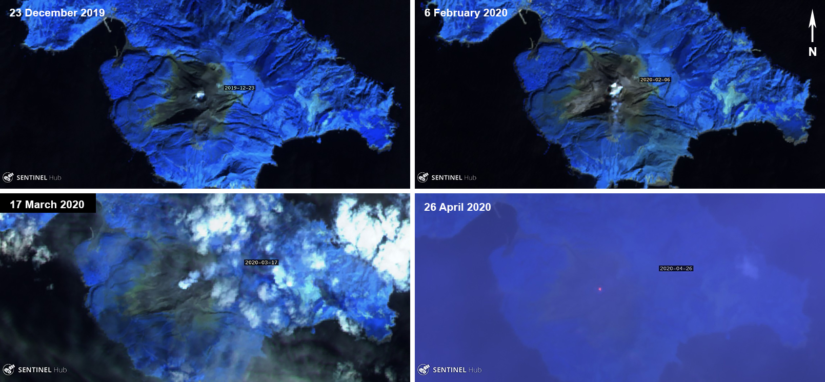 |
Figure 7. Sentinel-2 thermal satellite images showed gas-and-steam and ash emissions rising from Kuchinoerabujima. Some ash deposits can be seen on 6 February 2020 (top right). A thermal anomaly appeared on 26 April 2020 (bottom right). Sentinel-2 atmospheric penetration (bands 12, 11, 8A) images courtesy of Sentinel Hub Playground. |
An eruption on 11 January 2020 at 1505 ejected material 300 m from the crater and produced ash plumes that rose 2 km above the crater rim, extending E, according to JMA. The eruption continued through 12 January until 0730. The resulting ash plumes rose 400 m above the crater, drifting SW while the SO2 emissions measured 1,300 tons/day. Ashfall was reported on Yakushima Island (15 km E). Minor eruptive activity was reported during 17-20 January which produced gray-white plumes that rose 300-500 m above the crater. On 23 January, seismicity increased, and an eruption produced an ash plume that rose 1.2 km altitude, according to a Tokyo VAAC report, resulting in ashfall 2 km NE of the crater. A small explosion was detected on 24 January, followed by an increase in the number of earthquakes during 25-26 January (65-71 earthquakes per day were registered). Another small eruptive event detected on 27 January at 0148 was accompanied by a volcanic tremor and a change in tilt data. During the month of January, some inflation was detected at the base on the volcano and a total of 347 earthquakes were recorded. The SO2 emissions ranged from 200-1,600 tons/day.
An eruption on 1 February 2020 produced an eruption column that rose less than 1 km altitude and extended SE and SW (figure 8), according to the Tokyo VAAC report. On 3 February, an eruption from the Shindake crater at 0521 produced an ash plume that rose 7 km above the crater and ejected material as far as 600 m away. As a result, a pyroclastic flow formed, traveling 900-1,500 m SW. The previous pyroclastic flow that was recorded occurred on 29 January 2019. Ashfall was confirmed in the N part of Yakushima Island with a large amount in Miyanoura (32 km ESE) and southern Tanegashima. The SO2 emissions measured 1,700 tons/day during this event.
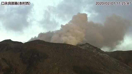 |
Figure 8. Webcam images from the Honmura west surveillance camera of an ash plume rising from Kuchinoerabujima on 1 February 2020. Courtesy of JMA (Weekly bulletin report 509, February 2020). |
Intermittent small eruptive events occurred during 5-9 February; field observations showed a large amount of ashfall on the SE flank which included lapilli that measured up to 2 cm in diameter. Additionally, thermal images showed 5-km-long pyroclastic flow deposits on the SW flank. An eruption on 9 February produced an ash plume that rose 1.2 km altitude, drifting SE. On 13 February a small eruption was detected in the Shindake crater at 1211, producing gray-white plumes that rose 300 m above the crater, drifting NE. Small eruptive events also occurred during 20-21 February, resulting in gas-and-steam emissions that rose 200 m above the crater. During the month of February, some horizontal extension was observed since January 2020 using GNSS data. The total number of earthquakes during this month drastically increased to 1225 compared to January. The SO2 emissions ranged from 300-1,700 tons/day.
By 2 March 2020, seismicity decreased, and activity declined. Gas-and-steam emissions continued infrequently for the duration of the reporting period. The SO2 emissions during March ranged from 700-2,100 tons/day, the latter of which occurred on 15 March. Seismicity increased again on 27 March. During 5-8 April 2020, small eruptive events were detected, generating ash plumes that rose 900 m above the crater (figure 9). The SO2 emissions on 6 April reached 3,200 tons/day, the maximum measurement for this reporting period. These small eruptive events continued from 13-20 and 23-25 April within the Shindake crater, producing gray-white plumes that rose 300-800 m above the crater.
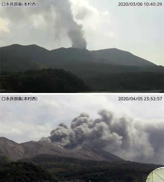 |
Figure 9. Webcam images from the Honmura Nishi (top) and Honmura west (bottom) surveillance cameras of ash plumes rising from Kuchinoerabujima on 6 March and 5 April 2020. Courtesy of JMA (Weekly bulletin report 509, March and April 2020). |
Geological Summary. A group of young stratovolcanoes forms the eastern end of the irregularly shaped island of Kuchinoerabujima in the northern Ryukyu Islands, 15 km W of Yakushima. The Furudake, Shindake, and Noikeyama cones were erupted from south to north, respectively, forming a composite cone with multiple craters. All historical eruptions have occurred from Shindake, although a lava flow from the S flank of Furudake that reached the coast has a very fresh morphology. Frequent explosive eruptions have taken place from Shindake since 1840; the largest of these was in December 1933. Several villages on the 4 x 12 km island are located within a few kilometers of the active crater and have suffered damage from eruptions.
Information Contacts: Japan Meteorological Agency (JMA), 1-3-4 Otemachi, Chiyoda-ku, Tokyo 100-8122, Japan (URL: http://www.jma.go.jp/jma/indexe.html); Tokyo Volcanic Ash Advisory Center (VAAC), 1-3-4 Otemachi, Chiyoda-ku, Tokyo 100-8122, Japan (URL: http://ds.data.jma.go.jp/svd/vaac/data/); Sentinel Hub Playground (URL: https://www.sentinel-hub.com/explore/sentinel-playground).