Report on Nyamulagira (DR Congo) — June 2020

Bulletin of the Global Volcanism Network, vol. 45, no. 6 (June 2020)
Managing Editor: Edward Venzke.
Edited by Kadie L. Bennis.
Nyamulagira (DR Congo) Intermittent thermal anomalies within the summit crater during December 2019-May 2020
Please cite this report as:
Global Volcanism Program, 2020. Report on Nyamulagira (DR Congo) (Bennis, K.L., and Venzke, E., eds.). Bulletin of the Global Volcanism Network, 45:6. Smithsonian Institution. https://doi.org/10.5479/si.GVP.BGVN202006-223020
Nyamulagira
DR Congo
1.408°S, 29.2°E; summit elev. 3058 m
All times are local (unless otherwise noted)
Nyamuragira (also known as Nyamulagira) is located in the Virunga Volcanic Province (VVP) in the Democratic Republic of the Congo and consists of a lava lake that reappeared in the summit crater in mid-April 2018. Volcanism has been characterized by lava emissions, thermal anomalies, seismicity, and gas-and-steam emissions. This report summarizes activity during December 2019 through May 2020 using information from monthly reports by the Observatoire Volcanologique de Goma (OVG) and satellite data.
According to OVG, intermittent eruptive activity was detected in the lava lake of the central crater during December 2019 and January-April 2020, which also resulted in few seismic events. MIROVA (Middle InfraRed Observation of Volcanic Activity) analysis of MODIS satellite data shows thermal anomalies within the summit crater that varied in both frequency and power between August 2019 and mid-March 2020, but very few were recorded afterward through late May (figure 81). Thermal hotspots identified by MODVOLC from 15 December 2019 through March 2020 were mainly located in the active central crater, with only three hotspots just outside the SW crater rim (figure 82). Sentinel-2 thermal satellite imagery also showed activity within the summit crater during January-May 2020, but by mid-March the thermal anomaly had visibly decreased in power (figure 83).
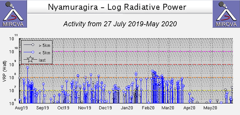 |
Figure 81. The MIROVA graph of thermal activity (log radiative power) at Nyamuragira during 27 July through May 2020 shows variably strong, intermittent thermal anomalies with a variation in power and frequency from August 2019 to mid-March 2020. Courtesy of MIROVA. |
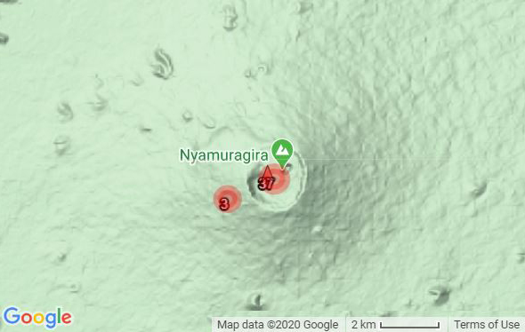 |
Figure 82. Map showing the number of MODVOLC hotspot pixels at Nyamuragira from 1 December 2019 t0 31 May 2020. 37 pixels were registered within the summit crater while 3 were detected just outside the SW crater rim. Courtesy of HIGP-MODVOLC Thermal Alerts System. |
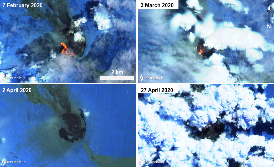 |
Figure 83. Sentinel-2 thermal satellite imagery (bands 12, 11, 8A) confirmed ongoing thermal activity (bright yellow-orange) at Nyamuragira from February into April 2020. The strength of the thermal anomaly in the summit crater decreased by late March 2020, but was still visible. Courtesy of Sentinel Hub Playground. |
Geological Summary. Africa's most active volcano, Nyamulagira (also known as Nyamuragira), is a massive high-potassium basaltic shield about 25 km N of Lake Kivu and 13 km NNW of the steep-sided Nyiragongo volcano. The summit is truncated by a small 2 x 2.3 km caldera that has walls up to about 100 m high. Documented eruptions have occurred within the summit caldera, as well as from the numerous flank fissures and cinder cones. A lava lake in the summit crater, active since at least 1921, drained in 1938, at the time of a major flank eruption. Recent lava flows extend down the flanks more than 30 km from the summit as far as Lake Kivu; extensive lava flows from this volcano have covered 1,500 km2 of the western branch of the East African Rift.
Information Contacts: Information contacts: Observatoire Volcanologique de Goma (OVG), Departement de Geophysique, Centre de Recherche en Sciences Naturelles, Lwiro, D.S. Bukavu, DR Congo; MIROVA (Middle InfraRed Observation of Volcanic Activity), a collaborative project between the Universities of Turin and Florence (Italy) supported by the Centre for Volcanic Risk of the Italian Civil Protection Department (URL: http://www.mirovaweb.it/); Hawai'i Institute of Geophysics and Planetology (HIGP) - MODVOLC Thermal Alerts System, School of Ocean and Earth Science and Technology (SOEST), Univ. of Hawai'i, 2525 Correa Road, Honolulu, HI 96822, USA (URL: http://modis.higp.hawaii.edu/); Sentinel Hub Playground (URL: https://www.sentinel-hub.com/exp.