Report on Krakatau (Indonesia) — June 2020

Bulletin of the Global Volcanism Network, vol. 45, no. 6 (June 2020)
Managing Editor: Edward Venzke.
Edited by Kadie L. Bennis.
Krakatau (Indonesia) Strombolian explosions, ash plumes, and crater incandescence during April 2020
Please cite this report as:
Global Volcanism Program, 2020. Report on Krakatau (Indonesia) (Bennis, K.L., and Venzke, E., eds.). Bulletin of the Global Volcanism Network, 45:6. Smithsonian Institution. https://doi.org/10.5479/si.GVP.BGVN202006-262000
Krakatau
Indonesia
6.1009°S, 105.4233°E; summit elev. 285 m
All times are local (unless otherwise noted)
Krakatau, located in the Sunda Strait between Indonesia’s Java and Sumatra Islands, experienced a major caldera collapse around 535 CE, forming a 7-km-wide caldera ringed by three islands. On 22 December 2018, a large explosion and flank collapse destroyed most of the 338-m-high island of Anak Krakatau (Child of Krakatau) and generated a deadly tsunami (BGVN 44:03). The near-sea level crater lake inside the remnant of Anak Krakatau was the site of numerous small steam and tephra explosions. A larger explosion in December 2019 produced the beginnings of a new cone above the surface of crater lake (BGVN 45:02). Recently, volcanism has been characterized by occasional Strombolian explosions, dense ash plumes, and crater incandescence. This report covers activity from February through May 2020 using information provided by the Indonesian Center for Volcanology and Geological Hazard Mitigation, also known as Pusat Vulkanologi dan Mitigasi Bencana Geologi (PVMBG), the Darwin Volcanic Ash Advisory Center (VAAC), and various satellite data.
Activity during February 2020 consisted of dominantly white gas-and-steam emissions rising 300 m above the crater, according to PVMBG. According to the Darwin VAAC, a ground observer reported an eruption on 7 and 8 February, but no volcanic ash was observed. During 10-11 February, a short-lived eruption was detected by seismograms which produced an ash plume up to 1 km above the crater drifting E. MAGMA Indonesia reported two eruptions on 18 March, both of which rose to 300 m above the crater. White gas-and-steam emissions were observed for the rest of the month and early April.
On 10 April PVMBG reported two eruptions, at 2158 and 2235, both of which produced dark ash plumes rising 2 km above the crater followed by Strombolian explosions ejecting incandescent material that landed on the crater floor (figures 108 and 109). The Darwin VAAC issued a notice at 0145 on 11 April reporting an ash plume to 14.3 km altitude drifting WNW, however this was noted with low confidence due to the possible mixing of clouds. During the same day, an intense thermal hotspot was detected in the HIMAWARI thermal satellite imagery and the NASA Global Sulfur Dioxide page showed a strong SO2 plume at 11.3 km altitude drifting W (figure 110). The CCTV Lava93 webcam showed new lava flows and lava fountaining from the 10-11 April eruptions. This activity was evident in the MIROVA (Middle InfraRed Observation of Volcanic Activity) graph of MODIS thermal anomaly data (figure 111).
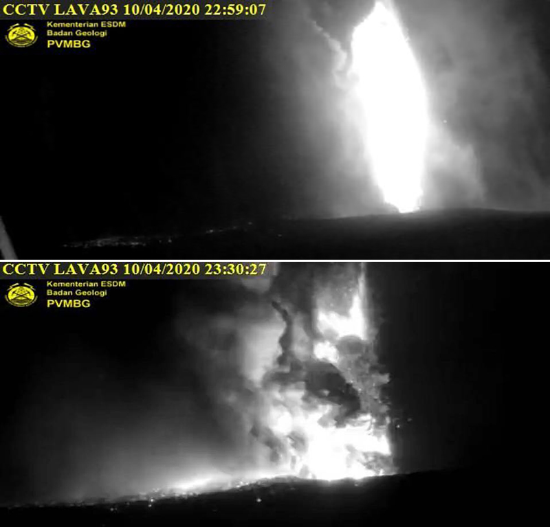 |
Figure 108. Webcam (Lava93) images of Krakatau on 10 April 2020 showing Strombolian explosions, strong incandescence, and ash plumes rising from the crater. Courtesy of PVMBG and MAGMA Indonesia. |
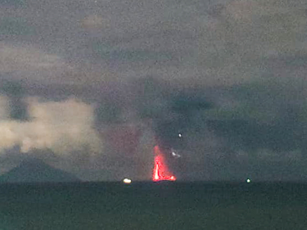 |
Figure 109. Webcam image of incandescent Strombolian explosions at Krakatau on 10 April 2020. Courtesy of PVMBG and MAGMA Indonesia. |
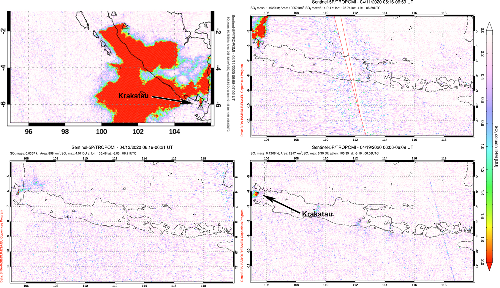 |
Figure 110. Strong sulfur dioxide emissions rising from Krakatau and drifting W were detected using the TROPOMI instrument on the Sentinel-5P satellite on 11 April 2020 (top row). Smaller volumes of SO2 were visible in Sentinel-5P/TROPOMI maps on 13 (bottom left) and 19 April (bottom right). Courtesy of NASA Global Sulfur Dioxide Monitoring Page. |
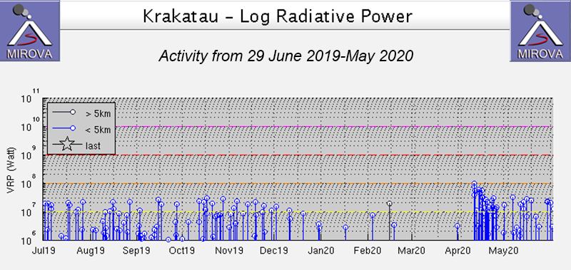 |
Figure 111. Thermal activity at Anak Krakatau from 29 June-May 2020 shown on a MIROVA Log Radiative Power graph. The power and frequency of the thermal anomalies sharply increased in mid-April. After the larger eruptive event in mid-April the thermal anomalies declined slightly in strength but continued to be detected intermittently through May. Courtesy of MIROVA. |
Strombolian activity rising up to 500 m continued into 12 April and was accompanied by SO2 emissions that rose 3 km altitude, drifting NW according to a VAAC notice. PVMBG reported an eruption on 13 April at 2054 that resulted in incandescence as high as 25 m above the crater. Volcanic ash, accompanied by white gas-and-steam emissions, continued intermittently through 18 April, many of which were observed by the CCTV webcam. After 18 April only gas-and-steam plumes were reported, rising up to 100 m above the crater; Sentinel-2 satellite imagery showed faint thermal anomalies in the crater (figure 112). SO2 emissions continued intermittently throughout April, though at lower volumes and altitudes compared to the 11th. MODIS satellite data seen in MIROVA showed intermittent thermal anomalies through May.
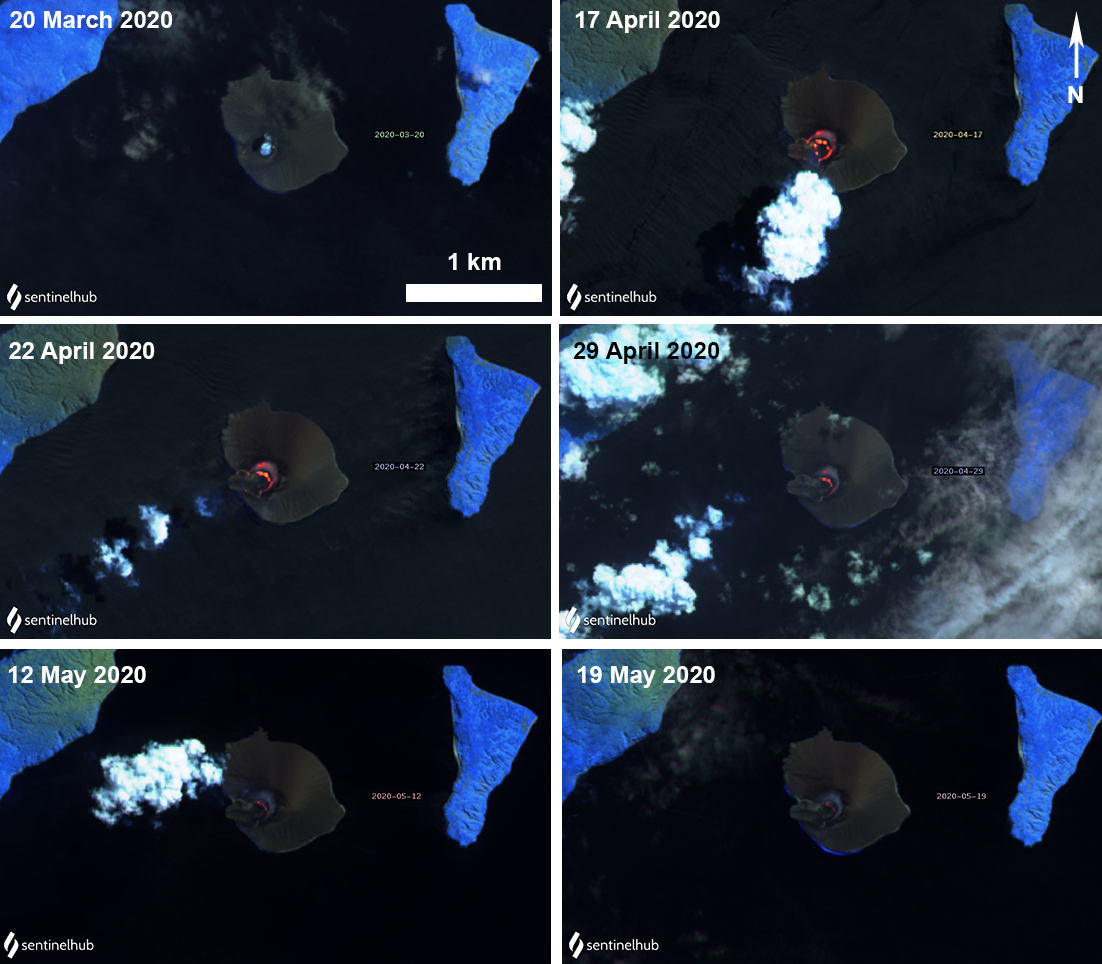 |
Figure 112. Sentinel-2 thermal satellite images showing the cool crater lake on 20 March (top left) followed by minor heating of the crater during April and May 2020. Sentinel-2 satellite images with “Atmospheric penetration” (bands 12, 11, 8A) rendering; courtesy of Sentinel Hub Playground. |
Geological Summary. The renowned Krakatau (frequently mis-named as Krakatoa) volcano lies in the Sunda Strait between Java and Sumatra. Collapse of an older edifice, perhaps in 416 or 535 CE, formed a 7-km-wide caldera. Remnants of that volcano are preserved in Verlaten and Lang Islands; subsequently the Rakata, Danan, and Perbuwatan cones were formed, coalescing to create the pre-1883 Krakatau Island. Caldera collapse during the catastrophic 1883 eruption destroyed Danan and Perbuwatan, and left only a remnant of Rakata. This eruption caused more than 36,000 fatalities, most as a result of tsunamis that swept the adjacent coastlines of Sumatra and Java. Pyroclastic surges traveled 40 km across the Sunda Strait and reached the Sumatra coast. After a quiescence of less than a half century, the post-collapse cone of Anak Krakatau (Child of Krakatau) was constructed within the 1883 caldera at a point between the former Danan and Perbuwatan cones. Anak Krakatau has been the site of frequent eruptions since 1927.
Information Contacts: Pusat Vulkanologi dan Mitigasi Bencana Geologi (PVMBG, also known as Indonesian Center for Volcanology and Geological Hazard Mitigation, CVGHM), Jalan Diponegoro 57, Bandung 40122, Indonesia (URL: http://www.vsi.esdm.go.id/); MAGMA Indonesia, Kementerian Energi dan Sumber Daya Mineral (URL: https://magma.vsi.esdm.go.id/); MIROVA (Middle InfraRed Observation of Volcanic Activity), a collaborative project between the Universities of Turin and Florence (Italy) supported by the Centre for Volcanic Risk of the Italian Civil Protection Department (URL: http://www.mirovaweb.it/); Global Sulfur Dioxide Monitoring Page, Atmospheric Chemistry and Dynamics Laboratory, NASA Goddard Space Flight Center (NASA/GSFC), 8800 Greenbelt Road, Goddard, Maryland, USA (URL: https://so2.gsfc.nasa.gov/); Sentinel Hub Playground (URL: https://www.sentinel-hub.com/explore/sentinel-playground).